| 
| |
|
|
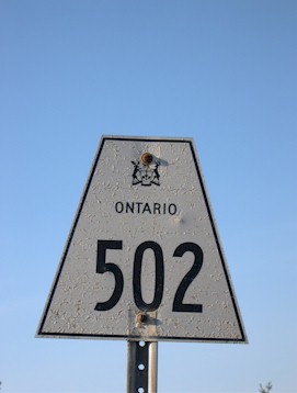
History of Secondary Highway 502 (#1):
There have been two Secondary Highways in Ontario known as Highway 502. The first route was a short collector highway in the Counties of Hastings and Lennox &
Addington, which linked Marysville to Napanee. The highway served as a short cut-off route so that through traffic on the Transprovincial Highway (Highway 2) could
bypass Deseronto. The route of Highway 2 did not offer motorists a particularly direct connection between Marysville and Napanee, because the highway turned a fair
distance to the south at Marysville. Accordingly, Highway 502 was a heavily-used alternate route to Highway 2 between these two communities. In the early 1960s,
traffic volumes on Highway 502 actually matched those seen on Highway 2 in many locations, making Highway 502 one of Ontario's busiest Secondary Highways. Highway 502
also holds the distinction as being Ontario's most southerly Secondary Highway. Highway 502's location south of Highway 401 makes it an interesting anomaly, as
Secondary Highways are typically only found in the lesser-populated northern regions of the province.
The history of Highway 502 dates back to the late 1950s, when the Belleville Road between Marysville and Napanee was acquired by the Department of Highways of Ontario (DHO) as a new provincial highway. Preliminary Route Plans were initially prepared in April 1956, which showed the proposed route of Highway 502 from the Highway 2 Junction at Marysville easterly to Napanee. However, unlike the other Secondary Highways designated en masse in May 1956, Highway 502 was for some reason omitted from the Order-in-Council schedule which established Ontario's Secondary Highway System. It is believed that the omission of Highway 502 from the Secondary Highway System designation of 1956 may have been inadvertent. An amending Order-in-Council was signed on February 14, 1957, which formally designated the route of Highway 502 under the same schedule which designated the 1956 Secondary Highway System. Provincial ownership of Highway 502 commenced when the highway was assumed into the provincial highway system on February 9, 1957. The route was approximately 8 miles (13 km) in length and was paved in its entirety at the time of designation. The entire route of Highway 502 was under the jurisdiction of the DHO, except for the section of the highway lying within the urbanized limits of the Town of Napanee. This non-assumed section of the highway along Bridge Street between Dundas Street (Highway 2) and West Street was designated as a Municipal Connecting Link in 1958. As the urban limits of Napanee expanded westerly in the 1960s, the DHO transferred jurisdiction over the section of Highway 502 (Belleville Road) between West Street and the western town limits near the Canadian National Railway (CNR) crossing to the Town of Napanee, effective April 1, 1969. Once Highway 401 was completed between Belleville and Napanee in the 1960s, most through traffic began to use the new freeway instead of Highway 2 and Highway 502. As a result, Highway 502 quickly declined in importance. The route of Highway 502 was retained in the provincial highway system up until the early 1970s, when jurisdiction over the highway from Marysville to the western limits of Napanee was transferred to the Counties of Hastings and Lennox & Addington, effective September 21, 1973. Although the first route of Highway 502 ceased to exist in 1973, another unrelated Highway 502 was established in Northwestern Ontario between Fort Frances and Dryden in 1981. |
|---|
Links to Adjacent Secondary Highway Pages: Website contents, photos & text © 2002-2023, Cameron
Bevers (Webmaster) - All Rights Reserved / Contact Me |
|---|