Ontario King's Highway 17B Ottawa Historical Route Maps
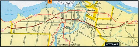
Route of King's Highway 17B in 1967, shortly after the establishment of the Ottawa Business Loop. See an Enlarged Map Here.
(Excerpt from the 1967 Official Ontario Road Map - © King's Printer for Ontario, 1967)
|

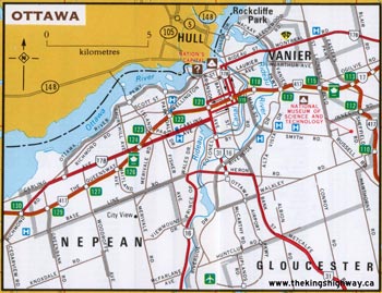
Route of King's Highway 17B in 1978, showing the relocation of the Business Route to Scott Street approaching downtown. See an Enlarged Map Here.
(Excerpt from the 1978-1979 Official Ontario Road Map - © King's Printer for Ontario, 1978)
|
Route of King's Highway 17B in 1982, showing the relocation of the Business Route to Carling Avenue and the one-way street system through downtown. See an Enlarged Map Here.
(Excerpt from the 1982-1983 Official Ontario Road Map - © King's Printer for Ontario, 1982)
|

Route of King's Highway 17B in 1992, just before the route ceased to be signed. See an Enlarged Map Here.
(Excerpt from the 1992-1993 Official Ontario Road Map - © King's Printer for Ontario, 1992)
|
|
|---|
Links to Other King's Highway Website Pages:
Website contents, photos & text © 2002-2026, Cameron
Bevers (Webmaster) - All Rights Reserved / Contact Me
|
|---|


