Ontario King's Highway 18A Historical Route Maps
Route of King's Highway 18A as it existed following assumption in 1938. See an
Enlarged Map Here
.
(Excerpt from the 1939-40 Official Ontario Road Map - © King's Printer for Ontario, 1939)
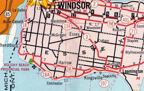
Route of King's Highway 18A as it existed in the 1960s, prior to downloading in the 1970s.
(Excerpt from the 1968 Official Ontario Road Map - © King's Printer for Ontario, 1968)
Links to Other King's Highway Website Pages:
Back to King's Highway 18A Page
Ontario Highway History - Main Menu
/
Back to List of Highways
Website contents, photos & text © 2002-2026, Cameron Bevers (Webmaster) - All Rights Reserved /
Contact Me