Ontario King's Highway 24A Historical Route Maps
Route of King's Highway 24A following the route renumbering in 1930. See an
Enlarged Map Here
.
(Excerpt from the 1933-34 Official Ontario Road Map - © King's Printer for Ontario, 1933)
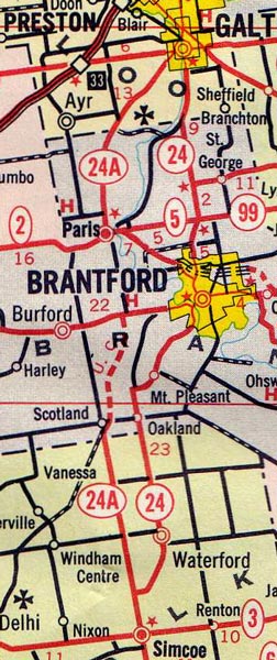
Route of King's Highway 24A in the mid-1960s, showing the new extension between Burford and Simcoe.
(Excerpt from the 1966 Official Ontario Road Map - © King's Printer for Ontario, 1966)
Route of King's Highway 24A in the 1990s, showing the highway truncated at the Brant-Waterloo Boundary.
(Excerpt from the 1992-1993 Official Ontario Road Map - © King's Printer for Ontario, 1992)
Links to Other King's Highway Website Pages:
Back to King's Highway 24A Page
Ontario Highway History - Main Menu
/
Back to List of Highways
Website contents, photos & text © 2002-2026, Cameron Bevers (Webmaster) - All Rights Reserved /
Contact Me