Ontario King's Highway 29 Historical Route Maps
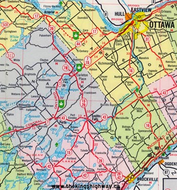
Route of King's Highway 29 in 1965, showing the highway's original northern terminus in Arnprior. See an Enlarged Map Here.
(Excerpt from the 1965 Official Ontario Road Map - © King's Printer for Ontario, 1965)
|

Route of King's Highway 29 in 1990, showing the highway's route after it was truncated in Smiths Falls in 1984. See an Enlarged Map Here.
(Excerpt from the 1990-1991 Official Ontario Road Map - © King's Printer for Ontario, 1990)
|
|
|---|
Links to Other King's Highway Website Pages:
Website contents, photos & text © 2002-2026, Cameron
Bevers (Webmaster) - All Rights Reserved / Contact Me
|
|---|


