Ontario King's Highway 3A Niagara Historical Route Maps

Route of Provincial Highway 3A (Niagara) as it existed after assumption in 1927. See an Enlarged Map Here.
(Excerpt from the 1928 Official Ontario Road Map - © King's Printer for Ontario, 1928)
|

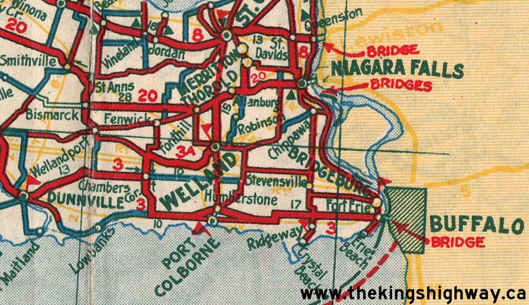
Route of King's Highway 3A (Niagara) as it existed after the renumbering of 1930. See an Enlarged Map Here.
(Excerpt from the 1933-34 Official Ontario Road Map - © King's Printer for Ontario, 1933)
|

Route of King's Highway 3A (Niagara) as it existed after the extension to St. Catharines in 1937. See an Enlarged Map Here.
(Excerpt from the 1938-39 Official Ontario Road Map - © King's Printer for Ontario, 1938)
|

Route of King's Highway 3A (Niagara) as it existed through Welland prior to 1959. See an Enlarged Map Here.
(Excerpt from the 1955 Official Ontario Road Map - © King's Printer for Ontario, 1955)
|

Route of King's Highway 3A (Niagara) as it existed through Welland after the rerouting via Prince Charles Drive in 1959. See an Enlarged Map Here.
(Excerpt from the 1960 Official Ontario Road Map - © King's Printer for Ontario, 1960)
|

Route of King's Highway 3A (Niagara) as it existed through Welland after being truncated at Hwy 58 (Prince Charles Drive) in 1965. See an Enlarged Map Here.
(Excerpt from the 1960 Official Ontario Road Map - © King's Printer for Ontario, 1960)
|
|
|---|
Links to Other King's Highway Website Pages:
Website contents, photos & text © 2002-2026, Cameron
Bevers (Webmaster) - All Rights Reserved / Contact Me
|
|---|