Ontario Secondary Highway 540B Historical Route Maps
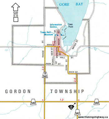
Route of King's Highway 540B as it existed before 1997. See an Enlarged Map Here.
Base map excerpt from the Ontario Transportation Map Series - © King's Printer for Ontario, 1992
Alterations & Additions by Josh Anderchek - © 2022-2026
|
|
|---|
Links to Other King's Highway Website Pages:
Website contents, photos & text © 2002-2026, Cameron
Bevers (Webmaster) - All Rights Reserved / Contact Me
|
|---|


