Ontario King's Highway 7B Carleton Place Historical Route Maps

Map showing the route of King's Highway 7B via Carleton Place in 1969. See an Enlarged Map Here.
(Excerpt from the 1969 Official Ontario Road Map - © King's Printer for Ontario, 1969)
|
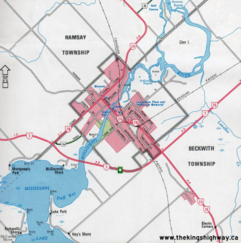
Detailed route map of King's Highway 7B after it was first established in 1961. See an Enlarged Map Here.
Base map excerpt from the Ontario Transportation Map Series - © King's Printer for Ontario, 1991
Alterations & Additions by Josh Anderchek - © 2023-2026
|

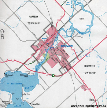
Detailed route map of King's Highway 7B after the full Business Loop via Bridge Street was discontinued in the 1970s. See an Enlarged Map Here.
Base map excerpt from the Ontario Transportation Map Series - © King's Printer for Ontario, 1991
Alterations & Additions by Josh Anderchek - © 2023-2026
|

Detailed route map of King's Highway 7B after the renumbering of Highway 29 in 1984. See an Enlarged Map Here.
Base map excerpt from the Ontario Transportation Map Series - © King's Printer for Ontario, 1991
Alterations & Additions by Josh Anderchek - © 2023-2026
|
Detailed route map of King's Highway 7B after the completion of the East Carleton Place Bypass in the 1990s. See an Enlarged Map Here.
Base map excerpt from the Ontario Transportation Map Series - © King's Printer for Ontario, 1991
Alterations & Additions by Josh Anderchek - © 2023-2026
|
|
|---|
Links to Other King's Highway Website Pages:
Website contents, photos & text © 2002-2026, Cameron
Bevers (Webmaster) - All Rights Reserved / Contact Me
|
|---|


