
| 
| |
|
|
This page contains historical and present day photos of Ontario's King's Highway 11A (Toronto). All photographs
displayed on this page were taken by the Webmaster (Cameron Bevers), unless specifically noted otherwise. Historical photographs are arranged in approximate
chronological order, while present day photographs (Year 2000 to date) are arranged by location from south to north. Click on any thumbnail to see a larger image!
Please note that all photographs displayed on this
website are protected by copyright. These photographs must not be reproduced, published,
electronically stored or copied, distributed, or posted onto other websites without
my written permission. If you want to use photos from this website, please
email me first for permission. Thank-you!
|
|---|
|
Historical King's Highway 11A (Toronto) Photographs

Above - Facing north along Hwy 11A (Avenue Road) at the Dupont Street Intersection in Toronto. Photo taken on August 11, 1931. (Photo Courtesy of the Toronto Transit Commission) 
Above - Facing south along Hwy 11A (Avenue Road) at the Wilson Avenue Intersection in Toronto. Photo taken on April 26, 1940. (Photo © Archives of Ontario - Series RG-14-162-3, Box A1353, Photo #2842S) 

Left - Facing north along Hwy 11A (Avenue Road) towards the Wilson Avenue Intersection. Photo taken on April 26, 1940. (Photo courtesy of Ontario Ministry of Transportation - © King's Printer for Ontario, 1953) Right - Facing north along Hwy 11A (Avenue Road) at the same location near Wilson Avenue. Photo taken on October 29, 1953. (Photo courtesy of Ontario Ministry of Transportation - © King's Printer for Ontario, 1953) 
Above - Hwy 11A at Queens Park in Toronto. Photo taken on August 18, 1952. (Photo courtesy of Ontario Ministry of Transportation - © King's Printer for Ontario, 1952) 
Above - Aerial view of the Hwy 401 & Hwy 11A (Avenue Road) Cloverleaf in Toronto, facing east. See an
Enlarged Photo Here. Photo taken on October 1, 1953. (Photo courtesy of Ontario Ministry of Transportation - © King's Printer for Ontario, 1953) 
Above - Evening rush hour traffic on the Toronto Bypass (Hwy 401), facing east from the Avenue Road (Hwy 11A) Cloverleaf. See an
Enlarged Photo Here. Photo taken on April 12, 1957. (Photo courtesy of Ontario Ministry of Transportation - © King's Printer for Ontario, 1957) 
Above - Circa 1958 view of Downtown Toronto from the intersection of York Street (Hwy 11A) and Fleet Street (Hwy 2). This view of Downtown Toronto is quite the
contrast to today's skyline. This photo was taken at a time when the Royal York Hotel (across from Union Station in the foreground) and Canadian Bank of Commerce
Building (background) were the tallest structures of the city's skyline. The Canadian Bank of Commerce building was Canada's tallest skyscraper when it was first
opened in 1932 - a record which went unbroken for more than 3 decades. Noticeably absent in this photo is the elevated portion of the Gardiner Expressway, which
wasn't built until the 1960s. Today, the Toronto skyline is filled with skyscrapers - a testament to Toronto's undisputed economic success and progress over the past
century. See an Enlarged Photo Here. Photo taken circa 1958. (Photo © Archives of Ontario - Series RG-65-35, Photo #I-0015001) 
Above - Hwy 401 at the Hwy 11A (Avenue Road) Cloverleaf in Toronto, looking east (1959) (Photo courtesy of Ontario Ministry of Transportation - © King's Printer for Ontario, 1959) 
Above - Piers for the new Hwy 11A (Avenue Road) Overpass under construction on the Toronto Bypass (Hwy 401) during the Winter of 1962-1963, Contract #1962-252.
The replacement of the Avenue Road structure was the first phase in the expansion of Hwy 401 from 4 to 12 lanes across Toronto. With the award of this contract on
October 17, 1962, the most extensive reconstruction of an Ontario freeway began - although initially only one mile of the highway through the Avenue Road Interchange
itself was impacted. As seen in this photo, the contractor poured the concrete piers in winter to accelerate construction. Sections of the piers were enclosed in
tarps to ensure that the concrete cured properly, despite cold ambient temperatures. This over-winter work allowed the completion of the new Avenue Road structure by
the end of the 1963 construction season and the removal of the old bridge in December of that year. See an
Enlarged Photo Here. Photo taken in 1963. (Photo courtesy of Ontario Ministry of Transportation - © King's Printer for Ontario, 1963) 
Above - Aerial view of the construction progress at the Hwy 11A (Avenue Road) Cloverleaf on Hwy 401 in Toronto, Contract #1962-252. This photo was taken in
the Summer of 1963 and shows the nearly-completed replacement Avenue Road Overpass crossing the new 12-lane widened section of Hwy 401. The new structure sits beside
the original 1952 structure crossing the old four-lane Toronto Bypass. The old Avenue Road structure was taken out of service and demolished a few months after
this photo was taken. See an Enlarged Photo Here. Photo taken in 1963. (Photo courtesy of Ontario Ministry of Transportation - © King's Printer for Ontario, 1963) 
Above - Aerial view of the completed 12-lane widening of Hwy 401 at the Hwy 11A (Avenue Road) Interchange in Toronto in 1964, facing east towards
the Hogg's Hollow Bridge. As the population of Toronto exploded upwards following World War II, traffic volumes on the newly-built Toronto Bypass also grew
dramatically. Toronto's population at the end of World War II was only about 650,000. In the 1940s, the highway's original planners had anticipated that four lanes
would be adequate to accommodate traffic along the Toronto Bypass for the foreseeable future. However, within three years of being opened to traffic in 1952, this
section of Hwy 401 was already carrying over 30,000 vehicles per day - roughly three times the traffic volumes that the highway's planners had forecast in the 1940s.
Traffic volumes had more than doubled again from 1955 levels to reach 64,000 vehicles per day by 1960. In response to these rapidly-growing traffic volumes along the
Toronto Bypass, the DHO awarded the first contract for the expansion of Hwy 401 across Metropolitan Toronto on October 17, 1962. The first contract for the widening
of a 1 mile section of the Toronto Bypass included a full replacement of the original Avenue Road Cloverleaf seen in this
1959 Aerial Photo and construction of a new Express-Collector Lane System under Contract
#1962-252. Ontario road map collectors have likely seen this photo before, as it was prominently featured on the front cover of the 1965 Edition of the Official
Ontario Road Map. See an Enlarged Photo Here. Photo taken in October 1964. (Photo courtesy of Ontario Ministry of Transportation - © King's Printer for Ontario, 1964) |
|---|
|
Present Day King's Highway 11A (Toronto) Photographs


Left - Approaching the Dufferin Street Interchange on the Eastbound Hwy 401 Collector Lanes in Toronto. (Photograph taken on March 15, 2009 - © Cameron Bevers) Right - Interchange sequence sign at the Dufferin Street Interchange on the Eastbound Hwy 401 Collector Lanes. Compare this photo to the one above, showing the same sign a year earlier. Note that the reference to Hwy 11A for the Avenue Road Interchange has been removed. (Photograph taken on May 29, 2010 - © Cameron Bevers) 

Left - First-generation COMPASS changeable message sign on the Eastbound Hwy 401 Collector Lanes approaching the Hwy 11A (Avenue Road) Interchange.
These electronic signs were installed in 1989-1990 in preparation for the launch of the Ministry of Transportation's new freeway traffic management system
(COMPASS) in 1991. Most of these early electronic signs were replaced with new changeable message signs along the Hwy 401 corridor in 2010, but this sign
has remained in service to this day. It will be replaced during an upcoming highway reconstruction project. (Photograph taken on May 29, 2010 - © Cameron Bevers) Right - Advance guide sign for Hwy 11A (Avenue Road) on the Eastbound Hwy 401 Collector Lanes. References to Hwy 11A were discontinued on overhead signs for Avenue Road along Hwy 401 during 2009-2010. See an Enlarged Photo Here. (Photograph taken on March 15, 2009 - © Cameron Bevers) 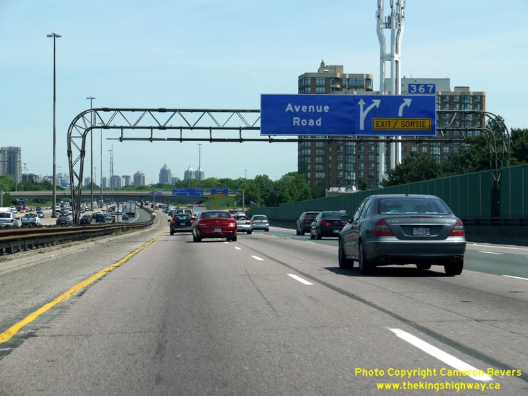

Left - Advance guide sign for Avenue Road on the Eastbound Hwy 401 Collector Lanes. Note that the Hwy 11A crown has been removed from the sign. (Photograph taken on May 29, 2010 - © Cameron Bevers) Right - Hwy 11A (Avenue Road) Overpass on Hwy 401 in Toronto. Structure completed in 1963. (Photograph taken on March 15, 2009 - © Cameron Bevers) 

Left - Facing east along Hwy 401 from the Hwy 11A (Avenue Road) Overpass in Toronto. See an
Enlarged Photo Here. (Photograph taken on March 15, 2009 - © Cameron Bevers) Right - Overhead guide sign marking the on-ramp to Westbound Hwy 401 from Northbound Hwy 11A (Avenue Road). This interchange marked the northern terminus of Hwy 11A until the highway was decommissioned in 1997. See an Enlarged Photo Here. (Photograph taken on March 15, 2009 - © Cameron Bevers) 

Left - Facing south along Hwy 11A (Avenue Road) from the highway's northern terminus at the Hwy 401 Interchange. (Photograph taken on March 15, 2009 - © Cameron Bevers) Right - Aerial view of the Hwy 11A (Avenue Road) Interchange on Hwy 401, facing south towards Downtown Toronto. Avenue Road offers a fairly direct route into Downtown Toronto from Hwy 401. See an Enlarged Photo Here. (Photograph taken on May 30, 2004 - © Cameron Bevers)
More King's Highway 11A Photographs Coming Soon!
|
|---|
Links to Adjacent King's Highway Photograph Pages:
Back to King's Highway 11 Photos /
King's Highway 11A (Toronto) History /
On to King's Highway 12 Photos
Ontario Highway History - Main Menu / Back to List of Highways Website contents, photos & text © 2002-2026, Cameron
Bevers (Webmaster) - All Rights Reserved / Contact Me
|
|---|