
| 
| |
|
|
This page contains historical and present day photos of Ontario's King's Highway 18A. Please note that this route is officially
known as Essex County Road 50 today. All photographs displayed on this page were taken by the Webmaster (Cameron Bevers), unless specifically noted otherwise.
Historical photographs are arranged in approximate chronological order, while present day photographs (2010 to date) are arranged by location from west to east.
Click on any thumbnail to see a larger image!
Please note that all photographs displayed on this
website are protected by copyright. These photographs must not be reproduced, published,
electronically stored or copied, distributed, or posted onto other websites without
my written permission. If you want to use photos from this website, please
email me first for permission. Thank-you!
|
|---|
|
Historical King's Highway 18A Photographs


Left - Facing west along Hwy 18A (today's Essex County Road 50) towards Colchester at the Wigle Creek Bridge near Linden Beach. See an
Enlarged Photo Here. (Photograph taken on March 27, 2005 - © Cameron Bevers) Right - View of the Wigle Creek Bridge (MTO Site #6-185) on Hwy 18A at the western entrance to Linden Beach. This single-span steel beam structure was completed in 1932. This bridge was actually constructed by the County of Essex, several years prior to Hwy 18A being assumed as a provincial highway in 1938. See an Enlarged Photo Here. (Photograph taken on March 27, 2005 - © Cameron Bevers) 

Left - Facing east along Hwy 18A towards Linden Beach at the Wigle Creek Bridge. See an
Enlarged Photo Here. (Photograph taken on March 27, 2005 - © Cameron Bevers) Right - Southern side of the Wigle Creek Bridge on Hwy 18A between Linden Beach and Colchester. This structure was replaced soon after I took this photo in 2005. See an Enlarged Photo Here. (Photograph taken on March 27, 2005 - © Cameron Bevers) |
|---|
|
Present Day King's Highway 18A Photographs


Left - Facing west along Hwy 18 towards Amherstburg from the Former Hwy 18A Junction at Malden Centre. Like many King's Highways in Southwestern Ontario,
jurisdiction over the entire route of Hwy 18 was transferred or "downloaded" from the province to the municipal tier in the late 1990s. This former King's Highway was
transferred to the County of Essex in 1998 and is officially known as Essex County Road 20 today. The section of Hwy 18 seen in this photo is actually a diversion
built in the 1930s to bypass two 90-degree turns in the original highway's route. See an
Enlarged Photo Here. (Photograph taken on August 2, 2019 - © Cameron Bevers) Right - Approaching the Former Hwy 18A Junction at Malden Centre, facing east along Hwy 18 towards Harrow. Up until the late 1970s, Hwy 18A formed an alternate route to Hwy 18 along the Lake Erie shoreline via Colchester. After provincial jurisdiction over Hwy 18A ended in 1978, the former highway became known as Essex Road 50. See an Enlarged Photo Here. (Photograph taken on August 2, 2019 - © Cameron Bevers) 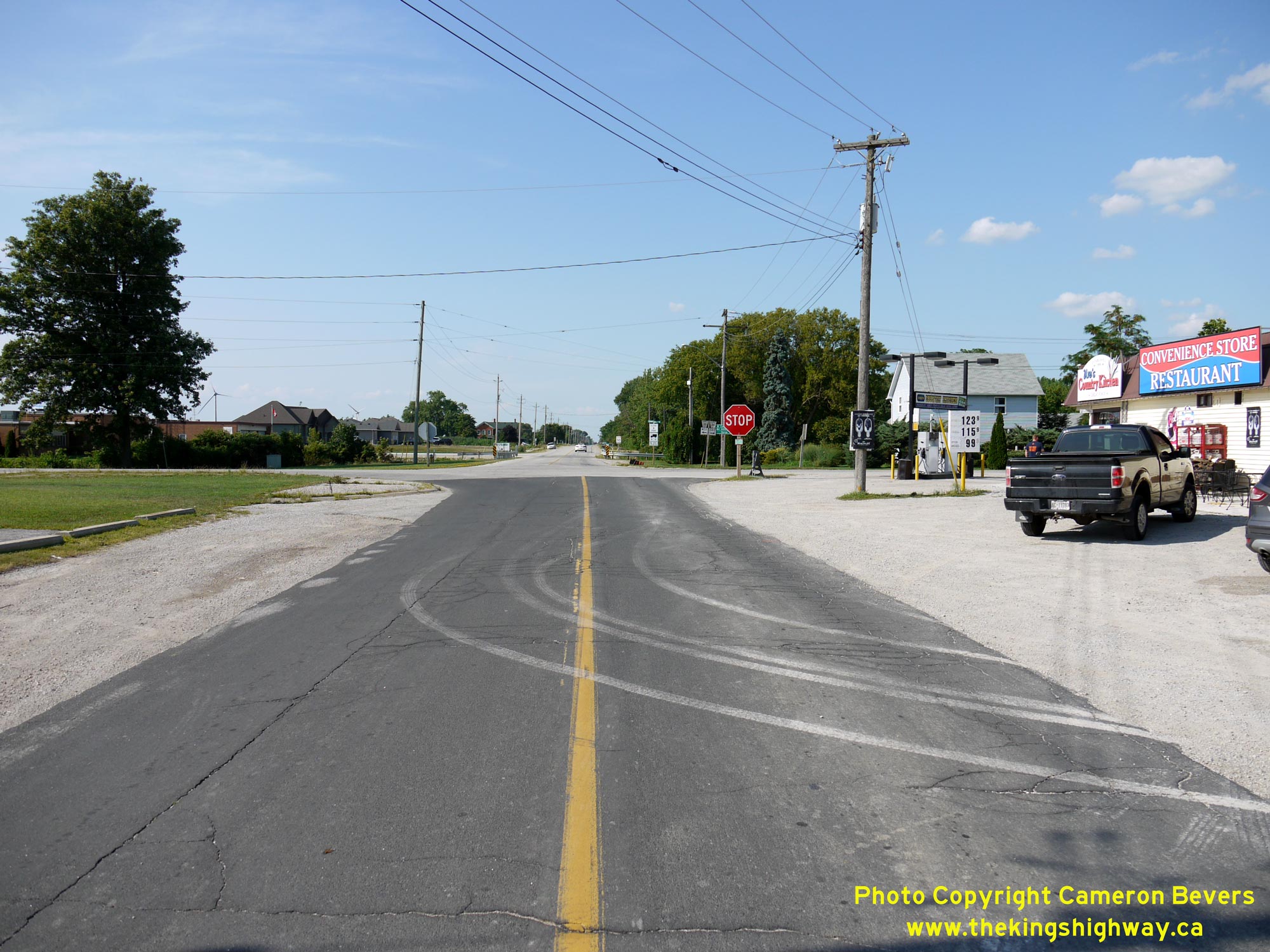
Left - Approaching the western terminus of Former Hwy 18A at the Hwy 18 Junction at Malden Centre. Up until the late 1970s, Hwy 18A formed a loop from Malden
Centre easterly to Kingsville via Colchester, with Hwy 18A connecting back to Hwy 18 at both ends of the loop. See an
Enlarged Photo Here. (Photograph taken on August 2, 2019 - © Cameron Bevers) Right - Facing east along Former Hwy 18A towards Colchester from the Hwy 18 Junction at Malden Centre. This route was first assumed by the Department of Highways of Ontario (DHO) as a King's Highway in April 1938. The route remained in the provincial highway system for just over 40 years, but ownership of the highway was eventually transferred over to the County of Essex in July 1978. Former Hwy 18A is officially known as Essex County Road 50 today. This former King's Highway is rather noteworthy, in that it was Canada's southernmost provincial highway at the time of its existence. See an Enlarged Photo Here. (Photograph taken on August 2, 2019 - © Cameron Bevers) 

Left - Junction sign assembly at the Hwy 18 & Former Hwy 18A Junction at Malden Centre. The old Hwy 18 provincial crown route markers were replaced with
newer Essex County Road 20 "flowerpot" route markers in the 1990s. Unfortunately, Essex County already had a rather lengthy County Road 18 in their road system and
was therefore forced to change the old Hwy 18 designation to something different once the county took over the highway in 1998. When Hwy 18 was first assumed as a
King's Highway in 1931, the route of Hwy 18 actually turned and followed Concession Road 6 northerly for a short distance before it resumed its route west towards
Amherstburg. This old loop of Hwy 18 was bypassed by a new highway diversion from Malden Centre westerly in 1932. There is no longer any trace of the bypassed former
east-west portion of Hwy 18 lying between the highway diversion and Concession Road 6. Jurisdiction over the old loop of Hwy 18 at Malden Centre reverted to the
Township of Malden in October 1932. See an Enlarged Photo Here. (Photograph taken on August 2, 2019 - © Cameron Bevers) Right - Facing west along Hwy 18 towards Amherstburg at Malden Centre, approaching the Former Hwy 18A Junction. See an Enlarged Photo Here. (Photograph taken on August 2, 2019 - © Cameron Bevers) 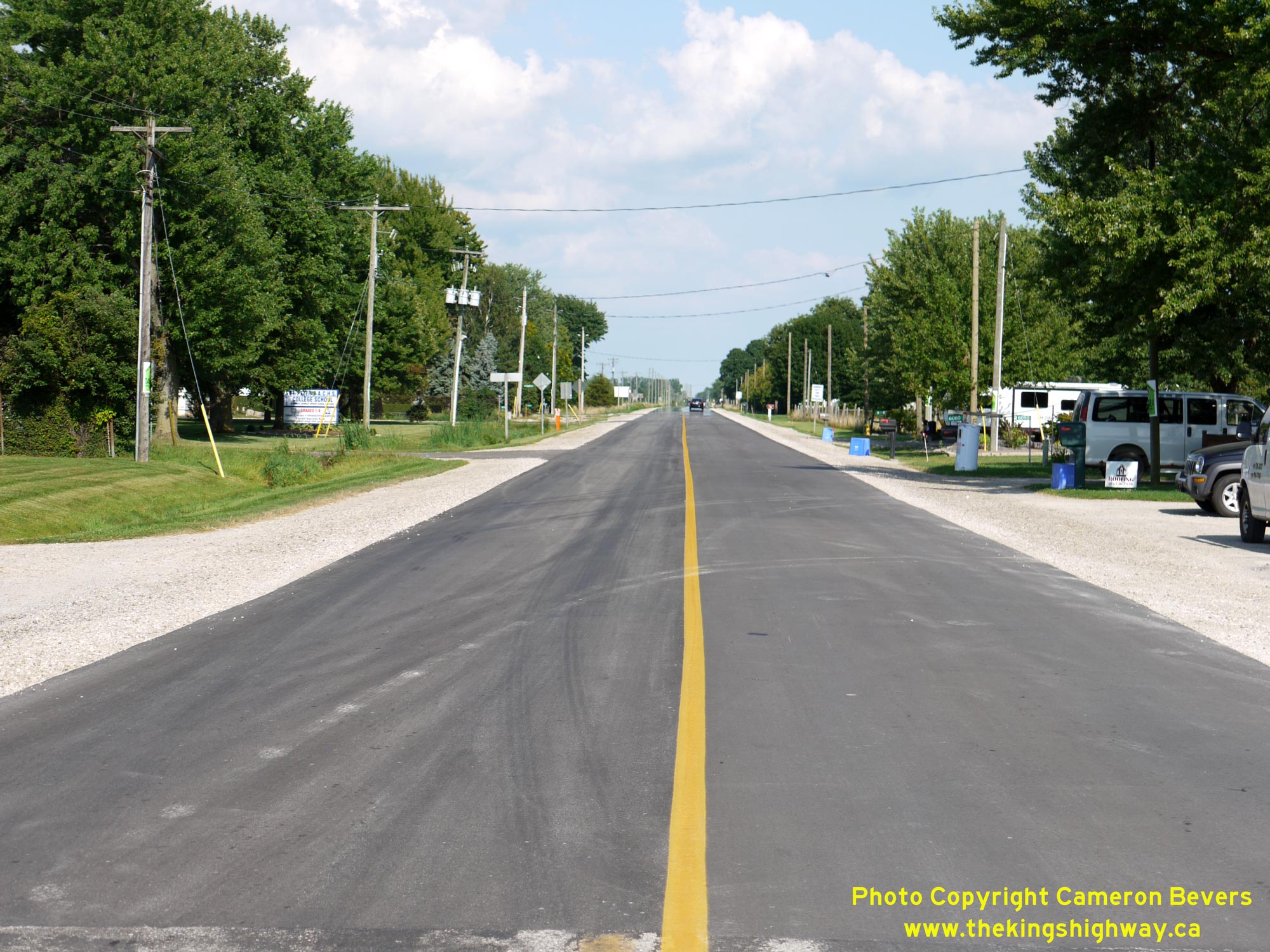

Left - Facing east along Hwy 18 towards Harrow from the Former Hwy 18A Junction at Malden Centre. During the 1930s, this section of Hwy 18 was abuzz with
activity. The province assumed jurisdiction over the road in December 1931, and immediately commenced an extensive Depression-era unemployment relief project. At the
height of construction activities in 1932, more than 2,000 people found temporary employment building this highway between Amherstburg and Kingsville. This section of
Hwy 18 has been recently resurfaced by Essex County. Unlike many other King's Highways in Southwestern Ontario which were originally constructed with a concrete
surface, this section of Hwy 18 has always been surfaced with asphalt. In 1936, a bituminous penetration macadam pavement was constructed for a distance of about 7
miles between Malden Centre and Harrow under Contract #1936-37. This paving contract completed paving operations along Hwy 18, as it closed the final gap in the
pavement between Windsor and Leamington. See an Enlarged Photo Here. (Photograph taken on August 2, 2019 - © Cameron Bevers) Right - Approaching Malden Centre on Hwy 18, facing west. Although the sign is broken, traffic is guided to the Holiday Beach Conservation Area via Essex County Road 50 (Former Hwy 18A). Years ago, Holiday Beach Park was operated by the Ontario Department of Lands and Forests as a Provincial Park. However, the local conservation authority has operated Holiday Beach Park since the 1980s. See an Enlarged Photo Here. (Photograph taken on August 2, 2019 - © Cameron Bevers) 

Left - Approaching Malden Centre on Hwy 18A, facing west. See an
Enlarged Photo Here. (Photograph taken on August 2, 2019 - © Cameron Bevers) Right - Facing east along Hwy 18A towards Colchester from the southern entrance to Malden Centre. See an Enlarged Photo Here. (Photograph taken on August 2, 2019 - © Cameron Bevers) 

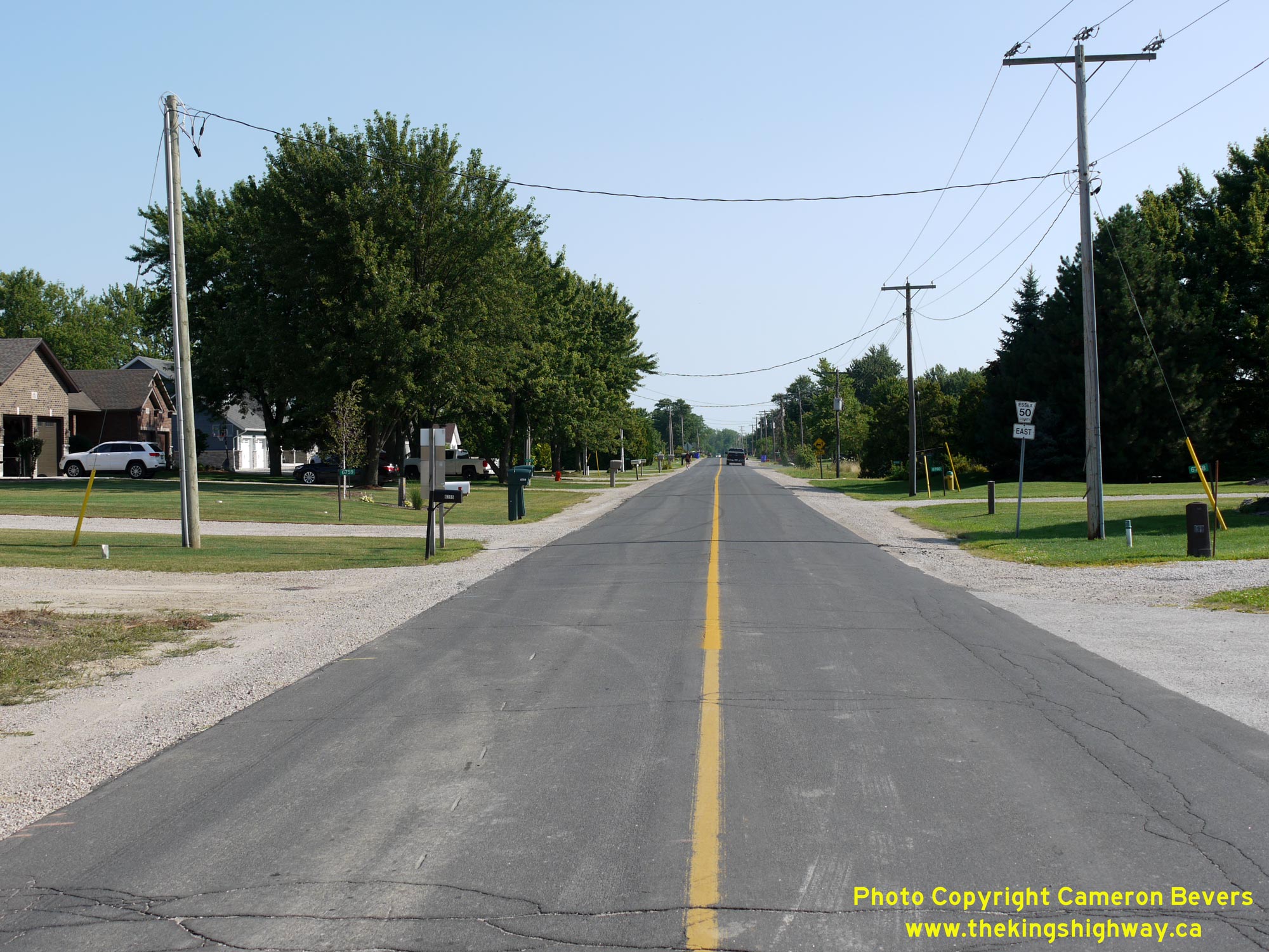
Left - View of Hwy 18A about 3 km east of Malden Centre, facing east. No, it isn't just your imagination - this is a really narrow highway pavement!
According to historical DHO records, Hwy 18A was originally designed with a total pavement width of only 18 feet - or 9 feet (2.75 m) per lane. During resurfacing of
the highway in the 1970s, the highway pavement was widened out slightly to 20 feet, which resulted in 10-foot (3.05 m) traffic lanes. One might notice that in my
photos of this highway, several vehicles are captured "hugging" the highway centreline, including the black minivan in the background of this photo. Centreline
encroachment is a driver behaviour that is often observed on roads with narrow pavements, as motorists have a tendency to shy away from obstructions such a utility
poles along the right-hand side of the road. See an Enlarged Photo Here. (Photograph taken on August 2, 2019 - © Cameron Bevers) Right - Facing east along Hwy 18A towards Colchester, about 4 km east of Malden Centre. See an Enlarged Photo Here. (Photograph taken on August 2, 2019 - © Cameron Bevers) 

Left - Blue-and-white Town of Amherstburg municipal boundary sign on westbound Hwy 18A near the Essex County Road 41 (Meadows Road) Junction. See an
Enlarged Photo Here. (Photograph taken on August 2, 2019 - © Cameron Bevers) Right - Facing west along Hwy 18A towards Malden Centre from the Essex County Road 41 Junction, located about 8 km west of Colchester. A short section of concrete curb-and-gutter exists here, due to the presence of a roadside business. Commercial entrances have to be designed in such a way that access and egress points to the site are well-defined and carefully controlled. Excessively wide commercial entrances for roadside businesses can cause additional traffic conflict points along the highway and can also confuse motorists. See an Enlarged Photo Here. (Photograph taken on August 2, 2019 - © Cameron Bevers) 

Left - Blue-and-white Town of Essex municipal boundary sign on eastbound Hwy 18A. Essex County Road 41 forms the boundary line between these two
municipalities. See an Enlarged Photo Here. (Photograph taken on August 2, 2019 - © Cameron Bevers) Right - Facing east along Hwy 18A about 7 km west of Colchester. Many of Ontario's older King's Highways of 1930s vintage tended to have rambling alignments, with oddly-shaped horizontal curves and frequent vertical dips. Through decades of costly reconstruction, the horizontal and vertical alignments of most King's Highways were eventually corrected. On the other hand, lesser-travelled highways were sometimes left behind, as priority was given to reconstructing highways with heavy traffic volumes - particularly those which were major commercial trucking routes. The route of Hwy 18A was never reconstructed to any great extent, so this scenic route offers observers a fascinating view of what many King's Highways once looked like in past decades. See an Enlarged Photo Here. (Photograph taken on August 2, 2019 - © Cameron Bevers) 

Left - View of Hwy 18A facing east towards Malden Centre, about 7 km west of Colchester. Since Hwy 18A has only ever served as a local highway to provide
access to the various beach communities along the Lake Erie shoreline, this route is very leisurely and carries comparatively little traffic. Most through traffic
travelling between Amherstburg and Kingsville uses Hwy 18 (today's Essex Road 20) via Harrow, as it is a faster and much more direct highway connection. See an
Enlarged Photo Here. (Photograph taken on August 2, 2019 - © Cameron Bevers) Right - Facing west along Hwy 18A between Ambassador Beach and Belcreft Beach. See an Enlarged Photo Here. (Photograph taken on August 2, 2019 - © Cameron Bevers) 

Left - Facing east along Hwy 18A towards Colchester from Ambassador Beach Road. See an
Enlarged Photo Here. (Photograph taken on August 2, 2019 - © Cameron Bevers) Right - View of Hwy 18A about 5 km west of Colchester, facing east. The historical route of Hwy 18A existed in the provincial highway system for four decades, from 1938 up until 1978. This route is officially known today as Essex County Road 50. See an Enlarged Photo Here. (Photograph taken on August 2, 2019 - © Cameron Bevers) 

Left - Facing east along Hwy 18A at Lake Crest Beach Road, about 4 km west of Colchester. See an
Enlarged Photo Here. (Photograph taken on August 2, 2019 - © Cameron Bevers) Right - Facing east along Hwy 18A towards Colchester near Cornwall Beach Road, about 1 km east of Seymour Beach. This highway underwent a fairly significant reconstruction in the early 1950s. The road was reshaped with a new granular base course laid under Contract #1951-82 between Colchester and Malden Centre. This section of the highway was paved with a mulch asphalt surface by DHO's District #1 (Chatham District) crews during 1952. When paving was completed along this section of Hwy 18A during the Summer of 1952, it also marked the completion of paving operations along all of the King's Highways located within DHO's Chatham District. See an Enlarged Photo Here. (Photograph taken on August 2, 2019 - © Cameron Bevers) 

Left - Crossing the 42nd Parallel on Hwy 18A near Seymour Beach, facing east towards Colchester. One of Hwy 18A's most noteworthy features is that its route
briefly dips south of the 42nd parallel of latitude - the only King's Highway in Ontario, either current or former, to have ever done so. This highway is located so
far south, that a small portion of California near its northern state lane is actually located further north than portions of Hwy 18A near Colchester. The 42nd
Parallel on Hwy 18A is impossible to miss - Essex County prominently announces the line's crossing with a pair of special "42" pavement markings in both the
eastbound and westbound lane. See an Enlarged Photo Here. (Photograph taken on August 2, 2019 - © Cameron Bevers) Right - Facing east along Hwy 18A towards Colchester about 2 km east of Seymour Beach. The route of Hwy 18A offers motorists with a very pleasant itinerary, as the highway winds its way through wineries, farms and many small beach communities. See an Enlarged Photo Here. (Photograph taken on August 2, 2019 - © Cameron Bevers) 

Left - Facing west along Hwy 18A towards Seymour Beach, facing west. Many section of Hwy 18A do not have roadside ditches. Rather, stormwater runoff is
collected through shallow roadside drainage swales which lead to deeper drainage outlets. Essex County is so flat that millimetres can count when it comes to
designing roadside drainage systems. See an Enlarged Photo Here. (Photograph taken on August 2, 2019 - © Cameron Bevers) Right - View of Hwy 18A about 2 km west of Colchester facing west towards Seymour Beach. This highway curve was constructed in the mid-1970s. It bypassed a sharp turn in the highway's original alignment. Prior to reconstruction in the 1970s, Hwy 18A passed through the residential property at right, before turning sharply to the left. The old highway alignment was graded out and is no longer apparent today. See an Enlarged Photo Here. (Photograph taken on August 2, 2019 - © Cameron Bevers) 

Left - Reverse curve along Hwy 18A between Seymour Beach and Colchester, facing east. See an
Enlarged Photo Here. (Photograph taken on August 2, 2019 - © Cameron Bevers) Right - Facing west along Hwy 18A from Marsden Beach Road, located about 1 km east of Colchester. This well-designed superelevated curve was built to carry fast through traffic. Interestingly, this curve and the one located immediately to the west were both constructed comparatively recently in the mid-1970s. Under Contract #1974-170, both of these curves were constructed with an 818.5-foot radius to replace two abrupt turns in the original highway's alignment. The old highway's alignment leading into the two corners was abandoned and graded out. See an Enlarged Photo Here. (Photograph taken on August 2, 2019 - © Cameron Bevers) 

Left - Facing east along Hwy 18A towards Colchester from Marsden Beach Road. See an
Enlarged Photo Here. (Photograph taken on August 2, 2019 - © Cameron Bevers) Right - Facing east along Hwy 18A towards Colchester from Wabasso Road. Note that paved shoulders begin along Hwy 18A just ahead. See an Enlarged Photo Here. (Photograph taken on August 2, 2019 - © Cameron Bevers) 

Left - Approaching Colchester on Hwy 18A, facing east. This is the largest community located along the route of Hwy 18A, apart from Kingsville located at the
highway's eastern terminus. Colchester is not an incorporated village in its own right, but is actually part of the much larger Town of Essex. Note the paved
shoulders constructed along this section of Hwy 18A, evidently as part of a highway retrofit project. See an
Enlarged Photo Here. (Photograph taken on August 2, 2019 - © Cameron Bevers) Right - Facing east along Hwy 18A towards Dunns Road in Colchester. The route of Hwy 18A passes through a reverse curve at Dunns Road. Although this may look like a T-intersection, Hwy 18A is actually the through highway as it curves sharply to the right. Dunns Road is under Stop-control. See an Enlarged Photo Here. (Photograph taken on August 2, 2019 - © Cameron Bevers) 

Left - Facing west along Hwy 18A towards Seymour Beach from Dunns Road in Colchester. See an
Enlarged Photo Here. (Photograph taken on August 2, 2019 - © Cameron Bevers) Right - View of the reverse curve along Hwy 18A at Dunns Road in Colchester. The location of this curve created two offset intersections for Dunns Road, which has resulted in a very awkward intersection layout. See an Enlarged Photo Here. (Photograph taken on August 2, 2019 - © Cameron Bevers) 

Left - Facing west along Hwy 18A at the reverse curve at Dunns Road in Colchester. Traffic on Hwy 18A curves right and then immediately to the left, while
traffic on both legs of Dunns Road has to wait before entering the highway. A painted pedestrian path can be seen at lower left, which was apparently installed to
discourage vehicle parking on the paved apron behind the curb. The DHO would typically design highways through small villages such as this with a paved apron which
served as a parking lane as well as a pedestrian facility. However, this design can be problematic in areas where on-street parking demand is very heavy and the paved
apron is frequently occupied by vehicles. See an Enlarged Photo Here. (Photograph taken on August 2, 2019 - © Cameron Bevers) Right - View of Hwy 18A (Murdoch Street) approaching Sydenham Street in Colchester. Throughout the village, the paved apron behind the curb has been marked as a pedestrian facility in an effort to discourage on-street parking. See an Enlarged Photo Here. (Photograph taken on August 2, 2019 - © Cameron Bevers) 

Left - Approaching the Essex County Road 13 Junction on Hwy 18A at Colchester. At the intersection, Hwy 18A turns right and continues east towards Kingsville.
See an Enlarged Photo Here. (Photograph taken on August 2, 2019 - © Cameron Bevers) Right - View of Hwy 18A (Murdoch Street) in Colchester, facing west from the Essex County Road 13 Junction. See an Enlarged Photo Here. (Photograph taken on August 2, 2019 - © Cameron Bevers) 

Left - Approaching Colchester on Hwy 18A, facing west towards the Essex County Road 13 Junction. At this intersection, the route of Hwy 18A turns left and
heads into the urbanized area of Colchester. Originally, Hwy 18A continued straight ahead as this was previously a Y-intersection. However, the intersection was
subsequently realigned so that both roads intersected at a right angle. See an
Enlarged Photo Here. (Photograph taken on August 2, 2019 - © Cameron Bevers) Right - Facing east along Hwy 18A (today's Essex County Road 50) from the Essex County Road 13 Junction in Colchester. As the highway rounds this curve, it reaches its southernmost point along the Lake Erie shoreline. East of this highway curve, Hwy 18A's route gradually trends to the north as it heads east towards Kingsville. See an Enlarged Photo Here. (Photograph taken on August 2, 2019 - © Cameron Bevers) 

Left - Eastern entrance to Colchester of Hwy 18A, facing west. See an
Enlarged Photo Here. (Photograph taken on August 2, 2019 - © Cameron Bevers) Right - View of Hwy 18A departing from Colchester, facing east towards Kingsville. See an Enlarged Photo Here. (Photograph taken on August 2, 2019 - © Cameron Bevers) 

Left - View of Hwy 18A between Colchester and Oxley. This section of the highway was recently resurfaced with a narrow paved shoulder on both sides of the
highway. See an Enlarged Photo Here. (Photograph taken on August 2, 2019 - © Cameron Bevers) Right - Facing west along Hwy 18A towards Colchester from Craig Beach, near the western entrance to Oxley. See an Enlarged Photo Here. (Photograph taken on August 2, 2019 - © Cameron Bevers) 

Left - View of Hwy 18A approaching the western entrance to Oxley, facing east. See an
Enlarged Photo Here. (Photograph taken on August 2, 2019 - © Cameron Bevers) Right - Facing west along Hwy 18A towards Colchester at the eastern entrance to Oxley. This small community lies about 3 km east of Colchester and about 8 km west of Cedar Beach. The mature roadside trees along the Hwy 18A corridor provide a cool and refreshing canopy on a hot summer day! See an Enlarged Photo Here. (Photograph taken on August 2, 2019 - © Cameron Bevers) 

Left - Facing east along Hwy 18A from the eastern entrance to Oxley. See an
Enlarged Photo Here. (Photograph taken on August 2, 2019 - © Cameron Bevers) Right - A pair of ancient oak trees tower over Hwy 18A as the highway approaches this curve east of Oxley. See an Enlarged Photo Here. (Photograph taken on August 2, 2019 - © Cameron Bevers) 

Left - Facing east along Hwy 18A from Schiller Beach Road near Oxley. See an
Enlarged Photo Here. (Photograph taken on August 2, 2019 - © Cameron Bevers) Right - Facing east along Hwy 18A from Evergreen Beach Lane, east of Colchester. Hwy 18A winds its way past rows of summer lakefront homes and wineries between Colchester and Cedar Beach. The meandering route, the leisurely pace and low traffic volumes along this highway provides some pleasant insights as to what early motoring would have been like on all of Ontario's King's Highways. At one time, many of Ontario's highways looked just like this. While most of Southern Ontario's highways were rebuilt, straightened and widened over the years to accommodate the needs of faster and heavier through traffic, the route of Hwy 18A has remained more or less unchanged for decades. The highway provides an interesting vestige of a much more laid-back and simpler time in Ontario. See an Enlarged Photo Here. (Photograph taken on August 2, 2019 - © Cameron Bevers) 

Left - A scenic view of Hwy 18A about 5 km east of Colchester, facing west. Hwy 18A is a simply delightful drive for those seeking a slower and more leisurely
pace and pleasant scenery along the Lake Erie shoreline. It is actually my favourite highway in Southwestern Ontario. See an
Enlarged Photo Here. (Photograph taken on August 2, 2019 - © Cameron Bevers) Right - Start of the Fox Creek Diversion on Hwy 18A, facing east towards Kingsville. This newer diversion of Hwy 18A was constructed in the 1970s, in order to bypass several sharp turns in the original highway. More than 1 km of Hwy 18A's original route was bypassed in this area during the 1970s. See an Enlarged Photo Here. (Photograph taken on August 2, 2019 - © Cameron Bevers) 

Left - Bypassed alignment of Hwy 18A (Twin Gables Drive) facing east from the relocated route of Hwy 18A (Fox Creek Diversion). See an
Enlarged Photo Here. (Photograph taken on August 2, 2019 - © Cameron Bevers) Right - Approaching a sharp turn on Twin Gables Drive (Old Hwy 18A). While sharp turns were fairly common along Ontario's early highways, most of these hazards were removed or bypassed as a result of highway improvement projects carried out over the years. Somehow, this turn managed to survive unmodified along Hwy 18A right up until 1976. See an Enlarged Photo Here. (Photograph taken on August 2, 2019 - © Cameron Bevers) 

Left - Facing west along Twin Gables Drive (Old Hwy 18A). This was one of several sections of the old highway that were left behind after the completion of the
Fox Creek Diversion (Hwy 18A New) in the mid-1970s. See an Enlarged Photo Here. (Photograph taken on August 2, 2019 - © Cameron Bevers) Right - View of Twin Gables Drive (Old Hwy 18A) facing north from the sharp turn. The former highway crosses the relocated route of Hwy 18A (Fox Creek Diversion) at the Stop-controlled intersection in the background of this photo. See an Enlarged Photo Here. (Photograph taken on August 2, 2019 - © Cameron Bevers) 

Left - View of Dolson Road (Old Hwy 18A) facing south towards its intersection with the relocated route of Hwy 18A (Fox Creek Diversion). Beyond the
intersection, the old route of Hwy 18A continues south towards the Lake Erie shoreline via Twin Gables Drive before turning sharply west towards Colchester. See an
Enlarged Photo Here. (Photograph taken on August 2, 2019 - © Cameron Bevers) Right - Facing north along Old Hwy 18A (Dolson Road). At this intersection, the original route of Hwy 18A turned sharply to the right. Even for a relatively minor King's Highway such as Hwy 18A, this was a really tight intersection which would have been very difficult for even small commercial trucks to negotiate. A tractor-trailer unit would have never been able to make this turn. It's hard to believe that this was the route of Hwy 18A right up until the mid-1970s! See an Enlarged Photo Here. (Photograph taken on August 2, 2019 - © Cameron Bevers) 

Left - This bypassed alignment of Hwy 18A near Dolson's Creek still has its old white centreline markings visible. Ontario used white paint to mark highway
centrelines up until the early 1970s, when the paint colour was switched over to yellow to conform to new North American standards for pavement markings. However,
traces of these old white centrelines can still be found on some bypassed sections of highway such as this example. Although this old alignment of Hwy 18A last
carried through traffic in 1976, its probable that the highway's centreline markings were just never re-striped when Ontario switched over to yellow markings in
1971-1972. This section of the highway was planned to be bypassed for several years before the adjacent Fox Creek Diversion was actually constructed. See an
Enlarged Photo Here. (Photograph taken on August 2, 2019 - © Cameron Bevers) Right - Up until the 1970s, Hwy 18A turned very sharply to the left at Dolson Road. This was one of several sharp turns along the old highway's route which was eliminated when the new Fox Creek Diversion was built through this area. This new diversion provided a continuous through route for Hwy 18A on an improved alignment. The diversion bypassed several awkward intersections such as this one, where Hwy 18A was previously the "through highway" - even though it might have appeared to motorists approaching the intersection that it actually wasn't. After the diversion was completed, the intersecting road was placed under Stop-control. See an Enlarged Photo Here. (Photograph taken on August 2, 2019 - © Cameron Bevers) 

Left - The old route of Hwy 18A was kept open at one end in order to provide access to two residential properties and a small cemetery. This former alignment
of Hwy 18A shows just how narrow the original pavement actually was. When this pavement was originally constructed in 1952, it had a width of only 18 feet. Even in
the early 1950s, this was considered a substandard pavement width for King's Highways. Narrow pavements such as this were typically only used on lightly-travelled
secondary roads, mostly located in the north. However, at the time of the pavement's construction, Hwy 18A carried extremely low traffic volumes. Only about 400
vehicles per day reportedly used this highway during the early 1950s. See an
Enlarged Photo Here. (Photograph taken on August 2, 2019 - © Cameron Bevers) Right - Old DHO survey monument on Hwy 18A beside the cemetery at Dolson's Creek. These concrete monuments were used as control points for survey work and to establish elevations of various highway features. Thousands of these obelisks were erected along the King's Highways during the 1930s, 1940s and 1950s. See an Enlarged Photo Here. (Photograph taken on August 2, 2019 - © Cameron Bevers) 

Left - Plaque on the top of the DHO survey monument on Hwy 18A near Dolson's Creek. It is believed that this monument was built during a survey of Hwy 18A in
1956. See an Enlarged Photo Here. (Photograph taken on August 2, 2019 - © Cameron Bevers) Right - The old route of Hwy 18A comes to a dead-end at Dolson's Creek. Previously, the route of Hwy 18A continued east towards Kingsville across a corrugated iron culvert, but this structure was removed once the new Fox Creek Diversion was constructed a short distance to the south in the 1970s. See an Enlarged Photo Here. (Photograph taken on August 2, 2019 - © Cameron Bevers) 

Left - Facing west along Hwy 18A from the Essex County Road 23 Junction. This intersection marks the boundary line between the Town of Essex and the Town of
Kingsville. The County of Essex is one of several upper-tier municipalities in Ontario which also has a lower-tier municipality bearing the same name situated within
its boundary. However, the County of Essex and the Town of Essex are separate entities. See an
Enlarged Photo Here. (Photograph taken on August 2, 2019 - © Cameron Bevers) Right - Blue-and-white Town of Kingsville municipal boundary sign on eastbound Hwy 18A at the Essex County Road 23 Junction. Kingsville's town centre lies about 10 km ahead. Like many "towns" within the County of Essex, these municipalities have a mostly rural fringe surrounding a much smaller urbanized town centre as a result of historical municipal amalgamations. See an Enlarged Photo Here. (Photograph taken on August 2, 2019 - © Cameron Bevers) 

Left - View of Hwy 18A facing west towards Colchester near the western entrance to Cedar Beach. Although it is unmarked at its eastern crossing, Hwy 18A passes
over the 42nd Parallel of latitude on the western approach to Cedar Beach. See an
Enlarged Photo Here. (Photograph taken on August 2, 2019 - © Cameron Bevers) Right - Facing east along Hwy 18A approaching Cedar Beach. The wide highway right-of-way west of Cedar Beach quickly disappears as it passes through the community. In the early 20th Century, recreational beach communities around major lakes were often surveyed with narrow road allowances on an assumption that these roads would only be used by local traffic while accessing seasonal cottages. However, as more of these recreational beach communities were established and linked together by roads, adequate accommodation of through traffic started to become a problem through the more heavily built-up areas. Furthermore, many of these early seasonal beach cottages were replaced by more modern dwellings which could be used year-round. See an Enlarged Photo Here. (Photograph taken on August 2, 2019 - © Cameron Bevers) 

Left - Facing east along Hwy 18A from the western entrance to Cedar Beach. Sections of the highway through the community have paved shoulders to accommodate
pedestrians and on-street parking. Care needs to be taken in deciding to pave a narrow road right-of-way to full width, unless drainage can be adequately managed. See
an Enlarged Photo Here. (Photograph taken on August 2, 2019 - © Cameron Bevers) Right - View of Hwy 18A through Cedar Beach, facing east towards Linden Beach. The highway's right-of-way is much narrower through Cedar Beach than what was typically surveyed for many of Ontario's roads. Typically, roads were originally surveyed with a right-of-way width of 1 Chain (66 feet). When the DHO made the decision to construct the pavement width of Hwy 18A to a width of only 18 feet initially, it was likely done so in recognition of the fact that fitting a wider pavement through some of these constrained sections of the corridor would be beset by engineering challenges. See an Enlarged Photo Here. (Photograph taken on August 2, 2019 - © Cameron Bevers) 

Left - Facing west along Hwy 18A towards Colchester through Cedar Beach from the Cedar Creek Bridge. This tree-lined section of Hwy 18A through the community
shows just how constrained the right-of-way is through Cedar Beach. The highway's two narrow traffic lanes, the paved shoulders and utility pole lines take up the
entire right-of-way, which is only 40 feet in width at this point. With no space left to accommodate drainage, portions of the highway pavement itself can
inadvertently become the low point in the drainage system, which can result in water pooling and ponding on the road during storms. Such situations can be very
difficult, if not impossible, to correct. See an Enlarged Photo Here. (Photograph taken on August 2, 2019 - © Cameron Bevers) Right - Cedar Creek Bridge (MTO Site #6-187) on Hwy 18A, facing east towards Linden Beach. See an Enlarged Photo Here. (Photograph taken on August 2, 2019 - © Cameron Bevers) 

Left - View of the Cedar Creek Bridge on Hwy 18A. This single-span concrete girder structure was completed in 1996. This new bridge replaced a short steel pony
truss structure which had been built at this location in 1934 by the County of Essex, shortly before the road through Cedar Beach was taken over by the DHO at Hwy 18A
in 1938. See an Enlarged Photo Here. (Photograph taken on August 2, 2019 - © Cameron Bevers) Right - Plaque commemorating the completion of the replacement Cedar Creek Bridge on Hwy 18A by the County of Essex in 1996. See an Enlarged Photo Here. (Photograph taken on August 2, 2019 - © Cameron Bevers) 

Left - View of the Cedar Creek Bridge on Hwy 18A, facing west towards Colchester. See an
Enlarged Photo Here. (Photograph taken on August 2, 2019 - © Cameron Bevers) Right - Facing east along Hwy 18A from the Cedar Creek Bridge at Cedar Beach. Just ahead, Hwy 18A turns right and continues east towards Kingsville's Town Centre. Since Cedar Creek is considered a navigable waterway, the approaches to the bridge had to be built up well above the existing grade to provide enough vertical clearance for small watercraft to use Cedar Creek below the structure. See an Enlarged Photo Here. (Photograph taken on August 2, 2019 - © Cameron Bevers) 

Left - Facing west along Essex County Road 50 (Former Hwy 18A) towards Cedar Beach from the junction of McCain Sideroad. See an
Enlarged Photo Here. (Photograph taken on August 2, 2019 - © Cameron Bevers) Right - At the junction with McCain Sideroad, the route of Hwy 18A turns right and heads east towards Linden Beach and Kingsville's town centre. This intersection was reconstructed in the 1970s with a right-turn channelization, in order to facilitate traffic movements at the junction. Motorists who continue straight ahead through this junction via McCain Sideroad will reach Hwy 18 about 2 km ahead. See an Enlarged Photo Here. (Photograph taken on August 2, 2019 - © Cameron Bevers) 

Left - Approaching the junction of McCain Sideroad & Hwy 18A between Cedar Beach and Linden Beach. At this junction, motorists can either turn left and
continue west along Hwy 18A towards Cedar Beach and Colchester, or turn right and return to Hwy 18 via McCain Sideroad. Prior to the reconstruction of this junction
in the 1970s, it would have been very challenging for a long truck to navigate this turn. See an
Enlarged Photo Here. (Photograph taken on August 2, 2019 - © Cameron Bevers) Right - Facing east along Essex County Road 50 (Former Hwy 18A) towards Linden Beach from the junction of McCain Sideroad. See an Enlarged Photo Here. (Photograph taken on August 2, 2019 - © Cameron Bevers) 

Left - View of Hwy 18A as it passes through Linden Beach, facing east from Conservation Boulevard. The corridor through Linden Beach is very constrained, with
buildings encroaching very close to the edge of the highway pavement. When the DHO took over responsibility for this highway in 1938, many of these summer lakefront
cottages had already been built, so the highway corridor was assumed on an "as-is" condition basis. By comparison, MTO typically requires a minimum 14-metre (46-foot)
setback from the highway's property line for any newly-constructed buildings today. See an
Enlarged Photo Here. (Photograph taken on August 2, 2019 - © Cameron Bevers) Right - While the right-of-way along Hwy 18A is generally fairly constrained, it reaches its minimum width through Linden Beach. At this point, the highway property decreases to a width as low as 24 feet, 6 inches in spots - far less than the 66-foot allowances typically surveyed for roads in Ontario. As a result of this very narrow right-of-way, buildings lie mere inches from the edge of the highway pavement. The claustrophobic nature of this highway corridor through Linden Beach makes this one of Ontario's most unusual historical King's Highways! See an Enlarged Photo Here. (Photograph taken on August 2, 2019 - © Cameron Bevers) 

Left - Facing east along Hwy 18A near the eastern entrance to Linden Beach. The right-of-way through Linden Beach is so narrow, that it seems hard to believe
that this road was once a King's Highway. Provincial ownership over Hwy 18A ended in July 1978, when the province transferred its jurisdiction over the highway
to the County of Essex. See an Enlarged Photo Here. (Photograph taken on August 2, 2019 - © Cameron Bevers) Right - View of Hwy 18A through Linden Beach, facing west from Dix Alley. See an Enlarged Photo Here. (Photograph taken on August 2, 2019 - © Cameron Bevers) 

Left - As the highway rounds this curve approaching Linden Beach, Hwy 18A passes directly alongside the Lake Erie shoreline. Although Hwy 18A closely follows
the Lake Erie shoreline for most of its route, this is the only place where the highway is immediately adjacent to the water. A small parking area is provided along
the southern side of the highway so that motorists can stop and enjoy the waterfront scenery. See an
Enlarged Photo Here. (Photograph taken on August 2, 2019 - © Cameron Bevers) Right - Facing east along Hwy 18A at the start of the Linden Beach Diversion. A new route of Hwy 18A was established via Lake Avenue during 1976 in an effort to move the highway further inland and away from the Lake Erie shoreline. Previously, the highway continued straight ahead. See an Enlarged Photo Here. (Photograph taken on August 2, 2019 - © Cameron Bevers) 

Left - Approaching the western end of the Linden Beach Diversion, facing west at Lake Avenue. Here, Hwy 18A curves to the left and returns to the Lake Erie
shoreline. The Ministry of Transportation and Communications assumed jurisdiction and control over a portion of Lake Avenue as part of the in Linden Beach Diversion
in July 1976. See an Enlarged Photo Here. (Photograph taken on August 2, 2019 - © Cameron Bevers) Right - Waterview Road (Old Hwy 18A), facing west near Linden Beach. This section of Hwy 18A was bypassed in 1976, which left this narrow section of the old highway as a quiet dead-end residential street. See an Enlarged Photo Here. (Photograph taken on August 2, 2019 - © Cameron Bevers) 

Left - At one time, the route of Hwy 18A closely followed the shoreline from this point into Kingsville. While a section of the former highway's route follows
today's Waterview Road, other sections of the old highway east of this point were permanently closed to traffic and the pavement subsequently removed. The route of
Hwy 18A was relocated onto a new alignment one block back from the waterfront during the 1970s. A portion of the original 1930s highway near Kingsville was apparently
washed away during the 1940s. Highway engineers have been battling the constantly-changing shoreline of Lake Erie due to wave erosion for many decades! See an
Enlarged Photo Here. (Photograph taken on August 2, 2019 - © Cameron Bevers) Right - Facing west along Hwy 18A about 1.5 km west of the Hwy 18 Junction in Kingsville. At this curve, the Linden Beach Diversion portion of Hwy 18A begins. Up until 1976, the highway continued straight ahead and followed the Lake Erie shoreline westerly. The old highway's alignment was removed and the houses eventually built where the old highway once stood. See an Enlarged Photo Here. (Photograph taken on August 2, 2019 - © Cameron Bevers) 

Left - Facing east along Hwy 18A from Becker Lane in Kingsville. At this point, Hwy 18A rounds this reverse curve and heads north to connect with Hwy 18. See
an Enlarged Photo Here. (Photograph taken on August 2, 2019 - © Cameron Bevers) Right - View of Hwy 18A facing west towards Linden Beach from Howard Cull Drive in Kingsville. See an Enlarged Photo Here. (Photograph taken on August 2, 2019 - © Cameron Bevers) 

Left - Facing north along the Malott Side Road (Hwy 18A) from Howard Cull Drive in Kingsville. The DHO assumed jurisdiction and control over the Malott Side
Road as part of a western bypass route around Kingsville in April 1961. See an
Enlarged Photo Here. (Photograph taken on August 2, 2019 - © Cameron Bevers) Right - View of Hwy 18A approaching Howard Cull Drive in Kingsville, located about 1 km south of Hwy 18 Junction. See an Enlarged Photo Here. (Photograph taken on August 2, 2019 - © Cameron Bevers) 

Left - Approaching the eastern junction of Former Hwy 18A on Hwy 18, facing east towards Kingsville's Town Centre. See an
Enlarged Photo Here. (Photograph taken on August 2, 2019 - © Cameron Bevers) Right - Facing west along Former Hwy 18A (Essex County Road 50) towards Colchester from the Hwy 18 Junction in Kingsville. Former Hwy 18A is a very interesting and leisurely highway route which is well worth the detour if one has the time to explore. See an Enlarged Photo Here. (Photograph taken on August 2, 2019 - © Cameron Bevers) 

Left - These ancient fingerboard guide signs at the Hwy 18 & Former Hwy 18A Junction in Kingsville have probably been on the highway since the 1970s. As
with all highway junctions along this route, guide signs have been updated to remove the old Hwy 18 provincial crown signs. They have been replaced by County Road 20
"flowerpot" route markers. See an Enlarged Photo Here. (Photograph taken on August 2, 2019 - © Cameron Bevers) Right - Facing west along Hwy 18 towards Harrow from the eastern junction of Former Hwy 18A in Kingsville. Although it is several miles longer and a lot slower than taking Hwy 18 between Kingsville and Malden Centre, Former Hwy 18A will also bring motorists to Malden Centre on a route which is much more pleasant and scenic than continuing through via Hwy 18. See an Enlarged Photo Here. (Photograph taken on August 2, 2019 - © Cameron Bevers) 

Left - Approaching the Former Hwy 18A Junction in Kingsville on Hwy 18, facing west towards Harrow. This is actually a relocated highway junction between
Hwy 18 & Hwy 18A. When it was first established in 1938, Hwy 18A ended near Downtown Kingsville at the intersection of Main Street (Hwy 18) and Queen Street.
Hwy 18A was rerouted via Malott Side Road along the western edge of Kingsville during 1961, where it met Hwy 18 at this relocated highway junction. See an
Enlarged Photo Here. (Photograph taken on August 2, 2019 - © Cameron Bevers) Right - Eastern terminus of Former Hwy 18A at the Hwy 18 Junction in Kingsville. This junction lies along Hwy 18 at the western entrance to Kingsville, so motorists must turn right at this junction onto Hwy 18 in order to access Kingsville's Town Centre. Motorists turning left will quickly leave Kingsville and return back towards Harrow and Malden Centre. See an Enlarged Photo Here. (Photograph taken on August 2, 2019 - © Cameron Bevers) 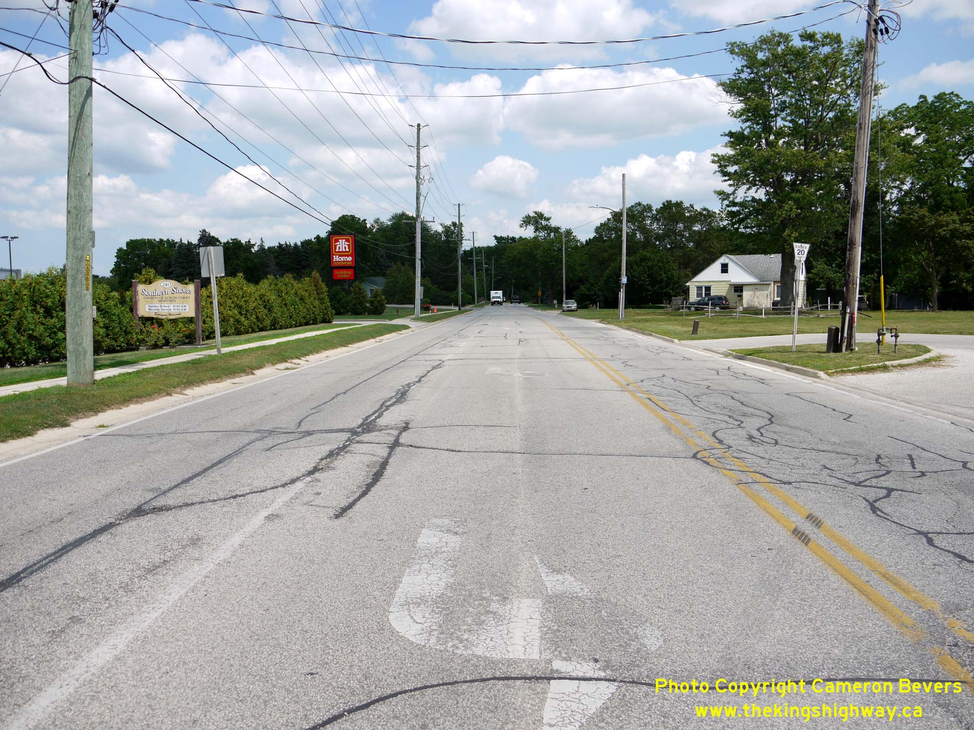
Above - Approaching Kingsville from the Former Hwy 18A Junction at the western entrance to town. From 1938 until 1961, Hwy 18A intersected with Hwy 18
approximately 1/2 mile east of here at the intersection of Main Street & Queen Street. See an
Enlarged Photo Here. (Photograph taken on August 2, 2019 - © Cameron Bevers)
More King's Highway 18A Photographs Coming Soon!
|
|---|
Links to Adjacent King's Highway Photograph Pages:
Back to King's Highway 18 Photos /
King's Highway 18A History /
On to King's Highway 19 Photos
Ontario Highway History - Main Menu / Back to List of Highways Website contents, photos & text © 2002-2026, Cameron
Bevers (Webmaster) - All Rights Reserved / Contact Me
|
|---|