
| 
| |
|
|
This page contains historical and present day photos of Ontario's King's Highway 22. All photographs displayed on this page
were taken by the Webmaster (Cameron Bevers), unless specifically noted otherwise. Historical photographs are arranged in approximate chronological order, while
present day photographs (Year 2000 to date) are arranged by location from west to east. Click on any thumbnail to see a larger image!
Please note that all photographs displayed on this
website are protected by copyright. These photographs must not be reproduced, published,
electronically stored or copied, distributed, or posted onto other websites without
my written permission. If you want to use photos from this website, please
email me first for permission. Thank-you!
|
|---|
|
Historical King's Highway 22 Photographs

Above - View of Dundas Street (Hwy 2) in Downtown London, facing west towards the Hwy 4 & Hwy 22 Junction at Clarence Street. See an
Enlarged Photo Here. Photo taken in 1951. (Photo courtesy of Ontario Department of Travel and Publicity - © King's Printer for Ontario, 1951) |
|---|
|
Present Day King's Highway 22 Photographs


Left - Facing west along Old Hwy 22 approaching the Hwy 79 Junction in Watford. Note the large corner diversion at right, which actually served as the through
route for Hwy 22 up until 1947. The superelevated 717-foot radius curve was designed to allow for faster through traffic on Old Hwy 22. The curve diversion at Watford
was built in the early 1930s, in order to bypass an intersection on the original highway's route. See an
Enlarged Photo Here. (Photograph taken on May 4, 2009 - © Cameron Bevers) Right - This corner diversion was built in 1933 to carry through traffic between London and Sarnia. The diversion bypassed a former turn in the route of Hwy 22 located at the north end of Watford. Although this corner diversion once carried both eastbound and westbound traffic, it was re-striped many years ago to permit only westbound traffic bound for northbound Hwy 79. See an Enlarged Photo Here. (Photograph taken on May 4, 2009 - © Cameron Bevers) 

Left - Before the construction of the Watford Diversion in 1933, westbound traffic on Hwy 22 continued through to the stop sign where the highway turned right
onto Watford's Main Street (Hwy 79). See an Enlarged Photo Here. (Photograph taken on May 4, 2009 - © Cameron Bevers) Right - Facing east along Old Hwy 22 towards Strathroy from the Watford Diversion at the Hwy 79 Junction. This former provincial highway alignment carried Hwy 22 traffic from 1927 up until 1947, when a new route was established for Hwy 22 between Hickory Corners and Hwy 7 north of Watford. As a result of the relocation, the highway distance between Sarnia and London was shortened by approximately 8 km. The old route of Hwy 22 via Watford and Strathroy was transferred to Middlesex and Lambton Counties in 1947. See an Enlarged Photo Here. (Photograph taken on May 4, 2009 - © Cameron Bevers) 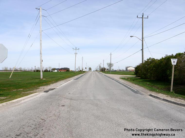

Left - Facing east along Old Hwy 22 (now Lambton Road 39) towards Strathroy from the Hwy 79 Junction in Watford. See an
Enlarged Photo Here. (Photograph taken on May 4, 2009 - © Cameron Bevers) Right - End of the Watford Diversion on Old Hwy 22, facing north along Hwy 79. See an Enlarged Photo Here. (Photograph taken on May 4, 2009 - © Cameron Bevers) 

Left - A gas station was built within the traffic island created during construction of the Watford Diversion in the 1930s. The fact that the gas pumps are
situated on the Watford Diversion (Old Hwy 22) side of the island suggests that this gas station has been in operation since before 1947. Had the gas station been
established after 1947 (when Hwy 22 was relocated onto a new route), the gas pumps would have likely been located on the Hwy 79 side of the traffic island. See an
Enlarged Photo Here. (Photograph taken on May 4, 2009 - © Cameron Bevers) Right - A pair of "Do Not Enter" signs have been placed at the end of the Watford Diversion (Old Hwy 22) to discourage traffic from short-cutting down the one-way ramp from southbound Hwy 79. A portion of the original Hwy 22 pavement was removed at the island's bullnose to remove any traces of the former through highway. See an Enlarged Photo Here. (Photograph taken on May 4, 2009 - © Cameron Bevers) 

Left - Facing north along Hwy 79 from the Old Hwy 22 Junction in Watford. Up until 1947, this section of Hwy 79 north of Watford was actually a part of Hwy 22.
During 1947, Hwy 22 was relocated onto a new alignment between the Hwy 7 Junction near Watford and Hickory Corners, allowing through traffic between London and Sarnia
to bypass Strathroy and Watford. Even today, the control city on northbound Hwy 79 is listed as Sarnia, which serves as a hint that historically Hwy 22 once passed
through Watford. See an Enlarged Photo Here. (Photograph taken on May 4, 2009 - © Cameron Bevers) Right - Facing south along Hwy 79 towards the Old Hwy 22 Junction in Watford. The end of the Watford Diversion can be seen emerging beside the gas station on the left. From this intersection, Hwy 79 continues south through Downtown Watford towards Bothwell in the Chatham area. See an Enlarged Photo Here. (Photograph taken on May 4, 2009 - © Cameron Bevers) 

Left - Northern side of the Sydenham River Bridge on Albert Street (Old Hwy 22) in Strathroy. See an
Enlarged Photo Here. (Photograph taken on April 15, 2006 - © Cameron Bevers) Right - Facing east along Albert Street (Old Hwy 22) towards Downtown Strathroy at the Sydenham River Bridge. This steel truss structure was completed in 1938. See an Enlarged Photo Here. (Photograph taken on April 15, 2006 - © Cameron Bevers) 

Left - The Sydenham River Bridge on Old Hwy 22 was built by the Department of Highways of Ontario (DHO) after a severe spring flood in 1937 damaged the old
Albert Street Bridge. The 1937 flood damaged many provincial highway bridges in the London Area. See an
Enlarged Photo Here. (Photograph taken on April 15, 2006 - © Cameron Bevers) Right - The Albert Street Bridge over the Sydenham River in Strathroy is a steel pony truss structure. Many of these arched pony truss bridges were built on Ontario's King's Highways during the 1930s, 1940s and 1950s. This Warren-type truss structure on Old Hwy 22 consists of a single 98-foot span. See an Enlarged Photo Here. (Photograph taken on April 15, 2006 - © Cameron Bevers) 

Left - A cantilevered sidewalk was built along the northern side of the Sydenham River Bridge on Old Hwy 22 (Albert Street) in Strathroy. See an
Enlarged Photo Here. (Photograph taken on April 15, 2006 - © Cameron Bevers) Right - These steel lattice railings on the Sydenham River Bridge were typical of many DHO-built steel bridges constructed in the 1920s and 1930s. See an Enlarged Photo Here. (Photograph taken on April 15, 2006 - © Cameron Bevers) 

Left - The Sydenham River Bridge in Strathroy carried Hwy 22 traffic for only 9 years, from the time of the bridge's completion in 1938 up until 1947. The
route of Hwy 22 was relocated onto a new alignment between Hickory Corners and Hwy 7 in 1947. See an
Enlarged Photo Here. (Photograph taken on April 15, 2006 - © Cameron Bevers) Right - The steel used for the Sydenham River Bridge on Old Hwy 22 was supplied by Algoma Steel. See an Enlarged Photo Here. (Photograph taken on April 15, 2006 - © Cameron Bevers) 

Left - The Sydenham River Bridge on Old Hwy 22 in Strathroy was constructed with three embossed ornamental stripes on the concrete balusters. This decorative
feature was a trademark of DHO-built bridges constructed in the 1930s and 1940s. Note the faded yellow-and-white hazard stripes painted onto the handrail. See an
Enlarged Photo Here. (Photograph taken on April 15, 2006 - © Cameron Bevers) Right - Facing west along the Poplar Hill Diversion on Hwy 22 at the Sydenham River Bridge. See an Enlarged Photo Here. (Photograph taken on April 15, 2006 - © Cameron Bevers) 

Left - Southern side of the Sydenham River Bridge on Hwy 22 at Poplar Hill. This single span pre-stressed concrete girder structure was completed in 1957. It
was among the first of this type of bridge design constructed on the King's Highways, during a time where the DHO was seeking alternative methods to cast-in-place
concrete bridge construction. See an Enlarged Photo Here. (Photograph taken on April 15, 2006 - © Cameron Bevers) Right - Close-up view of the pre-stressed concrete girders used on the Sydenham River Bridge on Hwy 22 at Poplar Hill. See an Enlarged Photo Here. (Photograph taken on April 15, 2006 - © Cameron Bevers) 

Left - Below-deck view of the Sydenham River Bridge on Hwy 22 at Poplar Hill. This was one of two pre-stressed concrete girder bridges built on Ontario's
Highways in 1957. The other bridge was located on Hwy 66 in the Kirkland Lake area. This experimental pre-stressed concrete girder bridge on Hwy 22 has fared
incredibly well against the elements, considering its age. See an Enlarged Photo Here. (Photograph taken on April 15, 2006 - © Cameron Bevers) Right - The Poplar Hill Bridge over the Sydenham River on Hwy 22 is comprised of a series of seven concave-shaped pre-stressed concrete girders. See an Enlarged Photo Here. (Photograph taken on April 15, 2006 - © Cameron Bevers) 

Left - Facing east along Hwy 22 towards London at the Sydenham River Bridge at Poplar Hill. See an
Enlarged Photo Here. (Photograph taken on April 15, 2006 - © Cameron Bevers) Right - The original Poplar Hill Bridge can be seen partially hidden in the forest along the northern side of Hwy 22, just downstream of the current Sydenham River Bridge. See an Enlarged Photo Here. (Photograph taken on April 15, 2006 - © Cameron Bevers) 

Left - This former alignment of Hwy 22 (Barclay Boulevard) at Poplar Hill was bypassed during the 1950s. See an
Enlarged Photo Here. (Photograph taken on April 15, 2006 - © Cameron Bevers) Right - The former Hwy 22 alignment at Poplar Hill leads into the forest. See an Enlarged Photo Here. (Photograph taken on April 15, 2006 - © Cameron Bevers) 

Left - An abandoned steel truss bridge across the Sydenham River still stands on the former Hwy 22 alignment at Poplar Hill. The bridge has been closed off to
through traffic since 1957, when the Poplar Hill diversion was completed bypassing the old bridge. See an
Enlarged Photo Here. (Photograph taken on April 15, 2006 - © Cameron Bevers) Right - Facing west towards Poplar Hill on the former alignment of Hwy 22 (Barclay Boulevard) from the abandoned Sydenham River Bridge. See an Enlarged Photo Here. (Photograph taken on April 15, 2006 - © Cameron Bevers) 

Left - The old Hwy 22 bridge over the Sydenham River is a Warren Truss design. See an
Enlarged Photo Here. (Photograph taken on April 15, 2006 - © Cameron Bevers) Right - Southern side of the abandoned Poplar Hill Bridge on Hwy 22. See an Enlarged Photo Here. (Photograph taken on April 15, 2006 - © Cameron Bevers) 

Left - Northern side of the old Sydenham River Bridge on Hwy 22 at Poplar Hill. See an
Enlarged Photo Here. (Photograph taken on April 15, 2006 - © Cameron Bevers) Right - The abandoned Hwy 22 alignment continues through the forest, and eventually emerges beside the current highway. See an Enlarged Photo Here. (Photograph taken on April 15, 2006 - © Cameron Bevers) 

Left - Deck view of the abandoned Sydenham River Bridge on Hwy 22. See an
Enlarged Photo Here. (Photograph taken on April 15, 2006 - © Cameron Bevers) Right - The Poplar Hill Bridge dates from about 1920. It was constructed by the County of Middlesex, years before Hwy 22 was designated as a provincial highway in 1927. This is why this steel truss bridge differs slightly from the standard DHO truss bridge design that was commonly used in the early 1920s. See an Enlarged Photo Here. (Photograph taken on April 15, 2006 - © Cameron Bevers) 

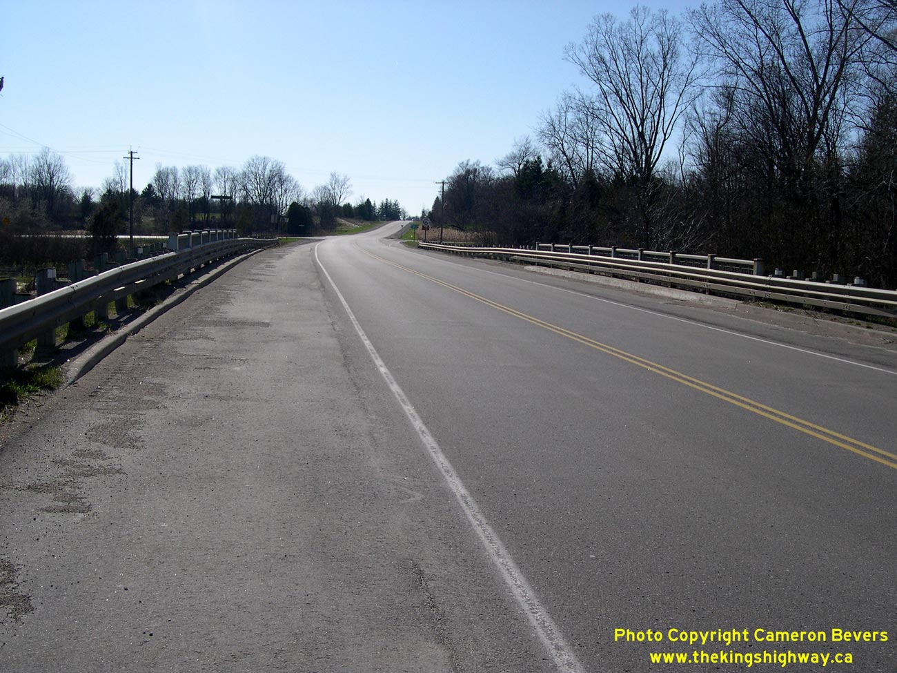
Left - Oxbow Creek Bridge on Hwy 22 west of London. Structure completed in 1958. See an
Enlarged Photo Here. (Photograph taken on April 15, 2006 - © Cameron Bevers) Right - Facing east along Hwy 22 towards London at the Oxbow Creek Bridge. See an Enlarged Photo Here. (Photograph taken on April 15, 2006 - © Cameron Bevers) 

Left - Southern side of the Oxbow Creek Bridge on Hwy 22. See an
Enlarged Photo Here. (Photograph taken on April 15, 2006 - © Cameron Bevers) Right - Below-deck view of the Oxbow Creek Bridge. See an Enlarged Photo Here. (Photograph taken on April 15, 2006 - © Cameron Bevers) 

Left - Northern side of the Oxbow Creek Bridge on Hwy 22. See an
Enlarged Photo Here. (Photograph taken on April 15, 2006 - © Cameron Bevers) Right - Facing west along Hwy 22 towards Sarnia at the Oxbow Creek Bridge. See an Enlarged Photo Here. (Photograph taken on April 15, 2006 - © Cameron Bevers) 
Above - Close-up view of the concrete and steel handrail design of the Oxbow Creek Bridge on Hwy 22. See an
Enlarged Photo Here. (Photograph taken on April 15, 2006 - © Cameron Bevers) 
Above - An old Hwy 22 sign at a junction just west of London. See an
Enlarged Photo Here. (Photograph taken in October, 2002 - © Cameron Bevers)
More King's Highway 22 Photographs Coming Soon!
|
|---|
Links to Adjacent King's Highway Photograph Pages:
Back to King's Highway 21 Photos /
King's Highway 22 History /
On to King's Highway 23 Photos
Ontario Highway History - Main Menu / Back to List of Highways Website contents, photos & text © 2002-2026, Cameron
Bevers (Webmaster) - All Rights Reserved / Contact Me
|
|---|