| 
|  |
|
|
This page contains historical and present day photos of Ontario's King's Highway 40A. All photographs displayed on this page
were taken by the Webmaster (Cameron Bevers), unless specifically noted otherwise. Historical photographs are arranged in approximate chronological order, while
present day photographs (Year 2000 to date) are arranged by location from south to north. Click on any thumbnail to see a larger image!
Please note that all photographs displayed on this
website are protected by copyright. These photographs must not be reproduced, published,
electronically stored or copied, distributed, or posted onto other websites without
my written permission. If you want to use photos from this website, please
email me first for permission. Thank-you!
|
|---|
|
Historical King's Highway 40A Photographs

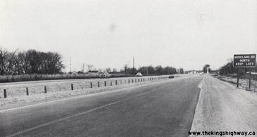
Above - Resurfaced section of Hwy 402 approaching Modeland Road east of Sarnia in 1959. At the time this photo was taken, Modeland Road met Hwy 402 at an
at-grade intersection. When the Bluewater Bridge Approach (Hwy 402) was first built through Sarnia in the 1940s, it was designed as a four-lane divided highway with
limited access. A grade-separated interchange was built at Christina Street, but all other intersections along the initial route of Hwy 402 through Sarnia were left
at-grade. It took many years to fully convert Hwy 402 into a controlled-access freeway through Sarnia. An interchange was built at Modeland Road (Hwy 40) on a
slightly realigned route of Hwy 402 in 1975-1976. Photo taken in 1959. (Photo courtesy of Ontario Ministry of Transportation - © King's Printer for Ontario, 1959) 
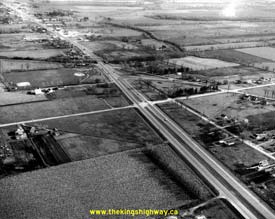
Above - Junction of Hwy 402 and Modeland Road (Lucasville Road) east of Sarnia in 1962. This aerial photo of Hwy 402 shows the junction of Modeland Road and the
adjacent Hwy 7 junction, just east of Sarnia (facing east). Modeland Road was later incorporated into the Sarnia Bypass and was designated as Hwy 40 in the mid-1960s.
The at-grade intersection at Hwy 402 was eventually eliminated through the construction of a proper interchange at Hwy 40. In the 1970s, Hwy 402 was extended easterly
from Sarnia towards London and was realigned through the area in the bottom left corner of the photo. The Hwy 402 connection to Hwy 7 seen here was subsequently
removed and is now the site of a shopping plaza. Sarnia's present day "Golden Mile" can be seen along Hwy 7 in the top left corner of this photo. See
an Enlarged Photo Here. Photo taken on November 28, 1962. (Photo © Archives of Ontario - Series RG-14-151-7-16, Photo #3851) 
Above - Construction progress on the Modeland Road (Hwy 40) Interchange on Hwy 402 in Sarnia (1976) (Photo courtesy of Ontario Ministry of Transportation - © King's Printer for Ontario, 1976)
More King's Highway 40A Photographs Coming Soon!
|
|---|
Links to Adjacent King's Highway Photograph Pages:
Back to King's Highway 40 Photos /
King's Highway 40A History /
On to King's Highway 41 Photos
Ontario Highway History - Main Menu / Back to List of Highways Website contents, photos & text © 2002-2025, Cameron
Bevers (Webmaster) - All Rights Reserved / Contact Me |
|---|