
| 
|  |
|
|
This page contains present day photos (Year 2000 to date) of Ontario's King's Highway 5, arranged by location from
Waterdown easterly to Toronto. All photographs displayed on this page were taken by the Webmaster (Cameron Bevers), unless specifically noted otherwise. Click on
any thumbnail to see a larger image!
Please note that all photographs displayed on this
website are protected by copyright. These photographs must not be reproduced, published,
electronically stored or copied, distributed, or posted onto other websites without
my written permission. If you want to use photos from this website, please
email me first for permission. Thank-you!
|
|---|
|
Page 3: Present Day King's Highway 5 Photographs (Waterdown to Toronto)
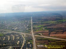
Above - Aerial view of the Hwy 407 ETR and Hwy 5 (Dundas Street) Interchange in Burlington, facing west. See an
Enlarged Photo here. (Photograph taken on November 3, 2006 - © Cameron Bevers) 

Left - Aerial view of the Hwy 407 ETR and Hwy 5 (Dundas Street) Interchange in Burlington, facing northwest. See an
Enlarged Photo here. (Photograph taken on November 3, 2006 - © Cameron Bevers) Right - Aerial view of the Hwy 407 ETR and Hwy 5 (Dundas Street) Interchange in Burlington, facing south. See an Enlarged Photo here. (Photograph taken on November 3, 2006 - © Cameron Bevers) 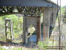
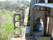
Left - The Tansley Bridge over Bronte Creek on Hwy 5 clearly illustrates the growing importance of Ontario's highway system over the past century. The first
high-level bridge across Bronte Creek was completed in 1919, before Dundas Street had even been designated as a provincial highway. The concrete piers of the original
1919 structure can be seen at left. In 1946, construction began on a new high-level bridge over Bronte Creek, to replace the narrow 1919 structure. The new
Warren-type steel deck truss replacement structure (at centre) was completed in 1948. The Bronte Creek Bridge at Tansley was expanded in the 1970s to accommodate a
widened Hwy 5. The continuous steel girder structure at right was completed in 1979. Ironically, the replaced 1919 structure at left was originally a replacement
bridge as well. Prior to 1919, Dundas Street crossed a low-level steel truss bridge at the bottom of the valley. It was built around 1885, but it was decided
during World War I to take the low-level bridge out of service. The road alignment leading to the valley floor was crooked and narrow, and was therefore not very
suitable for motorized traffic. (Photograph taken on May 11, 2003 - © Cameron Bevers) Right - Close-up of the old 1919 highway bridge piers looking west along Hwy 5 at Tansley (Bronte Creek). Construction of the first high-level bridge at Tansley began during World War I in 1916. Dogged by material, equipment and personnel shortages, the bridge project at Tansley was very slow to progress. Construction of the new high-level bridge over Bronte Creek was eventually taken over by the County of Halton after Dundas Street was designated as a county road. The deck truss superstructure was erected in 1918, using wrought iron manufactured in England for the Intercolonial Railroad. Following the completion of the new structure at Tansley in 1948, the wrought iron superstructure of the first high-level bridge was removed, leaving behind only the concrete abutments and piers. (Photograph taken on May 11, 2003 - © Cameron Bevers) 
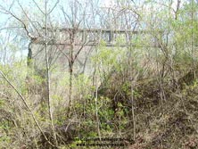
Left - View of the 1948 (Eastbound) and the 1979 (Westbound) structures over Bronte Creek on Hwy 5 at Tansley. The structure consists of two 200 foot spans and
two 150 foot spans, for a total bridge length of 700 feet. (Photograph taken on May 11, 2003 - © Cameron Bevers) Right - Overgrown remains of the western approach to the former 1919 structure over Bronte Creek on Hwy 5 at Tansley. (Photograph taken on May 11, 2003 - © Cameron Bevers) 

Left - View of the 1919 highway bridge piers at Tansley (Bronte Creek), facing east towards Toronto. Construction of the new bridge at Tansley was started
in 1916, but wasn't completed until 1919. This structure was originally under the jurisdiction of the County of Halton, but ownership of the bridge was transferred
to the Department of Public Highways when Dundas Street was assumed as a new provincial highway in July, 1920. The two later structures (at left) were built by the
province in 1948 and 1979. (Photograph taken on May 11, 2003 - © Cameron Bevers) Right - Aerial view of the Sixteen Mile Creek Bridge on Hwy 5 (Dundas Street) in Oakville, facing east towards Toronto. See an Enlarged Photo here. (Photograph taken on November 14, 2005 - © Cameron Bevers) 
Left - Aerial view of the Sixteen Mile Creek Bridge on Hwy 5 (Dundas Street) in Oakville, facing northeast. This massive steel deck truss structure was built in 1960,
replacing an older two-lane structure that had been built by the Department of Public Highways in 1921. The structure seen here was demolished when new twin
structures were built across the Sixteen Mile Creek Valley during an ambitious multi-year reconstruction project which took place between 2008 and 2011. See an
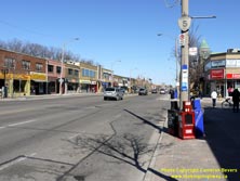
Enlarged Photo here. (Photograph taken on November 14, 2005 - © Cameron Bevers) Right - An older King's Highway 5 route marker on Bloor Street in Toronto, near Brentwood Boulevard. See an Enlarged Photo here. (Photograph taken on April 12, 2009 - © Cameron Bevers) 

Left - Humber River Bridge on Hwy 5 (Bloor Street) in Toronto. Structure completed in 1924. Although this is a multi-span steel deck arch bridge, only one arch
span crosses the Humber River itself. The other three arch spans leap across the broad valley floor. See an
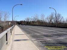
Enlarged Photo here. (Photograph taken on April 12, 2009 - © Cameron Bevers) Right - Facing east along Hwy 5 (Bloor Street) at the Humber River Bridge in Toronto. See an Enlarged Photo here. (Photograph taken on April 12, 2009 - © Cameron Bevers) 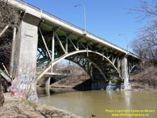
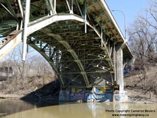
Left - The Humber River Bridge on Hwy 5 is a steel Pratt truss deck arch structure. This was the very first steel arch bridge ever built by the Department of
Highways. At the time of its construction in 1924, the Humber River Bridge was the second-longest structure ever built by the Department of Highways, with a total
length of 745 feet. Surprisingly few steel arch bridges were ever built in Ontario by the Department of Highways, so bridges of this design are quite rare on the
province's highways. Sadly, the attractive deck arch design is not apparent for motorists or pedestrians using Bloor Street. See an
Enlarged Photo here. (Photograph taken on April 12, 2009 - © Cameron Bevers) Right - Precious few steel deck arch structures were built on Ontario's Highways. Following the completion of the Humber River Bridge in 1924, the use of this steel deck arch truss design was temporarily retired until the 1930s, when two new steel deck arch bridges were constructed on the King's Highways. The first was built across the Grand River on Hwy 2 in Paris in 1931, while the other was built on Hwy 17 across Keewatin Channel near Kenora in 1938. See an Enlarged Photo here. (Photograph taken on April 12, 2009 - © Cameron Bevers) 

Left - View underneath the Humber River Bridge on Hwy 5 (Bloor Street) in Toronto. This was
one of the only bridges crossing the Humber River in the Toronto area that sustained almost no long-term damage from the devastating flood in the Humber Valley caused
by Hurricane Hazel in October, 1954. By comparison, the brand new bridge built to carry the Toronto Bypass (Hwy 401) across the Humber River was so badly damaged by
the Hurricane Hazel Flood that the unopened highway bridge had to be demolished and rebuilt entirely. See an
Enlarged Photo here. (Photograph taken on April 12, 2009 - © Cameron Bevers) Right - Northern side of the Humber River Bridge on Hwy 5 (Bloor Street) in Toronto. This elaborate structure consists of four main deck arch spans and two "half-arch" approach spans supported on concrete pedestals. As originally designed, the Humber River Bridge had a bridge deck that was 60 feet in width. See an Enlarged Photo here. (Photograph taken on April 12, 2009 - © Cameron Bevers) 
Left - The arches of the Humber River Bridge on Hwy 5 (Bloor Street) were designed with a hinged connection at the top of each arch, to allow for a slight
movement of the bridge as the steel expands and contracts with changes in the ambient temperature. See an
Enlarged Photo here. (Photograph taken on April 12, 2009 - © Cameron Bevers) Right - A pair of expansion joints on the bridge deck indicate just how large the piers of the Humber River Bridge on Hwy 5 actually are. See an Enlarged Photo here. (Photograph taken on April 12, 2009 - © Cameron Bevers) 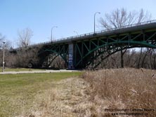

Left - The Humber River Bridge underwent an extensive rehabilitation in 2010-2011, which will ensure an extended life span for this interesting early
Department of Highways' built structure. Since the entire bridge lies within a city park with well-established roads and trails along the valley floor, it is among
the easiest of Ontario's historic bridges to admire. See an Enlarged Photo here. (Photograph taken on April 12, 2009 - © Cameron Bevers) Right - At the time of the Humber River Bridge's construction in the 1920s, the bridge acted as a grand western gateway to the City of Toronto. For traffic approaching Toronto on Hwy 5, it would have been the first significant built-up area encountered since departing Waterdown, located almost 50 km to the west. The massive cities of Mississauga, Oakville and Burlington that we know today didn't exist. Only a few small rural hamlets existed along the route of Hwy 5 between Waterdown and Toronto. As the city continued to expand westerly towards present-day Burlington, the once-important Hwy 5 became little more than just another city street. Although it remains as a very impressive and rare piece of early Department of Highways' built infrastructure, the Humber River Bridge no longer acts as a "gateway feature" at the entrance to the city as it once did - in fact, the bridge is now entirely surrounded by the city. See an Enlarged Photo here. (Photograph taken on April 12, 2009 - © Cameron Bevers) 
Above - Facing west along Hwy 5 (Bloor Street) at the Humber River Bridge in Toronto. The completion of the new high-level bridge at Humber River in 1924 was
the final stage in completing a modern highway between Toronto and Hamilton, via Dundas Street. The new bridge and diversion at Humber River allowed inter-city
traffic to bypass the old, winding section of the provincial highway that previously existed at Humber River. See an
Enlarged Photo here. (Photograph taken on April 12, 2009 - © Cameron Bevers)
More King's Highway 5 Photographs Coming Soon!
|
|---|
Links to Adjacent King's Highway Photograph Pages:
Back to King's Highway 4 Photos /
King's Highway 5 History /
On to King's Highway 6 Photos
Ontario Highway History - Main Menu / Back to List of Highways Website contents, photos & text © 2002-2025, Cameron
Bevers (Webmaster) - All Rights Reserved / Contact Me |
|---|