
| 
| |
|
|
This page contains photographs of British Columbia's Highway 3 (Crowsnest Highway), arranged by location from Princeton
westerly to Hope. All photographs displayed on this page were taken by the Webmaster (Cameron Bevers). To view photos of other British Columbia Highways, please
select a highway number listed on the British Columbia Photograph Index Page. Click on any
thumbnail to see a larger image!
Please note that all photographs displayed on this website are protected by copyright. These photographs must not be
reproduced, published, electronically stored or copied, distributed, or posted onto other websites without my written permission. If you want to use photos from this
website, please email me first for permission. Thank-you!
|
|---|
|
Page 10: BC Highway 3 (Crowsnest Highway) Photographs: Princeton to Hope


Left - Facing west along the Crowsnest Highway (Hwy 3) from the Hwy 5A Junction in Princeton. See an
Enlarged Photo Here. (Photograph taken on June 9, 2015 - © Cameron Bevers) Right - Changeable message sign on westbound Hwy 3 departing Princeton. See an Enlarged Photo Here. (Photograph taken on June 9, 2015 - © Cameron Bevers) 

Left - Facing east along Hwy 3 approaching Princeton. For eastbound traffic, Princeton is the first major town along Hwy 3 since Hope. The Crowsnest Highway
passes through the Cascade Mountains between Princeton and Hope, which is a very sparsely-populated region of British Columbia. See an
Enlarged Photo Here. (Photograph taken on June 9, 2015 - © Cameron Bevers) Right - Distance guide sign on westbound Hwy 3 departing Princeton. The small community of Eastgate in Manning Park does have a gas station, but it does not offer 24-hour services. The next 24-hour gas station is located in Hope, so motorists using the highway late at night are well-advised to fill up in Princeton. See an Enlarged Photo Here. (Photograph taken on June 9, 2015 - © Cameron Bevers) 

Left - This sweeping vista is located about 15 km west of Princeton on Hwy 3. This thickly-forested region has surprisingly few panoramic vistas. See an
Enlarged Photo Here. (Photograph taken on June 9, 2015 - © Cameron Bevers) Right - Highway safety sign on the westbound Crowsnest Highway (Hwy 3) west of Princeton. The highway from Hope to Princeton is commonly referred to as the "Hope-Princeton Highway", even though it forms a link in the much longer Crowsnest Highway system. The highway link between Hope and Princeton was constructed comparatively late during the 1940s, which is probably the reason that the name Hope-Princeton Highway is still widely used. See an Enlarged Photo Here. (Photograph taken on June 9, 2015 - © Cameron Bevers) 

Left - Sign marking Sunday Summit on Hwy 3, about 32 km west of Princeton. At an elevation of 1,282 m (4,205 feet) above sea level, Sunday Summit is the
second-highest elevation reached along the Crowsnest Highway between Hope and Princeton. See an
Enlarged Photo Here. (Photograph taken on June 9, 2015 - © Cameron Bevers) Right - Facing west along Hwy 3 towards Hope at Sunday Summit. See an Enlarged Photo Here. (Photograph taken on June 9, 2015 - © Cameron Bevers) 

Left - Sign on eastbound Hwy 3 marking Sunday Summit, located about 32 km east of Princeton. See an
Enlarged Photo Here. (Photograph taken on June 9, 2015 - © Cameron Bevers) Right - Distance guide sign on eastbound Hwy 3 at Sunday Summit. See an Enlarged Photo Here. (Photograph taken on June 9, 2015 - © Cameron Bevers) 

Left - Distance guide sign on westbound Hwy 3 at Sunday Summit. See an
Enlarged Photo Here. (Photograph taken on June 9, 2015 - © Cameron Bevers) Right - Sign near Eastgate marking the eastern entrance to E.C. Manning Provincial Park. This large provincial park spans both sides of Hwy 3 for the next 59 km. There are no fees or tolls charged to motorists using Hwy 3 to traverse the park. Fees are charged for some park activities, such as overnight camping. See an Enlarged Photo Here. (Photograph taken on June 9, 2015 - © Cameron Bevers) 

Left - Near the Blowdown Rest Area on Hwy 3, a spectacular late-evening view of Mount Winthrop appears on the horizon. This scenic snow-capped peak actually
lies across the Canada-United States Border in neighbouring Washington State. A section of Hwy 3 through E.C. Manning Provincial Park comes fairly close to the
border, although there are no roads crossing into the United States in this area. There are no roads crossing between Canada and the United States between the
Osoyoos area and the Abbotsford area. See an Enlarged Photo Here. (Photograph taken on June 9, 2015 - © Cameron Bevers) Right - An old wooden sign in E.C. Manning Provincial Park still refers to Hwy 3 as the Hope-Princeton Highway. The Hope-Princeton Highway officially opened to traffic on November 2, 1949, after decades of unsuccessful attempts to build a road through this rugged, mountainous region. See an Enlarged Photo Here. (Photograph taken on June 10, 2015 - © Cameron Bevers) 

Left - Approaching the Crowsnest Highway (Hwy 3) on Gibson Pass Road in Manning Park. See an
Enlarged Photo Here. (Photograph taken on June 10, 2015 - © Cameron Bevers) Right - Facing west along Hwy 3 towards Hope from Gibson Pass Road in the small community of Manning Park, located 66 km west of Princeton. See an Enlarged Photo Here. (Photograph taken on June 10, 2015 - © Cameron Bevers) 

Left - Facing east along Hwy 3 towards Princeton, approaching Gibson Pass Road in Manning Park. See an
Enlarged Photo Here. (Photograph taken on June 10, 2015 - © Cameron Bevers) Right - View of Hwy 3 near Allison Pass, located about 59 km east of Hope. A substantial section on Hwy 3 through E.C. Manning Provincial Park was widened to a four-lane undivided highway. The four-lane section of Hwy 3 between Allison Pass and Eastgate is about 29 km in length. See an Enlarged Photo Here. (Photograph taken on June 10, 2015 - © Cameron Bevers) 

Left - Approaching Allison Pass on Hwy 3, facing west towards Hope. The approach to Allison Pass looks comparatively tame when viewing the summit from the
east. See an Enlarged Photo Here. (Photograph taken on June 10, 2015 - © Cameron Bevers) Right - Facing west along Hwy 3 towards Hope at Allison Pass. This summit lies in the Cascade Mountains, about 57 km east of Hope. See an Enlarged Photo Here. (Photograph taken on June 10, 2015 - © Cameron Bevers) 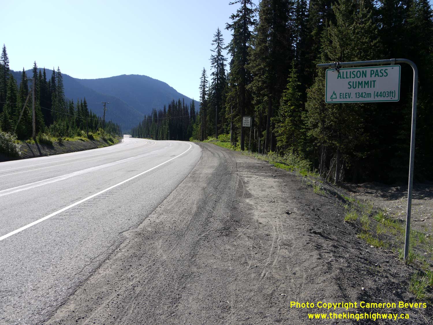

Left - Sign marking Allison Pass on eastbound Hwy 3. At 1,342 metres (4,403 feet) above sea level, Allison Pass is the highest pass along the Crowsnest
Highway in Western British Columbia. From Allison Pass, Hwy 3 quickly drops in elevation. By the time the highway reaches its western terminus in Hope, 58 km to the
west, the highway is only about 40 metres (130 feet) above sea level. See an
Enlarged Photo Here. (Photograph taken on June 10, 2015 - © Cameron Bevers) Right - Avalanche closure gates on Hwy 3 just west of Allison Pass. The western side of the pass has many steep slopes and is therefore more prone to avalanches. See an Enlarged Photo Here. (Photograph taken on June 10, 2015 - © Cameron Bevers) 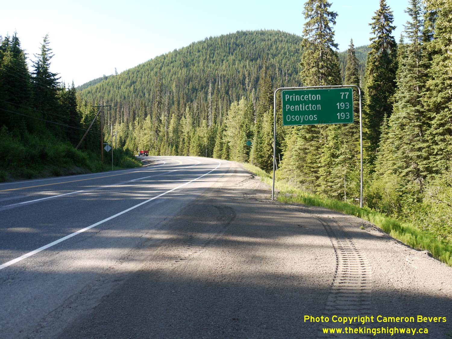

Left - Distance guide sign on the eastbound Crowsnest Highway (Hwy 3) near Allison Pass. See an
Enlarged Photo Here. (Photograph taken on June 10, 2015 - © Cameron Bevers) Right - Reverse curve on Hwy 3, looking west about 5 km west of Allison Pass. See an Enlarged Photo Here. (Photograph taken on June 10, 2015 - © Cameron Bevers) 

Left - Distance guide sign on westbound Hwy 3, about 17 km west of Allison Pass. See an
Enlarged Photo Here. (Photograph taken on June 10, 2015 - © Cameron Bevers) Right - Hwy 3 winds its way down into a deep canyon cut by the adjacent Skagit River. Hwy 3 has a steep and winding grade for the next several kilometres. Traces of snow can still be seen at the rocky summit of Marmot Mountain in the background. See an Enlarged Photo Here. (Photograph taken on June 10, 2015 - © Cameron Bevers) 
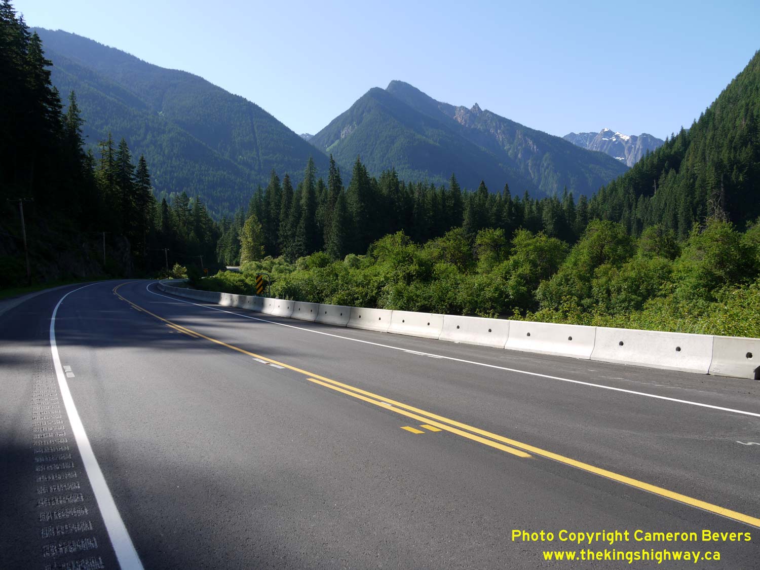
Left - Facing east along Hwy 3 towards Princeton, about 19 km west of Allison Pass. Hwy 3 clings to the side of the canyon wall on its breathtaking climb up
towards Allison Pass. With no shoulders and few turnouts, it is also a very difficult section of road to capture in a photograph. See an
Enlarged Photo Here. (Photograph taken on June 10, 2015 - © Cameron Bevers) Right - Once at the bottom of the Skagit Canyon Grade, the height of the some of the mountains of E.C. Manning Provincial Park become apparent. This view of Hwy 3 is just outside of Sumallo Grove, located about 34 km east of Hope. See an Enlarged Photo Here. (Photograph taken on June 10, 2015 - © Cameron Bevers) 

Left - Hwy 3 flattens out considerably once it reaches the valley floor. This view is facing west towards Hope from Sumallo Grove. See an
Enlarged Photo Here. (Photograph taken on June 10, 2015 - © Cameron Bevers) Right - Facing east along Hwy 3 towards Princeton from the western entrance to E.C. Manning Provincial Park. See an Enlarged Photo Here. (Photograph taken on June 10, 2015 - © Cameron Bevers) 

Left - Sign on Hwy 3 marking the western entrance to E.C. Manning Provincial Park. The park entrance is located about 24 km east of Hope. See an
Enlarged Photo Here. (Photograph taken on June 10, 2015 - © Cameron Bevers) Right - Facing west along Hwy 3 from the western entrance to E.C. Manning Provincial Park. From the park gate westerly to Hope, Hwy 3 is a four-lane highway. See an Enlarged Photo Here. (Photograph taken on June 10, 2015 - © Cameron Bevers) 

Left - Facing east along Hwy 3 towards Princeton from Sunshine Valley, located about 3 km west of the western entrance to E.C. Manning Provincial Park. See an
Enlarged Photo Here. (Photograph taken on June 10, 2015 - © Cameron Bevers) Right - Start of the Hope Slide Diversion on Hwy 3, approaching Sunshine Valley. In 1965, a dramatic rock slide near Sunshine Valley buried a portion of the Hope-Princeton Highway. A 5 km section of Hwy 3 had to be relocated onto a new alignment to bypass the section of the old highway cut off by the slide. See an Enlarged Photo Here. (Photograph taken on June 10, 2015 - © Cameron Bevers) 

Left - Facing east along Hwy 3 towards Princeton approaching Sunshine Valley. This small resort community is located about 20 km east of Hope. See an
Enlarged Photo Here. (Photograph taken on June 10, 2015 - © Cameron Bevers) Right - Facing east along Hwy 3 from the Hope Slide Lookout Entrance. The rock slide dramatically changed the elevation of the valley. In the area of the Hope Slide Lookout, the ground elevation was raised by about 55 metres (180 feet). See an Enlarged Photo Here. (Photograph taken on June 10, 2015 - © Cameron Bevers) 

Left - View of the Hope Slide from the current alignment of the Crowsnest Highway (Hwy 3). An earthquake is believed to have triggered the slide, which
resulted in huge pieces of rock breaking off of Mount Johnson and crashing down into the valley below. About 3 km of the old Hope-Princeton Highway was buried by the
Hope Slide. See an Enlarged Photo Here. (Photograph taken on June 10, 2015 - © Cameron Bevers) Right - The old Hope-Princeton Highway lies buried below almost 200 feet of rock which broke free from a nearby mountain on the morning of January 9, 1965. Four lives were lost in the disaster. The site has a rather haunted feeling to it, as some of the slide victims were never recovered. See an Enlarged Photo Here. (Photograph taken on June 10, 2015 - © Cameron Bevers) 

Left - Interpretive panel at the Hope Slide Lookout on Hwy 3. Coincidentally, another one of Canada's historical rock slide disasters occurred in a town
adjacent to the Crowsnest Highway in neighbouring Alberta in the early 1900s. In 1903, the town of Frank, Alberta was partially buried by a rock slide. The debris
field from the Frank Slide can still be seen today from the present-day Crowsnest Highway. See an
Enlarged Photo Here. (Photograph taken on June 10, 2015 - © Cameron Bevers) Right - Facing west along Hwy 3, about 1 km west of the Hope Slide Lookout. See an Enlarged Photo Here. (Photograph taken on June 10, 2015 - © Cameron Bevers) 

Left - Advance guide sign on the westbound Crowsnest Highway (Hwy 3) marking the upcoming Hwy 5 (Coquihalla Highway) Interchange near Hope. The Coquihalla
Highway is part of the Yellowhead Highway System and is signed using special Yellowhead Highway route markers. See an
Enlarged Photo Here. (Photograph taken on June 10, 2015 - © Cameron Bevers) Right - Sign warning drivers of Long Combination Vehicles (LCVs) using the Trans-Canada Highway (Hwy 1) and the Coquihalla Highway (Hwy 5). Although the practice of towing two 53-foot trailers behind a single tractor unit is very efficient for motor carriers, they can also represent a traffic hazard. It isn't apparent to motorists following behind an LCV that they are in fact following behind a tractor unit towing two trailers. Motorists may misjudge the time needed to pass an LCV, particularly on a two-lane highway when the passing manoeuvre is done in the opposing traffic lane. On multi-lane highways, the presence of LCVs in the traffic stream is somewhat less of a problem, since passing is done in a lane travelling in the same direction as the LCV. See an Enlarged Photo Here. (Photograph taken on June 10, 2015 - © Cameron Bevers) 

Left - Facing west along the Crowsnest Highway (Hwy 3), about 1 km east of the Hwy 5 Interchange. See an
Enlarged Photo Here. (Photograph taken on June 10, 2015 - © Cameron Bevers) Right - Facing east along the Crowsnest Highway (Hwy 3) near the Hwy 5 Interchange. Note the sign at right, advising motorists that there are no services along the highway for the next 75 km. After travelling through BC's heavily-developed Lower Mainland region, the sudden remoteness of the Cascade Mountains likely catches some motorists off-guard. See an Enlarged Photo Here. (Photograph taken on June 10, 2015 - © Cameron Bevers) 

Left - Facing west along the Crowsnest Highway (Hwy 3) towards the Hwy 5 Interchange. Hwy 3 & Hwy 5 connect about 7 km east of Hope. A median barrier
begins here. See an Enlarged Photo Here. (Photograph taken on June 10, 2015 - © Cameron Bevers) Right - Sign marking the beginning of the freeway on the westbound Crowsnest Highway (Hwy 3). From this point westerly to Hope, Hwy 3 is a fully controlled-access highway. See an Enlarged Photo Here. (Photograph taken on June 10, 2015 - © Cameron Bevers) 

Left - Diagrammatic sign on the westbound Crowsnest Highway (Hwy 3) approaching the Coquihalla Highway (Hwy 5) Interchange. Two lanes continue west towards
Vancouver, while one lane exits north along Hwy 5 towards Merritt and Kamloops. Most traffic heads west from this interchange. Princeton-area motorists would
likely have used the much shorter route of Hwy 5A if their destination was either Merritt or Kamloops. See an
Enlarged Photo Here. (Photograph taken on June 10, 2015 - © Cameron Bevers) Right - Facing east along Hwy 3 towards Princeton from the Coquihalla Highway (Hwy 5) Interchange near Hope. See an Enlarged Photo Here. (Photograph taken on June 10, 2015 - © Cameron Bevers) 

Left - Facing west along Hwy 3 at the Coquihalla Highway (Hwy 5) Interchange near Hope. The ramp at right leads to Hwy 5 North to Merritt and Kamloops while
the two through lanes continue west towards Hope and the Trans-Canada Highway (Hwy 1). The ramps at the Hwy 3 & Hwy 5 Interchange are in a "Trumpet"
configuration. See an Enlarged Photo Here. (Photograph taken on June 10, 2015 - © Cameron Bevers) Right - Hope Mountain can be seen in the background as Hwy 3 & Hwy 5 part ways at the Coquihalla & Crowsnest Highway Junction near Hope. See an Enlarged Photo Here. (Photograph taken on June 10, 2015 - © Cameron Bevers) 

Left - Overhead guide sign on the southbound Coquihalla Highway (Hwy 5) approaching the Crowsnest Highway (Hwy 3) Interchange east of Hope. The exit to Hwy 3
East is located on a long curve and is not very conspicuous. See an
Enlarged Photo Here. (Photograph taken on June 10, 2015 - © Cameron Bevers) Right - Southern terminus of the Coquihalla Highway (Hwy 5) at the Hwy 3 Interchange. The exit ramp to Hwy 3 East can be seen exiting the freeway at right. The two through lanes merge with Hwy 3 West. The Crowsnest Highway (Hwy 3) only continues west for another 6 km before it too ends. Westbound traffic heading from Hope to Vancouver can follow either the Trans-Canada Highway (Hwy 1) or the less-direct Lougheed Highway (Hwy 7). See an Enlarged Photo Here. (Photograph taken on June 10, 2015 - © Cameron Bevers) 

Left - Facing west along the Crowsnest Highway (Hwy 3) from the Coquihalla Highway (Hwy 5) Interchange near Hope. See an
Enlarged Photo Here. (Photograph taken on June 10, 2015 - © Cameron Bevers) Right - Approaching the Hwy 3 & Hwy 5 Interchange near Hope, facing east. The Coquihalla Highway (Hwy 5) curves to the left and heads north towards Merritt and Kamloops. The Crowsnest Highway (Hwy 3) curves to the right and heads east towards Princeton and Osoyoos. See an Enlarged Photo Here. (Photograph taken on June 10, 2015 - © Cameron Bevers) 

Left - Overhead guide sign on eastbound Hwy 3 approaching the Coquihalla Highway (Hwy 5) Interchange east of Hope. The left lane continues to Hwy 5 North while
the right lane continues to Hwy 3 East. The centre eastbound lane can be used to access either highway. The Coquihalla Highway was completed between Hope and Merritt
as a toll highway during the 1980s. The new highway officially opened to traffic on May 16, 1986. Tolls were collected on the highway from 1986 until the Fall of 2008,
but it is now a toll-free highway. See an Enlarged Photo Here. (Photograph taken on June 10, 2015 - © Cameron Bevers) Right - The spectacular background scenery for this overhead sign approaching the Hwy 3 & Hwy 5 Interchange near Hope provides motorists with some clues of the type of terrain they are heading into. See an Enlarged Photo Here. (Photograph taken on June 10, 2015 - © Cameron Bevers) 

Left - Facing west along the Crowsnest Highway (Hwy 3) from the Coquihalla Highway (Hwy 5) Interchange. The freeway briefly widens from 4 to 6 lanes between
Hwy 5 and the Hope exit, since the two interchanges are fairly closely spaced. See an
Enlarged Photo Here. (Photograph taken on June 10, 2015 - © Cameron Bevers) Right - Approaching the Hope-Princeton Way exit on westbound Hwy 3. The exit is merely signed as "Hope". See an Enlarged Photo Here. (Photograph taken on June 10, 2015 - © Cameron Bevers) 

Left - A "Your Choice" tourism-oriented sign for Kelowna on eastbound Hwy 3 approaching the Coquihalla Highway (Hwy 5) Interchange. Signs such as this one are
placed in advance of strategic highway junction in British Columbia, to advise tourists of the alternate routes available to them to reach certain destinations. I
think these signs are a great way to encourage motor tourism on what would otherwise be less-travelled routes. See an
Enlarged Photo Here. (Photograph taken on June 10, 2015 - © Cameron Bevers) Right - Road closure notification sign on Hope-Princeton Way (Old Hwy 3) departing Hope. Hwy 3, Hwy 5 & Hwy 97C all cross relatively high-altitude mountain passes through the Cascade Mountains and are subject to periodic highway closures in the winter months. See an Enlarged Photo Here. (Photograph taken on June 10, 2015 - © Cameron Bevers) 

Left - An older distance guide sign for Manning Park on Hope-Princeton Way (Old Hwy 3) departing Hope. See an
Enlarged Photo Here. (Photograph taken on June 10, 2015 - © Cameron Bevers) Right - Facing east along Hope-Princeton Way (Old Hwy 3) departing Hope. A sign at right advises motorists of the distances to the next services along Hwy 3 (85 km away) and Hwy 5 (120 km away). The area east of Hope is very remote and mountainous. See an Enlarged Photo Here. (Photograph taken on June 10, 2015 - © Cameron Bevers) 

Left - Facing west along Hwy 3 towards Vancouver from the Hope-Princeton Way Interchange. This freeway section of Hwy 3 bypasses Hope altogether, and provides
a direct connection to the Trans-Canada Highway (Hwy 1). See an Enlarged Photo Here. (Photograph taken on June 10, 2015 - © Cameron Bevers) Right - Advance guide sign for the Trans-Canada Highway (Hwy 1) on westbound Hwy 3. The Crowsnest Highway (Hwy 3) ends at the Trans-Canada Highway in Hope. However, only traffic bound for Hwy 1 East has to exit the freeway. Westbound traffic on the freeway joins the route of Hwy 1 West from Hope to Vancouver. See an Enlarged Photo Here. (Photograph taken on June 10, 2015 - © Cameron Bevers) 

Left - Approaching the Hwy 1 Interchange on westbound Hwy 3 in Hope. The off-ramp to Hwy 1 East is visible at right. See an
Enlarged Photo Here. (Photograph taken on June 10, 2015 - © Cameron Bevers) Right - Facing west towards Vancouver at the western terminus of the Crowsnest Highway (Hwy 3) in Hope. Note the Hwy 3 Ends sign at right. The on-ramps from the Trans-Canada Highway (Hwy 1) merge onto the freeway just beyond the curve. Interestingly, the Crowsnest Highway also connects to the Trans-Canada Highway at the route's eastern terminus in Medicine Hat, Alberta. See an Enlarged Photo Here. (Photograph taken on June 10, 2015 - © Cameron Bevers)
Continue west towards Vancouver from Hope via BC Highway 1 |
|---|
Links to Adjacent BC Highway Photograph Pages:
Back to BC Highway 1 Photos /
British Columbia Highways Photo Index /
On to BC Highway 3A Photos
Ontario Highway History - Main Menu / Vacation Highway Photos - Main Menu Website contents, photos & text © 2002-2026, Cameron
Bevers (Webmaster) - All Rights Reserved / Contact Me
|
|---|