| 
| |
|
|
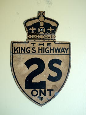
History of King's Highway 2S:
King's Highway 2S was a scenic parkway constructed through the Thousand Islands region between Gananoque and Butternut Bay, just west of Brockville during the late
1930s. The highway was built along the north shore of the St. Lawrence River and was intended as a scenic alternate route to the more inland route offered by
Highway 2 between Gananoque and Brockville. Highway 2S was the only route in Ontario to bear an "S" suffix, which, contrary to popular belief, stood for "Scenic" not
"South". The scenic parkway was one of Ontario's earliest divided highways. Highway 2S existed in one form or another from the late 1930s until 1970, when it was
officially renamed as the Thousand Islands Parkway. The history of Highway 2S dates back to the mid-1930s, when plans to construct a divided highway between Gananoque and Brockville were first unveiled. The first contracts involved the reconstruction of 4 miles (6.5 km) of existing Highway 2 as a four-lane divided highway between Brockville and Butternut Bay in 1936. In general, a new roadway was constructed beside the original two-lane highway, although some sections of divided highway were built on an entirely new alignment which bypassed the old route of Highway 2. Once this highway twinning project was completed in 1937, construction began on the scenic parkway that would ultimately become Highway 2S. This new highway was built entirely on a new alignment, several kilometres to the south of existing Highway 2. The new 40 km (25 mile) route departed from Highway 2 west of Brockville at Butternut Bay and rejoined Highway 2 just east of Gananoque. Initially, the scenic parkway did not have a posted route number and was simply referred to as the St. Lawrence River Road. Construction began on the St. Lawrence River Road in 1937, with about 30% of the rock blasting being completed by the end of the construction season. The majority of the grading and some initial bridge and culvert construction took place during 1938. By the end of 1938, about 75% of the dual roadways were graded. This work included an entrance road leading to the new Thousand Islands & Ivy Lea Bridge, which opened to traffic on August 18, 1938. In 1939, the new dual highway was opened to traffic from Mallorytown Landing to Butternut Bay. The balance of the dual highway was completed from Gananoque to Mallorytown Landing in 1941, although one section east of Gananoque at Jones Creek was actually opened to local traffic in 1940. Due to Wartime shortages of construction materials, the new highway remained a gravel road until after the conclusion of World War II in 1945. The south roadway carrying eastbound traffic was paved from Gananoque to Rockport in 1946 and from Rockport to Butternut Bay in 1947. The Highway 2S designation first appeared on the 1948 Official Ontario Road Map, although the St. Lawrence River Road is also referred to as Highway 2S in the Department of Highways' Annual Report for 1947. The north roadway of Highway 2S was never actually paved and carried westbound traffic on a gravel surface until 1948. That year, the westbound roadway was closed to through traffic and the paved south roadway was re-striped to carry two-way traffic. The north roadway wasn't re-opened to westbound traffic until 1955, when the roadway was improved with a primed gravel surface. However, by that point, the Highway 2S deisngation had been replaced. In December 1952, the entire route of Highway 2S was re-designated as Highway 401. For several years, it appeared that the Highway 2S designation would never return to the St. Lawrence River Road. Initially, the Department of Highways had planned to include the former route of Highway 2S into the final route of the Trans-Provincial Freeway, Highway 401. However, it quickly became apparent that there would be significant public outcry if the scenic parkway were to be rebuilt as a freeway. In the early 1960s, the Department of Highways decided to bypass the scenic St. Lawrence River Road (Former Highway 2S) with a new route for Highway 401 a few kilometres to the north. This new section of freeway would completely bypass the scenic parkway and properly segregate faster intercity provincial traffic from those motorists who wanted to take a more leisurely cruise along the St. Lawrence River. The first construction contract for the realignment of Highway 401 was started in 1964. A decision was made to restore the Highway 2S designation to the scenic St. Lawrence River Road as soon as the new Highway 401 diversion opened to traffic. The new Highway 401 diversion opened from the Highway 2 Interchange in Gananoque to the Highway 137 Interchange (Thousand Islands/Ivy Lea Bridge Approach) on September 1, 1967. At that time, the Highway 401 designation was moved to the new freeway diversion from Gananoque to Highway 137 and the Highway 2S designation was restored on the St. Lawrence River Road from Gananoque easterly to Highway 137. On October 11, 1968, the very last section of Highway 401 was completed from the Highway 137 Interchange easterly to the Highway 2 Interchange in Brockville. At that time, the Highway 2S designation was fully restored to the scenic St. Lawrence River Road. However, this situation was not to last for long. The Department of Highways decided to redesignate the route as the Thousand Islands Parkway and transfer the road to the St. Lawrence Parks Commission. On September 8, 1970, Highway 2S was formally decommissioned as a King's Highway. The former westbound lanes of the dual highway were closed off to traffic permanently around 1971 and the right-of-way has since been converted into a bicycle and walking trail. The route of Highway 2S has been known as the Thousand Islands Parkway since 1970. It is one of the province's most scenic highways and is a favorite for many motorists touring Eastern Ontario. 
 |
|---|
Links to Adjacent King's Highway Pages: 


Website contents, photos & text © 2002-2025, Cameron
Bevers (Webmaster) - All Rights Reserved / Contact Me |
|---|