| 
| |
|
|
History of King's Highway 420:
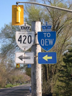
King's Highway 420 is a short urban freeway which provides access to Niagara Falls from the Queen Elizabeth Way (QEW). The highway was once part of the
QEW, but the route was renumbered as Highway 420 in 1972. The highway primarily serves as an
approach road to the Rainbow Bridge, which connects to U.S. Route 62 and New York State Routes 104 & 384 in Niagara Falls, New York. A 1.6 km portion of
Highway 420 from Stanley Avenue to the Rainbow Bridge was transferred from the province to the Regional Municipality of Niagara, effective December 4, 2002. This
transferred section of Highway 420 was subsequently designated as a Municipal Connecting Link by a Minister's Order dated April 30, 2003. This Municipal Connecting
Link is actually signed as Niagara Regional Road 420, and not as Highway 420. Highway 420 is now the shortest 400-Series Highway in Ontario, with a length of only 3.0 km (1.9 miles). Highway 420 is a minimum of four through lanes, depending on the road segment. The highway has an express-collector lane configuration from the QEW to Drummond Road. Unless posted otherwise, the speed limit on Highway 420 is 80 km/h (50 mph). Exits along Highway 420 are not numbered, but distances along the highway can be calculated by visiting the Highway 420 Mileage Chart page. 
 |
|---|
Additional Information About King's Highway 420:
King's Highway 420 - Route Information (At Scott Steeves' website: asphaltplanet.ca)
King's Highway 420 - A Virtual Tour (At Scott Steeves' website: asphaltplanet.ca) |
|---|
Links to Adjacent King's Highway Pages: 

Website contents, photos & text © 2002-2026, Cameron
Bevers (Webmaster) - All Rights Reserved / Contact Me
|
|---|