
| 
|  |
|
|
This page contains historical and present day photos of Ontario's King's Highway 420 (Rainbow Bridge Approach). All
photographs displayed on this page were taken by the Webmaster (Cameron Bevers), unless specifically noted otherwise. Historical photographs are arranged in
approximate chronological order, while present day photographs (Year 2000 to date) are arranged by location from west to east. Click on any thumbnail to see a
larger image!
Please note that all photographs displayed on this
website are protected by copyright. These photographs must not be reproduced, published,
electronically stored or copied, distributed, or posted onto other websites without
my written permission. If you want to use photos from this website, please
email me first for permission. Thank-you!
|
|---|
|
Historical King's Highway 420 Photographs
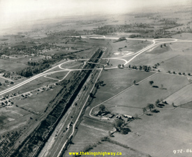

Left - Rainbow Bridge Approach on the Queen Elizabeth Way in Niagara Falls in 1944. This aerial photo shows the Dorchester Road Traffic Circle on the Rainbow
Bridge Approach at the Queenston-Chippawa Power Canal. The Rainbow Bridge Approach (now known as Hwy 420) connects with the Queen Elizabeth Way at the second traffic
circle in the background. The Lundy's Lane Cloverleaf on the Queen Elizabeth Way can be seen at the top of this photo. All three junctions were replaced in the 1970s
with the reconstruction and widening of the Rainbow Bridge Approach. See an Enlarged Photo Here.
Photo taken in 1944. (Photo © Archives of Ontario - Series RG-14-162-5-166, Box B1038, Photo #972-86) Right - Aerial view of the Rainbow Bridge Approach on the Queen Elizabeth Way in 1944, facing east towards Niagara Falls from the Dorchester Road Traffic Circle. See an Enlarged Photo Here. Photo taken in 1944. (Photo © Archives of Ontario - Series RG-14-162-5-166, Box B1038, Photo #972-66) 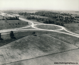
Above - Aerial view of the Rainbow Bridge Approach Traffic Circle on the Queen Elizabeth Way in Niagara Falls in 1944. A new traffic circle was constructed at
the junction of the Queen Elizabeth Way and the new Rainbow Bridge Approach (today's Hwy 420) in Niagara Falls in 1941. Originally, this junction was supposed to be a
grade-separated interchange, but due to the growing shortages of construction materials and labour caused by World War II, it was decided that a traffic circle would
be sufficient to handle the anticipated traffic volumes for the foreseeable future. In fact, the traffic circle remained in service right up until the early 1970s,
when the current multi-level interchange at the Queen Elizabeth Way and Hwy 420 was built in 1971-1972. The Rainbow Bridge lies to the east (left in this photo),
while the top of this photo faces south towards Fort Erie. The Lundy's Lane (Hwy 3A & Hwy 20) Cloverleaf can be seen in the background. See an
Enlarged Photo Here. Photo taken in 1944. (Photo © Archives of Ontario - Series RG-14-162-5-166, Box B1038, Photo #972-61) 

Left - Dorchester Road Traffic Circle on the Queen Elizabeth Way in Niagara Falls. See an
Enlarged Photo Here. Photo taken on April 14, 1961. (Photo courtesy of Ontario Ministry of Transportation - © King's Printer for Ontario, 2013) This early traffic circle was constructed along the Rainbow Bridge Approach (today's Hwy 420) in 1941. The "circle" itself was actually oval-shaped, and connected the dual highway approaching the Rainbow Bridge with Dorchester Road. The Hydro Canal leading to Queenston crossed through the middle of the traffic circle. Please click here to see a 1947 Aerial Photo of the Dorchester Road Traffic Circle. Two new structures were built along the "legs" of the oval to carry the highway perpendicularly across the Hydro Canal. The Dorchester Road Traffic Circle provided a very economical method of joining the two roads together, and worked quite well during the early days of the Queen Elizabeth Way. However, growing traffic volumes in the Niagara Falls area prompted the Department of Highways to replace the old 1941 traffic circle with a modern grade-separated interchange in the early 1970s. The Westbound Queen Elizabeth Way structure seen here was removed in 1971 when a new interchange was built at Dorchester Road and Hwy 420. Right - Hydro Canal Bridge on the Dorchester Road Traffic Circle, facing east towards the Rainbow Bridge in Niagara Falls. Photo taken on April 14, 1961. (Photo courtesy of Ontario Ministry of Transportation - © King's Printer for Ontario, 2013) 

Left - Approaching the exit to Dorchester Road North on the Queen Elizabeth Way in Niagara Falls. Note the oversized checkerboard sign at the far side of the
structure, to warn drivers of the sharp curve ahead. The elongated oval shape of the Dorchester Road Traffic Circle and tangential entries and exits on the Queen
Elizabeth Way encouraged motorists to travel through this rotary intersection at much higher speeds than what would be possible in a modern roundabout design.
Excessive circle diameter and tangential entries and exits were common geometric design problems which plagued many older rotary intersections in North America. This
led to a general rejection of the overall concept of rotary intersections by North American road authorities for almost 40 years, until more compact modern
roundabouts with curved entries and exits began to appear in the 1990s. The first modern roundabout built on an Ontario provincial highway was completed on Hwy 33 in
Picton in 2009. See an Enlarged Photo Here. Photo taken on April 14, 1961. (Photo courtesy of Ontario Ministry of Transportation - © King's Printer for Ontario, 2013) Right - Hydro Canal Bridge on the Queen Elizabeth Way at the Dorchester Road Traffic Circle in Niagara Falls (April 14, 1961) (Photo courtesy of Ontario Ministry of Transportation - © King's Printer for Ontario, 2013) 
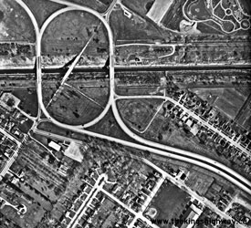
Left - Circa 1965 aerial view of the Rainbow Bridge Approach and Queen Elizabeth Way Junction
in Niagara Falls. During construction of the Rainbow Bridge Approach (today's Hwy 420) in 1941, a decision was made to construct a traffic circle at the Queen
Elizabeth Way and Rainbow Bridge Approach Junction instead of a grade-separated interchange. This traffic circle remained in service right up until the early 1970s,
when the current multi-level interchange was built in 1971-1972. The Rainbow Bridge lies to the east (right in this photo), while the top of this photo faces north
towards St. Catharines and Toronto. See an Enlarged Photo Here. (Photo courtesy of Ontario Ministry of Transportation - © King's Printer for Ontario, 2014) Right - Circa 1965 aerial view of the Dorchester Traffic Circle on the Rainbow Bridge Approach section of the Queen Elizabeth Way (today's Hwy 420) in Niagara Falls. Completed in 1941, this traffic circle spanned the Hydro Canal and connected the north and south legs of Dorchester Road together. The Dorchester Traffic Circle remained in service right up until the early 1970s, when a new partial cloverleaf interchange was built at Dorchester Road and the reconstructed Rainbow Bridge Approach section of the Queen Elizabeth Way. The original Dorchester Road structure over the Hydro Canal can be seen in the centre of the oval-shaped traffic circle. The old bridge was closed to traffic in 1941 and fell into disuse for almost three decades. The old structure was finally removed in 1970 during preparatory work for the construction of the adjacent multi-level interchange on the Queen Elizabeth Way. The Rainbow Bridge lies to the east (lower-right corner in this photo), while the junction with the mainline Queen Elizabeth Way between Fort Erie and St. Catharines lies to the west (upper-left corner in this photo). See an Enlarged Photo Here. (Photo courtesy of Ontario Ministry of Transportation - © King's Printer for Ontario, 2014) 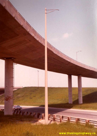
Above - Southern side of the westbound Hwy 420 Flyover to the Fort Erie-bound Queen Elizabeth Way (Bridge #4) in Niagara Falls. See an
Enlarged Photo Here. Photo taken in June 2, 1981. (Photo courtesy of Ontario Ministry of Transportation - © King's Printer for Ontario, 2022) 

Left - Deck view of the westbound Hwy 420 Flyover to the Fort Erie-bound Queen Elizabeth Way (Bridge #4) in Niagara Falls. This complicated freeway ramp
structure features an alignment with a reverse curve. This reverse curve is rather evident in this photo. See an
Enlarged Photo Here. Photo taken in June 2, 1981. (Photo courtesy of Ontario Ministry of Transportation - © King's Printer for Ontario, 2022) Right - Overhead guide sign for the Hwy 420 and Hwy 20 Interchange on the Queen Elizabeth Way in Niagara Falls. Photo taken on September 16, 1981. (Photo courtesy of Ontario Ministry of Transportation - © King's Printer for Ontario, 2011) 
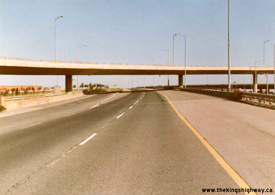
Left - Facing towards Toronto across the Hwy 420 Flyover (Bridge #2) across the Queen Elizabeth Way in Niagara Falls. See an
Enlarged Photo Here. Photo taken on September 24, 1981. (Photo courtesy of Ontario Ministry of Transportation - © King's Printer for Ontario, 2022) Right - Fort Erie-bound lanes of the Queen Elizabeth Way at the Hwy 420 Underpass (Bridge #3) in Niagara Falls, facing towards Toronto. The westbound Hwy 420 Flyover to the Fort Erie-bound Queen Elizabeth Way (Bridge #4) can be seen crossing over the highway. See an Enlarged Photo Here. Photo taken on September 24, 1981. (Photo courtesy of Ontario Ministry of Transportation - © King's Printer for Ontario, 2022) 

Left - Eastern side of the Fort Erie-bound Queen Elizabeth Way structure over Hwy 420 (Bridge #3) in Niagara Falls. This four-level interchange replaced a
traffic circle on the Queen Elizabeth Way in the early 1970s. See an Enlarged Photo Here. Photo
taken on September 24, 1981. (Photo courtesy of Ontario Ministry of Transportation - © King's Printer for Ontario, 2022) Right - Facing towards Toronto at the flyover between the Queen Elizabeth Way and Hwy 420 across the westbound lanes of Hwy 420 (Bridge #7) in Niagara Falls. See an Enlarged Photo Here. Photo taken on September 24, 1981. (Photo courtesy of Ontario Ministry of Transportation - © King's Printer for Ontario, 2022) 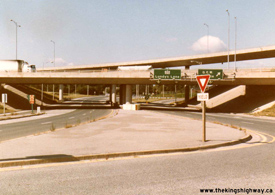
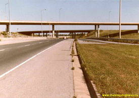
Left - Eastern side of the Toronto-bound Queen Elizabeth Way structure over Hwy 420 (Bridge #6) in Niagara Falls. An overhead bridge-mounted guide sign
directed westbound Hwy 420 traffic to "Hwy 20 Lundy's Lane". See an Enlarged Photo Here. Photo
taken on September 24, 1981. (Photo courtesy of Ontario Ministry of Transportation - © King's Printer for Ontario, 2022) Right - Toronto-bound lanes of the Queen Elizabeth Way at the Hwy 420 Underpass (Bridge #6) in Niagara Falls, facing towards Toronto. See an Enlarged Photo Here. Photo taken on September 24, 1981. (Photo courtesy of Ontario Ministry of Transportation - © King's Printer for Ontario, 2022) 
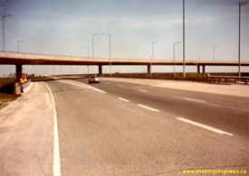
Left - Flyover from the Toronto-bound Queen Elizabeth Way to eastbound Hwy 420 (Bridge #8) in Niagara Falls. See an
Enlarged Photo Here. Photo taken on September 24, 1981. (Photo courtesy of Ontario Ministry of Transportation - © King's Printer for Ontario, 2022) Right - Southern side of the flyover from westbound Hwy 420 to the Fort Erie-bound Queen Elizabeth Way (Bridge #4) in Niagara Falls, crossing the Fort Erie-bound lanes of the Queen Elizabeth Way. The Hwy 420 Underpass (Bridge #3) can be seen in the foreground. See an Enlarged Photo Here. Photo taken on May 18, 1983. (Photo courtesy of Ontario Ministry of Transportation - © King's Printer for Ontario, 2022) 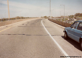
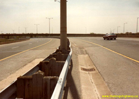
Left - Flyover between the Toronto-bound Queen Elizabeth Way and eastbound Hwy 420 across the eastbound lanes of Hwy 420 (Bridge #8), facing towards Downtown
Niagara Falls. See an Enlarged Photo Here. Photo taken on May 18, 1983. (Photo courtesy of Ontario Ministry of Transportation - © King's Printer for Ontario, 2022) Right - Facing towards Downtown Niagara Falls across the Hwy 420 Flyover (Bridge #2) across the Queen Elizabeth Way. See an Enlarged Photo Here. Photo taken on May 18, 1983. (Photo courtesy of Ontario Ministry of Transportation - © King's Printer for Ontario, 2022) 
Above - Flyover between the Queen Elizabeth Way and Hwy 420 across the westbound lanes of Hwy 420 (Bridge #7), facing towards Downtown Niagara Falls. See an
Enlarged Photo Here. Photo taken on May 18, 1983. (Photo courtesy of Ontario Ministry of Transportation - © King's Printer for Ontario, 2022) |
|---|
Links to Adjacent King's Highway Photograph Pages:
Back to King's Highway 417 Photos /
King's Highway 420 History /
On to King's Highway 427 Photos
Ontario Highway History - Main Menu / Back to List of Highways Website contents, photos & text © 2002-2026, Cameron
Bevers (Webmaster) - All Rights Reserved / Contact Me
|
|---|