| 
| |
|
|
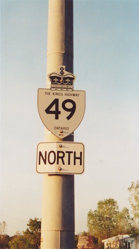
History of King's Highway 49 (#2): King's Highway 49 is a minor collector highway which once connected Picton and Prince Edward County with Highway 401
east of Belleville. Only one short section of this highway now remains near Deseronto, because the highway was almost completely downloaded in 1998. Despite
the downloading, Highway 49 still forms an important highway link between Prince Edward County and the mainland. Only two other bridges link to Prince
Edward County. The other two bridges are located on Highway 62 near Belleville and Highway 33 south of Trenton. Highway 49 was first established in 1965, when a new highway link was established between Prince Edward County and the mainland. The discontinuous southern section of Highway 41 from Picton to Coles Wharf was renumbered as Highway 49. With the completion of the Quinte Skyway on September 6, 1967, a direct connection between Picton and Highway 401 was put into service. The route of Highway 49 did not change until 1998, when most sections of the highway were lost to downloading. The Ontario Government retained ownership of the Quinte Skyway and the section of Highway 49 lying within the Tyendinaga Mohawk Territory near Deseronto. The rest of the highway was downloaded, and is now known as Prince Edward Road 49 and Hastings Road 15. Highway 49 is now only 6.1 km long, and no longer connects to any other provincial highways. Highway 49 traverses a predominantly rural portion of Eastern Ontario. The only major towns located along the original highway are Picton and Deseronto. Services are available in most communities along the highway. Most sections of Highway 49 are two lanes, but passing lanes appear occasionally along the highway. There are no tolls for vehicles using the Quinte Skyway. The speed limit on Highway 49 is 80 km/h (50 mph), unless posted otherwise. Please visit the Highway 49 Mileage Chart page for a list of mileage reference points along Highway 49. 
 |
|---|