Hwy 549 Sign Graphic Hwy 549 Title Graphic Hwy 549 Sign Graphic   

Ontario Highway 549 Quick Facts:
  • Years in Existence: 1956-1984
  • Current Status: Decommissioned
  • Current Name: Sudbury Road 10
  • Location: Northeastern Ontario
  • District Served: Sudbury
  • Towns Served: None
  • Southern Terminus: Lake Panache
  • Northern Terminus: Hwy 17 - Sudbury
  • Length in 1984: 14.3 km / 8.9 miles
HWY 549 ROUTE MARKER - © Josh Anderchek
Secondary Highway 549 Sign © Josh Anderchek

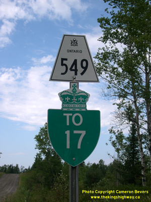
History of Secondary Highway 549:

Secondary Highway 549 was a local highway that once connected Lake Panache to Highway 17 near Whitefish, located southwest of Sudbury. The Lake Panache Road was first shown on a Preliminary Route Plan dated May 1956. The entire route was designated by an Order-in-Council dated May 9, 1956. Highway 549 was paved from the Highway 17 Junction to the Vermilion River Bridge in 1972, and the rest of the highway was paved in 1980. The entire route of Highway 549 was transferred from the province to the Regional Municipality of Sudbury, effective December 20, 1984. The road is known today as Sudbury Road 10.


Back to Hwy 548   /    On to Hwy 550

Ontario Highway History - Main Menu   /    Back to List of Highways


Website contents, photos & text © 2002-2023, Cameron Bevers (Webmaster) - All Rights Reserved  /  Contact Me


Valid HTML 4.01!   Valid CSS!