| 
| |
|
|
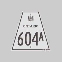
History of Secondary Highway 604A:
Secondary Highway 604A was a local highway that once connected Highway 604 northeast of Kenora to Kenora Airport. The road which ultimately became Secondary Highway
604A was first designated by an Order-in-Council dated May 9, 1956. However, it is believed that this short spur was originally signed as Highway 604, not
Highway 604A. The highway was given its own suffixed route number at some point after 1956, but the exact year is not known. The route number of
Highway 604A never appeared on the Official Ontario Road Map, but did appear in mileage tables produced by the Department of Highways of Ontario (DHO). The highway
was gravel-surfaced at first, but a primed bituminous surface was constructed along the highway in 1964. The route of Highway 604A was renumbered as
Highway 604, effective September 1, 1964. That highway was subsequently transferred to the Town of
Jaffray-Melick in 1997. The former highway is now under the jurisdiction of the City of Kenora and is known today as Airport Road.
|
|---|
Links to Adjacent Secondary Highway Pages: Website contents, photos & text © 2002-2025, Cameron
Bevers (Webmaster) - All Rights Reserved / Contact Me |
|---|