Hwy 7A (Alt) Hwy 7A (Alt) Port Perry Hwy 7A (Alt)   

Ontario Highway 7A (Alt) Quick Facts:
  • Years in Existence: 1944-1963
  • Current Status: Decommissioned in 1963
  • Current Names: Queen Street & Water Street
  • Location: Central Ontario
  • Counties Served: Durham
  • Towns Served: Port Perry
  • Western Terminus: Hwy 7A - West of Port Perry
  • Eastern Terminus: Hwy 7A - Port Perry
  • Length in 1963: 2.1 km / 1.3 miles
HWY 7A
King's Highway 7A Sign
Image courtesy of Jamie Malecki

History of King's Highway 7A (Alt) Port Perry:

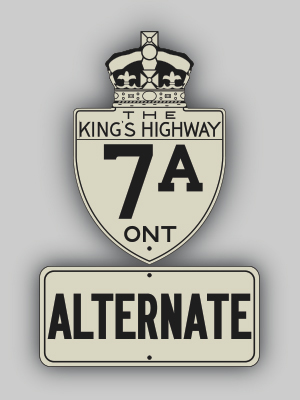
King's Highway 7A (Alt) was created in 1944, when a 2.1 km alternate route to Highway 7A was established through Downtown Port Perry. Under a connecting link agreement with the Department of Highways (DHO), a Highway 7A (Alt) route was signed along Queen Street and Water Street through Port Perry. The connecting link agreement was dated June 5, 1944. It is not certain how long Port Perry's Highway 7A (Alt) route lasted. The most recent reference to the highway in a DHO document was dated January, 1963. The route does not appear in the 1963 DHO mileage table, suggesting that the route was decommissioned at some point during 1963.


HWY 7A ALT PORT PERRY ROUTE MAP - © Cameron Bevers             HWY 7A ALT PORT PERRY PHOTOGRAPHS - © Cameron Bevers


Additional Information About King's Highway 7A (Alt):

Learn More About King's Highway 7A (Alt)  (My Upcoming Publications)


BACK TO HWY 7A - © Cameron Bevers             BACK TO MAIN MENU - © Cameron Bevers             ON TO HWY 7A ALT KITCHENER - © Cameron Bevers


Website contents, photos & text © 2002-2012, Cameron Bevers (Webmaster) - All Rights Reserved  /  Contact Me


Valid HTML 4.01!   Valid CSS!