| 
| |
|
|
History of King's Highway 7A:
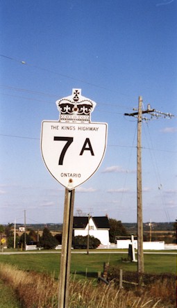
King's Highway 7A is an arterial highway in the Regional Municipality of Durham, the County of Peterborough and the City of Kawartha Lakes (formerly the County of
Victoria) which serves as an alternate route to Highway 7 between Manchester and Cavan. Highway 7A allows through traffic to bypass the longer, more circuitous route
of Highway 7 via Sunderland and Lindsay. The history of Highway 7A dates back to the late 1930s, when the Department of Highways of Ontario (DHO) assumed a new King's
Highway through the former Counties of Ontario and Durham. Preliminary Route Plans were prepared by the DHO in October 1937, which showed the proposed route of a new
King's Highway along the existing county road via Port Perry, Bethany and Cavan. The new highway began at the Highway 7 & Highway 12 Junction at Manchester west
of Port Perry and ended at the Highway 7 Junction in the City of Peterborough. The 34-mile section of Highway 7A lying between Manchester and the Highway 28 Junction
near Fraserville southwest of Peterborough was first assumed by the DHO on April 13, 1938. About 1 mile of Highway 7A ran concurrently with
Highway 35. In order to connect the route of Highway 7A back to Highway 7 in Peterborough, the Highway 7A
designation was extended north concurrently with Highway 28 to Peterborough, via Springville and Five Mile
Corners. In addition, Highway 7A absorbed the route of Highway 7C through the City of Peterborough. The 4 km
route of Highway 7C had been assumed by the DHO as a new King's Highway back in 1933, in order to allow through traffic to bypass Downtown Peterborough. The former
route of Highway 7C provided a direct connection via Lansdowne Street between Highway 7 and the Highway 7A & Highway 28 Junction at the western entrance to the
City of Peterborough. The new route of Highway 7A between Manchester and Peterborough was 68 km (42 miles) in length
(See Map). As originally assumed in 1938, the only paved section along Highway 7A was at the western end of the highway between Manchester and Port Perry and the eastern section of the highway from the Highway 28 Junction to Peterborough. These sections of Highway 7A had been paved prior to the establishment of Highway 7A in 1938. However, from Port Perry easterly to the Highway 28 Junction, Highway 7A was initially an unimproved road with an earth surface. The DHO quickly surfaced the highway between Port Perry and the Highway 28 Junction with gravel in order to create an all-weather route. The 6-mile section of Highway 7A from Port Perry easterly to Caesarea was paved in 1939. Initially, the entire route of Highway 7A was under the jurisdiction of the DHO. However, as the City of Peterborough's urban limits expanded, portions of Highway 7A were transferred to the municipality. The section of Highway 7A via Lansdowne Street between the Highway 7 Junction at George Street and the western city limits near today's intersection of Wightman Avenue was transferred from the DHO to the City of Peterborough, effective May 21, 1945. Although it was subsequently renumbered as Highway 7 in 1960, jurisdiction over the remaining provincially-owned section of Lansdowne Street between Wightman Avenue and Highway 28 (Clonsilla Avenue) was transferred to the City of Peterborough, effective April 25, 1964. In October 1954, a new arterial highway known as Highway 115 opened to traffic between Peterborough and Newcastle. This new highway ran northeasterly from Enterprise Hill on Highway 35 to Highway 28 at Springville, crossing Highway 7A just east of Cavan. As a result, Highway 115 bypassed a short section of Highway 7A between Cavan and Fraserville. In order to simplify highway numbering, Highway 7A was rerouted so that it ran concurrently with Highway 115 between Cavan and Highway 28. The old section of Highway 7A between the Highway 115 Junction and Fraserville was decommissioned as a King's Highway. The bypassed highway was transferred from the province to the Township of Cavan on November 15, 1954. This former section of Highway 7A is known today as Moore Drive. In 1960, Highway 7 was rerouted through Peterborough. The new route of Highway 7 absorbed the section of Highway 7A along Lansdowne Street immediately west of Peterborough. As a result, the DHO decided to truncate Highway 7A at its junction with Highway 115 near Cavan (See Map). The former overlapped route of Highway 7A & Highway 28 between Springville and Five Mile Corners was thus discontinued in 1960. After the route was shortened in 1960, the length of Highway 7A stood at 51 km (32 miles). In 1957, paving was completed along the section of Highway 7A which overlapped with Highway 35 south of Lindsay. Highway 7A was paved from the Highway 35 Junction to Bethany in 1960. Paving was finally completed between Caesarea and the Highway 35 Junction in 1963. The final gravel-surfaced section on Highway 7A from Bethany to the Highway 115 Junction near Cavan was paved in 1968. In 1984, a route renumbering took place in the Peterborough area. Highway 28 was rerouted onto a newly-opened section of Highway 115 between Springville and Peterborough. However, this created a route numbering headache for the Ministry of Transportation of Ontario which took until 2003 to completely resolve. When the Highway 28 designation was removed from the highway through Springville, it left this short but important section of highway without a route number. The MTO decided to number this former section of Highway 28 as Highway 7A (See Map). However, in order to do this, Highway 7A had to be posted concurrently with Highway 115 for 4.5 km between Cavan and Springville. The length of Highway 7A was increased to 56.9 km as a result of the highway renumbering in 1984. The extension of Highway 7A to Springville in 1984 finally reunited Highway 7A with Highway 7 at the route's eastern terminus after a 24-year hiatus. However, it created a very confusing series of overlapped route designations along Highway 115. The mass highway downloading of 1997-1998 sparked yet another round of route renumbering which took place on May 1, 2003. That day, Highway 7A was truncated at the Highway 115 Junction near Cavan, essentially reversing the 1984 route renumbering. The former section of Highway 7A through Springville was absorbed into the route of Highway 7, and the concurrent routing of Highway 7A & Highway 115 between Cavan and Springville was discontinued. Since 2003, Highway 7A has been 48.7 km in length. Highway 7A is now one of only two signed alternate King's Highway routes left in the province. The only other King's Highway with an "A" suffixed route which serves as an alternate route is the Kenora Bypass (Highway 17A). Welland's Highway 58A is still signed today, but this highway is technically not an alternate route to its parent highway (Highway 58). Highway 7A is primarily a rural two-lane highway, with a short multi-lane section through Port Perry. Services are available in most major communities along Highway 7A. The speed limit on Highway 7A is 80 km/h (50 mph), unless posted otherwise. Highway 7A is signed concurrently with Highway 35 for a distance of 1.5 km west of Bethany. Please visit the Highway 7A Mileage Chart page for a list of mileage reference points along Highway 7A. 
 |
|---|
Additional Information About King's Highway 7A:
King's Highway 7A - Route Information (At Scott Steeves' website: asphaltplanet.ca)
King's Highway 7A - A Virtual Tour (At Scott Steeves' website: asphaltplanet.ca) |
|---|
Links to Adjacent King's Highway Pages: 


Website contents, photos & text © 2002-2025, Cameron
Bevers (Webmaster) - All Rights Reserved / Contact Me |
|---|