
| 
| |
|
|
This page contains historical photos of Ontario's King's Highway 101 dating from 1939 to 1999, along with historical photos of
Ontario's King's Highway 67 from Pamour to Timmins which later became King's Highway 101. All photographs displayed on this page were taken by the Ontario Ministry of
Transportation, unless specifically noted otherwise. Historical photographs are arranged in approximate chronological order. Click on any thumbnail to see a larger
image!
Please note that all photographs displayed on this
website are protected by copyright. These photographs must not be reproduced, published,
electronically stored or copied, distributed, or posted onto other websites without
my written permission. If you want to use photos from this website, please
email me first for permission. Thank-you!
|
|---|
|
Page 1: Historical King's Highway 101 Photographs


Left - New concrete pavement on Hwy 67 (later known as Hwy 101) near the Hollinger Gold Mine in Timmins. Photo taken on October 14, 1939. (Photo courtesy of Ontario Ministry of Transportation - © King's Printer for Ontario, 1939) Right - New concrete pavement on Hwy 67 (later known as Hwy 101) near Porcupine. Photo taken on October 14, 1939. (Photo courtesy of Ontario Ministry of Transportation - © King's Printer for Ontario, 1939) 
Above - View of Hwy 67 (later known as Hwy 101) about 1 mile east of Schumacher in 1939, facing east towards Porcupine. During 1938, concrete pavement was
constructed along Hwy 67 for a distance of about 7 miles between Timmins and Porcupine. To my knowledge, this was the only King's Highway ever built in this region of
Ontario with a concrete surface. See an Enlarged Photo Here. Photo taken on October 14, 1939. (Photo courtesy of Ontario Ministry of Transportation - © King's Printer for Ontario, 1939) 
Above - Facing west along Hwy 67 (later known as Hwy 101) towards Timmins, about 1 mile west of South Porcupine. See an
Enlarged Photo Here. Photo taken in September 1946. (Photo courtesy of Ontario Ministry of Transportation - © King's Printer for Ontario, 1946) 

Left - Constructing granular base on Hwy 101 west of Matheson (1950) (Photo courtesy of Ontario Ministry of Transportation - © King's Printer for Ontario, 1950) Right - Paving operations on Hwy 101 west of Matheson (1950) (Photo courtesy of Ontario Ministry of Transportation - © King's Printer for Ontario, 1950) 
Above - Facing east along Hwy 101 between Schumacher and Porcupine, showing a new westbound passing lane. Photo taken on September 12, 1957. (Photo courtesy of Ontario Ministry of Transportation - © King's Printer for Ontario, 1957) 
Above - The construction of the Foleyet-Chapleau Resources Road (Hwy 101) was a joint project between the New Liskeard and the Sault Ste. Marie Department of
Highways of Ontario (DHO) District Offices. The New Liskeard DHO District supervised the construction of the highway from the Foleyet end, while the Sault Ste. Marie
DHO District supervised construction from the Chapleau end. The New Liskeard DHO District Team, from left to right, are: Adelard Thibault; Henry Radziminski; Don
Ferguson, Chief Clerk and L.A. Peever, Project Supervisor. Photo taken Summer, 1959. (Photo courtesy of Ontario Ministry of Transportation - © King's Printer for Ontario, 1959) 

Left - Construction of the Foleyet-Chapleau Resources Road (Hwy 101), west of Foleyet (August, 1959) (Photo courtesy of Ontario Ministry of Transportation - © King's Printer for Ontario, 1959) Right - Construction of the Foleyet-Chapleau Resources Road (Hwy 101), west of Foleyet (August 12, 1959) (Photo courtesy of Ontario Ministry of Transportation - © King's Printer for Ontario, 1959) 
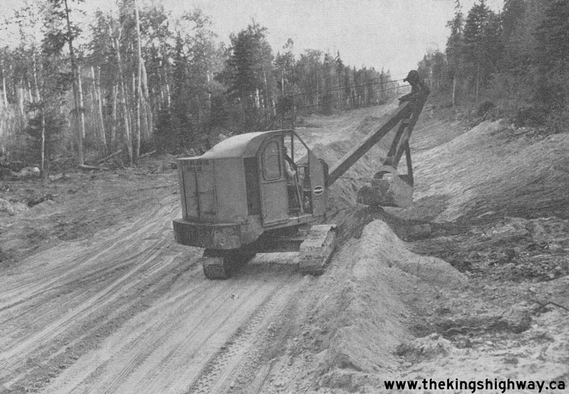
Left - Grading in progress on the Foleyet-Chapleau Resources Road (Hwy 101), 4 miles west of Foleyet (August 12, 1959) (Photo courtesy of Ontario Ministry of Transportation - © King's Printer for Ontario, 1959) Right - Construction at the end of the Foleyet section of the Foleyet-Chapleau Resources Road (Hwy 101). This photo was taken 8 miles west of Foleyet on August 12, 1959. (Photo courtesy of Ontario Ministry of Transportation - © King's Printer for Ontario, 1959) 
Above - Completed section of the Foleyet-Chapleau Resources Road (Hwy 101), 3 miles west of Foleyet in 1959. Progress on the Foleyet-Chapleau Resources Road
was so rapid, that the road essentially appeared within a matter of weeks during the Summer of 1959. Although it may seem hard to believe, the contract to build
this section of the Foleyet-Chapleau Resources Road was only started about 6 weeks before this photo was taken. On July 1st, there was no road here. Photo taken on
August 12, 1959. (Photo courtesy of Ontario Ministry of Transportation - © King's Printer for Ontario, 1959) 
Above - Staff from the Foleyet-Chapleau Resources Road (Hwy 101) Engineering and Construction Team, Chapleau Section - They are from left to right: Leon
Marcil, Clearing Foreman; Adelard Fournier, Inspector; Lloyd Burley, Project Supervisor; Calvin McLure, Construction Supervisor; and Jean Tremblay, Sub-Foreman. This
photo was taken about 20 miles east of Chapleau, during clearing operations. Photo taken in January, 1960. (Photo courtesy of Ontario Ministry of Transportation - © King's Printer for Ontario, 1960) 
Above - Construction crew on the Foleyet-Chapleau Resources Road (Hwy 101), warming up by a campfire during the frigid winter of 1959-1960. Survey and
construction crews worked in temperatures as low as -32 F (-35 C) throughout the winter. Despite the bitter cold, challenges inherent to road construction in remote
locations and other unforeseen construction problems, Hwy 101 was completed and opened to traffic between Timmins and Chapleau about 2 1/2 years later, in June, 1962.
Photo taken in January, 1960. (Photo courtesy of Ontario Ministry of Transportation - © King's Printer for Ontario, 1960) 
Above - End of an era: The construction of the Foleyet-Chapleau Resources Road (Hwy 101) from the Chapleau end during the Winter of 1959-1960 is believed to
have been the last time horses were used to transport equipment and materials to an Ontario provincial highway construction site. Early mechanical construction
equipment often encountered difficulties in extremely rough terrain, giving old-fashioned "horsepower" a distinct advantage. By the 1960s, however, construction
equipment had been developed that could forge ahead through virtually any terrain. Photo taken in January, 1960. (Photo courtesy of Ontario Ministry of Transportation - © King's Printer for Ontario, 1960) 
Above - Sault Ste. Marie DHO District Staff on the Foleyet-Chapleau Resources Road (Hwy 101). They are from left to right: Calvin McLure, Construction
Supervisor; Lloyd Burley, Project Supervisor; Dan Collins, Sault Ste. Marie District Engineer; and Bob Young, Manager, DHO Resources and Access Roads. Photo taken in
March, 1961. (Photo courtesy of Ontario Ministry of Transportation - © King's Printer for Ontario, 1961) 

Left - Sault Ste. Marie DHO District Staff checking plans for the Foleyet-Chapleau Resources Road (Hwy 101). They are from left to right: Matt Bernhardt,
Construction Engineer; Calvin McLure, Construction Supervisor; Lloyd Burley, Project Supervisor; and Dan Collins, Sault Ste. Marie District Engineer. The buses in the
background of this photo were used to transport construction crews from Chapleau to the highway construction site. This was a departure from earlier DHO
practice, where remote road camps were established at various points along the highway while it was being constructed. Photo taken in March, 1961. (Photo courtesy of Ontario Ministry of Transportation - © King's Printer for Ontario, 1961) Right - Construction of Hwy 101 between Chapleau and Foleyet (1961) (Photo courtesy of Ontario Ministry of Transportation - © King's Printer for Ontario, 1961) 

Left - Grading on a new alignment of Hwy 101 west of the Hwy 576 Junction near Timmins (1971) (Photo courtesy of Ontario Ministry of Transportation - © King's Printer for Ontario, 1971) Right - Heavy grading on a revised alignment of Hwy 101 west of Foleyet (1971) (Photo courtesy of Ontario Ministry of Transportation - © King's Printer for Ontario, 1971) 
Above - Newly-installed overhead directional guide signs at the Hwy 11 & Hwy 101 Junction west of Matheson. See an
Enlarged Photo Here. Photo taken in 1974. (Photo courtesy of Ontario Ministry of Transportation - © King's Printer for Ontario, 1974) 

Left - Construction of the Mattawasaga River Bridge on Hwy 101 near the Ontario-Quebec Boundary (1977) (Photo courtesy of Ontario Ministry of Transportation - © King's Printer for Ontario, 1977) Right - New Ontario Northland Railway Subway on Algonquin Boulevard (Hwy 101) in Timmins (1977) (Photo courtesy of Ontario Ministry of Transportation - © King's Printer for Ontario, 1977) 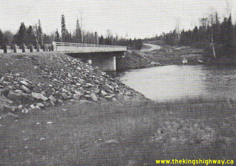

Left - New Groundhog River Bridge on Hwy 101 between Foleyet and Timmins (1978) (Photo courtesy of Ontario Ministry of Transportation - © King's Printer for Ontario, 1978) Right - Resurfaced section of Hwy 101 near the Hwy 651 Junction east of Wawa (1978) (Photo courtesy of Ontario Ministry of Transportation - © King's Printer for Ontario, 1978)
Continue on to King's Highway 101 Present Day Photos: Wawa to Chapleau
|
|---|
Links to Adjacent King's Highway Photograph Pages:
Back to King's Highway 100 (#2) Photos /
King's Highway 101 History /
On to King's Highway 102 (#1) Photos
Ontario Highway History - Main Menu / Back to List of Highways Website contents, photos & text © 2002-2026, Cameron
Bevers (Webmaster) - All Rights Reserved / Contact Me
|
|---|