
| 
| |
|
|
This page contains present day photos (Year 2000 to date) of Ontario's King's Highway 101, arranged by location from Wawa
easterly to Chapleau. All photographs displayed on this page were taken by the Webmaster (Cameron Bevers), unless specifically noted otherwise. Click on any
thumbnail to see a larger image!
Please note that all photographs displayed on this
website are protected by copyright. These photographs must not be reproduced, published,
electronically stored or copied, distributed, or posted onto other websites without
my written permission. If you want to use photos from this website, please
email me first for permission. Thank-you!
|
|---|
|
Page 2: Present Day King's Highway 101 Photographs (Wawa to Chapleau)


Left - Junction signs at the Hwy 101 and Hwy 17 junction in Wawa. See an
Enlarged Photo Here. (Photograph taken on July 2, 2006 - © Cameron Bevers) Right - Green directional sign for Hwy 101 on Hwy 17 in Wawa. See an Enlarged Photo Here. (Photograph taken on July 2, 2006 - © Cameron Bevers) 

Left - Junction of Hwy 101 and Hwy 17 in Wawa. See an
Enlarged Photo Here. (Photograph taken on July 2, 2006 - © Cameron Bevers) Right - Approaching the Hwy 17 junction along Hwy 101 west of Wawa. See an Enlarged Photo Here. (Photograph taken on July 2, 2006 - © Cameron Bevers) 

Left - Facing south along Hwy 17 towards the Hwy 101 junction in Wawa. See an
Enlarged Photo Here. (Photograph taken on July 2, 2006 - © Cameron Bevers) Right - Facing north along Hwy 17 towards the Hwy 101 junction in Wawa. See an Enlarged Photo Here. (Photograph taken on July 2, 2006 - © Cameron Bevers) 

Left - A directional ramp branches off of Hwy 17 North onto Hwy 101 East at Wawa. See an
Enlarged Photo Here. (Photograph taken on July 2, 2006 - © Cameron Bevers) Right - Close-up view of directional ramp to Hwy 101 East at Wawa. See an Enlarged Photo Here. (Photograph taken on July 2, 2006 - © Cameron Bevers) 

Left - Hwy 101 turns right onto a different roadway in Wawa. The through road at this intersection becomes Broadway Avenue leading into Downtown Wawa. To
continue east towards Chapleau, eastbound Hwy 101 traffic must turn right onto Main Street. Westbound Hwy 101 traffic must turn left at the end of Main Street to
access Hwy 17. See an Enlarged Photo Here. (Photograph taken on July 16, 2007 - © Cameron Bevers) Right - An inconspicuous pair of green fingerboard signs mark the Hwy 101 turn-off onto Main Street. See an Enlarged Photo Here. (Photograph taken on July 16, 2007 - © Cameron Bevers) 

Left - Green guide sign marking the turn-off to Hwy 101 East in Wawa. See an
Enlarged Photo Here. (Photograph taken on July 16, 2007 - © Cameron Bevers) Right - Divided section of Hwy 101 (Main Street) in Wawa. See an Enlarged Photo Here. (Photograph taken on July 16, 2007 - © Cameron Bevers) 

Left - Facing west along Hwy 101 at the entrance to Wawa. Here, Hwy 101 widens into a divided highway. See an
Enlarged Photo Here. (Photograph taken on July 16, 2007 - © Cameron Bevers) Right - Directional guide sign approaching the Hwy 547 Junction on eastbound Hwy 101 east of Wawa. See an Enlarged Photo Here. (Photograph taken on July 16, 2007 - © Cameron Bevers) 

Left - Facing west along Hwy 101 towards Wawa from the Hwy 547 Junction. These two highways intersect about 19 km east of Wawa. See an
Enlarged Photo Here. (Photograph taken on July 16, 2007 - © Cameron Bevers) Right - Approaching the Hwy 547 Junction on eastbound Hwy 101 from Wawa. Since most traffic on southbound Hwy 547 turns right towards Wawa on westbound Hwy 101, a channelized right-turn lane was built at this junction. This section of Hwy 101 was reconstructed in 2006-2007. See an Enlarged Photo Here. (Photograph taken on July 16, 2007 - © Cameron Bevers) 

Left - Facing east along Hwy 101 towards Chapleau from the Hwy 547 Junction. See an
Enlarged Photo Here. (Photograph taken on July 16, 2007 - © Cameron Bevers) Right - Facing north along Hwy 547 towards Hawk Junction from the Hwy 101 Junction. See an Enlarged Photo Here. (Photograph taken on July 16, 2007 - © Cameron Bevers) 

Left - Facing north along Hwy 547 from the Hwy 101 Junction. The small community of Hawk Junction lies 6 km away at the north end of Hwy 547. See an
Enlarged Photo Here. (Photograph taken on July 16, 2007 - © Cameron Bevers) Right - Southern terminus of Hwy 547 at Hwy 101, located about 19 km east of Wawa. See an Enlarged Photo Here. (Photograph taken on July 16, 2007 - © Cameron Bevers) 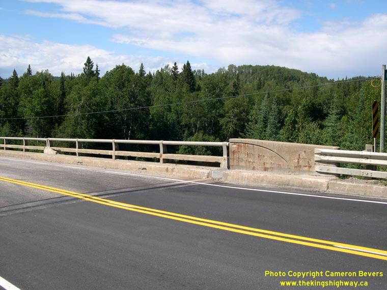

Left - The handrail design on the Michipicoten River Bridge is unique. The handrail consists of a concrete beam hub rail and a steel tube handrail. To my
knowledge, this is the only surviving example of this rather peculiar railing design on an Ontario provincial highway bridge. See an
Enlarged Photo Here. (Photograph taken on July 16, 2007 - © Cameron Bevers) Right - Facing west along Hwy 101 towards Wawa at the Michipicoten River Bridge. See an Enlarged Photo Here. (Photograph taken on July 16, 2007 - © Cameron Bevers) 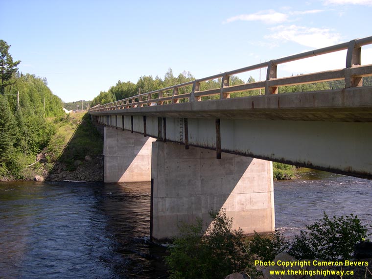

Left - Northern side of the Michipicoten River Bridge on Hwy 101 near Hawk Junction, located about 30 km east of Wawa. See an
Enlarged Photo Here. (Photograph taken on July 16, 2007 - © Cameron Bevers) Right - Structure identification number and date stamp (1965) on the Michipicoten River Bridge. See an Enlarged Photo Here. (Photograph taken on July 16, 2007 - © Cameron Bevers) 

Left - Facing east along Hwy 101 towards Chapleau at the Michipicoten River Bridge east of Hawk Junction. See an
Enlarged Photo Here. (Photograph taken on July 16, 2007 - © Cameron Bevers) Right - Southern side of the Michipicoten River Bridge on Hwy 101. This three-span continuous steel beam structure was completed in 1965. See an Enlarged Photo Here. (Photograph taken on July 16, 2007 - © Cameron Bevers) 

Left - Facing east along Hwy 101 through a large rock cut about 1 km east of the Michipicoten River Bridge. The highway passes through the most rugged terrain
along its entire route between Wawa and the Hwy 651 Junction. The terrain along the rest of Hwy 101 from that point to Timmins is much more subdued. See an
Enlarged Photo Here. (Photograph taken on July 16, 2007 - © Cameron Bevers) Right - Resurfaced section of Hwy 101 near Lac de Zajac, located about 32 km east of Wawa. See an Enlarged Photo Here. (Photograph taken on July 16, 2007 - © Cameron Bevers) 

Left - Facing east along Hwy 101 towards Chapleau at the eastern end of the resurfacing contract, about 3 km east of the Michipicoten River Bridge. See an
Enlarged Photo Here. (Photograph taken on July 16, 2007 - © Cameron Bevers) Right - Facing west along Hwy 101 across the Kinniwabi River Bridge, located about 42 km east of Wawa. See an Enlarged Photo Here. (Photograph taken on July 16, 2007 - © Cameron Bevers) 

Left - Facing east along Hwy 101 towards Chapleau at the Kinniwabi River Bridge. See an
Enlarged Photo Here. (Photograph taken on July 16, 2007 - © Cameron Bevers) Right - Southern side of the Kinniwabi River Bridge on Hwy 101. This single span concrete rigid frame structure was completed in 1966. See an Enlarged Photo Here. (Photograph taken on July 16, 2007 - © Cameron Bevers) 

Left - Northern side of the Kinniwabi River Bridge on Hwy 101. See an
Enlarged Photo Here. (Photograph taken on July 16, 2007 - © Cameron Bevers) Right - Facing west across the Jackpine River Bridge on Hwy 101, located about 60 km east of Wawa. See an Enlarged Photo Here. (Photograph taken on July 16, 2007 - © Cameron Bevers) 

Left - Facing east along Hwy 101 towards Chapleau at the Jackpine River Bridge. See an
Enlarged Photo Here. (Photograph taken on July 16, 2007 - © Cameron Bevers) Right - Southern side of the Jackpine River Bridge on Hwy 101. This single span steel beam structure was completed in 1966. See an Enlarged Photo Here. (Photograph taken on July 16, 2007 - © Cameron Bevers) 

Left - Northern side of the Jackpine River Bridge on Hwy 101. See an
Enlarged Photo Here. (Photograph taken on July 16, 2007 - © Cameron Bevers) Right - Scenic view of the Jackpine River from Hwy 101 between Wawa and Chapleau. Like most rivers in this part of Ontario, the Jackpine River flows north into the Arctic Ocean, rather than south towards the Great Lakes and ultimately, the Atlantic Ocean. See an Enlarged Photo Here. (Photograph taken on July 16, 2007 - © Cameron Bevers) 

Left - Distance guide sign on westbound Hwy 101 at the Hwy 651 Junction between Wawa and Chapleau. See an
Enlarged Photo Here. (Photograph taken on July 16, 2007 - © Cameron Bevers) Right - Facing east along Hwy 101 towards Chapleau at the Hwy 651 Junction. See an Enlarged Photo Here. (Photograph taken on July 16, 2007 - © Cameron Bevers) 

Left - Facing north along Hwy 651 from the Hwy 101 Junction, 75 km west of Chapleau. This minor Secondary Highway extends north from Hwy 101 for 54 km, where
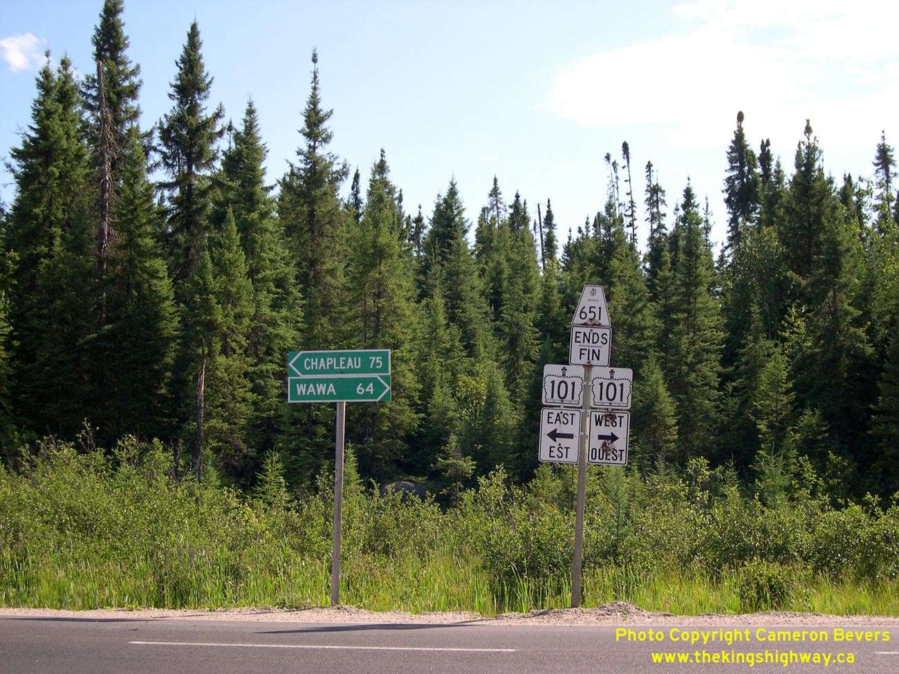
it ends at the small community of Missanabie. See an Enlarged Photo Here. (Photograph taken on July 16, 2007 - © Cameron Bevers) Right - Directional signs and highway route marker assembly at the south terminus of Hwy 651 at the Hwy 101 Junction. See an Enlarged Photo Here. (Photograph taken on July 16, 2007 - © Cameron Bevers) 

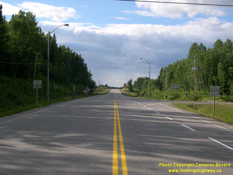
Left - Facing east along Hwy 101 from the Hwy 651 Junction. See an
Enlarged Photo Here. (Photograph taken on July 16, 2007 - © Cameron Bevers) Right - Approaching the Hwy 651 Junction on Hwy 101, facing west towards Wawa. The route of Hwy 101 from Chapleau to Wawa is a relatively new highway link in the Ontario provincial highway system. The route was officially opened to traffic on November 1, 1966, after nearly a decade of construction. See an Enlarged Photo Here. (Photograph taken on July 16, 2007 - © Cameron Bevers) 

Left - Facing east along Hwy 101 towards Chapleau at the Prairie Bee River Bridge, located about 83 km east of Wawa. See an
Enlarged Photo Here. (Photograph taken on July 16, 2007 - © Cameron Bevers) Right - Southern side of the Prairie Bee River Bridge on Hwy 101. This four-span timber trestle structure with a laminated timber deck was completed in 1964. See an Enlarged Photo Here. (Photograph taken on July 16, 2007 - © Cameron Bevers) 

Left - Northern side of the Prairie Bee River Bridge on Hwy 101 between Wawa and Chapleau. See an
Enlarged Photo Here. (Photograph taken on July 16, 2007 - © Cameron Bevers) Right - Facing west along Hwy 101 towards Wawa at the Prairie Bee River Bridge. See an Enlarged Photo Here. (Photograph taken on July 16, 2007 - © Cameron Bevers) 

Left - Steel and concrete handrail design on the Prairie Bee River Bridge on Hwy 101. See an
Enlarged Photo Here. (Photograph taken on July 16, 2007 - © Cameron Bevers) Right - Facing south along Hwy 101 & Hwy 129, about 5 km south of Chapleau. See an Enlarged Photo Here. (Photograph taken on July 16, 2007 - © Cameron Bevers) 

Left - Dual Hwy 101 & Hwy 129 route markers south of Chapleau. These two highways share a short concurrent route for approximately 8 km. See an
Enlarged Photo Here. (Photograph taken on July 16, 2007 - © Cameron Bevers) Right - Highway route marker assembly at the Hwy 101 East Junction on southbound Hwy 129 near Chapleau. Hwy 101 and Hwy 129 share a brief overlapped route before parting ways again about 11 km south of Chapleau. See an Enlarged Photo Here. (Photograph taken on July 16, 2007 - © Cameron Bevers) 
Left - Facing south along Hwy 101 & Hwy 129 from the Hwy 101 East Junction near Chapleau. Two destinations are provided on the mileage sign. Wawa lies at
the western terminus of Hwy 101, while Thessalon is located at the southern terminus of Hwy 129. See an
Enlarged Photo Here. (Photograph taken on July 16, 2007 - © Cameron Bevers) Right - Just south of Chapleau, Hwy 101 turns and resumes its route east towards Timmins. At the junction, Hwy 129 continues north for 3 km into Chapleau. See an Enlarged Photo Here. (Photograph taken on July 16, 2007 - © Cameron Bevers) 

Left - Facing east along Hwy 101 towards Timmins from the Hwy 129 Junction near Chapleau. See an
Enlarged Photo Here. (Photograph taken on July 16, 2007 - © Cameron Bevers) Right - Directional signs and highway route marker assembly at the Hwy 129 and Hwy 101 East Junction, 3 km south of Chapleau. See an Enlarged Photo Here. (Photograph taken on July 16, 2007 - © Cameron Bevers) 

Left - Facing south along Hwy 129 towards the Hwy 101 Junction near Chapleau. See an
Enlarged Photo Here. (Photograph taken on July 16, 2007 - © Cameron Bevers) Right - View of Hwy 129, facing north from the Hwy 101 East Junction. The route of Hwy 129 ends 3 km ahead in Chapleau. See an Enlarged Photo Here. (Photograph taken on July 16, 2007 - © Cameron Bevers)
Continue on to King's Highway 101 Photos: Chapleau to Hwy 11
|
|---|
Links to Adjacent King's Highway Photograph Pages:
Back to King's Highway 100 (#2) Photos /
King's Highway 101 History /
On to King's Highway 102 (#1) Photos
Ontario Highway History - Main Menu / Back to List of Highways Website contents, photos & text © 2002-2026, Cameron
Bevers (Webmaster) - All Rights Reserved / Contact Me
|
|---|