
| 
| |
|
|
This page contains present day photos (Year 2000 to date) of Ontario's King's Highway 115, arranged by location from the
Highway 28 Interchange at Springville northerly to the Highway 7 East Junction in Peterborough. All photographs displayed on this page were taken by the Webmaster
(Cameron Bevers), unless specifically noted otherwise. Click on any thumbnail to see a larger image!
Please note that all photographs displayed on this
website are protected by copyright. These photographs must not be reproduced, published,
electronically stored or copied, distributed, or posted onto other websites without
my written permission. If you want to use photos from this website, please
email me first for permission. Thank-you!
|
|---|
|
Page 5: Present Day King's Highway 115 Photographs (Hwy 28 to Peterborough)

Left - Facing north towards Fowlers Corners at the Hwy 28 Interchange on Hwy 7 & Hwy 115 at Springville, southwest of Peterborough. Prior to the extension
of Hwy 115 from Springville to Peterborough in 1978, Hwy 115 used to end at this interchange. Until 1984, Hwy 28 used to continue straight through (north) towards
Five Mile Corners, located south of Fowlers Corners. Hwy 28 was rerouted southwest of Peterborough in the 1980s and was signed concurrently with Hwy 115 between 1984
and 2003. Originally, Hwy 7 did not pass through this interchange at all. However, the Hwy 7 designation was applied to the highway through Springville in 2003, in order
to close a gap left over when a section of Hwy 7 (North Monaghan Parkway and Sir Sandford Fleming Drive) was downloaded to the County of Peterborough in 1997. See an
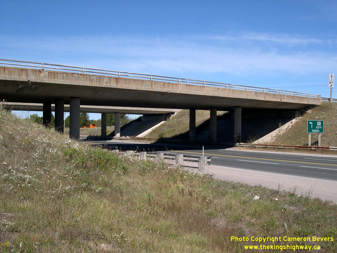
Enlarged Photo Here. (Photograph taken on September 23, 2007 - © Cameron Bevers) Right - Dual underpass structures carry the freeway over Hwy 28. The northbound Hwy 115 structure is much older than the southbound Hwy 115 structure, due to the fact that Hwy 115 was constructed as a staged freeway through this interchange. Hwy 115 was initially built as an undivided two-lane highway, but was later expanded to a four-lane freeway in the mid-1980s. Click here to see a Historical 1972 Photo of the partially-completed Hwy 28 Interchange on Hwy 115, showing the former northern terminus of Hwy 115. See an Enlarged Photo Here. (Photograph taken on September 23, 2007 - © Cameron Bevers) 

Left - Northbound Hwy 115 underpass at the Hwy 28 Interchange near Peterborough. This three-span post-tensioned concrete structure was completed in 1966. See
an Enlarged Photo Here. (Photograph taken on September 23, 2007 - © Cameron Bevers) Right - Date stamp (1966) and structure identification number (Site #21-338) on the northbound Hwy 115 structure at the Hwy 28 Interchange. See an Enlarged Photo Here. (Photograph taken on September 23, 2007 - © Cameron Bevers) 

Left - Western side of the northbound Hwy 115 structure at the Hwy 28 Interchange at Springville. See an
Enlarged Photo Here. (Photograph taken on September 23, 2007 - © Cameron Bevers) Right - Southbound Hwy 115 structure at the Hwy 28 Interchange. This three-span post-tensioned concrete structure was completed in 1985. See an Enlarged Photo Here. (Photograph taken on September 23, 2007 - © Cameron Bevers) 

Left - Date stamp (1985) on the southbound Hwy 115 structure at the Hwy 28 Interchange. See an
Enlarged Photo Here. (Photograph taken on September 23, 2007 - © Cameron Bevers) Right - Facing north along Hwy 7 & Hwy 115 (Formerly Hwy 28 & Hwy 115) towards Peterborough from the Hwy 28 Interchange near Springville. See an Enlarged Photo Here. (Photograph taken on September 23, 2007 - © Cameron Bevers) 

Left - Green guide signs at the Airport Road Interchange near Peterborough, marking the entrance ramp to Hwy 7 East & Hwy 115 North. These two highways
share a concurrent overlapped route for about 13 km near Peterborough. Both Ottawa and Peterborough are signed as destination control cities at this interchange. See
an Enlarged Photo Here. (Photograph taken on September 25, 2021 - © Cameron Bevers) Right - Western side of the Airport Road Overpass on Hwy 7 & Hwy 115. This two-span post-tensioned concrete structure was completed in 1985. See an Enlarged Photo Here. (Photograph taken on September 25, 2021 - © Cameron Bevers) 

Left - Date stamp (1985) and structure identification number (Site #26-177) on the Airport Road Overpass on Hwy 7 & Hwy 115 southwest of Peterborough. See an
Enlarged Photo Here. (Photograph taken on September 25, 2021 - © Cameron Bevers) Right - Facing south across the Airport Road Overpass on Hwy 7 & Hwy 115. Airport Road is also known as Peterborough County Road 11. See an Enlarged Photo Here. (Photograph taken on September 25, 2021 - © Cameron Bevers) 

Left - Green guide signs at the Airport Road Interchange near Peterborough, marking the entrance ramp to Hwy 7 West and Hwy 115 South. Toronto is logically
shown as the destination control city on this sign, even though Hwy 7 does not enter (and historically has never entered) the City of Toronto. However, if one is
departing from Peterborough via this freeway, it is unlikely that your destination is anything other than the Greater Toronto Area (GTA). See an
Enlarged Photo Here. (Photograph taken on September 25, 2021 - © Cameron Bevers) Right - Dusk over Hwy 7 & Hwy 115, facing south from the Airport Road Interchange near Peterborough. See an Enlarged Photo Here. (Photograph taken on September 25, 2021 - © Cameron Bevers) 

Left - Facing north along Hwy 7 & Hwy 115 from the Airport Road Overpass near Peterborough. See an
Enlarged Photo Here. (Photograph taken on September 25, 2021 - © Cameron Bevers) Right - Airport Road Overpass on Hwy 7 & Hwy 115, facing north towards Peterborough. See an Enlarged Photo Here. (Photograph taken on September 25, 2021 - © Cameron Bevers) 

Left - Eastern side of the Airport Road Overpass on Hwy 7 & Hwy 115 near Peterborough. See an
Enlarged Photo Here. (Photograph taken on September 25, 2021 - © Cameron Bevers) Right - Facing east along Charlotte Street (Former Hwy 28 & Hwy 115) at Monaghan Road (Former Hwy 7B). Prior to 1997, Hwy 28 turned left at this intersection and headed north along Monaghan Road concurrently with Hwy 7B. The route of Hwy 115 reached its pre-1997 northern terminus at this junction. The route of Hwy 7B also continued south from here along Monaghan Road to Lansdowne Street, where the route of Hwy 7B turned easterly towards the Peterborough Bypass and Ottawa. As a result of the downloading of various highways and revocation of municipal connecting links in the Peterborough area in 1997-1998, there are no longer any provincial highways which pass through the urbanized sections of Peterborough. See an Enlarged Photo Here. (Photograph taken on July 9, 2006 - © Cameron Bevers) 

Left - Facing west along the Peterborough Bypass (Hwy 7 & Hwy 115) from the Otonabee River Bridge. See an
Enlarged Photo Here. (Photograph taken on August 25, 2012 - © Cameron Bevers) Right - View of the Otonabee River Bridge on the Peterborough Bypass (Hwy 7 & Hwy 115), facing south. See an Enlarged Photo Here. (Photograph taken on August 25, 2012 - © Cameron Bevers) 

Left - Dual structures over the Otonabee River on the Peterborough Bypass (Hwy 7 & Hwy 115). As originally constructed, the Peterborough Bypass was an
undivided two-lane highway. The bridge seen at right is the original Peterborough Bypass structure, which was completed in 1960. When the Peterborough Bypass was
expanded from two to four lanes in the 1980s, a new structure was built at left to carry westbound traffic only. The original structure at right was then converted to
carry eastbound traffic only. See an Enlarged Photo Here. (Photograph taken on August 25, 2012 - © Cameron Bevers) Right - Date stamp (1983) and structure identification number (Site #26-61) on the westbound Otonabee River structure on Hwy 7 & Hwy 115 in Peterborough. See an Enlarged Photo Here. (Photograph taken on August 25, 2012 - © Cameron Bevers) 

Left - Eastbound Peterborough Bypass structure over the Otonabee River. This complicated structure was completed in 1960. It consists of a three-span haunched
steel plate girder main structure over the Otonabee River and Trent-Severn Waterway along with eight steel beam approach spans. See an
Enlarged Photo Here. (Photograph taken on August 25, 2012 - © Cameron Bevers) Right - Westbound Peterborough Bypass structure over the Otonabee River. This five-span trapezoidal steel box girder structure was completed in 1983. See an Enlarged Photo Here. (Photograph taken on August 25, 2012 - © Cameron Bevers) 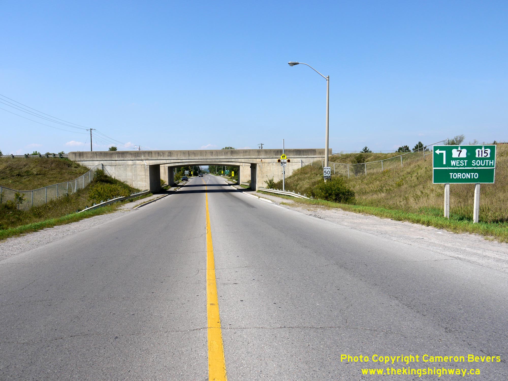

Left - Approaching the dual underpasses at Bensfort Road and the Peterborough Bypass (Hwy 7 & Hwy 115), facing north. See an
Enlarged Photo Here. (Photograph taken on August 25, 2012 - © Cameron Bevers) Right - Facing south along Bensfort Road approaching the dual underpasses at the Peterborough Bypass. See an Enlarged Photo Here. (Photograph taken on August 25, 2012 - © Cameron Bevers) 

Left - Date stamp (1984) and structure identification number (Site #26-175) on the Bensfort Road Underpass on Hwy 7 & Hwy 115 in Peterborough. See an
Enlarged Photo Here. (Photograph taken on August 25, 2012 - © Cameron Bevers) Right - Ground-mounted freeway guide sign for Hwy 7 East at the end of the Peterborough Bypass. Although Hwy 7 continues east from Peterborough towards Norwood, Madoc and eventually Ottawa, Hwy 115 reaches its northern terminus at the traffic signals just ahead. See an Enlarged Photo Here. (Photograph taken on September 23, 2007 - © Cameron Bevers) 

Left - Eastern end of the Peterborough Bypass (Hwy 7 & Hwy 115) approaching Lansdowne Street. At one time, Lansdowne Street west of this intersection was a
signed business route (Hwy 7B) which passed through Peterborough. After a rather circuitous loop, Peterborough's Hwy 7B connected back to Hwy 7 west of the city at
Fowlers Corners. See an Enlarged Photo Here. (Photograph taken on September 23, 2007 - © Cameron Bevers) Right - Green guide signs on westbound Hwy 7 approaching the Peterborough Bypass and Lansdowne Street (Former Hwy 7B). See an Enlarged Photo Here. (Photograph taken on September 23, 2007 - © Cameron Bevers) 

Left - Ground-mounted guide sign marking the former route of Hwy 7B into Peterborough via Lansdowne Street. The route of Hwy 7B was decommissioned as a King's
Highway in 1997, although the green patch placed over the old Hwy 7B crown is still quite obvious. This sign was replaced shortly after this photo was taken in 2007.
See an Enlarged Photo Here. (Photograph taken on September 23, 2007 - © Cameron Bevers) Right - Facing west along Hwy 7 approaching the Peterborough Bypass Junction. At the traffic signals, Hwy 7 turns left and begins a concurrent overlapped route with Hwy 115. Up until 1997, motorists could also follow the Hwy 7B Business Route through Peterborough. Although much longer that the route offered by Hwy 7, Peterborough's Hwy 7B did form a complete loop. It eventually reconnected back to Hwy 7 at Fowlers Corners. The ramp seen joining in at left carries traffic from the Peterborough Bypass to eastbound Hwy 7. See an Enlarged Photo Here. (Photograph taken on September 23, 2007 - © Cameron Bevers) 

Left - View of the eastern terminus of the Peterborough Bypass (Hwy 7 & Hwy 115), facing west from Lansdowne Street. See an
Enlarged Photo Here. (Photograph taken on September 23, 2007 - © Cameron Bevers) Right - Green guide signs on eastbound Lansdowne Street (Formerly Hwy 7B) approaching the Peterborough Bypass. Although it isn't indicated on these signs, traffic heading straight through at this intersection will join Hwy 7 East to Ottawa. See an Enlarged Photo Here. (Photograph taken on September 23, 2007 - © Cameron Bevers) 
Above - Facing east along Hwy 7 towards Norwood from the Hwy 115 and Former Hwy 7B Junction in Peterborough. See an
Enlarged Photo Here. (Photograph taken on September 23, 2007 - © Cameron Bevers)
More King's Highway 115 Photographs Coming Soon!
|
|---|
Links to Adjacent King's Highway Photograph Pages:
Back to King's Highway 114 Photos /
King's Highway 115 History /
On to King's Highway 116 Photos
Ontario Highway History - Main Menu / Back to List of Highways Website contents, photos & text © 2002-2026, Cameron
Bevers (Webmaster) - All Rights Reserved / Contact Me
|
|---|