
| 
| |
|
|
This page contains historical photos of Ontario's King's Highway 11 and the Ferguson Highway dating from 1920 to 1939. All
photographs displayed on this page were taken by the Ontario Ministry of Transportation, unless specifically noted otherwise. Historical photographs are arranged in
approximate chronological order. Click on any thumbnail to see a larger image!
Please note that all photographs displayed on this
website are protected by copyright. These photographs must not be reproduced, published,
electronically stored or copied, distributed, or posted onto other websites without
my written permission. If you want to use photos from this website, please
email me first for permission. Thank-you!
|
|---|
|
Page 1: Historical King's Highway 11 Photographs (1920 to 1939)

Above - Completed asphaltic concrete pavement approaching the Grand Trunk Railway Subway on the Toronto-Barrie Provincial Highway (Hwy 11) south of Aurora.
This two-lane highway grade separation was completed in 1922, under the Department of Public Highways of Ontario's (DPHO's) Contract #471. This new grade separation
also provided space for the relocated Toronto & York Radial Railway, which previously crossed over the Grand Trunk Railway via an overhead bridge located a short
distance to the east. This railway subway was reconstructed in 1940 in order to allow for a four-lane highway pavement underneath the structure. See an
Enlarged Photo Here. Photo taken in 1922. (Photo courtesy of Ontario Ministry of Transportation - © King's Printer for Ontario, 1922) 
Above - Construction crew on the Toronto-Barrie Provincial Highway (Hwy 11) at the foot of the Holland Landing Hill in 1924. This asphalt macadam pavement was
built along Hwy 11 by the A.E. Jupp Construction Company, under DPHO Contract #1054. The asphalt binder on this contract was supplied by the Imperial Oil Company and
was applied by the Bituminous Spraying & Construction Company under subcontract. See an
Enlarged Photo Here. Photo taken in July 1924. (Photo courtesy of Ontario Ministry of Transportation - © King's Printer for Ontario, 2004) 
Above - Completed bituminous penetration pavement along the Toronto-Barrie Provincial Highway (Hwy 11) near Holland Landing. See an
Enlarged Photo Here. Photo taken in 1924. (Photo courtesy of Ontario Ministry of Transportation - © King's Printer for Ontario, 1924) 
Above - Surveyors using snowshoes in winter to mark out the proposed route of the North Bay-Cobalt Trunk Road (the Ferguson Highway). See an
Enlarged Photo Here. Photo taken in 1925. (Photo courtesy of Ontario Department of Northern Development - © King's Printer for Ontario, 1925) 
Above - Cleared right-of-way for the proposed North Bay-Cobalt Trunk Road (the Ferguson Highway). It was not possible to drive up to Northeastern Ontario
prior to the construction of this trunk road, as the road system ended near North Bay and did not connect to any points further north. See an
Enlarged Photo Here. Photo taken in 1925. (Photo courtesy of Ontario Department of Northern Development - © King's Printer for Ontario, 1925) 
Above - Department of Northern Development Work Camp in Northern Ontario in 1925. It is believed that this work camp was situated along the North Bay-Cobalt
Road, which was renamed the Ferguson Highway in honour of Ontario Premier G.H. Ferguson upon the trunk road's completion in July 1927. Once the Department of Highways
of Ontario (DHO) took over responsibility for Northern Ontario's main trunk roads in 1937, the Ferguson Highway was designated as a northerly extension of King's
Highway 11 from Severn Bridge to Cochrane and then northwesterly to Hearst. See an
Enlarged Photo Here. Photo taken in 1925. (Photo courtesy of Ontario Department of Northern Development - © King's Printer for Ontario, 1925) 

Left - New mixed macadam pavement with an asphaltic concrete top course on Hwy 11 at "The Pines" near Stroud in 1926. Under Contract #1926-122, 7 3/4 miles of
new pavement was constructed south of Barrie between Fennell's Corner and Stroud. See an
Enlarged Photo Here. Photo taken in 1926. (Photo courtesy of Ontario Ministry of Transportation - © King's Printer for Ontario, 1926) Right - View of Hwy 11 north of Fennell's Corner, showing the new pavement constructed under Contract #1926-122. Note the white-painted boulders placed around the outside of the highway curve. This type of treatment was commonly used on early highways to delineate sharp curves. See an Enlarged Photo Here. Photo taken in 1926. (Photo courtesy of Ontario Ministry of Transportation - © King's Printer for Ontario, 1926) 
Above - North Bay-Cobalt Road (the Ferguson Highway) shortly after completion in 1927. While the Ferguson Highway was gravelled for its entire length between
North Bay and Cobalt, some parts of the highway were quite primitive with a narrow road surface and winding alignment. Nevertheless, the completion of the Ferguson
Highway from North Bay to Cobalt was a major accomplishment, as it finally allowed contiguous road access from the south to "New Ontario" - the vast agricultural area
which extended from Cobalt and New Liskeard northwesterly to Cochrane, Kapuskasing and Hearst. Prior to the Ferguson Highway's completion in 1927, motorists wishing
to travel by motorcar to Northeastern Ontario had to arrange for transport of their vehicle north by railway from North Bay to Cobalt, where the road system began
once again. See an Enlarged Photo Here. Photo taken in 1927. (Photo courtesy of Ontario Department of Northern Development - © King's Printer for Ontario, 1927) 
Above - "Wild Goose Crossing" on the Ferguson Highway in 1927. While the exact location of the bridge crossing was not identified on the photo, it is believed
that this long timber trestle and truss bridge spanned the Englehart River on the Ferguson Highway between Englehart and Charlton. This part of the Old Ferguson
Highway was later bypassed by the current route of Hwy 11. Today, the highway between Englehart and Charlton is part of Secondary Highway 560. See an
Enlarged Photo Here. Photo taken in 1927. (Photo courtesy of Ontario Department of Northern Development - © King's Printer for Ontario, 1927) 

Left - Circa 1927 postcard view of the Ferguson Highway (Hwy 11) at the Gravenhurst Welcome Arch. This arch was constructed by the Gravenhurst Board of Trade
in 1925. It was one of many municipal welcome arches constructed at the entrances to towns and cities in Northern Ontario. The arch was built at a time where travel
to Muskoka by motorcar was still very much in its infancy. Nevertheless, the Gravenhurst Board of Trade determined that the arch provided a portal (quite literally)
to advertise the town's amenities to affluent travellers. This view, which shows the more-familiar "entrance" side of the arch was visible by northbound traffic on
the Ferguson Highway. See an Enlarged Photo Here. Photo taken circa 1927. (Photo courtesy of the Photogelatine Engraving Company Ltd, Ottawa) Right - Circa 1927 postcard view of the opposing (southbound) side of the Gravenhurst Welcome Arch on the Ferguson Highway (Hwy 11), facing south towards Orillia. At that time, the Ferguson Highway was really just a winding gravel road south of Gravenhurst - certainly a world apart from the four-lane expressway which Hwy 11 has become today! Careful observers may note that swastikas appear on both sides of the welcome arch. While the swastika has extremely negative connotations today, it should be noted that this ancient symbol was commonly used in artwork and various architecture in the early 20th Century, as it was intended to represent good luck. At the time the welcome arch was constructed in 1925, this symbol was also prominently displayed on many of Muskoka's famous summer resorts. However, the swastika's use in North America rapidly declined by the end of the 1930s, when the symbol's positive ancient meaning was forever tarnished due to its association with Nazi Germany and the atrocities which resulted from that regime. Although the Gravenhurst Welcome Arch has been renovated several times with different messages and various layouts over the past century, the current iteration of the arch is a close replica of the original one built in 1925. See an Enlarged Photo Here. Photo taken circa 1927. (Photo courtesy of the Photogelatine Engraving Company Ltd, Ottawa) 

Left - Front cover of a well-used Ferguson Highway Travel Booklet from 1928. These booklets were issued as a travel guide to tourists by the Department of
Northern Development. The booklet contained information about the Ferguson Highway, along with information about attractions and destinations located along the
newly-built highway. See an Enlarged Photo Here. (Photo courtesy of Ontario Department of Northern Development - © King's Printer for Ontario, 1928) Right - Back cover of the 1928 Ferguson Highway Travel Booklet. See an Enlarged Photo Here. (Photo courtesy of Ontario Department of Northern Development - © King's Printer for Ontario, 1928) 

Left - Tomiko River Roadside Park on the Ferguson Highway (Hwy 11) at Tilden Lake, located about 22 miles north of North Bay. This was one of several tourist
campgrounds built along the Ferguson Highway during the late 1920s for the convenience of motorists using the new trunk road. While the portion of the Tomiko River
Roadside Park seen here along the eastern side of Hwy 11 has long since closed, the portion of the park which fronted onto Elbow Lake on the western side of Hwy 11 is
still in operation today. This small roadside park has thus been greeting motorists on Hwy 11 for nearly a century! See an
Enlarged Photo Here. (Photo courtesy of Ontario Department of Northern Development - © King's Printer for Ontario, 1928) Right - Fireplace at one of the Tomiko River Park's campsites on the Ferguson Highway (Hwy 11). See an Enlarged Photo Here. (Photo courtesy of Ontario Department of Northern Development - © King's Printer for Ontario, 1928) 


Left - Facing south along the Ferguson Highway (Hwy 11) approaching Jumping Caribou Lake. See an
Enlarged Photo Here. Photo taken in 1928. (Photo courtesy of Ontario Department of Northern Development - © King's Printer for Ontario, 1928) Centre - View of the Ferguson Highway (Hwy 11) south of South River. See an Enlarged Photo Here. Photo taken in 1928. (Photo courtesy of Ontario Department of Northern Development - © King's Printer for Ontario, 1928) Right - View of the Ferguson Highway (Hwy 11) at Christy Lake, located about 9 miles south of Temagami. See an Enlarged Photo Here. Photo taken in 1928. (Photo courtesy of Ontario Department of Northern Development - © King's Printer for Ontario, 1928) 
Above - Completed Hogg's Hollow Bridge on a diversion of Hwy 11 north of Toronto near York Mills. This massive steel deck truss structure was built by the DPHO
under Contract #1928-01. The viaduct carried Yonge Boulevard (a diversion of Hwy 11) over the Don River. Constructed by the Goldie Construction Company Ltd, this
eight-span bridge had a total length of 1,124 feet and a roadway width between curbs of 54 feet. The trusses themselves were manufactured by the Canadian Bridge
Company Ltd of Walkerville, Ontario, which were perched atop large concrete piers which rose triumphantly above the valley floor. At its maximum elevation, the bridge
deck had a 128-foot rise above ground level. Completed in approximately 9 months, the bridge cost $715,000 to build (in 1928 Dollars), which is roughly equivalent to
$12.3 Million in 2023 Dollars. More than 1,500 people came out to the watch the official bridge opening by Ontario's Minister of Public Works, George S. Henry, on
January 5, 1929. Today, this bridge carries the eastbound Hwy 401 Express Lanes across Hogg's Hollow, while the other three Hwy 401 roadways are carried on separate
high-level viaducts which were built across the valley during the 1960s. See an
Enlarged Photo Here. Photo taken in 1929. (Photo courtesy of Ontario Ministry of Transportation - © King's Printer for Ontario, 1929) 

Left - Gravel stockpile in Muskoka for the proposed surfacing of the Ferguson Highway north of the Severn River. With increased tourism and commercial vehicle
traffic, the need came about to lay a more permanent surface along the Ferguson Highway. Between 1929 and 1931, the Ferguson Highway was surfaced with a retread
pavement, which offered motorists a more comfortable ride and eliminated the need for maintenance crews to continuously grade the road. See an
Enlarged Photo Here. Photo taken in 1930. (Photo courtesy of Ontario Department of Northern Development - © King's Printer for Ontario, 1930) Right - New southern entrance to Bracebridge on the Ferguson Highway approaching the "Silver Bridge" in 1930, shortly after completion. This impressive steel through truss structure over the Muskoka River still stands today on Ecclestone Drive (Old Hwy 11) approaching Downtown Bracebridge. See an Enlarged Photo Here. Photo taken in 1930. (Photo courtesy of Ontario Department of Northern Development - © King's Printer for Ontario, 1930) 
Above - Circa 1930 postcard view of the Ferguson Highway (Hwy 11) at Lowell Lake. This beautiful lake scene once greeted early travellers as they headed north
along the Ferguson Highway towards Temagami. Few early photos capture the Ferguson Highway's rugged beauty as vividly as this photo portrays. There was a time when
only the most adventurous of motorists would travel this crude, narrow ribbon of gravel, as it meandered around the remote lakes and through the thick forests between
North Bay and Cobalt. As the motor age arrived, the Ferguson Highway was quickly upgraded into an all-season gravel highway and was eventually paved. The final gravel
section along Hwy 11 between North Bay and New Liskeard was paved in 1952, exactly 25 years after the Ferguson Highway was initially opened to traffic in 1927. Since
that time, Hwy 11 has become one of Ontario's most important King's Highways. As part of the reconstruction of the Old Ferguson Highway in the late 1930s, Hwy 11 was
relocated onto an improved alignment a short distance to the west in 1939. This new Hwy 11 route deviated from the Old Ferguson Highway between Herridge Lake and
Lowell Lake and extended northerly to the south entrance to Temagami. Although it has been hidden from through traffic using Hwy 11 since 1939, this view of Lowell
Lake lies just east of the current highway on Lowell Lake Road (Old Hwy 11) about 7 km south of Temagami. See an
Enlarged Photo Here. Photo taken circa 1930. (Photo courtesy of MacLean Photo) 

Left - Circa 1930 postcard view of the Ferguson Highway (Hwy 11) at Jumping Caribou Lake. See an
Enlarged Photo Here. (Photo courtesy of the Ontario Publicity Bureau - Published by Valentine-Black Company Ltd, Toronto) Right - Circa 1930 coloured postcard view of the Ferguson Highway (Hwy 11) approaching the Tomiko River Bridge, about 22 miles north of North Bay. This postcard shows the Department of Northern Development's popular Tomiko River Campground, located at Tilden Lake. With its small parking area already full, this photo from the early 1930s clearly illustrates the growing popularity of these roadside parks by tourists. The postcard also shows the original Tomiko River Bridge in the background. This two-span creosoted timber truss bridge was replaced by a creosoted timber trestle bridge on an improved highway alignment in 1936. See an Enlarged Photo Here. Photo taken circa 1930. (Photo courtesy of the Ontario Publicity Bureau - Published by Valentine-Black Company Ltd, Toronto) 

Left - New concrete pavement on Hwy 11, facing south towards Barrie from Crown Hill. This concrete pavement was constructed in 1930, under Contract #1930-06.
See an Enlarged Photo Here. Photo taken in 1931. (Photo courtesy of Ontario Ministry of Transportation - © King's Printer for Ontario, 1931) Right - View of Hwy 11 south of Orillia showing the new concrete pavement constructed under Contract #1931-12. With the completion of this 4.7-mile section of concrete highway south of Orillia in 1931, motorists were afforded a paved highway link between Orillia and Toronto. Perhaps more importantly, the completion of this contract removed the final gravel section along Hwy 11 between Toronto and the highway's pre-1937 northern terminus at the Severn River. With the Department of Northern Development also upgrading the Ferguson Highway north of Severn Bridge, motorists could travel as far north as Huntsville on a hard-surfaced highway by the end of 1931. See an Enlarged Photo Here. Photo taken in 1931. (Photo courtesy of Ontario Ministry of Transportation - © King's Printer for Ontario, 1931) 

Left - Winter snow clearing operations along Hwy 11 between Barrie and Orillia in 1931. While highway snowplowing may be viewed today as a ubiquitous and
mundane winter scene, there was a time when the sight of a winter snow clearing operation along an Ontario highway was a brand new thing. When Ontario's Provincial
Highway system was first established in the closing years of World War I, the highways were not necessarily plowed in winter. They would be closed seasonally as
the weather conditions dictated. It wasn't until the mid-1920s that serious efforts were made to keep highways open all winter. By the Winter of 1929-1930, the DPHO
had secured enough snow-clearing equipment and truck fleets to keep 1,800 miles of highways out of the nearly 2,500-mile Provincial Highway System open to traffic
throughout the winter season. Winter maintenance costs that season, including sanding operations, amounted to some $310,000 (in 1929 Dollars), which is the equivalent
of about $5.3 Million in 2023 Dollars. See an Enlarged Photo Here. Photo taken in 1931. (Photo courtesy of Ontario Ministry of Transportation - © King's Printer for Ontario, 1931) Right - Snowplows in operation along Hwy 11 between Barrie and Orillia. See an Enlarged Photo Here. Photo taken in 1931. (Photo courtesy of Ontario Ministry of Transportation - © King's Printer for Ontario, 1931) 
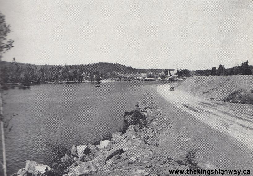
Above - Circa 1932 view of Hwy 11 at Beaver Creek north of Orillia. See an
Enlarged Photo Here. (Photo from Cameron Bevers' historical photograph collection - Original photographer unknown) 
Above - Construction of a new steel deck truss structure across the Englehart River on the Ferguson Highway (Hwy 11) at the southern entrance to Englehart in
1932. Once completed, this new viaduct allowed traffic to pass directly across the valley. It eliminated the steep grades and winding alignment on the original route
of the Ferguson Highway approaching Englehart. See an Enlarged Photo Here. Photo taken in
1932. (Photo courtesy of Ontario Department of Northern Development - © King's Printer for Ontario, 1932) 
Above - Completed Englehart Bridge on the Ferguson Highway (Hwy 11), facing southeast towards New Liskeard. This massive steel deck truss structure was the
largest bridge built by the Department of Northern Development up until that point, with a total bridge length of 801 feet. The bridge crossed a deep valley which
had long been an obstacle to both highway builders along with the railway builders who came before them. This impressive highway structure stood until the mid-1970s,
when it was replaced with a new bridge. See an Enlarged Photo Here. Photo taken in 1932. (Photo courtesy of Ontario Department of Northern Development - © King's Printer for Ontario, 1932) 

Left - Widened three-lane pavement on Hwy 11 between Richmond Hill and Aurora in 1934. This widened section of Hwy 11 was Ontario's first multi-lane highway.
It was constructed under Contract #1934-27, when a 10-foot lane was constructed along the eastern (northbound) side of the existing highway. The existing two-lane
highway was also resurfaced as part of this contract, with pavement zone striping introduced in order to mark the three separate traffic lanes. See an
Enlarged Photo Here. Photo taken in 1934. (Photo courtesy of Ontario Ministry of Transportation - © King's Printer for Ontario, 1934) Right - View of Hwy 11 between Richmond Hill and Aurora showing the widened three-lane pavement. About 7 1/2 miles of Hwy 11 was widened under this project. Although this was Ontario's first highway expansion project, it certainly was not the last. Since the 1930s, many miles of Ontario's King's Highways have been expanded to meet the needs of our growing population and robust economy. See an Enlarged Photo Here. Photo taken in 1934. (Photo courtesy of Ontario Ministry of Transportation - © King's Printer for Ontario, 1934) 

Left - Circa 1935 postcard view of the Ferguson Highway (Hwy 11) approaching the Callander Gateway Sign. See an
Enlarged Photo Here. (Photo courtesy of Evans & Bowman Publishing, Walshingham) Right - Circa 1935 coloured postcard view of the Ferguson Highway (Hwy 11) in the Temagami Provincial Forest Reserve approaching Jumping Caribou Lake. See an Enlarged Photo Here. (Photo courtesy of the Photogelatine Engraving Company Ltd, Ottawa) 
Above - Circa 1937 coloured postcard view of Hwy 11 at "The Pines" near Stroud, south of Barrie. See an
Enlarged Photo Here. (Photo courtesy of the Photogelatine Engraving Company Ltd, Ottawa) 

Left - Rock cut under construction on Hwy 11 about 1 mile north of Temagami under Contract #1937-282, facing north towards Latchford. See an
Enlarged Photo Here. Photo taken on March 4, 1938. (Photo courtesy of Ontario Ministry of Transportation - © King's Printer for Ontario, 1938) Right - "Curve and Stop Hill" on Hwy 11, located 2 miles south of Temagami. See an Enlarged Photo Here. Photo taken in 1938. (Photo courtesy of Ontario Ministry of Transportation - © King's Printer for Ontario, 1938) 

Left - New Hwy 11 alignment and improved grade at Thibeault Hill in 1938, facing south towards North Bay. Under Contract #1937-42, Hwy 11 was relocated onto an
improved alignment at the northern entrance to North Bay. About 5 miles of grading took place, including the excavation of the Thibeault Hill Cut seen here. The Old
Ferguson Highway's route up Thibeault Hill was subsequently abandoned. It lies a short distance to the east of the current route of Hwy 11. See an
Enlarged Photo Here. Photo taken on August 24, 1938. (Photo courtesy of Ontario Ministry of Transportation - © King's Printer for Ontario, 1938) Right - View of the new Tomiko River Bridge on Hwy 11 in 1938, facing south towards North Bay. This newly-built creosoted timber trestle bridge was constructed under Contract #1936-131, which was being administered by the Department of Highways of Ontario (DHO) in advance of the Department's assumption of the Ferguson Highway as an extension of King's Highway 11 the following year. This new bridge was built on an improved alignment and replaced the two-span creosoted timber truss bridge over the Tomiko River seen in this Circa 1930 Photo. See an Enlarged Photo Here. Photo taken on August 24, 1938. (Photo courtesy of Ontario Ministry of Transportation - © King's Printer for Ontario, 1938) 

Left - New rock cut and curve on Hwy 11 south of Latchford, facing north. Grading was completed along Hwy 11 from Latchford southerly for 6 miles under
Contract #1937-47, which resulted in a wider road surface and well-designed horizontal highway curves such as this one. Considering how long ago it was built, the
revised alignment of Hwy 11 was designed to very high standards. By comparison, the Old Ferguson Highway's alignment generally followed a path of least resistance,
which was greatly influenced by the topography of the surrounding land. Accordingly, sharp curves, steep grades and a winding alignment were the rule rather than the
exception along the old highway. See an Enlarged Photo Here. Photo taken on August 25, 1938. (Photo courtesy of Ontario Ministry of Transportation - © King's Printer for Ontario, 1938) Right - View of Hwy 11 about 1/2 mile north of Temagami, facing north. See an Enlarged Photo Here. Photo taken on August 25, 1938. (Photo courtesy of Ontario Ministry of Transportation - © King's Printer for Ontario, 1938) 
Left - Realigned section of Hwy 11 showing a new rock cut north of James Lake in 1938. Note the old route of the Ferguson Highway, which can be seen curving
off into the forest at right. Between 1937 and 1940, Hwy 11 was reconstructed with improved geometry and reduced grades between North Bay and Latchford. See an
Enlarged Photo Here. Photo taken on August 25, 1938. (Photo courtesy of Ontario Ministry of Transportation - © King's Printer for Ontario, 1938) Right - View of Hwy 11 approaching Temagami from the south. At the time this photo was taken in 1938, Hwy 11 was gravel-surfaced through Temagami. A paving contract took place in the Temagami area in 1945, under which a hot-mix asphalt surface was constructed for about 5 miles on either side of the village along Hwy 11. See an Enlarged Photo Here. Photo taken on August 25, 1938. (Photo courtesy of Ontario Ministry of Transportation - © King's Printer for Ontario, 1938) 

Left - Facing north along Hwy 11 towards Latchford, showing completed grading. See an
Enlarged Photo Here. Photo taken on August 25, 1938. (Photo courtesy of Ontario Ministry of Transportation - © King's Printer for Ontario, 1938) Right - Curves and hill on Hwy 11 south of Herridge Lake, facing north towards Temagami in 1938. This was one of several old sections of Hwy 11 which were bypassed by the new Jumping Caribou Lake Diversion in 1940. This improved highway alignment eliminated many of the steep grades and sharp turns on the original highway. See an Enlarged Photo Here. Photo taken on August 25, 1938. (Photo courtesy of Ontario Ministry of Transportation - © King's Printer for Ontario, 1938) 

Left - Close-up view of a large rock cut on the realigned section of Hwy 11 north of James Lake in 1938, facing north towards Latchford. Under Contract
#1937-284, about 5 miles of Hwy 11 was relocated onto an improved alignment and grade south of Latchford. See an
Enlarged Photo Here. Photo taken on August 25, 1938. (Photo courtesy of Ontario Ministry of Transportation - © King's Printer for Ontario, 1938) Right - Rock cut on the Beaver Creek Revision located 4 1/2 miles south of Gravenhurst on Hwy 11 & Hwy 69 (later known as Hwy 169), Contract #1937-40. See an Enlarged Photo Here. Photo taken on August 26, 1938. (Photo courtesy of Ontario Ministry of Transportation - © King's Printer for Ontario, 1938) 

Left - Rock cut and fill on Hwy 11 south of Powassan in 1938, facing north. During the Winter of 1937-1938, the vertical alignment of Hwy 11 at Powassan Hill
was re-profiled. The old highway's gradient was 10%, which proved to be a difficult ascent for heavy vehicles. The highway's gradient was reduced to 5% as a result of
the highway's reconstruction. See an Enlarged Photo Here. Photo taken on August 26, 1938. (Photo courtesy of Ontario Ministry of Transportation - © King's Printer for Ontario, 1938) Right - Facing north along Hwy 11 approaching Callander in 1938, showing new zone striping. Centreline pavement markings along Ontario's highways were actually implemented quite gradually during the 1930s. At first, they were only used in specific situations, such as on steep grades, at sharp curves, on narrow pavements, approaching railway crossings and in locations where there were more than two traffic lanes. It wasn't until after World War II that centreline pavement markings were commonly used on all King's Highways. See an Enlarged Photo Here. Photo taken on August 26, 1938. (Photo courtesy of Ontario Ministry of Transportation - © King's Printer for Ontario, 1938) 
Above - Grading on the new Nipigon-Geraldton Highway (Hwy 11) in 1938, north of Nipigon. See an
Enlarged Photo Here. (Photo courtesy of Ontario Ministry of Transportation - © King's Printer for Ontario, 1938) 
Above - Grading and construction of the new Nipigon-Geraldton Highway (now Hwy 11) in 1938, showing the towering Palisades of Pijitawabik Bay on Lake Nipigon
south of Beardmore. The highway had to be notched out of the talus slope of these giant cliffs. See an
Enlarged Photo Here. (Photo courtesy of Ontario Ministry of Transportation - © King's Printer for Ontario, 1938) 
Above - Snowplow in operation at night along Hwy 11 at an unknown location in 1939. See an
Enlarged Photo Here. (Photo courtesy of Ontario Ministry of Transportation - © King's Printer for Ontario, 1939) 
Above - Facing north along Hwy 11 approaching Sundridge in 1939. Mixed macadam pavement was constructed along Hwy 11 through Sundridge for a distance of 4
miles under Contract #1937-35. Following the completion of the new pavement, centreline pavement markings were striped along Hwy 11 up the grade at the southern
entrance to Sundridge. See an Enlarged Photo Here. Photo taken on August 11, 1939. (Photo courtesy of Ontario Ministry of Transportation - © King's Printer for Ontario, 1939) 

Left - Grading and rock cut on the new Nipigon-Geraldton Highway (Hwy 11) at Lake Helen. See an
Enlarged Photo Here. Photo taken on August 29, 1939. (Photo courtesy of Ontario Ministry of Transportation - © King's Printer for Ontario, 1939) Right - Grading and rock cut on the new Nipigon-Geraldton Highway (Hwy 11) at Lake Helen. See an Enlarged Photo Here. Photo taken on August 29, 1939. (Photo courtesy of Ontario Ministry of Transportation - © King's Printer for Ontario, 1939) 

Left - Grading and rock fill on the Nipigon-Geraldton Highway (Hwy 11) at Lake Helen. See an
Enlarged Photo Here. Photo taken on August 29, 1939. (Photo courtesy of Ontario Ministry of Transportation - © King's Printer for Ontario, 1939) Right - Facing north along Hwy 11 at James Lake, showing new granular base. See an Enlarged Photo Here. Photo taken on October 4, 1939. (Photo courtesy of Ontario Ministry of Transportation - © King's Printer for Ontario, 1939) 
Above - New hot-mix asphalt pavement on Hwy 11 approaching Thibeault Hill north of North Bay in 1939. Under Contract #1939-92, about 10 miles of Hwy 11 was
paved from North Bay northerly towards Temagami. This was the first in a series of paving contracts awarded by the DHO along Hwy 11 between North Bay and New
Liskeard. When the final gravel section along Hwy 11 south of Temagami was paved 13 years later in 1952, it created an unbroken paved highway link between North Bay
and New Liskeard. Note the abandoned route of the Old Ferguson Highway to the right of the relocated highway, which had a much steeper grade. The old highway was
abandoned following the construction of the new Thibeault Hill Cut in 1937-1938 and subsequent location of Hwy 11. See an
Enlarged Photo Here. Photo taken on October 4, 1939. (Photo courtesy of Ontario Ministry of Transportation - © King's Printer for Ontario, 1939) 

Left - Grading and new rock fill for a widened platform for Hwy 11 at Herridge Lake, 10 miles south of Temagami, Contract #1939-09. See an
Enlarged Photo Here. Photo taken on October 5, 1939. (Photo courtesy of Ontario Ministry of Transportation - © King's Printer for Ontario, 1939) Right - Grading and rock cut on a new Hwy 11 alignment (the Jumping Caribou Lake Diversion) near Herridge Lake. See an Enlarged Photo Here. Photo taken on October 5, 1939. (Photo courtesy of Ontario Ministry of Transportation - © King's Printer for Ontario, 1939) 
Above - Campsite at DHO's Temagami Roadside Park, located one mile south of Temagami. This small 3-acre park was located beside Hwy 11 on Inlet Bay (Lake
Temagami), just south of the much larger Finlayson Park. The Temagami DHO Roadside Park was established in 1939 as part of the relocation of Hwy 11 between Herridge
Lake and Temagami. Jurisdiction over the small roadside park was transferred to the Department of Lands and Forests in 1959. See an
Enlarged Photo Here. Photo taken on October 5, 1939. (Photo courtesy of Ontario Ministry of Transportation - © King's Printer for Ontario, 1939) 

Left - View of Hwy 11 approaching the Frederickhouse River Bridge, 5 miles west of Cochrane in 1939. This early view of Hwy 11 may surprise readers who are
used to seeing the modern paved highway which exists today. At the time the DHO assumed jurisdiction over the Ferguson Highway in June 1937, most of the highway was
gravel-surfaced with some narrow and winding sections such as this one. While some upgrades were made to Hwy 11 in the Cochrane area before the outbreak of World War
II in 1939, the majority of the highway remained like this until after the war ended. The four-span timber through truss bridge in the background which once carried
Hwy 11 across the Frederickhouse River was replaced with a new high-level steel deck truss structure on a vastly-improved alignment in 1949. See an
Enlarged Photo Here. Photo taken on October 12, 1939. (Photo © Archives of Ontario - RG-14-162-3, Cont. A1352, Photo #2776S) Right - New Lost River Bridge on Hwy 11 west of Kapuskasing, built under Contract #1938-45. This steel pony truss structure was completed in 1939. This bridge stood until 2001, when it was replaced with a new concrete structure. See an Enlarged Photo Here. Photo taken on October 13, 1939. (Photo courtesy of Ontario Ministry of Transportation - © King's Printer for Ontario, 1939)
Continue on to King's Highway 11 Historical Photos: 1940 to 1949
|
|---|
Links to Adjacent King's Highway Photograph Pages:
Back to King's Highway 10 Photos /
King's Highway 11 History /
On to King's Highway 12 Photos
Ontario Highway History - Main Menu / Back to List of Highways Website contents, photos & text © 2002-2026, Cameron
Bevers (Webmaster) - All Rights Reserved / Contact Me
|
|---|