
| 
| |
|
|
This page contains historical photos of Ontario's King's Highway 20 dating from 1930 to 1999. All photographs displayed on
this page were taken by the Ontario Ministry of Transportation, unless specifically noted otherwise. Historical photographs are arranged in approximate chronological
order. Click on any thumbnail to see a larger image!
Please note that all photographs displayed on this
website are protected by copyright. These photographs must not be reproduced, published,
electronically stored or copied, distributed, or posted onto other websites without
my written permission. If you want to use photos from this website, please
email me first for permission. Thank-you!
|
|---|
|
Page 1: Historical King's Highway 20 Photographs (1930-1999)


Left - Stoney Creek Cut on Hwy 20, looking north towards Lake Ontario (1932) (Photo courtesy of Ontario Ministry of Transportation - © King's Printer for Ontario, 1932) Right - Concrete pavement on Hwy 20 west of Smithville (1932) (Photo courtesy of Ontario Ministry of Transportation - © King's Printer for Ontario, 1932) 

Left - Beginning of St. Anns Diversion on Hwy 20, east of Smithville (1932) (Photo courtesy of Ontario Ministry of Transportation - © King's Printer for Ontario, 1932) Right - New Stoney Creek Cut on Hwy 20 in 1932, looking south towards Elfrida (Photo courtesy of Ontario Ministry of Transportation - © King's Printer for Ontario, 1932) 

Left - Mixed macadam pavement on Hwy 20 near Bismarck (1932) (Photo courtesy of Ontario Ministry of Transportation - © King's Printer for Ontario, 1932) Right - New Bismarck Railway Subway on Hwy 20 in 1932. Structure completed in 1931. (Photo courtesy of Ontario Ministry of Transportation - © King's Printer for Ontario, 1932) 
Above - Junction of Hwy 3A and Hwy 20 near Welland, looking east (ca. 1933). See an
Enlarged Photo here. (Photo © Archives of Ontario - Series RG-14-162-2-27, Box B983, Photo #5302-C) 
Above - Circa 1937 photo of the distance sign at the exit from the old Honeymoon Bridge in Niagara Falls. This sign directed traffic to Hwy 8 and Hwy 20, which
were the two main highway routes leaving Niagara Falls at that time. The completion of the Queen Elizabeth Way to Niagara Falls in 1940 greatly improved highway
access to the rest of Ontario from the Niagara Peninsula. The distance sign seen here was removed after the ill-fated Honeymoon Bridge collapsed in 1938, when a
winter ice jam on the Niagara River undermined the structure. The replacement Rainbow Bridge was completed a short distance downstream in 1941. Note the
newly-completed Oakes Garden Theatre in the background, which still stands today at the corner of River Road and Clifton Hill. See an
Enlarged Photo here. (Photo from Cameron Bevers' historical photograph collection - Original photographer unknown) 
Above - Aerial view of the Hwy 3A & Hwy 20 (Lundy's Lane) Cloverleaf on the Queen Elizabeth Way in Niagara Falls (1947) (Photo © Archives of Ontario - RG-14-162-3, 972-62, Photo #42) This aerial photo shows the now-removed cloverleaf interchange at Lundy's Lane (Hwy 3A & Hwy 20) and the QEW, facing southwest. This interchange was replaced in the 1970s by a new interchange at the QEW and the Rainbow Bridge Approach (Hwy 420). The original Lundy's Lane overpass (completed in 1940) still stands today. Note that in this photo, the concrete pavement on the QEW ended just beyond the cloverleaf. Due to post-war shortages of construction materials and other economic factors, the QEW remained a gravel road from the Lundy's Lane Cloverleaf to Fort Erie for many years. See an Enlarged Photo here. 
Above - Hwy 3A & Hwy 20 route marker sign assembly in Niagara Falls (July 5, 1948) (Photo from Cameron Bevers' historical photograph collection - Original photographer unknown) 
Above - King's Highway signs approaching the Hwy 20 & Hwy 53 Junction near Hamilton. See an
Enlarged Photo Here. Photo taken circa 1955. (Photo from Cameron Bevers' Historical Photograph Collection - Original Photographer Unknown) 
Above - Circa 1957 view of Clifton Hill (Hwy 3A & Hwy 20), facing east at Falls Avenue in Niagara Falls. Note the triple King's Highway route marker sign
assembly for Hwy 20, Hwy 3A & Hwy 8 on the traffic signal pole and the large guide sign marking the route to the Rainbow Bridge. The oversized yellow traffic
signal back plate also bears an interesting but simple message to motorists - "DRIVE SAFELY". Photo taken circa 1957. See an
Enlarged Photo here. (Photo from Cameron Bevers' historical photograph collection - Original photographer unknown) 
Above - Stoney Creek Cut on Hwy 20 (Centennial Parkway) after being widened to four lanes (1959) (Photo courtesy of Ontario Ministry of Transportation - © King's Printer for Ontario, 1959) 

Left - Approaching the Hwy 3A & Hwy 20 (Lundy's Lane) Cloverleaf on the Queen Elizabeth Way in Niagara Falls, facing south (July, 1959) (Photo courtesy of Ontario Ministry of Transportation - © King's Printer for Ontario, 2011) Right - Facing east along Hwy 3A & Hwy 20 (Lundy's Lane) towards Niagara Falls at the Queen Elizabeth Way Interchange in 1959. This photo shows Lundy's Lane prior to widening. During the mid-1960s, the highway was widened to four lanes with a centre median across the QEW structure. During this project, the original 1940 QEW luminaries were removed along Lundy's Lane and replaced with a new fluorescent tube lighting system. The cloverleaf interchange itself lasted into the early 1970s, when it was removed to make way for the new multi-level interchange at Hwy 420. Photo taken in July, 1959. (Photo courtesy of Ontario Ministry of Transportation - © King's Printer for Ontario, 2011) 

Left - Widened Hwy 20 (Lundy's Lane) Overpass on the Queen Elizabeth Way in Niagara Falls in 1967. Note that the references to Hwy 3A on the QEW exit signs
have been removed. The concurrent route of Hwy 3A & Hwy 20 through Niagara Falls was discontinued in 1965. (Photo courtesy of Ontario Ministry of Transportation - © King's Printer for Ontario, 2011) Right - Close-up of the widened Hwy 20 (Lundy's Lane) Overpass on the Queen Elizabeth Way in Niagara Falls. The original 1940 structure was extended on both sides to allow the addition of two extra lanes on Hwy 20 through the interchange. Photo taken in 1967. (Photo courtesy of Ontario Ministry of Transportation - © King's Printer for Ontario, 2011) 
Above - Facing east along Hwy 20 (Lundy's Lane) towards Niagara Falls at the Queen Elizabeth Way Interchange in 1967. Note the new median and widened highway
cross section through the interchange. (Photo courtesy of Ontario Ministry of Transportation - © King's Printer for Ontario, 2011) 
Above - Aerial view of the Stoney Creek Traffic Circle on the Queen Elizabeth Way at Hwy 20 (April 7, 1970) (Photo © Archives of Ontario - Series RG-14-151-21-10, Photo #12651A) The Stoney Creek Traffic Circle was once one of the most prominent features on the QEW. The gigantic traffic circle was completed in 1938, and provided access between the QEW and Hwy 20 (Centennial Parkway). The Stoney Creek Traffic Circle was removed in the mid-1970s, and replaced by a freeway grade separation and interchange. The railway line running across the diameter of the circle was removed at the same time. See an Enlarged Photo here. 
Above - Aerial view of the Queen Elizabeth Way at Stoney Creek in 1974. The infamous Stoney Creek Traffic Circle at Hwy 20 provided the main access point from
the Queen Elizabeth Way into Stoney Creek. This massive rotary intersection was originally constructed in 1938. It was removed during a highway reconstruction project
which began almost immediately after this photo was taken. By the end of 1975, the Stoney Creek Traffic Circle had been replaced by a new grade-separated interchange
at Hwy 20 (Centennial Parkway). Note the temporary exit ramp from the Niagara-bound Queen Elizabeth Way to Lake Road and South Service Road. This ramp was built
during the 1960s, but was ultimately closed as part of the Stoney Creek interchange project in 1975. See an
Enlarged Photo here. Photo taken in 1974. (Photo courtesy of Ontario Ministry of Transportation - © King's Printer for Ontario, 2014) 

Left - Lundy's Lane (Hwy 20) Overpass on the Queen Elizabeth Way in Niagara Falls (April 18, 1977) (Photo courtesy of Ontario Ministry of Transportation - © King's Printer for Ontario, 2011) Right - Close-up view of the bridge-mounted guide sign for McLeod Road on the Hwy 20 Overpass on the Queen Elizabeth Way in 1977. Presumably, the overlay below McLeod Road covers the street name "Niagara Square Dr", which was also accessible from this exit. This "Exit 1 Mile" sign was replaced with a new sign with Metric measurements shortly after this photo was taken on April 18, 1977. (Photo courtesy of Ontario Ministry of Transportation - © King's Printer for Ontario, 2011) 

Left - Facing east along Lundy's Lane (Hwy 20) towards Niagara Falls at the Queen Elizabeth Way Underpass (April 18, 1977) (Photo courtesy of Ontario Ministry of Transportation - © King's Printer for Ontario, 2011) Right - Northern side of the Lundy's Lane Overpass on the Queen Elizabeth Way in Niagara Falls (September 16, 1981) (Photo courtesy of Ontario Ministry of Transportation - © King's Printer for Ontario, 2011) 

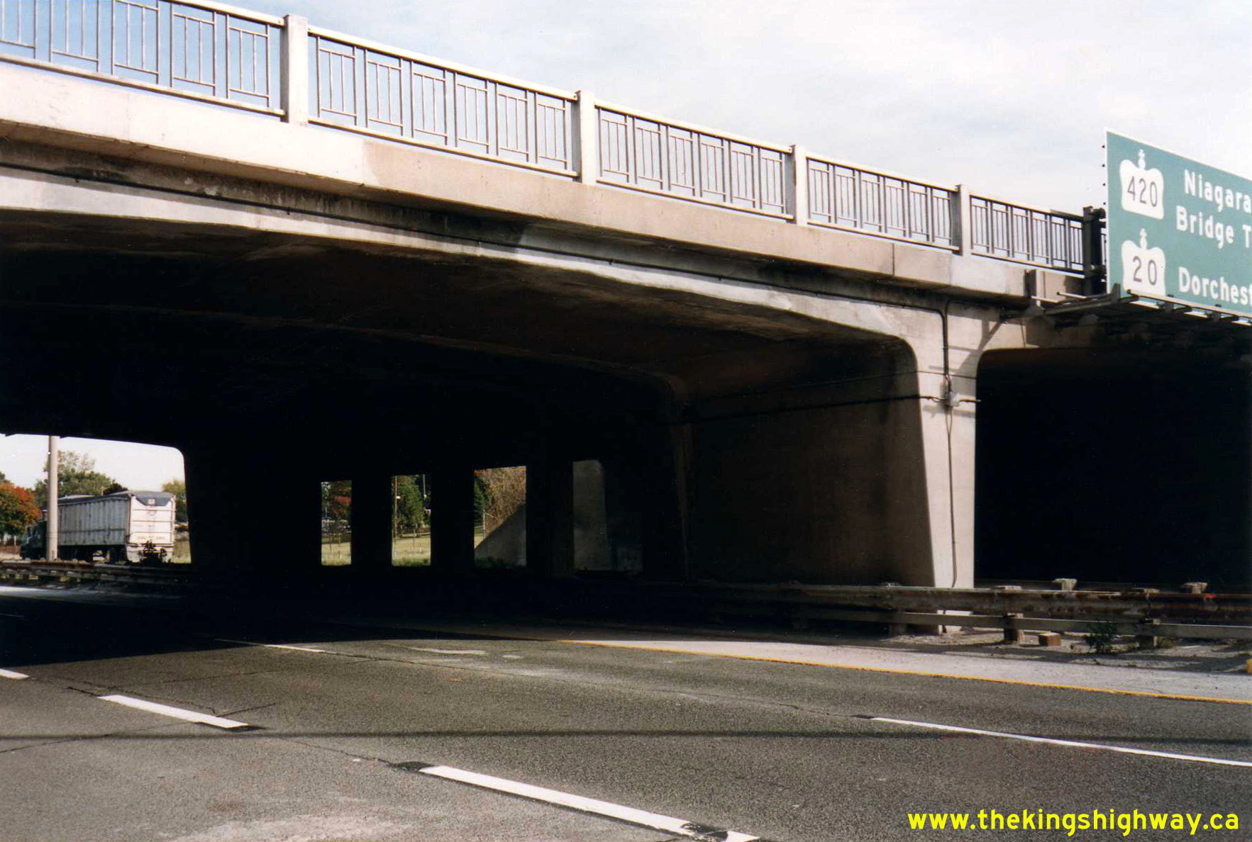
Left - Facing east along Lundy's Lane towards Niagara Falls at the Queen Elizabeth Way Underpass (September 16, 1981) (Photo courtesy of Ontario Ministry of Transportation - © King's Printer for Ontario, 2011) Right - Overhead guide sign for the Hwy 420 and Hwy 20 Interchange on the Queen Elizabeth Way in Niagara Falls (September 16, 1981) (Photo courtesy of Ontario Ministry of Transportation - © King's Printer for Ontario, 2010) 

Left - Facing east along Lundy's Lane towards Niagara Falls at the Queen Elizabeth Way Underpass (May 13, 1983) (Photo courtesy of Ontario Ministry of Transportation - © King's Printer for Ontario, 2011) Right - Facing east along Lundy's Lane towards Niagara Falls at the Queen Elizabeth Way Underpass in 1985. Note the wide paved shoulders across the bridge, which used to carry traffic to and from the QEW cloverleaf ramps. Once the cloverleaf ramps were removed at Lundy's Lane during the early 1970s, the former ramp access lanes were just painted off from the through lanes. (Photo courtesy of Ontario Ministry of Transportation - © King's Printer for Ontario, 2011) 

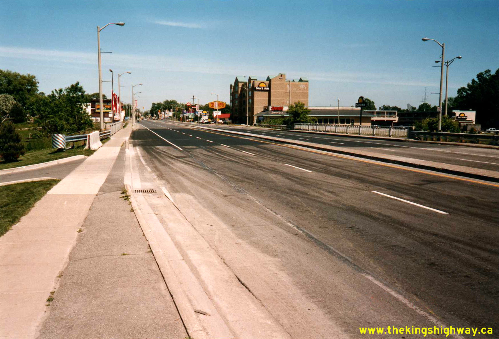
Left - Facing east along Lundy's Lane towards Niagara Falls at the Queen Elizabeth Way Underpass. Note that the fluorescent tube lighting system has
been replaced with a high-pressure sodium (HPS) lighting system. Photo taken on June 18, 1987. (Photo courtesy of Ontario Ministry of Transportation - © King's Printer for Ontario, 2011) Right - Facing west towards Fonthill across the Lundy's Lane Overpass (Site #34-28) on the Queen Elizabeth Way, showing the deck rehabilitation carried out under Contract #1992-93. See an Enlarged Photo Here. Photo taken on June 16, 1993. (Photo courtesy of Ontario Ministry of Transportation - © King's Printer for Ontario, 2011) 

Left - Southern side of the Lundy's Lane Overpass (Site #34-28) on the Queen Elizabeth Way in Niagara Falls. See an
Enlarged Photo Here. Photo taken on October 14, 1993. (Photo courtesy of Ontario Ministry of Transportation - © King's Printer for Ontario, 2011) Right - Close-up of the steel handrail design of the Lundy's Lane Overpass on the Queen Elizabeth Way. The Lundy's Lane Overpass was rehabilitated several years ago, resulting in the replacement of the steel handrail with a concrete parapet. Photo taken on September 26, 1996. (Photo courtesy of Ontario Ministry of Transportation - © King's Printer for Ontario, 2011)
Continue on to King's Highway 20 Photos: Hamilton to Smithville
|
|---|
Links to Adjacent King's Highway Photograph Pages:
Back to King's Highway 19 Photos /
King's Highway 20 History /
On to King's Highway 21 Photos
Ontario Highway History - Main Menu / Back to List of Highways Website contents, photos & text © 2002-2026, Cameron
Bevers (Webmaster) - All Rights Reserved / Contact Me
|
|---|