
| 
|  |
|
|
This page contains present day photos (Year 2000 to date) of Ontario's King's Highway 20, arranged by location from Hamilton
easterly to Smithville. All photographs displayed on this page were taken by the Webmaster (Cameron Bevers), unless specifically noted otherwise. Click on any
thumbnail to see a larger image!
Please note that all photographs displayed on this
website are protected by copyright. These photographs must not be reproduced, published,
electronically stored or copied, distributed, or posted onto other websites without
my written permission. If you want to use photos from this website, please
email me first for permission. Thank-you!
|
|---|
|
Page 2: Present Day King's Highway 20 Photographs (Hamilton to Smithville)

Left - Facing east along the Queen Elizabeth Way towards the Hwy 20 (Centennial Parkway) Interchange in Hamilton from the Red Hill Valley Parkway Overpass. The
exit ramp to Centennial Parkway at lower-left passes below the Red Hill Valley Parkway's on-ramp to the Niagara-bound Queen Elizabeth Way. See
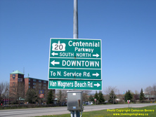
an Enlarged Photo Here. (Photograph taken on November 13, 2007 - © Cameron Bevers) Right - Green guide sign for Hwy 20 (Centennial Parkway) at the Queen Elizabeth Way Interchange in Hamilton. Although the sign indicates that Hwy 20 goes north from here, the highway does actually end at this interchange. Up until the mid-1960s, however, Hwy 20 extended north all the way into Downtown Burlington. See an Enlarged Photo Here. (Photograph taken on May 8, 2005 - © Cameron Bevers) 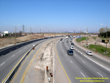
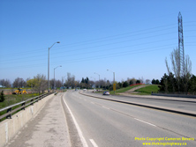
Left - Facing west along the Queen Elizabeth Way from the Hwy 20 (Centennial Parkway) Overpass in Hamilton. When this photo was taken in May 2005, construction
had just commenced on the new Red Hill Valley Parkway Interchange. See an Enlarged Photo Here. (Photograph taken on May 8, 2005 - © Cameron Bevers) Right - Northern terminus of Hwy 20 (Centennial Parkway) at the Queen Elizabeth Way Interchange in Hamilton. Historically, Hwy 20 continued north into Downtown Burlington across the "Beach Strip". With the completion of the Burlington Skyway in 1958, traffic had an alternate route to using Hwy 20 across the Beach Strip between Hamilton and Burlington. Provincial jurisdiction over Hwy 20 north of the Queen Elizabeth Way Interchange ceased in the 1960s, when about 6 miles of Hwy 20 via Van Wagner's Beach Road, Beach Boulevard and Lakeshore Road was transferred over to municipal control. The grade separation for the new flyover ramp to the Red Hill Valley Parkway had not been built yet when this photo was taken in 2005. See an Enlarged Photo Here. (Photograph taken on May 8, 2005 - © Cameron Bevers) 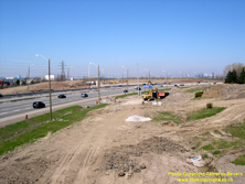

Left - Site of the new flyover ramp from the Toronto-bound Queen Elizabeth Way to the Red Hill Valley Parkway in May 2005, during the initial stages of
construction under Contract #2005-2008. This view is facing west from the Hwy 20 (Centennial Parkway) Interchange in Hamilton. See an
Enlarged Photo Here. (Photograph taken on May 8, 2005 - © Cameron Bevers) Right - View of the northern interchange ramps for Hwy 20 (Centennial Parkway) in May 2005 at the start of construction. This view shows preparatory work required to relocate the north interchange ramps to permit construction of the new flyover ramp to the Red Hill Valley Parkway. The beleaguered Centennial Parkway Interchange has been reconfigured twice since it was first built in the mid-1970s, due to the design challenges of accommodating the proposed Red Hill Valley Parkway Interchange's ramps. Today, the exit ramp to Centennial Parkway curves around the near-side of the hydro tower. See an Enlarged Photo Here. (Photograph taken on May 8, 2005 - © Cameron Bevers) 

Left - Oversized route marker sign marking the entrance ramp to the Queen Elizabeth Way at Hwy 20 (Centennial Parkway) in Hamilton. This is a "positive"
version of the sign, where the sign's "QEW" lettering and crown outline are superimposed on the gold background. See an
Enlarged Photo Here. (Photograph taken on October 6, 2006 - © Cameron Bevers) Right - Conversely, this "negative" version of the Queen Elizabeth Way route marker at the Hwy 20 (Centennial Parkway) Interchange shows the "QEW" lettering cut out from within a solid blue crown. Both versions are in use along the highway, with the "negative" versions being more commonly seen today. See an Enlarged Photo Here. (Photograph taken on October 6, 2006 - © Cameron Bevers) 

Left - Facing east along the Queen Elizabeth Way towards Grimsby from the Hwy 20 (Centennial Parkway) Overpass in 2005. As part of the Red Hill Valley Parkway
Interchange's construction, the Queen Elizabeth Way was expanded from six to eight lanes at Hwy 20. The highway was expanded from four to six lanes previously in 1992,
under Contract #1992-46. Unlike Ontario's other freeways, the Queen Elizabeth Way was unique in that it was originally built in the 1930s as a four-lane divided
highway without any access controls in place. Consequently, adjacent property owners could construct driveways out onto the new highway without any permits. Within a
few years of the highway's completion, enterprising property owners established roadside businesses, fruit stands, motels, gas stations and other amenities for
motorists using the new highway between Hamilton and Niagara Falls. Eventually, the Queen Elizabeth Way became proliferated with private entrances. Motorists using
the highway had to constantly watch out for traffic slowing to turn into these entrances, or worse - slow traffic suddenly entering the highway from the entrances. By
the 1960s, this situation became intolerable and the Department of Highways of Ontario (DHO) took action. The Queen Elizabeth Way was steadily converted into a true
freeway with full access control between Hamilton and St. Catharines during the 1960s and early 1970s, when parallel service roads were built along with
grade-separated crossings at all major roads. See an Enlarged Photo Here. (Photograph taken on May 8, 2005 - © Cameron Bevers) Right - Aerial view of the Queen Elizabeth Way and Hwy 20 (Centennial Parkway) Interchange in 2006, facing west. At the time this photo was taken, the new flyover ramps to the Red Hill Valley Parkway were really beginning to take form. It may see hard to believe, but the Hwy 20 Interchange was originally built in the 1970s as a "Parclo A-4" configuration with sub-collector lanes. Due to design changes with the proposed Red Hill Valley Parkway Interchange in the ensuing years, the old interchange design at Hwy 20 wasn't compatible. The interchange had to be retrofitted to the configuration which is in place today. The first changes to the Hwy 20 Interchange were made in 1992, when the North Service Road was linked directly to Hwy 20 and the north interchange ramps were converted from a "Parclo A-4" configuration to a "buttonhook" configuration. These ramps had to be relocated again in 2005-2006 in order to make way for the Red Hill Valley Parkway Interchange, as seen in this photo. See an Enlarged Photo Here. (Photograph taken on November 3, 2006 - © Cameron Bevers) 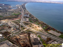

Left - Aerial view of the Queen Elizabeth Way and Hwy 20 (Centennial Parkway) Interchange in 2006, facing northwest towards the Beach Strip. From this vantage
point, it is easy to see why the Beach Strip has formed such a strategic cut-off route for highways over the past century. The Department of Public Highways of
Ontario assumed jurisdiction and control over the highway across the Beach Strip in May 1923. Known originally as Hwy 8A, this cut-off route was later renumbered as
Hwy 20. The cut-off route across the Beach Strip was about 7 miles shorter and considerably faster than the route offered via Hwy 2, Hwy 6 and Hwy 8 through Downtown
Hamilton. The Beach Strip was also earmarked for a high-level canal crossing as early as 1937, but competing construction priorities and shortages of structural steel
caused by World War II delayed construction of the Burlington Skyway until the 1950s. See an
Enlarged Photo Here. (Photograph taken on November 3, 2006 - © Cameron Bevers) Right - Facing north along Hwy 20 (Centennial Parkway) towards the Queen Elizabeth Way in Hamilton in 2006. This aerial photo shows the site of the infamous Stoney Creek Traffic Circle - a large 1930s-era rotary junction that was built at the intersection of the Queen Elizabeth Way and Hwy 20. The Stoney Creek Traffic Circle was replaced with a grade-separated interchange in the mid-1970s under Contract #1974-110. Click here to see a Historical 1970 Aerial Photo of the old Stoney Creek Traffic Circle shortly before it was replaced. See an Enlarged Photo Here. (Photograph taken on November 3, 2006 - © Cameron Bevers) 

Left - Facing west along the Queen Elizabeth Way towards Burlington from the Hwy 20 (Centennial Parkway) Interchange in Hamilton in 2006. The
partially-completed Red Hill Valley Parkway Interchange can be seen in the distance. See an
Enlarged Photo Here. (Photograph taken on October 6, 2006 - © Cameron Bevers) Right - Queen Elizabeth Way facing east towards Grimsby from the Hwy 20 (Centennial Parkway) Interchange in Hamilton in 2006. The new entrance ramp from the Red Hill Valley Parkway to the Niagara-bound Queen Elizabeth Way was completed at the time this photo was taken, but it was in a staged configuration. Only traffic originating from Hwy 20 (Centennial Parkway) was using this on-ramp at the time. See an Enlarged Photo Here. (Photograph taken on October 6, 2006 - © Cameron Bevers) 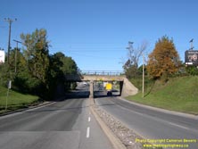

Left - Approaching the Stoney Creek Railway Subway on Hwy 20 (Centennial Parkway) in Hamilton, facing north towards the Queen Elizabeth Way Interchange.
See an Enlarged Photo Here. (Photograph taken on October 6, 2006 - © Cameron Bevers) Right - Southern side of the Stoney Creek Railway Subway on Hwy 20 (Centennial Parkway). This two-span concrete slab structure was completed in 1929. See an Enlarged Photo Here. (Photograph taken on October 6, 2006 - © Cameron Bevers) 

Left - Two 1929 date stamps appear on this side of the Stoney Creek Railway Subway on Hwy 20 (Centennial Parkway). One is centred above the roadway, while the
other is located on the southeast abutment wall. See an Enlarged Photo Here. (Photograph taken on October 6, 2006 - © Cameron Bevers) Right - Close-up of the 1929 date stamp in the southeast abutment wall of the Stoney Creek Railway Subway. See an Enlarged Photo Here. (Photograph taken on October 6, 2006 - © Cameron Bevers) 
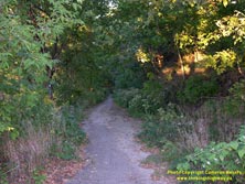
Left - Hwy 20 once followed the Glover Mountain Access up the Niagara Escarpment in Hamilton. This photo shows the long-abandoned highway right-of-way that is
now just used as a walking trail. This was the original alignment for Hwy 20 between 1930 and 1932. See an
Enlarged Photo Here. (Photograph taken on September 19, 2004 - © Cameron Bevers) Right - Abandoned Glover Mountain Road (Old Hwy 20) as seen from the top of the Niagara Escarpment. This original section of Hwy 20 was bypassed by a new alignment on an improved grade in the early 1930s. See an Enlarged Photo Here. (Photograph taken on September 19, 2004 - © Cameron Bevers) 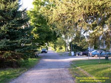

Left - The original alignment of Hwy 20 emerged at Webster Road, at the foot of the Niagara Escarpment. It almost seems hard to believe that this narrow
laneway was once a portion of Hwy 20. See an Enlarged Photo Here. (Photograph taken on September 19, 2004 - © Cameron Bevers) Right - Western side of the Stoney Creek Railway Overhead on Hwy 20. This three-span concrete "T" girder structure was completed in 1931, as part of the diversion to bypass the old Glover Mountain Access route. See an Enlarged Photo Here. (Photograph taken on September 19, 2004 - © Cameron Bevers) 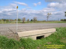
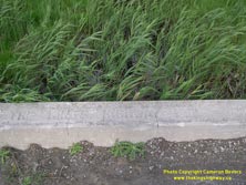
Left - Old culvert from the 1930s on Hwy 20 between Elfrida and Smithville (Photograph taken on October 18, 2005 - © Cameron Bevers) Right - Inscription on a culvert on Hwy 20 between Elfrida and Smithville - "THE KING'S HIGHWAY 1931" (Photograph taken on October 18, 2005 - © Cameron Bevers) 
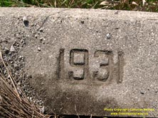
Left - A former alignment of Hwy 20 west of Smithville (Photograph taken on October 18, 2005 - © Cameron Bevers) Right - Date stamp (1931) on a concrete culvert near Smithville (Photograph taken on October 18, 2005 - © Cameron Bevers) 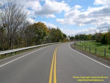
Above - Facing east along Hwy 20 towards Smithville (Photograph taken on October 18, 2005 - © Cameron Bevers)
Continue on to King's Highway 20 Photos: Smithville to Niagara Falls
|
|---|
Links to Adjacent King's Highway Photograph Pages:
Back to Hwy 20 - Historical Photos (1930-1999)
Hwy 20 Photo Index
On to Hwy 20 - Smithville to Niagara Falls
Back to King's Highway 19 Photos /
King's Highway 20 History /
Back to King's Highway 21 Photos
Ontario Highway History - Main Menu / Back to List of Highways Website contents, photos & text © 2002-2025, Cameron
Bevers (Webmaster) - All Rights Reserved / Contact Me |
|---|