
| 
| |
|
|
This page contains historical and present day photos of Ontario's King's Highway 3B (Windsor Business Route), along with its
predecessor route, King's Highway 3A (Windsor). All photographs displayed on this page were taken by the Webmaster (Cameron Bevers), unless specifically noted
otherwise. Historical photographs are arranged in approximate chronological order, while present day photographs (2010 to date) are arranged by location from
south to north. Click on any thumbnail to see a larger image!
Please note that all photographs displayed on this
website are protected by copyright. These photographs must not be reproduced, published,
electronically stored or copied, distributed, or posted onto other websites without
my written permission. If you want to use photos from this website, please
email me first for permission. Thank-you!
|
|---|
|
Historical King's Highway 3B (Windsor) Photographs
  Above - Circa 1930 postcard view of the interior of the new Detroit-Windsor Tunnel constructed below the Detroit River. This engineering marvel was among the
earliest submarine highway tunnels ever built in North America. It was also the first of such tunnels constructed anywhere in the world which also crossed an
international boundary line. The new one-mile highway tunnel was built at a cost of $23 Million in 1930 Dollars, the equivalent of $411 Million in 2025 Dollars. The
tunnel officially opened to traffic on November 1, 1930, after about 2 1/2 years of construction. This interesting promotional postcard was produced in the early
1930s, which advertised commute times from Detroit to Windsor in just 4 minutes via "The Fleetway". Previously, motor vehicle traffic wishing to travel directly
between the two downtown areas had to traverse the Detroit River via a ferry service. See an
Enlarged Photo Here. Photo taken circa 1930. Above - Circa 1930 postcard view of the interior of the new Detroit-Windsor Tunnel constructed below the Detroit River. This engineering marvel was among the
earliest submarine highway tunnels ever built in North America. It was also the first of such tunnels constructed anywhere in the world which also crossed an
international boundary line. The new one-mile highway tunnel was built at a cost of $23 Million in 1930 Dollars, the equivalent of $411 Million in 2025 Dollars. The
tunnel officially opened to traffic on November 1, 1930, after about 2 1/2 years of construction. This interesting promotional postcard was produced in the early
1930s, which advertised commute times from Detroit to Windsor in just 4 minutes via "The Fleetway". Previously, motor vehicle traffic wishing to travel directly
between the two downtown areas had to traverse the Detroit River via a ferry service. See an
Enlarged Photo Here. Photo taken circa 1930.(Photo courtesy of The Process Photo Studios, Chicago) 
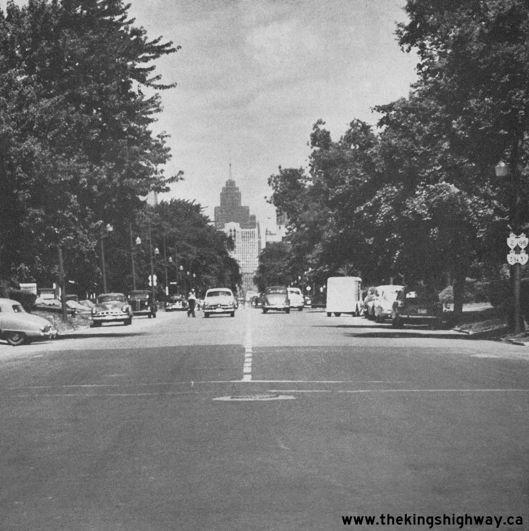
Above - Facing north along Ouellette Avenue towards Downtown Windsor in 1951. Note the signpost at right, which bears no fewer than four King's Highway shields.
Although the route numbers are difficult to discern in this photo, the four marked routes are Hwy 2, Hwy 3B, Hwy 39 and Hwy 98. For a number of years, all four of
these King's Highways were signed concurrently along Ouellette Avenue into Downtown Windsor. However, due to the construction of the E.C. Row Expressway and the
decommissioning of Hwy 39 and Hwy 98, three of these highway routes were eventually removed from Ouellette Avenue. Only the Hwy 3B route designation survived until
the 1990s. See an Enlarged Photo Here. Photo taken on July 10, 1951. (Photo courtesy of Ontario Ministry of Transportation - © King's Printer for Ontario, 1951) 
Above - Postcard view of Ouellette Avenue (Hwy 3B) in Downtown Windsor in 1953, facing north from Park Street. See an
Enlarged Photo Here. (Photo courtesy of Sigal Brothers Publishing, Windsor) 
 Above Photos - Circa 1954 postcard views of a passenger car and a tunnel bus crossing the international boundary line between the United States and Canada
within the Detroit-Windsor Tunnel. Interestingly, there were actually two versions of this postcard produced. The photo used for the initial postcard issue in the
mid-1950s can be seen at left. The postcard at left was mailed from Windsor to Chicago, with a postmarked date of May 30, 1958. However, it is believed that the
original photo was taken even earlier than 1958, as the car has an Ontario license plate whose style is consistent with the 1954 license plate issue. Later versions
of this postcard sold up until the 1970s show the updated Canadian and United States flags at the boundary line within the tunnel, which were carefully overlaid by
the publisher on top of the original photograph and then reprinted. The United States changed to the current 50-star flag in 1960, after Alaska and Hawaii were
granted statehood in 1959. Canada retired its variant of the Union Jack and replaced it with the new maple leaf flag in 1965. The newer version of the postcard at
right was addressed to a recipient in France, and bore the date September 5, 1971. Some of the photos you see on this website have quite literally been around the
world! See an Enlarged Photo Here (Left) and
Enlarged Photo Here (Right). Photos taken circa 1954. Above Photos - Circa 1954 postcard views of a passenger car and a tunnel bus crossing the international boundary line between the United States and Canada
within the Detroit-Windsor Tunnel. Interestingly, there were actually two versions of this postcard produced. The photo used for the initial postcard issue in the
mid-1950s can be seen at left. The postcard at left was mailed from Windsor to Chicago, with a postmarked date of May 30, 1958. However, it is believed that the
original photo was taken even earlier than 1958, as the car has an Ontario license plate whose style is consistent with the 1954 license plate issue. Later versions
of this postcard sold up until the 1970s show the updated Canadian and United States flags at the boundary line within the tunnel, which were carefully overlaid by
the publisher on top of the original photograph and then reprinted. The United States changed to the current 50-star flag in 1960, after Alaska and Hawaii were
granted statehood in 1959. Canada retired its variant of the Union Jack and replaced it with the new maple leaf flag in 1965. The newer version of the postcard at
right was addressed to a recipient in France, and bore the date September 5, 1971. Some of the photos you see on this website have quite literally been around the
world! See an Enlarged Photo Here (Left) and
Enlarged Photo Here (Right). Photos taken circa 1954.(Photo courtesy of Sigal Brothers Publishing, Windsor) 
Above - Aerial view of the Hwy 401 "Tunnel Route", facing east from the Howard Avenue (Hwy 3B) Interchange in Windsor. The new Windsor Approach legs of Hwy 401
were officially opened to traffic on June 9, 1958. These two new routes filtered Hwy 401 traffic arriving in Windsor onto the appropriate highways bound for the
Ambassador Bridge (via Hwy 3) and the Detroit-Windsor Tunnel (via Hwy 3B). See an
Enlarged Photo Here. Photo taken on September 17, 1958. (Photo courtesy of Ontario Ministry of Transportation - © King's Printer for Ontario, 1958) 
Above - Aerial view of the Windsor High-Speed Interchange at the diverge between the Hwy 401 Tunnel and Bridge Routes in 1958. The Hwy 401 Bridge Route exited
left to join Hwy 3 (Huron Church Road) to the Ambassador Bridge, while the Hwy 401 Tunnel Route exited right to join Hwy 3B to the Detroit-Windsor Tunnel. See an
Enlarged Photo Here. Photo taken on September 17, 1958. (Photo courtesy of Ontario Ministry of Transportation - © King's Printer for Ontario, 1958) 
Above - Facing west towards the Windsor High-Speed Interchange on Hwy 401 from the Walker Road Underpass in Windsor. See an
Enlarged Photo Here. Photo taken on September 23, 1958. (Photo courtesy of Ontario Ministry of Transportation - © King's Printer for Ontario, 1958)  Above - Jackson Park Canadian Pacific Railway (CPR) Overhead under construction on Hwy 3B, Contract #1961-01. See an
Enlarged Photo Here. Photo taken in 1962. Above - Jackson Park Canadian Pacific Railway (CPR) Overhead under construction on Hwy 3B, Contract #1961-01. See an
Enlarged Photo Here. Photo taken in 1962.(Photo courtesy of Ontario Ministry of Transportation - © King's Printer for Ontario, 1962)  Above - Jackson Park CPR Overhead under construction on Ouellette Avenue (Hwy 3B) in Windsor. Under Contract #1961-01, a new railway overhead was constructed on
an extension of Ouellette Avenue from Tecumseh Road southerly to Dougall Avenue. This realignment of Hwy 3B bypassed a busy at-grade railway crossing on the old route
of Hwy 3B via Dougall Avenue, along with an awkward jog in the old route of Hwy 3B between Dougall Avenue and Ouellette Avenue via Tecumseh Road. The Ouellette Avenue
Extension greatly improved traffic flow on the southern approach to Windsor's City Centre. See an
Enlarged Photo Here. Photo taken in 1962. Above - Jackson Park CPR Overhead under construction on Ouellette Avenue (Hwy 3B) in Windsor. Under Contract #1961-01, a new railway overhead was constructed on
an extension of Ouellette Avenue from Tecumseh Road southerly to Dougall Avenue. This realignment of Hwy 3B bypassed a busy at-grade railway crossing on the old route
of Hwy 3B via Dougall Avenue, along with an awkward jog in the old route of Hwy 3B between Dougall Avenue and Ouellette Avenue via Tecumseh Road. The Ouellette Avenue
Extension greatly improved traffic flow on the southern approach to Windsor's City Centre. See an
Enlarged Photo Here. Photo taken in 1962.(Photo courtesy of Ontario Ministry of Transportation - © King's Printer for Ontario, 1962) 
Above - Grading for the new Hwy 3B (Dougall Avenue) Interchange on the E.C. Row Expressway in Windsor, Contract #1970-88. See an
Enlarged Photo Here. Photo taken in 1971. (Photo courtesy of Ontario Ministry of Transportation - © King's Printer for Ontario, 1971) 
Above - Sign assembly marking the end of Hwy 401's Tunnel Route and the start of Hwy 3B on Dougall Avenue near Darcey Street in Windsor. See an
Enlarged Photo Here. (Photograph taken on April 19, 1997 - © Roger Fox) 
 Left - Facing east along Dougall Parkway from the Howard Avenue Overpass in Windsor. This short section of freeway was once part of Hwy 401's "Tunnel Route",
which connected Dougall Avenue (Hwy 3B) to the main route of Hwy 401 about 3 km to the east. Jurisdiction over a 2 km section of this short freeway was transferred
from the province to the City of Windsor, effective January 1, 1998. Provincial jurisdiction over the highway now begins just east of the 6th Concession Overpass. See
an Enlarged Photo Here. Left - Facing east along Dougall Parkway from the Howard Avenue Overpass in Windsor. This short section of freeway was once part of Hwy 401's "Tunnel Route",
which connected Dougall Avenue (Hwy 3B) to the main route of Hwy 401 about 3 km to the east. Jurisdiction over a 2 km section of this short freeway was transferred
from the province to the City of Windsor, effective January 1, 1998. Provincial jurisdiction over the highway now begins just east of the 6th Concession Overpass. See
an Enlarged Photo Here.(Photograph taken on December 5, 2004 - © Cameron Bevers) Right - View of the end of Hwy 401's Tunnel Route (today's Dougall Parkway) from the Howard Avenue Overpass, facing west. At this interchange, Hwy 401 curved
to the right, where it merged into Dougall Avenue (Hwy 3B). Traffic could continue north from this interchange into Windsor via Hwy 3B. The official western terminus
of Hwy 401's Tunnel Route was in the vicinity of Darcey Street, an intersection located just west of the Howard Avenue Interchange. See an
Enlarged Photo Here.(Photograph taken on December 5, 2004 - © Cameron Bevers) 

Left - Eastern side of the Jackson Park Railway Overhead (MTO Site #6-5) on Hwy 3B in Windsor. This 11-span continuous concrete slab structure was completed in
1962. See an Enlarged Photo Here. (Photograph taken on August 4, 2007 - © Cameron Bevers) Right - View underneath the Jackson Park Railway Overhead on Hwy 3B in Windsor. This massive structure was built under Contract #1961-01 as part of the Ouellette Avenue Extension in the early 1960s. The construction of this grade separation was an important step in providing a direct connection for Hwy 3B between Ouellette Avenue and Dougall Avenue. The new highway and overhead bridge also bypassed a busy at-grade railway crossing with multiple tracks on the old route of Hwy 3B. See an Enlarged Photo Here. (Photograph taken on August 4, 2007 - © Cameron Bevers) 

Left - Dougall Avenue Subway (MTO Site #6-282) on Hwy 3B in Windsor. This two-span steel plate girder structure was completed in 1930. See an
Enlarged Photo Here. (Photograph taken on August 4, 2007 - © Cameron Bevers) Right - Facing south along Hwy 3B towards the Dougall Avenue Subway in Windsor. See an Enlarged Photo Here. (Photograph taken on August 4, 2007 - © Cameron Bevers) 

Left - Facing north along Hwy 3B towards the Dougall Avenue Subway in Windsor. See an
Enlarged Photo Here. (Photograph taken on August 4, 2007 - © Cameron Bevers) Right - Date stamp (1930) on the Dougall Avenue Subway on Hwy 3B in Windsor. See an Enlarged Photo Here. (Photograph taken on August 4, 2007 - © Cameron Bevers) 
 Left - Aerial view of the Howard Avenue Interchange on Hwy 401's Tunnel Route (today's Dougall Parkway) at the junction with Hwy 3B, facing northeast.
Historically, the route of Hwy 3B exited from Dougall Avenue here and headed south via Howard Avenue at lower right to connect with Hwy 3 at Huron Church Road.
Motorists on Hwy 3B headed for London or Toronto could simply pass through this interchange along the divided highway in order to reach Hwy 401. See an
Enlarged Photo Here. Left - Aerial view of the Howard Avenue Interchange on Hwy 401's Tunnel Route (today's Dougall Parkway) at the junction with Hwy 3B, facing northeast.
Historically, the route of Hwy 3B exited from Dougall Avenue here and headed south via Howard Avenue at lower right to connect with Hwy 3 at Huron Church Road.
Motorists on Hwy 3B headed for London or Toronto could simply pass through this interchange along the divided highway in order to reach Hwy 401. See an
Enlarged Photo Here.(Photograph taken on August 4, 2007 - © Cameron Bevers) Right - Aerial view of the Howard Avenue Interchange on Hwy 401's Tunnel Route, facing south. This interchange was built in the mid-1950s under Contract
#1955-133 (structure), Contract #1955-213 (grading) and Contract #1956-207 (concrete paving). The Windsor Entrance Interchanges were officially opened to traffic on
June 9, 1958. This interchange allowed through traffic bound for Hwy 401 to pass seamlessly below Hwy 3B (Howard Avenue). See an
Enlarged Photo Here.(Photograph taken on August 4, 2007 - © Cameron Bevers)  Above - Aerial view of the Howard Avenue Interchange on Hwy 401's Tunnel Route, facing east. Compare this 2007 photo to this
Historical 1958 Photo, which shows the same view of the interchange shortly after
completion in the 1950s. Although the interchange itself has not changed at all, the city has since developed along both sides of the highway. See an
Enlarged Photo Here. Above - Aerial view of the Howard Avenue Interchange on Hwy 401's Tunnel Route, facing east. Compare this 2007 photo to this
Historical 1958 Photo, which shows the same view of the interchange shortly after
completion in the 1950s. Although the interchange itself has not changed at all, the city has since developed along both sides of the highway. See an
Enlarged Photo Here.(Photograph taken on August 4, 2007 - © Cameron Bevers)
More King's Highway 3B Photographs Coming Soon!
|
|---|
Links to Adjacent King's Highway Photograph Pages:
Back to King's Highway 3 Photos /
King's Highway 3B (Windsor) History /
On to King's Highway 4 Photos
Ontario Highway History - Main Menu / Back to List of Highways Website contents, photos & text © 2002-2026, Cameron
Bevers (Webmaster) - All Rights Reserved / Contact Me
|
|---|