
| 
| |
|
|
This page contains historical photos of Ontario's King's Highway 400 dating from 1946 to 1959. All photographs displayed on
this page were taken by the Ontario Ministry of Transportation, unless specifically noted otherwise. Historical photographs are arranged in approximate chronological
order. Click on any thumbnail to see a larger image!
Please note that all photographs displayed on this
website are protected by copyright. These photographs must not be reproduced, published,
electronically stored or copied, distributed, or posted onto other websites without
my written permission. If you want to use photos from this website, please
email me first for permission. Thank-you!
|
|---|
|
Page 1: Historical King's Highway 400 Photographs (1946 to 1959)

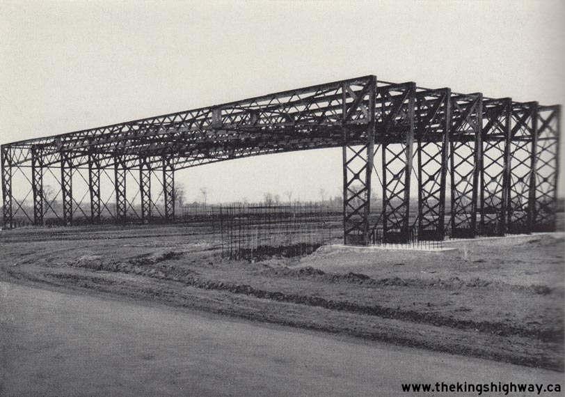
Left - Looking through the new Hwy 27 (Essa Road) underpass on Hwy 400 in Barrie. Photo taken on September 19, 1949. (Photo courtesy of Ontario Ministry of Transportation - © King's Printer for Ontario, 1949) Right - Steel bridge frame construction at Maple Sideroad (now Major Mackenzie Drive) on the Toronto-Barrie Highway. Photo taken on November 17, 1949. (Photo courtesy of Ontario Ministry of Transportation - © King's Printer for Ontario, 1949) 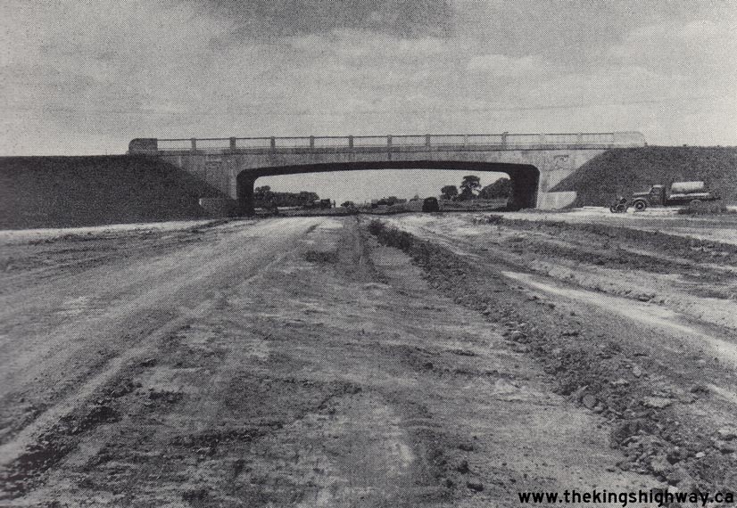
Above - Toronto-Barrie Highway under construction in 1950, showing the new Hwy 7 overpass near Woodbridge. Photo taken on August 8, 1950. (Photo courtesy of Ontario Ministry of Transportation - © King's Printer for Ontario, 1950) 
Above - Concrete pavement construction on the new Toronto-Barrie Highway south of Richvale Sideroad (today's Rutherford Road) near Woodbridge. Photo taken on
July 23, 1951. See an Enlarged Photo Here. (Photo courtesy of Ontario Ministry of Transportation - © King's Printer for Ontario, 1951) 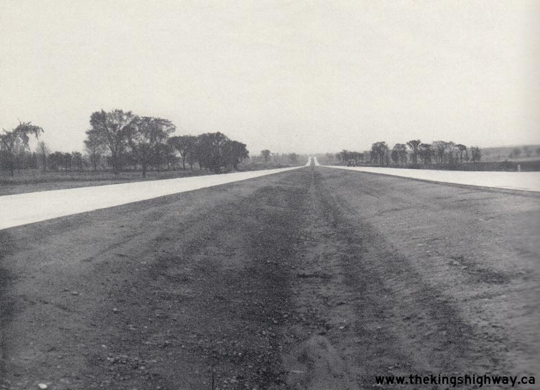
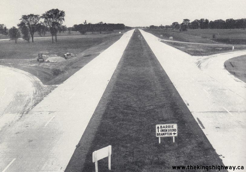
Left - New Hwy 400 looking south from Finch Avenue in Toronto. Photo taken on October 11, 1951. (Photo courtesy of Ontario Ministry of Transportation - © King's Printer for Ontario, 1951) Right - View of Hwy 400 from the Hwy 7 Overpass, looking north towards Barrie. Photo taken on October 11, 1951. (Photo courtesy of Ontario Ministry of Transportation - © King's Printer for Ontario, 1951) 
Above - Zone painting on the new Hwy 400 at the Hwy 7 Cloverleaf, taken shortly after Hwy 400 was officially opened to traffic. Photo taken on July 4, 1952.
See an Enlarged Photo Here. (Photo courtesy of Ontario Ministry of Transportation - © King's Printer for Ontario, 1952) 
Above - Aerial View of the Hwy 400 & Hwy 401 Cloverleaf in Toronto, looking southeast. Photo taken on October 1, 1953. See an
Enlarged Photo Here. (Photo © Archives of Ontario - Series RG-14-162-2, Box B986, Photo #648-10) This cloverleaf formed the junction of Hwy 400 and Hwy 401 for almost 15 years. The interchange was completely redesigned in the mid-1960s in response to the widening of Hwy 401 and the extension of Hwy 400 south to Jane Street. Compare the 1953 aerial photo above to this 2004 aerial photo which I took of the current semi-directional three-level interchange from the same angle (facing southeast). 
Above - Hwy 400 & Hwy 7 Interchange looking northeast towards Maple. Photo taken on October 1, 1953. See an
Enlarged Photo Here. The present-day site of the Hwy 400 & Hwy 407 ETR Interchange is
situated in the bottom-right corner of this photo, while Weston Road can be seen approaching its intersection with Hwy 7 at left. Compare the 1953 aerial photo of the
Hwy 400 & Hwy 7 Interchange in Vaughan shown above with this 2004 aerial photo, which I
took to show the unfortunate urban sprawl that has taken place over the past 25 years in this part of York Region. Nearly all of the vacant land seen in the 1953
photo above has become urbanized. (Photo © Archives of Ontario - Series RG-14-162-2, Box B986, Photo #650-15) 

Left - Looking north along Hwy 400 from the Wilson Avenue Underpass in Toronto. Photo taken on October 29, 1953. See an
Enlarged Photo Here. (Photo © Archives of Ontario - Series RG-14-162-5-163, Box B986, Photo #575) Right - Hwy 400 facing north approaching the Hwy 88 Cloverleaf near Bradford (November 5, 1953). (Photo © Archives of Ontario - Series RG-14-162-5-163, Box B986, Photo #607) 
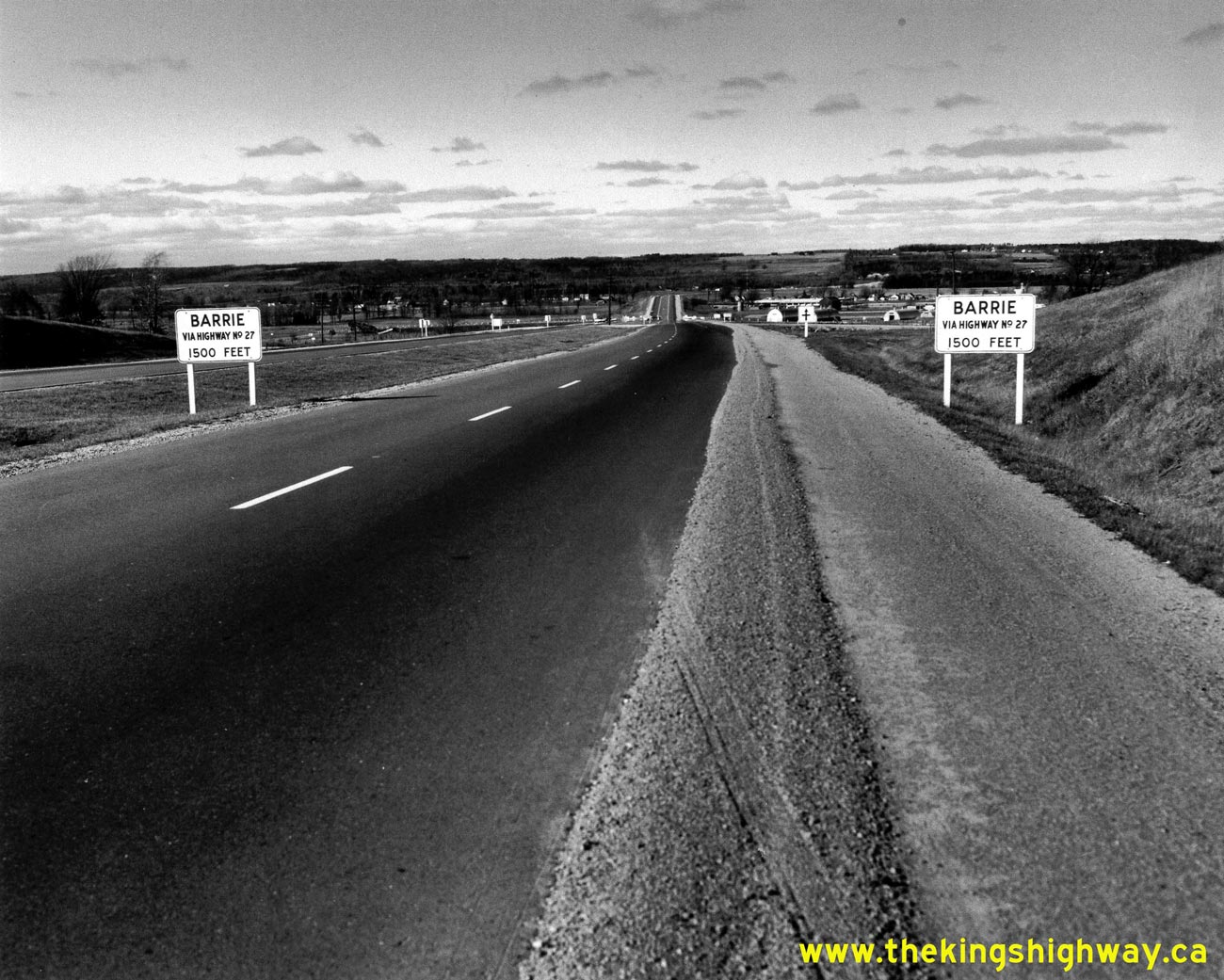
Above - Hwy 400 facing north approaching the Hwy 27 (Essa Road) Interchange in Barrie. Note the at-grade intersection at Innisfil Township Line 14 (today's
Little Avenue in Barrie) which once crossed Hwy 400 just south of the Hwy 27 Interchange. Although Hwy 400 was originally constructed with grade separations and
cloverleaf interchanges at the more heavily-trafficked crossing roads, several low-volume crossing roads along Hwy 400 between Toronto and Barrie had to be left as
at-grade intersections for several years due to shortages of structural steel and other construction materials following World War II. See an
Enlarged Photo Here. Photo taken on November 5, 1953. (Photo © Archives of Ontario - Series RG-14-162-5-163, Box B986, Photo #609) 
Above - Aerial view of the Hwy 400 and King Side Road Interchange in 1953. Shortly after this photo was taken, a service centre was constructed
within the loop ramp in the foreground. This service centre was removed in the 1970s, and replaced by an MTO carpool parking lot. The King Road Service
Centre was actually the second service facility opened along Hwy 400. Ontario's very first highway service centre was opened in 1954 at Hwy 400 and
Cookstown Road (today's Hwy 89). See an Enlarged Photo Here. (Photo courtesy of Ontario Ministry of Transportation - © King's Printer for Ontario, 1953) 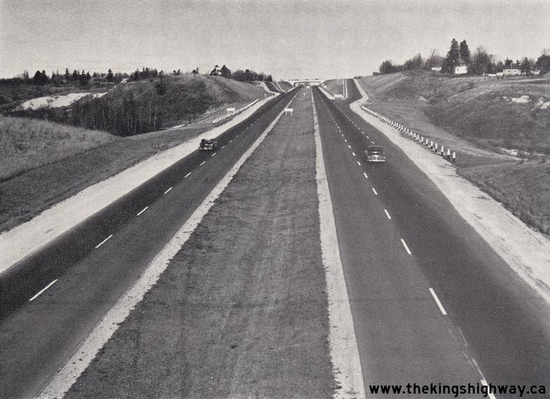
Above - Looking north along Hwy 400 approaching the Hwy 26 & Hwy 27 (Bayfield Street) Interchange in Barrie. Photo taken on November 5, 1953. (Photo courtesy of Ontario Ministry of Transportation - © King's Printer for Ontario, 1953) 
Above - Hwy 400 in 1953, looking north towards Holland Marsh from the King Township Sideroad 35 Overpass (now Hwy 9). Photo taken on November 5, 1953. See an
Enlarged Photo Here. (Photo courtesy of Ontario Ministry of Transportation - © King's Printer for Ontario, 1954) 
Above - Aerial view of the Hwy 26 & Hwy 27 (Bayfield Street) Interchange on Hwy 400 in Barrie, facing south. Photo taken on July 9, 1954. (Photo courtesy of Ontario Ministry of Transportation - © King's Printer for Ontario, 1954) 
Above - Hwy 401 approaching the Hwy 400 Cloverleaf in Toronto, looking east. Photo taken on October 7, 1954. See an
Enlarged Photo Here. (Photo © Archives of Ontario - Series RG-14-151-5-15, Box B1103, Photo #414) 
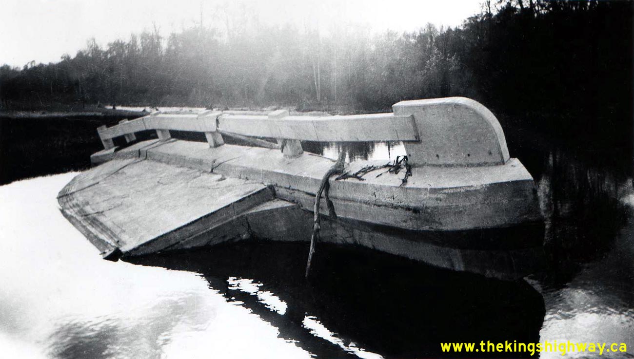
Above - Willow Creek Bridge on Hwy 400 between Barrie and Crown Hill, four days after being destroyed by Hurricane Hazel. On October 15, 1954, Hurricane Hazel
slammed Ontario with unprecedented rainfall and high winds. Rain accumulated so quickly that bridges and culverts on many highways were overwhelmed. Bridge footings
were scoured out by the furious water, resulting in several bridge failures across Ontario's highway system. The original Willow Creek Bridge seen here was a 40-foot
single span concrete rigid frame structure, which was built in 1950 as part of the new Barrie Bypass. The normally lazy Willow Creek became a raging torrent of water
in the hours after Hurricane Hazel's arrival. The storm waters tore a 100-foot wide swath through the highway and dramatically undermined the bridge structure. The
western side of the bridge can be seen leaning precariously into the water, while the eastern end of the structure lies submerged. The destroyed Willow
Creek Bridge was quickly replaced with a three-span steel beam structure with a total length of 132 feet. The replacement structure can be seen in this
1957 Photo. Photo taken on October 19, 1954. See an
Enlarged Photo Here. (Photo courtesy of Ontario Ministry of Transportation - © King's Printer for Ontario, 2014) 

Left - Another view of the partially submerged Willow Creek Bridge on Hwy 400 north of Barrie, shortly after being destroyed by Hurricane Hazel. Photo taken on
October 19, 1954. See an Enlarged Photo Here. (Photo courtesy of Ontario Ministry of Transportation - © King's Printer for Ontario, 2014) Right - Temporary Bailey Bridge installation on Hwy 400 at Willow Creek. When Hurricane Hazel swept across Ontario on October 15-16, 1954, it left behind a trail of damaged or destroyed bridges on both provincial highways and municipal roads. The Department of Highways' supply of temporary Bailey Bridges was quickly taxed as a result of the storm damage. Accordingly, bridge engineers decided that only one Bailey Bridge would be installed on Hwy 400 at Willow Creek, so that the Department's dwindling supply of Bailey Bridges could be used to restore traffic on other damaged highways. As a result, Hwy 400 was reduced to a single lane in each direction for almost a year until the replacement structure at Willow Creek was completed. Photo taken on November 15, 1954. See an Enlarged Photo Here. (Photo courtesy of Ontario Ministry of Transportation - © King's Printer for Ontario, 2014) 

Left - A temporary Bailey Bridge spans the deep channel scoured out by the raging flood waters at Willow Creek. Although the Bailey Bridge was installed on
the northbound (eastern) side of the highway, the temporary bridge carried two-way traffic. The original Hwy 400 structure that was destroyed during Hurricane Hazel
had been mostly dismantled at the time this photo was taken. Only parts of the old bridge's wing walls and deck can be seen poking up from the water. This photo was taken
from the north bank of Willow Creek, facing south towards Barrie. Photo taken on November 15, 1954. See an
Enlarged Photo Here. (Photo courtesy of Ontario Ministry of Transportation - © King's Printer for Ontario, 2014) Right - Temporary Bailey Bridge at Willow Creek on Hwy 400, facing north towards Crown Hill. In what was a sign of the times, note the construction crew working in the water at left, desperately trying to salvage steel reinforcing bars from the ruins of the old Hwy 400 structure. Severe shortages of structural steel gripped the world in the years following both the Second World War and the Korean War, making steel a very precious commodity. Photo taken on November 15, 1954. See an Enlarged Photo Here. (Photo courtesy of Ontario Ministry of Transportation - © King's Printer for Ontario, 2014) 

Left - The replacement bridge on Hwy 400 at Willow Creek was nearing completion at the time this photo was taken in September, 1955. Hot mix asphalt was being
laid on the southbound side of the new bridge. The northbound side of the bridge had already been completed. Photo taken on September 1, 1955. See an
Enlarged Photo Here. (Photo courtesy of Ontario Ministry of Transportation - © King's Printer for Ontario, 2014) Right - New Willow Creek Bridge on Hwy 400, facing north towards Crown Hill in 1955. The northbound side of the bridge had already been completed at the time this photo was taken, although the southbound side was only nearing completion. It may be interesting to note that in the background of this photo, construction work had not yet begun on the future Hwy 400 Extension Interchange at Crown Hill. Photo taken on September 1, 1955. See an Enlarged Photo Here. (Photo courtesy of Ontario Ministry of Transportation - © King's Printer for Ontario, 2014) 
Above - Construction of the new Willow Creek Bridge on Hwy 400 between Barrie and Crown Hill in 1955. The replacement bridge at Willow Creek was a three-span
steel girder structure. The new bridge was more than three times the length of the original concrete rigid frame structure that had been built here in 1950. The
ill-fated original Hwy 400 structure was destroyed during Hurricane Hazel, only four years after it was built. Photo taken on September 1, 1955. See an
Enlarged Photo Here. (Photo courtesy of Ontario Ministry of Transportation - © King's Printer for Ontario, 2014) 
Above - Postcard view of the Hwy 400 and Hwy 27 (Essa Road) Interchange in Barrie (ca. 1955). (Photo courtesy of Alex Wilson Publishing Ltd.) 
Above - Ontario Coat-of-Arms stamp on the Coulson Road Overpass (West Gwillimbury Line 11) on Hwy 400 south of Cookstown. This artistic embellishment was
incorporated into many of Ontario's early freeway structures built in the 1940s and 1950s. Photo taken on January 13, 1956. See an
Enlarged Photo Here. (Photo courtesy of Ontario Ministry of Transportation - © King's Printer for Ontario, 2013) 

Left - Ontario Coat-of-Arms stamp on the Bayfield Street Overpass (Hwy 26 & Hwy 27) on Hwy 400 in Barrie. Note the unusual median-mounted guide sign at right, reading "Hwy 26 & Hwy 27 Points West". Photo taken on January 24, 1956. See an
Enlarged Photo Here. (Photo courtesy of Ontario Ministry of Transportation - © King's Printer for Ontario, 2013) Right - Eastern side of the Willow Creek Bridge on Hwy 400 between Barrie and Crown Hill. Photo taken on August 21, 1957. See an Enlarged Photo Here. (Photo courtesy of Ontario Ministry of Transportation - © King's Printer for Ontario, 2013) 
Above - Willow Creek Bridge on Hwy 400 between Barrie and Crown Hill, facing east (August 21, 1957). (Photo courtesy of Ontario Ministry of Transportation - © King's Printer for Ontario, 2013) 
Above - Grading for the Hwy 400 Extension north of Barrie (1959). (Photo courtesy of Ontario Ministry of Transportation - © King's Printer for Ontario, 1959) 
Above - Roadside diversion and overpass construction at the junction of Hwy 400 and the future Hwy 400 Extension between Barrie and Crown Hill, Contract
#1958-648. Roadside diversions such as this were commonly-used along Ontario's early freeways during the construction of cast-in-place concrete bridges over existing
routes. In many instances, it was more economical to construct a roadside diversion than it was to try and accommodate traffic directly through the bridge
construction site. See an Enlarged Photo Here. (Photo courtesy of Ontario Ministry of Transportation - © King's Printer for Ontario, 1959) 
Above - Completed grading approaching the future Crown Hill Overpass near Barrie in 1959, Contract #1959-46. This view of the future interchange at Hwy 400
and the Hwy 400 Extension is facing southeast towards Barrie. See an Enlarged Photo Here. (Photo courtesy of Ontario Ministry of Transportation - © King's Printer for Ontario, 1959) 
Above - View of Georgian Bay (Tug Channel) from the new causeway on the Port Severn Bypass (Hwy 103, later known as Hwy 69 & Hwy 400). See an
Enlarged Photo Here. Photo taken on August 25, 1959. (Photo courtesy of Ontario Ministry of Transportation - © King's Printer for Ontario, 1959)
Continue on to King's Highway 400 Historical Photos: 1960-1964
|
|---|
Links to Adjacent King's Highway Photograph Pages:
Back to King's Highway 169 Photos /
King's Highway 400 History /
On to King's Highway 401 Photos
Ontario Highway History - Main Menu / Back to List of Highways Website contents, photos & text © 2002-2026, Cameron
Bevers (Webmaster) - All Rights Reserved / Contact Me
|
|---|