
| 
| |
|
|
This page contains present day photos (Year 2000 to date) of Ontario's King's Highway 400, arranged by location from the
Highway 400A & Highway 11 Interchange at Crown Hill northerly to Port Severn. All photographs displayed on this page were taken by the Webmaster
(Cameron Bevers), unless specifically noted otherwise. Click on any thumbnail to see a larger image!
Please note that all photographs displayed on this
website are protected by copyright. These photographs must not be reproduced, published,
electronically stored or copied, distributed, or posted onto other websites without
my written permission. If you want to use photos from this website, please
email me first for permission. Thank-you!
|
|---|
|
Page 15: Present Day King's Highway 400 Photographs (Crown Hill to Port Severn)

Above - Facing south along Hwy 400 towards Barrie from the Partridge Road Overpass. See an
Enlarged Photo Here. (Photograph taken on June 19, 2013 - © Cameron Bevers) 

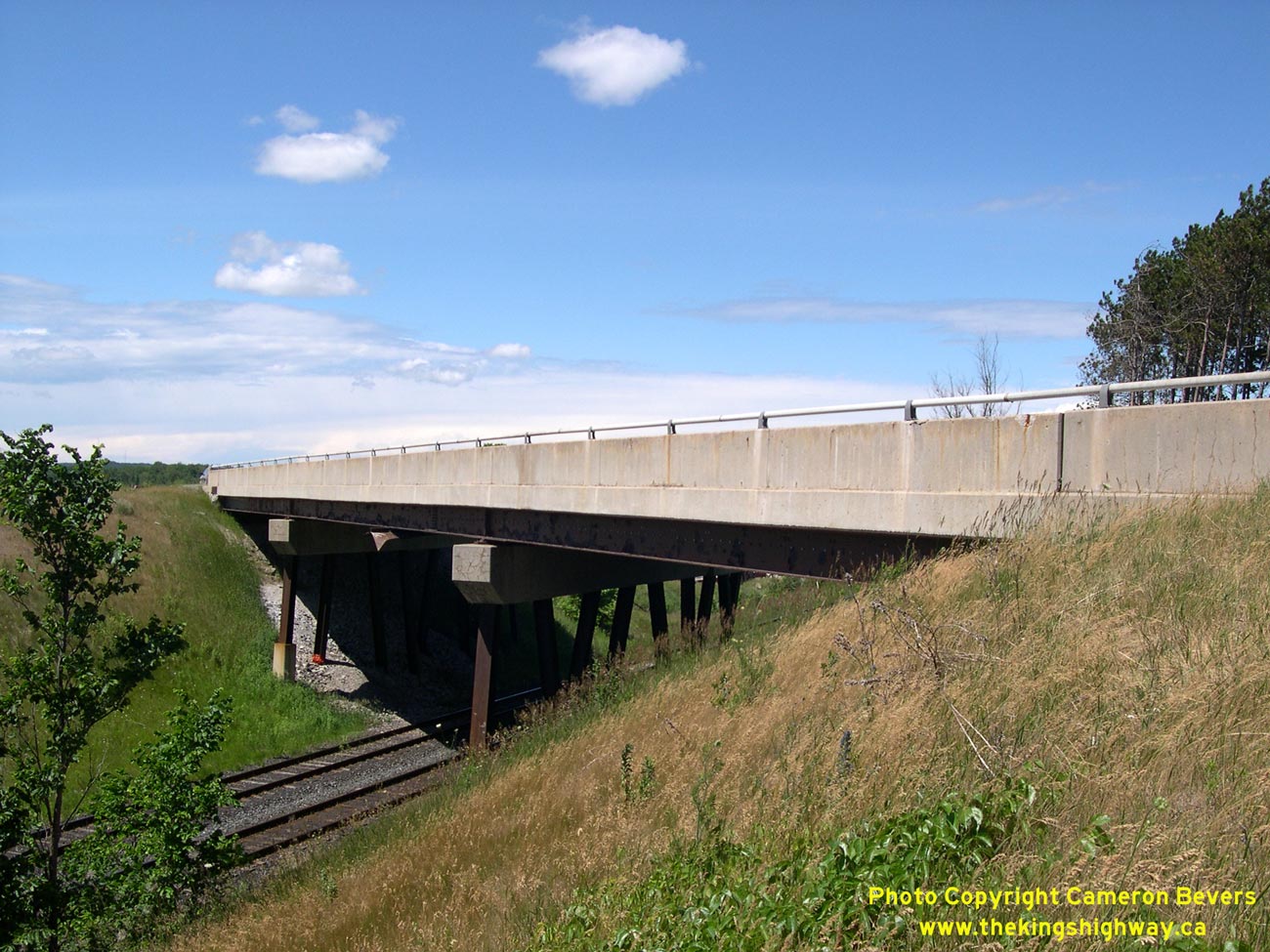
Left - Dual spans of the Craighurst Railway Overhead on Hwy 400 north of Barrie. See an
Enlarged Photo Here. (Photograph taken on June 30, 2007 - © Cameron Bevers) Right - The northbound Hwy 400 span was completed in 1959. Note the metal steam guard above the railway tracks at right, which protected the structural steel girders from corrosion from the exhaust expelled by older steam-powered railway locomotives. See an Enlarged Photo Here. (Photograph taken on June 30, 2007 - © Cameron Bevers) 

Left - View underneath the northbound (1959) Hwy 400 span. The original 1959 structure was widened slightly on the eastern side in 1979 when a deceleration
lane was built to service the adjacent Horseshoe Valley Road Interchange. See an
Enlarged Photo Here. (Photograph taken on June 30, 2007 - © Cameron Bevers) Right - The southbound Hwy 400 span was completed in 1979, when Hwy 400 was widened from two to four lanes. The 1979 structure is almost identical in design to its 1959 counterpart. See an Enlarged Photo Here. (Photograph taken on June 30, 2007 - © Cameron Bevers) 

Left - Date stamp (1979) on the Craighurst Railway Overhead. See an
Enlarged Photo Here. (Photograph taken on June 30, 2007 - © Cameron Bevers) Right - Western side of the Craighurst Railway Overhead north of Barrie. See an Enlarged Photo Here. (Photograph taken on June 30, 2007 - © Cameron Bevers) 

Left - The most peculiar feature of the Craighurst Overhead is the pier design, which is comprised of a series of pile-driven steel "H" beams positioned at
varying angles. See an Enlarged Photo Here. (Photograph taken on June 30, 2007 - © Cameron Bevers) Right - View of the southbound (1979) span's superstructure and steel "H" beam bents. See an Enlarged Photo Here. (Photograph taken on June 30, 2007 - © Cameron Bevers) 

Left - The northbound (1959) structure has similar steel "H" beam bents. The bents were angled to provide greater structural rigidity in an area with
relatively poor soil conditions. See an Enlarged Photo Here. (Photograph taken on June 30, 2007 - © Cameron Bevers) Right - Profile view of the 1959 pier, showing the angled "H" beam bents. See an Enlarged Photo Here. (Photograph taken on June 30, 2007 - © Cameron Bevers) 

Left - The Horseshoe Valley Road deceleration lane extension has similar steel "H" beam piers. See an
Enlarged Photo Here. (Photograph taken on June 30, 2007 - © Cameron Bevers) Right - These plywood forms beneath the deck of the 1959 structure are a sign of concrete deterioration. See an Enlarged Photo Here. (Photograph taken on June 30, 2007 - © Cameron Bevers) 

Left - The northbound (1959) Hwy 400 structure was reconstructed with a new bridge deck in 2007-2008. See an
Enlarged Photo Here. (Photograph taken on June 30, 2007 - © Cameron Bevers) Right - Long exit ramp for Lower Big Chute Road on Hwy 400 near Coldwater. This ramp was actually the original route of Hwy 400 until the 1970s, when a new connection was built to Hwy 12 & Hwy 69 at Waubaushene. The ramp now serves as an access road to nearby Coldwater. See an Enlarged Photo Here. (Photograph taken on June 4, 2004 - © Cameron Bevers) 

Left - Abandoned two-lane Hwy 400 alignment at Lower Big Chute Road Exit. This part of Hwy 400 was bypassed in the late 1970s by the current four-lane highway.
See an Enlarged Photo Here. (Photograph taken on June 4, 2004 - © Cameron Bevers) Right - The Lower Big Chute Road ramp is the longest freeway off-ramp in Ontario. The former two-lane Hwy 400 alignment was converted to a one-lane off ramp, which can be seen at left. At this point, the off-ramp joins Lower Big Chute Road (at right), and heads east towards Hwy 12 at Coldwater. See an Enlarged Photo Here. (Photograph taken on June 4, 2004 - © Cameron Bevers) 

Left - Approaching the Lower Big Chute Road Junction on Hwy 12 near Coldwater. Lower Big Chute Road was once part of Hwy 400. In the late 1970s, Hwy 400 was
diverted onto a new alignment between Coldwater and Waubaushene. The bypassed section of Hwy 400 became an unposted "7000-series" highway (Hwy 7174). The route is
also signed with green-and-white "TO 400" trailblazer signs. See an Enlarged Photo Here. (Photograph taken on July 14, 2010 - © Cameron Bevers) Right - Approaching the northern terminus of Hwy 7174 (Lower Big Chute Road) at Hwy 12 near Coldwater. There was a proposal in the late 1950s to extend Hwy 400 northeasterly from Coldwater to Gravenhurst. A route was selected and a Preliminary Route Plan was designated for the proposed route in 1959. Subsequent planning studies done in the 1970s recommended an eventual twinning of the existing Waubaushene-MacTier Highway (Hwy 103, later Hwy 69) rather than the construction of a new highway link to Muskoka. As a result, the route between Coldwater and Gravenhurst was never actually built, and the designated route was legally closed in 1972. Had the Hwy 400 Extension to Gravenhurst been constructed, the highway would have crossed Hwy 12 here and continued straight ahead across the remote eastern tip of Simcoe County and up into Muskoka. The proposed route of Hwy 400 would have tied into Hwy 11 immediately south of Gravenhurst. See an Enlarged Photo Here. (Photograph taken on July 14, 2010 - © Cameron Bevers) 

Left - Facing east along Hwy 12 towards Orillia from the Lower Big Chute Road (Hwy 7174) Junction near Coldwater. See an
Enlarged Photo Here. (Photograph taken on July 14, 2010 - © Cameron Bevers) Right - This municipal signpost correctly indicates that both Hwy 12 and Lower Big Chute Road are owned by the Province of Ontario. See an Enlarged Photo Here. (Photograph taken on July 14, 2010 - © Cameron Bevers) 

Left - Facing east along Hwy 12 at the Lower Big Chute Road (Hwy 7174) Junction near Coldwater. See an
Enlarged Photo Here. (Photograph taken on July 14, 2010 - © Cameron Bevers) Right - Green guide sign marking Lower Big Chute Road on eastbound Hwy 12 near Coldwater. As is the case for nearly all routes in Ontario with a 7000-series designation, the four-digit route number is not posted along the highway. Rather, the route is signed with an actual street name (Lower Big Chute Road). See an Enlarged Photo Here. (Photograph taken on July 14, 2010 - © Cameron Bevers) 

Left - Facing south along Hwy 7174 (Lower Big Chute Road) from the Hwy 12 Junction. Lower Big Chute Road connects to Hwy 400 about 2 km to the south. See an
Enlarged Photo Here. (Photograph taken on July 14, 2010 - © Cameron Bevers) Right - Green trailblazer sign marking the route to Hwy 400 via Simcoe County Road 23 (Vasey Road) from Hwy 12. See an Enlarged Photo Here. (Photograph taken on July 14, 2010 - © Cameron Bevers) 

Left - Facing east along Hwy 12 (Vasey Road) at the Hwy 400 Interchange near Coldwater. Following the route renumbering of 2014, the route of Hwy 12 is now
clearly signed along Vasey Road from Hwy 400 to Coldwater. See an Enlarged Photo Here. (Photograph taken on September 12, 2014 - © Cameron Bevers) Right - "Junction 400 12" sign on eastbound Simcoe Road 23 (Vasey Road) approaching the Hwy 400 Interchange near Coldwater. This recently-installed sign assembly makes use of a full "Junction" sign tab, which has been a relatively uncommon signing practice on provincial highways in recent years. See an Enlarged Photo Here. (Photograph taken on September 12, 2014 - © Cameron Bevers) 

Left - Hwy 12 & Trans-Canada Highway Route Marker at the Hwy 400 Interchange near Coldwater. When Hwy 12 was downloaded between Coldwater and Waubaushene
in 1997, the Trans-Canada Highway signs along the old highway route were removed, leaving a 6 km unsigned gap in the route of the Trans-Canada Highway between
Waubaushene and Coldwater. During the route renumbering of 2014, the gap in the Trans-Canada Highway's Georgian Bay Route was finally rectified when it was applied to
the new overlapped route of Hwy 400 & Hwy 12 between Coldwater and Waubaushene. See an
Enlarged Photo Here. (Photograph taken on September 12, 2014 - © Cameron Bevers) Right - Oversized Hwy 400 & Hwy 12 route markers on eastbound Hwy 12 (Vasey Road) at the Hwy 400 Interchange near Coldwater. See an Enlarged Photo Here. (Photograph taken on September 12, 2014 - © Cameron Bevers) 
Above - New green guide signs at the Hwy 400 and Vasey Road Interchange near Coldwater, showing the new overlapped route of Hwy 400 & Hwy 12. See an
Enlarged Photo Here. (Photograph taken on September 12, 2014 - © Cameron Bevers)
Continue on to King's Highway 400 Photos: Port Severn to MacTier
|
|---|
Links to Adjacent King's Highway Photograph Pages:
Back to King's Highway 169 Photos /
King's Highway 400 History /
On to King's Highway 401 Photos
Ontario Highway History - Main Menu / Back to List of Highways Website contents, photos & text © 2002-2026, Cameron
Bevers (Webmaster) - All Rights Reserved / Contact Me
|
|---|