
| 
| |
|
|
This page contains historical photos of Ontario's King's Highway 403 dating from 1956 to 1979. All photographs displayed on
this page were taken by the Ontario Ministry of Transportation, unless specifically noted otherwise. Historical photographs are arranged in approximate chronological
order. Click on any thumbnail to see a larger image!
Please note that all photographs displayed on this
website are protected by copyright. These photographs must not be reproduced, published,
electronically stored or copied, distributed, or posted onto other websites without
my written permission. If you want to use photos from this website, please
email me first for permission. Thank-you!
|
|---|
|
Page 1: Historical King's Highway 403 Photographs (1956-1979)

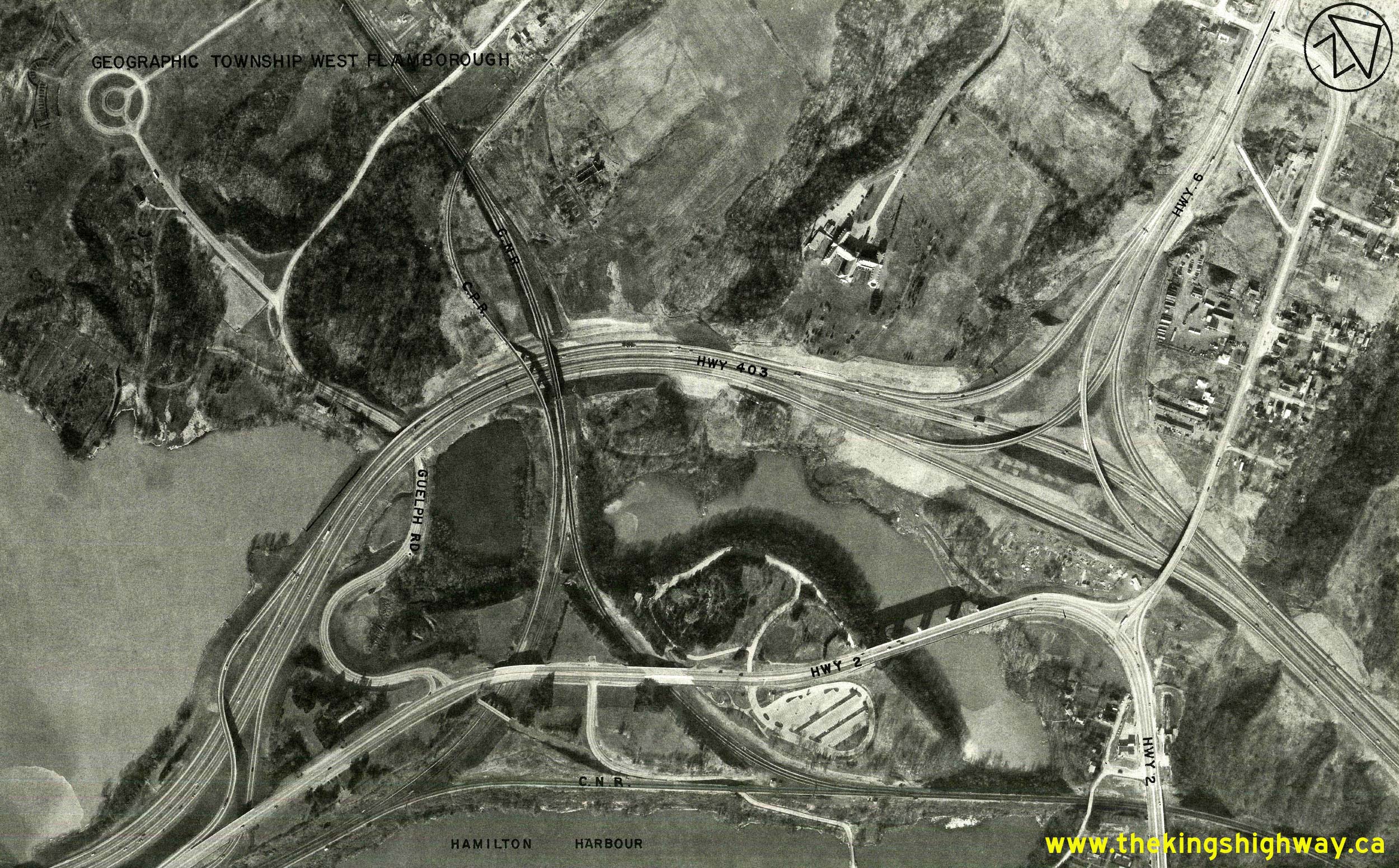
Above - Heavy grading at the proposed Freeman Interchange at the future junction of the Queen Elizabeth Way and Hwy 403 in Burlington. About 2 miles of the
Queen Elizabeth Way was relocated onto an improved alignment between Plains Road at Campbell's Corners and Guelph Line in the late 1950s. Known as the Freeman
Diversion, this relocated section of the Queen Elizabeth Way bypassed the community of Freeman situated at the intersection of Brant Street and Plains Road (the Old
Queen Elizabeth Way). See an Enlarged Photo Here. Photo taken on November 6, 1956. (Photo courtesy of Ontario Ministry of Transportation - © King's Printer for Ontario, 1956) 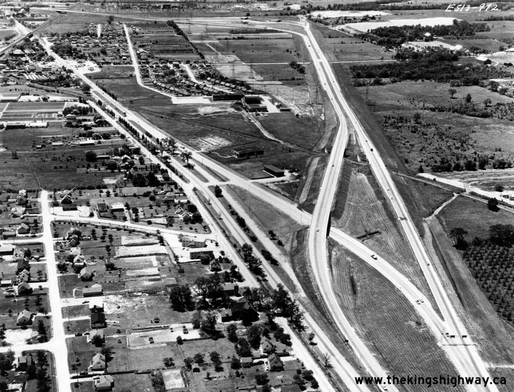
Above - Aerial view of the Freeman Diversion on the Queen Elizabeth Way in Burlington, facing west towards the future Hwy 403 Interchange in 1960. This photo
shows the completed Freeman Diversion on the Queen Elizabeth Way in Burlington, which was completed in 1958. The Freeman Diversion bypassed the community of Freeman
and provided improved access to the Burlington Bay Skyway from the Toronto leg of the Queen Elizabeth Way. The construction of the Freeman Diversion also permitted
connections to the proposed route of Hwy 403 between Hamilton and Burlington at the Freeman Interchange. The three bridges at the proposed Freeman Interchange were
built in 1957, well in advance of the remainder of the Burlington section of Hwy 403. The three Hwy 403 Interchange structures can be seen standing in a field in the
background of this photo. The county road passing under the Freeman Diversion in the background is today's Brant Street. The bypassed portion of the original Queen
Elizabeth Way through the community of Freeman follows today's Plains Road, seen in this photo at upper-left. See an
Enlarged Photo Here. Photo taken in June 1960. (Photo © Archives of Ontario - RG-14-151-5-26, Box B1106, Photo #ES-13-972) 
Above - Map showing the proposed route of Hwy 403 between Burlington and Hwy 2 near Ancaster in 1962. This multi-year freeway construction project took more
than a decade to complete, from the time work began at the Freeman Interchange in the mid-1950s to the final completion of the Ancaster Extension in 1969. Hwy 403
effectively supplanted the route of Hwy 2 between Burlington and Ancaster. See an
Enlarged Photo Here. (Photo courtesy of Ontario Ministry of Transportation - © King's Printer for Ontario, 1962) 

Left - Construction of the Lemonville Road Overpass on the proposed route of Hwy 403 near Ancaster in 1962. See an
Enlarged Photo Here. (Photo courtesy of Ontario Ministry of Transportation - © King's Printer for Ontario, 1962) Right - Flyover from eastbound Hwy 403 to northbound Hwy 6 (Ramp "Q") between Burlington and Hamilton in 1963, prior to deck paving. Due to Hwy 403's construction sequencing, the Hwy 6 & Hwy 403 Interchange sat unopened for more than two years following its construction in 1960-1961. Note that in this photo, the grading for the future westbound lanes of Hwy 403 below the structures had been completed, but the roadway itself hadn't been built yet. A final paving contract for Hwy 403 was awarded in 1963, in preparation for the highway's opening later that year. The Hwy 6 Interchange opened to traffic along with the rest of Hwy 403 between Burlington and the Desjardins Canal in Hamilton on December 4, 1963. See an Enlarged Photo Here. Photo taken in 1963. (Photo courtesy of Ontario Ministry of Transportation - © King's Printer for Ontario, 1963) 

Left - Steel girder placement at the King Street (Hwy 2 & Hwy 8) Overpass in 1963, prior to concrete deck pouring. Following the completion of the King
Street Overpass across the proposed route of Hwy 403 in Downtown Hamilton, all westbound traffic on Hwy 8 was routed over the freeway on this large structure. Once
the first phase of Hwy 403 opened to traffic in late 1963, Hwy 2 was also rerouted via King Street & Main Street, concurrently with Hwy 8. At right, the old King
Street viaduct across the valley can be seen beside the new bridge. The old viaduct was demolished during the King Street & Main Street Interchange's construction
in the 1960s. See an Enlarged Photo Here. Photo taken in 1963. (Photo courtesy of Ontario Ministry of Transportation - © King's Printer for Ontario, 1963) Right - Map showing the construction progress of the Brantford Bypass (Hwy 403) at the beginning of the 1964 construction season. The construction of the Brantford Bypass in the 1960s greatly relieved traffic congestion on existing Hwy 2 through Brantford. See an Enlarged Photo Here. (Photo courtesy of Ontario Ministry of Transportation - © King's Printer for Ontario, 1964) 
Above - Grading operations underway on the Brantford Bypass (Hwy 403) in 1964. See an
Enlarged Photo Here. (Photo courtesy of Ontario Ministry of Transportation - © King's Printer for Ontario, 1964) 

Left - T.H. & B. Railway Overhead under construction on the Brantford Bypass (Hwy 403) just north of Cainsville, Contract #1963-03. See an
Enlarged Photo Here. Photo taken in 1964. (Photo courtesy of Ontario Ministry of Transportation - © King's Printer for Ontario, 1964) Right - Facing west along a newly-opened section of Hwy 403 approaching the Hwy 6 Interchange between Burlington and Hamilton in 1964. This photo shows the new freeway about 6 months after opening day. Compared to the heavy traffic volumes carried along Hwy 403 today, the low traffic volumes seen in this 1964 photo certainly speaks to the incredible economic growth that Ontario has experienced in recent decades. Much of this prosperity was due to the massive investments made by the province since World War II in building new highways such as this one. See an Enlarged Photo Here. Photo taken in May 1964. (Photo courtesy of Ontario Ministry of Transportation - © King's Printer for Ontario, 2021) 
Above - Map showing the construction progress of Hwy 403 between Burlington and Hwy 2 near Ancaster at the beginning of the 1964 construction season. See an
Enlarged Photo Here. (Photo courtesy of Ontario Ministry of Transportation - © King's Printer for Ontario, 1964) 

Left - Facing south across the Ramp "M" Overpass at the Hwy 2 & Hwy 6 (York Boulevard) Interchange on Hwy 403 in Hamilton. This ramp carries traffic from
westbound Hwy 403 to the T.B. McQuesten High-Level Bridge on York Boulevard. At the time this photo was taken in 1964, it was actually the last exit ramp on Hwy 403
before the freeway came to an end at Longwood Road. See an
Enlarged Photo Here. Photo taken in May 1964. (Photo courtesy of Ontario Ministry of Transportation - © King's Printer for Ontario, 2021) Right - Approaching the Ramp "M" Overpass near the western terminus of Hwy 403 in Hamilton in 1964. For about 1 1/2 years, the route of Hwy 403 temporarily ended at the Desjardins Canal while the interchanges through Downtown Hamilton were being constructed. Note the signs placed on both sides of the westbound lanes in this photo, warning motorists that Hwy 403 ends 3000 feet ahead. All westbound traffic was forced off of the freeway and onto Longwood Road (Old Hwy 2) just beyond the Desjardins Canal Bridge. The construction of Hwy 403 actually severed the Hwy 2 connection between Longwood Road and York Boulevard. Beginning in 1963, Hwy 2 was rerouted via York Boulevard, Dundurn Street and King & Main Street. See an Enlarged Photo Here. Photo taken in May 1964. (Photo courtesy of Ontario Ministry of Transportation - © King's Printer for Ontario, 2021) 

Left - Hwy 2 & Hwy 6 (York Boulevard) at the Hwy 403 Interchange in 1964, facing south towards the Ramp "N" Underpass structure and T.B. McQuesten
High-Level Bridge in Hamilton. During construction of Hwy 403 in the early 1960s, a partial interchange was built to connect the new freeway to York Boulevard.
Historically, Hwy 6 used to follow York Boulevard into Downtown Hamilton. The construction of Hwy 403 in the early 1960s changed the routing of Hwy 2 & Hwy 6 as
these highways approached Hamilton. Previously, Hwy 2 turned west towards Dundas via Longwood Road, which connected to York Boulevard at a traffic circle about 2
miles north of Downtown Hamilton. The route of Hwy 6 followed Plains Road from south of Clappison's Corners to the community of Wolfe Island, where the highway turned
south onto York Boulevard towards Downtown Hamilton, concurrently with Hwy 2. The new directional freeway interchange built at Hwy 6 & Hwy 403 was actually
considered to be an extension of Hwy 6, with through traffic encouraged to use the freeway route into Downtown Hamilton instead of the original route of Hwy 6 via
Wolfe Island. The freeway ramps to and from Hwy 403 can be seen connecting to York Boulevard immediately north of the T.B. McQuesten High-Level Bridge in the
background of this photo. See an Enlarged Photo Here. Photo taken in May 1964. (Photo courtesy of Ontario Ministry of Transportation - © King's Printer for Ontario, 2014) Right - Ramp "N" Underpass on Hwy 2 & Hwy 6 (York Boulevard) in 1964. For many years, this ramp carried northbound Hwy 6 traffic onto eastbound Hwy 403. Following a brief 1/2 mile concurrent routing with Hwy 403, Hwy 6 departed the freeway and headed north towards Clappison's Corners and Guelph. This route of Hwy 6 approaching Downtown Hamilton remained in place until the late 1990s. The old route of Hwy 6 through Downtown Hamilton was bypassed entirely when the Lincoln Alexander Parkway opened to traffic. See an Enlarged Photo Here. Photo taken in May 1964. (Photo courtesy of Ontario Ministry of Transportation - © King's Printer for Ontario, 2014) 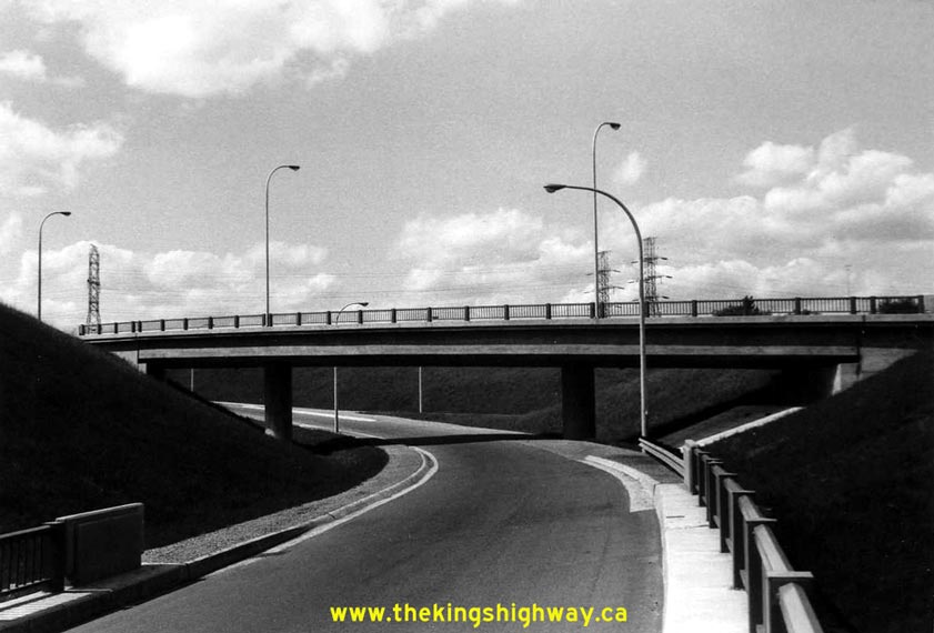

Left - Grade separation at the Hwy 6 Interchange on Hwy 403 between Burlington and Hamilton in 1964. This structure carries the ramp connecting southbound
Hwy 6 to eastbound Hwy 403 (Ramp "R"). The roadway in the foreground is the ramp from eastbound Hwy 403 to northbound Hwy 6 (Ramp "Q"). This interesting three-level
fully directional interchange was built in 1960-1961, in advance of the construction of the mainline lanes of Hwy 403. This interchange was put into service in
December 1963, only six months before this photo was taken. A similar but much larger fully directional interchange was built at the nearby Freeman Interchange, where
Hwy 403 joins the Queen Elizabeth Way. See an Enlarged Photo Here. Photo taken in May 1964. (Photo courtesy of Ontario Ministry of Transportation - © King's Printer for Ontario, 2014) Right - Ramp "R" Flyover from southbound Hwy 6 to eastbound Hwy 403 at the Hwy 6 Interchange between Burlington and Hamilton. See an Enlarged Photo Here. Photo taken in May 1964. (Photo courtesy of Ontario Ministry of Transportation - © King's Printer for Ontario, 2014) 

Left - Facing north across the Ramp "Q" Flyover from eastbound Hwy 403 to northbound Hwy 6, crossing the westbound lanes of Hwy 403. See an
Enlarged Photo Here. Photo taken in May 1964. (Photo courtesy of Ontario Ministry of Transportation - © King's Printer for Ontario, 2021) Right - Westbound lanes of Hwy 403 at the Ramp "Q" Flyover to northbound Hwy 6, facing east towards Burlington. See an Enlarged Photo Here. Photo taken in May 1964. (Photo courtesy of Ontario Ministry of Transportation - © King's Printer for Ontario, 2021) 

Left - Facing west along Hwy 403 from Snake Road towards the Hwy 6 Interchange between Hamilton and Burlington in 1964. It is interesting to note that Hwy 403
was built with six traffic lanes right from the onset between Burlington and Hamilton. Many Ontario freeways built in the early 1960s were designed to ultimately
become six-lane freeways, but were initially only built as four-lane freeways. Thanks to the foresight of highway designers at that time, this section of Hwy 403 was
designed with sufficient lane capacity to last for several decades. As a result, the highway has never undergone any substantial reconstruction or widening, apart
from some periodic, localized improvements. Apart from the obvious growth in traffic volumes over the past 55-plus years, this section of the freeway essentially
looks the same today as it did when this photo was taken in 1964 - a rarity for freeways in this part of Ontario. See an
Enlarged Photo Here. Photo taken in May 1964. (Photo courtesy of Ontario Ministry of Transportation - © King's Printer for Ontario, 2014) Right - Dual underpass structures on Hwy 403 at Snake Road between Hamilton and Burlington. See an Enlarged Photo Here. Photo taken in May 1964. (Photo courtesy of Ontario Ministry of Transportation - © King's Printer for Ontario, 2014) 

Left - Lemonville Road Overpass across Hwy 403 in 1964, facing south towards Aldershot. See an
Enlarged Photo Here. Photo taken in May 1964. (Photo courtesy of Ontario Ministry of Transportation - © King's Printer for Ontario, 2021) Right - Facing west along the westbound lanes of Hwy 403 towards the Lemonville Road Overpass near Aldershot in 1964. See an Enlarged Photo Here. Photo taken in May 1964. (Photo courtesy of Ontario Ministry of Transportation - © King's Printer for Ontario, 2021) 

Left - Hidden Valley Road Tunnel underneath Hwy 403 north of Aldershot in 1964. This interesting concrete barrel arch structure is virtually hidden from view
from the highway at the bottom of a deep ravine, just west of the Waterdown Road Overpass. The adjacent structure at Grindstone Creek is also a concrete barrel arch
structure. See an Enlarged Photo Here. Photo taken in May 1964. (Photo courtesy of Ontario Ministry of Transportation - © King's Printer for Ontario, 2014) Right - Grindstone Creek Culvert underneath Hwy 403 near the Hidden Valley Road Tunnel north of Aldershot. See an Enlarged Photo Here. Photo taken in May 1964. (Photo courtesy of Ontario Ministry of Transportation - © King's Printer for Ontario, 2014) 

Left - Facing west along Hwy 403 towards Waterdown Road north of Aldershot in 1964. When Hwy 403 was first constructed in the early 1960s, there was no interchange at
Waterdown Road. A partial two-ramp interchange was built here in 1977, which was later upgraded to a full interchange a few years ago. See an
Enlarged Photo Here. Photo taken in May 1964. (Photo courtesy of Ontario Ministry of Transportation - © King's Printer for Ontario, 2014) Right - Facing south along Waterdown Road towards Hwy 403 north of Aldershot. See an Enlarged Photo Here. Photo taken in May 1964. (Photo courtesy of Ontario Ministry of Transportation - © King's Printer for Ontario, 2014) 

Left - Facing west along Hwy 403 towards King Road in Burlington. See an
Enlarged Photo Here. Photo taken in May 1964. (Photo courtesy of Ontario Ministry of Transportation - © King's Printer for Ontario, 2014) Right - Facing south across the King Road Overpass on Hwy 403 in Burlington. The Burlington Bay Skyway can be seen in the background. See an Enlarged Photo Here. Photo taken in May 1964. (Photo courtesy of Ontario Ministry of Transportation - © King's Printer for Ontario, 2014) 

Left - View of the original Freeman Interchange at the Queen Elizabeth Way and Hwy 403 in Burlington. The ramp in the foreground carries eastbound traffic on
Hwy 403 across the ramp from the Toronto-bound Queen Elizabeth Way to westbound Hwy 403. See an
Enlarged Photo Here. Photo taken in June 1964. (Photo courtesy of Ontario Ministry of Transportation - © King's Printer for Ontario, 2013) Right - Grade separation at the Freeman Interchange in Burlington in 1964. Three nearly identical structures were built at this interchange in 1957 to carry the connecting ramps between Hwy 403 and the Queen Elizabeth Way. Although the interchange was not fully opened to traffic until December 1963, the Freeman Interchange was one of the earliest high-speed freeway-to-freeway interchanges designed in Ontario. The Freeman Interchange marked a radical departure from the traditional cloverleaf and other lower-speed interchange designs that typified most freeway-to-freeway junctions built in Ontario prior to 1957. See an Enlarged Photo Here. Photo taken in June 1964. (Photo courtesy of Ontario Ministry of Transportation - © King's Printer for Ontario, 2013) 
Above - Map showing the new section of Hwy 403 being opened through Downtown Hamilton in 1965. The 2 mile section of Hwy 403 from the Desjardins Canal to
Aberdeen Avenue opened to traffic on July 9, 1965. However, various ramps at the Hwy 2 & Hwy 8 (King & Main Street) Interchange didn't open until a later
date, due to construction sequencing. See an Enlarged Photo Here. (Photo courtesy of Ontario Ministry of Transportation - © King's Printer for Ontario, 1965) 
Above - Aerial view of the Hwy 2 & Hwy 8 (King Street & Main Street) Interchange on Hwy 403 in Downtown Hamilton facing east, just prior to opening in
1965. This interesting three-level interchange was built as part of a series of interchange connections between Hwy 403 and Downtown Hamilton's arterial streets. See
an Enlarged Photo Here. (Photo courtesy of Ontario Ministry of Transportation - © King's Printer for Ontario, 1965) 
Above - Map showing the construction progress of Hwy 403 between Burlington and Hwy 2 near Ancaster at the beginning of the 1966 construction season. See an
Enlarged Photo Here. (Photo courtesy of Ontario Ministry of Transportation - © King's Printer for Ontario, 1966) 

Left - Hot-mix paving operations on the eastern leg of the Brantford Bypass (Hwy 403) approaching Cainsville, Contract #1965-202. See
an Enlarged Photo Here. Photo taken in 1966. (Photo courtesy of Ontario Ministry of Transportation - © King's Printer for Ontario, 1966) Right - Rock cut construction along Hwy 403 at Hamilton Mountain, Contract #1966-200. See an Enlarged Photo Here. Photo taken in 1967. (Photo courtesy of Ontario Ministry of Transportation - © King's Printer for Ontario, 1967) 

Left - Hwy 403 at the Desjardins Canal Bridge in Hamilton in 1967, facing east towards Burlington across the westbound structure. The eastbound lanes of Hwy 403
can be seen at right, along with the T.B. McQuesten High-Level Bridge on Hwy 2 & Hwy 6 (York Boulevard). See an
Enlarged Photo Here. Photo taken in May 1967. (Photo courtesy of Ontario Ministry of Transportation - © King's Printer for Ontario, 2014) Right - Facing west along Hwy 403 approaching Downtown Hamilton in 1967. This photo shows what Hwy 403 looked like when it opened in the 1960s, with its curved luminaires and open grass median. Overhead signs on Hwy 403 through Hamilton were illuminated using fluorescent tube lights, as opposed to the conventional catwalk-mounted floodlights that were normally used to illuminate overhead freeway signs in Ontario. At the time this photo was taken, Hwy 403 ended just beyond the Main Street & King Street Interchange which is visible in the background. See an Enlarged Photo Here. Photo taken in May 1967. (Photo courtesy of Ontario Ministry of Transportation - © King's Printer for Ontario, 2011) 
Above - Macklin Street Underpass on Hwy 403 in Hamilton, facing south. Photo taken in May 1967. (Photo courtesy of Ontario Ministry of Transportation - © King's Printer for Ontario, 2012) 
Above - New T.H.& B. Railway Subway in Downtown Hamilton on the future Ancaster Extension of Hwy 403, Contract #1967-12.
Photo taken in 1968. (Photo courtesy of Ontario Ministry of Transportation - © King's Printer for Ontario, 1968) 

Left - View of Hwy 403 approaching the Mohawk Road Interchange in Hamilton, just prior to opening in 1969. Although it isn't obvious in this photo, there is
actually nobody driving the car seen on the westbound lanes. Presumably, the car belonged to the DHO photographer who decided to stop here to take this fantastic
photo of Hwy 403 prior to opening. See an Enlarged Photo Here. (Photo courtesy of Ontario Ministry of Transportation - © King's Printer for Ontario, 1969) Right - Ramp "D" Overpass connecting Main Street to eastbound Hwy 403 in Hamilton. Between 1965 and 1969, Hwy 403 essentially began at this on-ramp. All traffic coming from Brantford and London on Hwy 2 had to use this on-ramp from Main Street to access eastbound Hwy 403. Westbound Hwy 403 traffic could exit to either Main Street or Aberdeen Avenue. Photo taken in April 1970. (Photo courtesy of Ontario Ministry of Transportation - © King's Printer for Ontario, 2011) 

Left - Facing west along Hwy 403 towards the Aberdeen Avenue Interchange in Hamilton in 1970. This photo shows the new highway only a few months after it was
opened to traffic between Downtown Hamilton and Hwy 2 in Ancaster in 1969. Photo taken in April 1970. (Photo courtesy of Ontario Ministry of Transportation - © King's Printer for Ontario, 2011) Right - Facing north across the Aberdeen Avenue Overpass on Hwy 403 in Hamilton. Photo taken in April 1970. (Photo courtesy of Ontario Ministry of Transportation - © King's Printer for Ontario, 2011) 

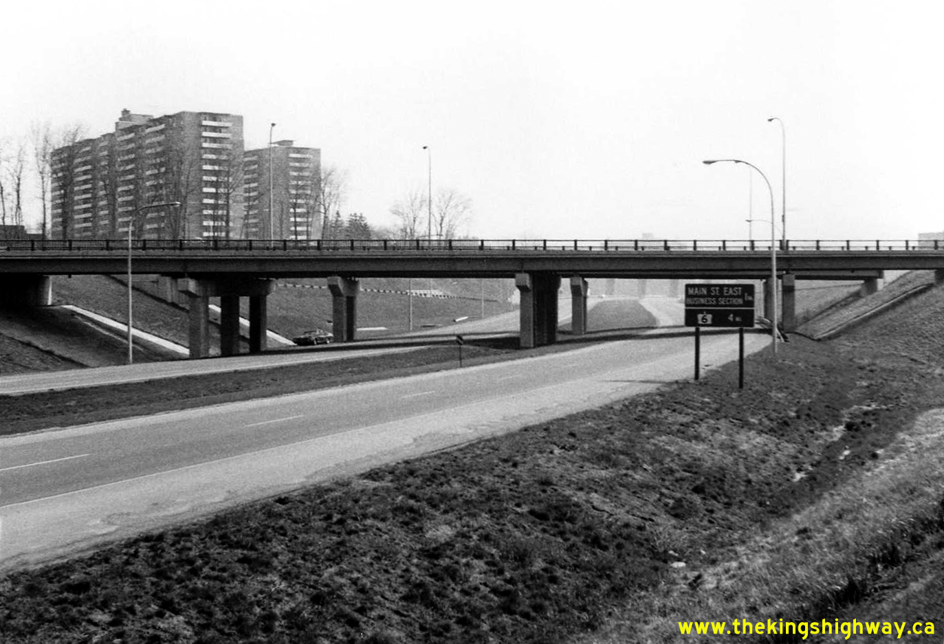
Left - Aberdeen Avenue Interchange on Hwy 403 in Hamilton in 1970, facing east towards Burlington. Note the pre-Metric distance guide sign at right, indicating
the distances to Main Street East - Business Section (1 mile) and Hwy 6 (4 miles). See an
Enlarged Photo Here. Photo taken in April 1970. (Photo courtesy of Ontario Ministry of Transportation - © King's Printer for Ontario, 2011) Right - Facing north across the Hamilton Drive Overpass on Hwy 403 in Ancaster. Photo taken in April 1970. (Photo courtesy of Ontario Ministry of Transportation - © King's Printer for Ontario, 2012) 

Left - Hwy 403 at Hamilton Drive in Ancaster, facing east towards Hamilton. Photo taken in April 1970. (Photo courtesy of Ontario Ministry of Transportation - © King's Printer for Ontario, 2012) Right - Facing north across the Mohawk Road Overpass on Hwy 403 in Ancaster. Photo taken in April 1970. (Photo courtesy of Ontario Ministry of Transportation - © King's Printer for Ontario, 2012) 
Above - Facing east along Hwy 403 towards Downtown Hamilton at the Mohawk Road Interchange in Ancaster. Photo taken in April 1970. (Photo courtesy of Ontario Ministry of Transportation - © King's Printer for Ontario, 2012) 

Left - Facing north across the Fiddler's Green Road Overpass towards Downtown Ancaster. See an
Enlarged Photo Here. Photo taken in April 1970. (Photo courtesy of Ontario Ministry of Transportation - © King's Printer for Ontario, 2014) Right - Facing east along Hwy 403 at the Fiddler's Green Road Overpass in Ancaster in 1970. When the Hwy 403 Ancaster Extension opened to traffic in 1969, there was no interchange at Fiddler's Green Road. As originally designed, the only two interchanges along Hwy 403 in Ancaster were at Mohawk Road and Hwy 2 (Wilson Street). A partial two-ramp interchange was built on Hwy 403 at Fiddler's Green Road in 1985. See an Enlarged Photo Here. Photo taken in April 1970. (Photo courtesy of Ontario Ministry of Transportation - © King's Printer for Ontario, 2014) 

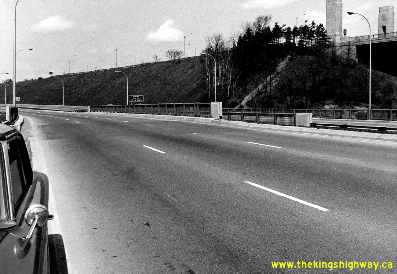
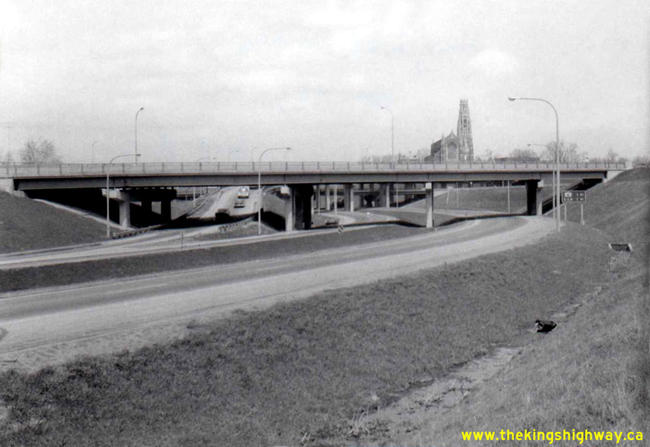
Left - Facing east towards Downtown Ancaster across the Hwy 2 (Wilson Street) Overpass at Hwy 403. See an
Enlarged Photo Here. Photo taken in April 1970. (Photo courtesy of Ontario Ministry of Transportation - © King's Printer for Ontario, 2014) Right - End of the Hwy 403 Ancaster Extension at the Hwy 2 Interchange in 1970. When the Hwy 403 Ancaster Extension opened to traffic in August 1969, the freeway ended at Hwy 2 (Wilson Street), just west of Ancaster. From this interchange, all westbound traffic had to follow Hwy 2 westerly towards Brantford, where Hwy 403 resumed once again. This interesting photo shows the completed Hwy 2 structure and grading for the future lanes of Hwy 403. Up until the 1990s, the only traffic that passed underneath this grade separation was traffic coming from Downtown Ancaster along westbound Hwy 2 heading for eastbound Hwy 403. The loop ramp from westbound Hwy 2 can be seen entering the future eastbound lanes of Hwy 403 at left. Westbound Hwy 403 traffic did not pass below this structure at all for many years. Instead, westbound Hwy 403 traffic joined into westbound Hwy 2 via a long, curved ramp which passed below Hwy 2 through a second structure immediately to the east of the main Hwy 2 Overpass seen here. The second structure at this interchange was removed in the 1990s, when Hwy 403 was extended west to Brantford. Part of the long curve carrying the westbound Hwy 403 ramp to Hwy 2 can be seen in the background on the far side of the structure. The interchange configuration seen here remained more or less the same until 1996, when a construction contract was called to extend the lanes of Hwy 403 from this interchange westerly to Hwy 52. The long-overdue and badly-needed section of Hwy 403 between Brantford and Ancaster was finally completed and opened to traffic in 1997. See an Enlarged Photo Here. Photo taken in April 1970. (Photo courtesy of Ontario Ministry of Transportation - © King's Printer for Ontario, 2014) 

Left - Facing east along Hwy 403 at Snake Road between Burlington and Hamilton. See an
Enlarged Photo Here. Photo taken in April 1970. (Photo courtesy of Ontario Ministry of Transportation - © King's Printer for Ontario, 2014) Right - Dual underpass structures on Hwy 403 at Snake Road between Hamilton and Burlington. See an Enlarged Photo Here. Photo taken in April 1970. (Photo courtesy of Ontario Ministry of Transportation - © King's Printer for Ontario, 2014) 

Left - Eastbound Hwy 2 & Hwy 8 (Main Street) Interchange on Hwy 403 in 1972, facing east towards Burlington. Note the ground-mounted interchange sequence
guide sign at left, advising motorists of the distance to the Hwy 6 and the Queen Elizabeth Way Interchanges. At the time this photo was taken, Hwy 6 was the only
interchange along Hwy 403 between Downtown Hamilton and the Queen Elizabeth Way at the Freeman Interchange. The exit ramp at Waterdown Road wasn't built until 1977.
See an Enlarged Photo Here. Photo taken in April 1972. (Photo courtesy of Ontario Ministry of Transportation - © King's Printer for Ontario, 2014) Right - Facing east along Hwy 2 & Hwy 8 East (Main Street) in Hamilton at the Hwy 403 Interchange. See an Enlarged Photo Here. Photo taken in April 1972. (Photo courtesy of Ontario Ministry of Transportation - © King's Printer for Ontario, 2014) 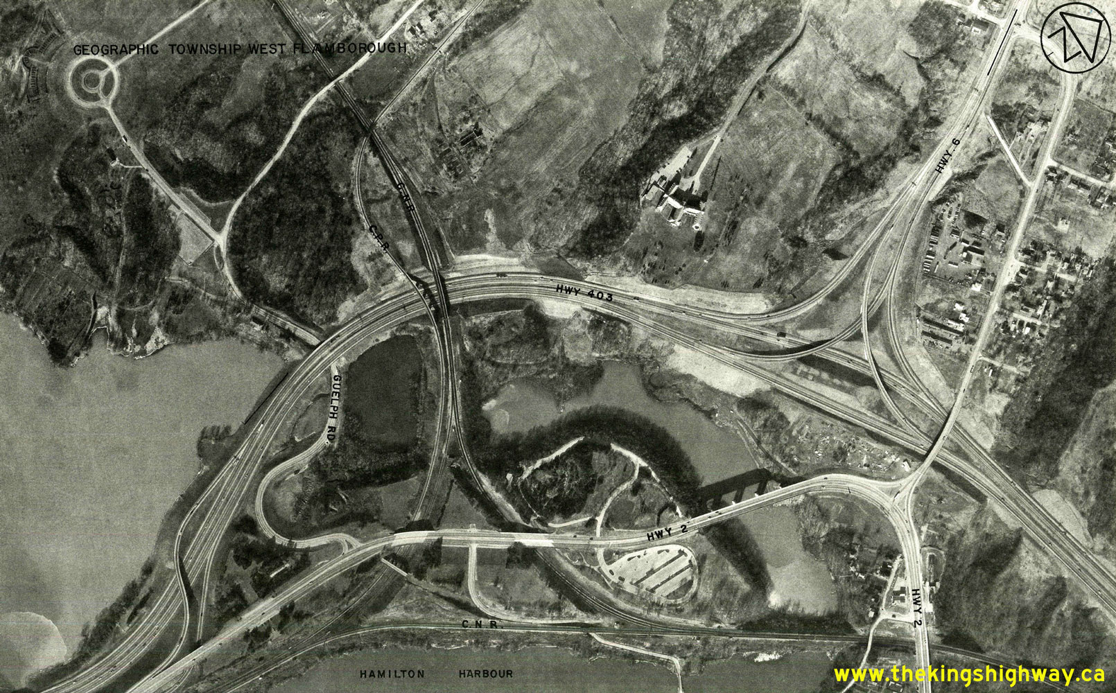
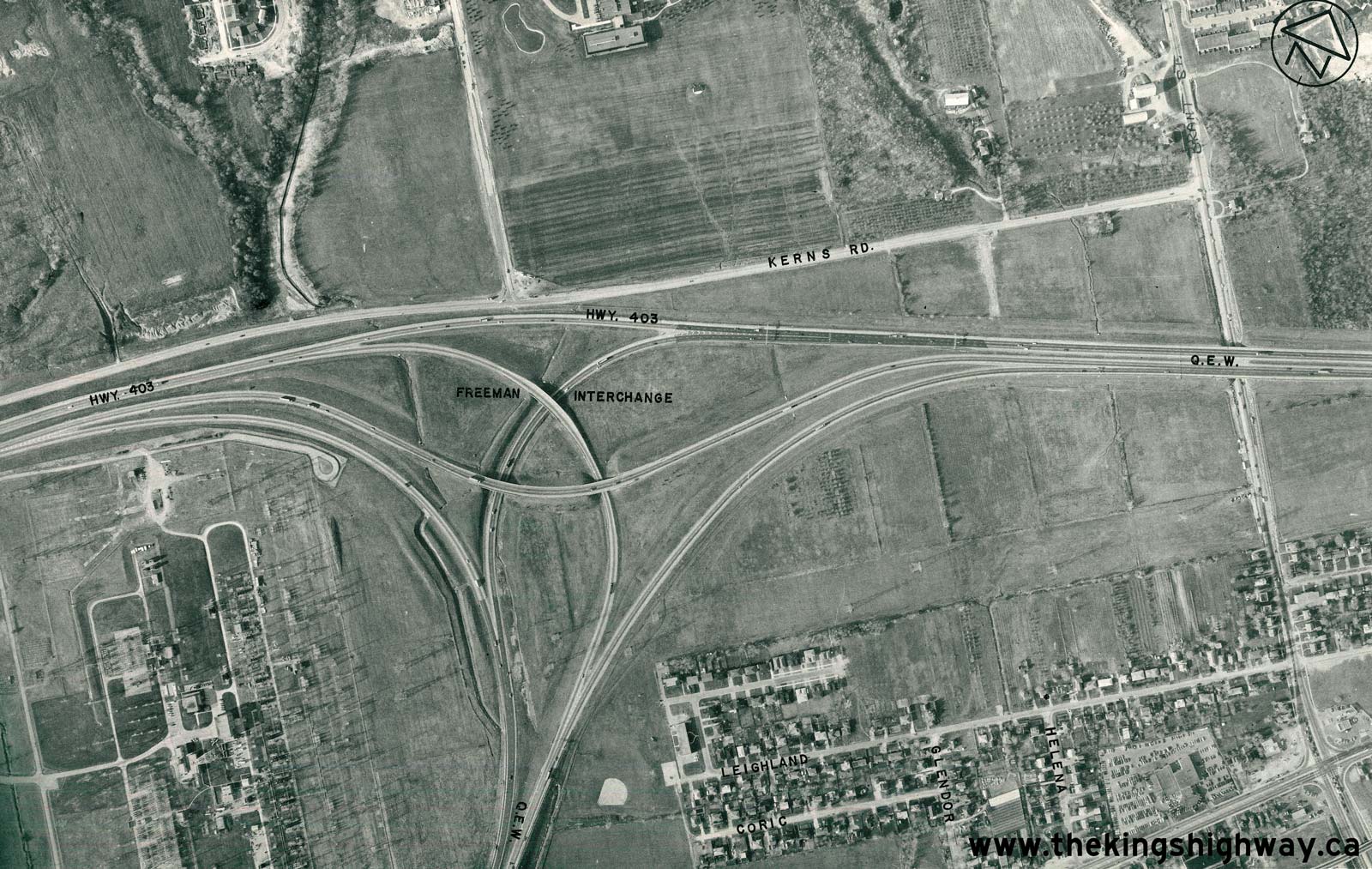
Above - Aerial view of Hwy 403 at the Hwy 6 Interchange near Aldershot, located between Hamilton and Burlington. See an
Enlarged Photo Here. Photo taken in 1973. (Photo courtesy of Ontario Ministry of Transportation - © King's Printer for Ontario, 2026) 
Above - Aerial view of Hwy 401 at the future site of the Hwy 403 & Hwy 410 Interchange in Mississauga in 1973. The new freeway interchange was built
immediately east of the First Line (Kennedy Road) Overpass. Construction got underway on the first phase of the Hwy 403 & Hwy 410 Interchange in 1974, shortly
after this photo was taken. See an Enlarged Photo Here. Photo taken in 1973. (Photo courtesy of Ontario Ministry of Transportation - © King's Printer for Ontario, 2013) 
Above - Aerial view of the Hwy 2 & Hwy 403 Interchange west of Ancaster in 1974. This "trumpet" interchange marked the western terminus of the
Burlington-to-Ancaster leg of Hwy 403 from 1969 up until 1997. Until Hwy 403 was extended to Brantford in 1997, all westbound Hwy 403 traffic had to use Hwy 2 in
order to reach Brantford. The outer directional ramp carrying westbound traffic on Hwy 403 to westbound Hwy 2 was removed during reconstruction of this interchange in
1996-1997. See an Enlarged Photo Here. Photo taken in 1974. (Photo courtesy of Ontario Ministry of Transportation - © King's Printer for Ontario, 2016) 
Above - Aerial view of the Queen Elizabeth Way at the Freeman Interchange in 1974. This photo shows the fully-directional interchange constructed at the
junction of Hwy 403 and the Queen Elizabeth Way. The Freeman Interchange was one of the earliest high-speed freeway-to-freeway interchanges designed in Ontario. The
interchange was partially opened to traffic with the completion of the Freeman Diversion on the Queen Elizabeth Way in 1958. The interchange was put into full
operation when Hwy 403 was opened to traffic between Burlington and Hamilton in December 1963. The original Freeman Interchange seen here was replaced with a new
interchange during an ambitious multi-year construction project which began in 1991. See an
Enlarged Photo Here. Photo taken in 1974. (Photo courtesy of Ontario Ministry of Transportation - © King's Printer for Ontario, 2014) 

Left - Southern side of the Macklin Street Underpass on Hwy 403 in Hamilton. Photo taken on November 29, 1977. (Photo courtesy of Ontario Ministry of Transportation - © King's Printer for Ontario, 2012) Right - Facing west along Hwy 403 towards Downtown Hamilton from the Macklin Street Underpass. See an Enlarged Photo Here. Photo taken on November 29, 1977. (Photo courtesy of Ontario Ministry of Transportation - © King's Printer for Ontario, 2012) 

Left - Facing east along Hwy 403 from the York Boulevard Exit Ramp (Ramp "M") to Hwy 2 & Hwy 6 in Hamilton. The steel handrail of this structure was
damaged during a collision in 1967, and was repaired using steel beam guide rail sections. The steel handrail was eventually removed altogether and replaced with
temporary concrete barriers. See an Enlarged Photo Here. Photo taken on November 29, 1977. (Photo courtesy of Ontario Ministry of Transportation - © King's Printer for Ontario, 2012) Right - Facing west along Hwy 403 towards Downtown Hamilton approaching the York Boulevard (Hwy 2 & Hwy 6) Interchange. Note the cedar post and cable median barrier. The current concrete median barrier along this section of Hwy 403 was installed in the 1990s. See an Enlarged Photo Here. Photo taken on November 29, 1977. (Photo courtesy of Ontario Ministry of Transportation - © King's Printer for Ontario, 2012) 

Left - Old Hwy 6 (Plains Road) Overpass on Hwy 403 between Burlington and Hamilton, facing south towards the Hwy 2 Junction. See an
Enlarged Photo Here. Photo taken on November 29, 1977. (Photo courtesy of Ontario Ministry of Transportation - © King's Printer for Ontario, 2012) Right - Facing east along Hwy 403 towards Downtown Hamilton at Golf Links Road. See an Enlarged Photo Here. Photo taken on November 30, 1977. (Photo courtesy of Ontario Ministry of Transportation - © King's Printer for Ontario, 2014) 

Left - Approaching the western terminus of Hwy 403 in Ancaster in 1977. For almost 30 years, Hwy 403 ended at a "trumpet" interchange at Hwy 2 (Wilson Street)
just west of Ancaster. All westbound traffic was forced to exit the freeway and follow Hwy 2 westerly to Brantford, where Hwy 403 resumed. During the 1990s, Hwy 403
was extended westerly from Ancaster to link with the completed Woodstock-Brantford section of Hwy 403. The final link of Hwy 403 between Ancaster and Brantford opened
to traffic in August 1997, finally completing the last major link in Southern Ontario's freeway network. See an
Enlarged Photo Here. Photo taken on November 30, 1977. (Photo courtesy of Ontario Ministry of Transportation - © King's Printer for Ontario, 2012) Right - Facing east along Hwy 403 towards Downtown Hamilton at the Mohawk Road Interchange in Ancaster. See an Enlarged Photo Here. Photo taken on November 30, 1977. (Photo courtesy of Ontario Ministry of Transportation - © King's Printer for Ontario, 2012) 

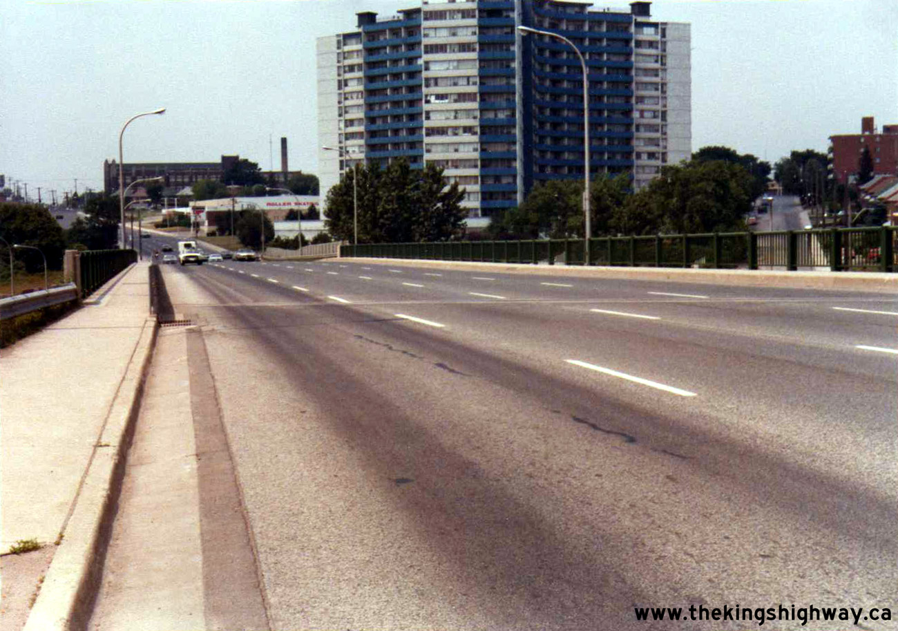
Left - Mohawk Road Overpass on Hwy 403 in Ancaster, facing north. Photo taken on November 30, 1977. (Photo courtesy of Ontario Ministry of Transportation - © King's Printer for Ontario, 2012) Right - Facing west across the westbound Hwy 2 & Hwy 8 (King Street) Overpass on Hwy 403 in Downtown Hamilton. See an Enlarged Photo Here. Photo taken in July 1979. (Photo courtesy of Ontario Ministry of Transportation - © King's Printer for Ontario, 2014) 

Left - Facing west across the eastbound Hwy 2 & Hwy 8 (Main Street) Overpass on Hwy 403 in Downtown Hamilton. See an
Enlarged Photo Here. Photo taken in July 1979. (Photo courtesy of Ontario Ministry of Transportation - © King's Printer for Ontario, 2014) Right - Eastbound-to-northbound flyover (Ramp "Q") on Hwy 403 at the Hwy 6 Interchange between Hamilton and Burlington. See an Enlarged Photo Here. Photo taken in August 1979. (Photo courtesy of Ontario Ministry of Transportation - © King's Printer for Ontario, 2012) 

Left - Southbound-to-eastbound flyover (Ramp "R") on Hwy 403 at the Hwy 6 Interchange between Hamilton and Burlington. See an
Enlarged Photo Here. Photo taken in August 1979. (Photo courtesy of Ontario Ministry of Transportation - © King's Printer for Ontario, 2014) Right - Passing through the Hwy 6 Interchange on westbound Hwy 403 between Hamilton and Burlington. See an Enlarged Photo Here. Photo taken in August 1979. (Photo courtesy of Ontario Ministry of Transportation - © King's Printer for Ontario, 2012) 

Left - Facing east along Hwy 403 from the Hwy 6 Interchange between Hamilton and Burlington. See an
Enlarged Photo Here. Photo taken in August 1979. (Photo courtesy of Ontario Ministry of Transportation - © King's Printer for Ontario, 2014) Right - Old Hwy 6 (Plains Road) Overpass on Hwy 403, facing south towards the Hwy 2 Junction. See an Enlarged Photo Here. Photo taken in August 1979. (Photo courtesy of Ontario Ministry of Transportation - © King's Printer for Ontario, 2014)
Continue on to King's Highway 403 Historical Photos: 1980 to 1989
|
|---|
Links to Adjacent King's Highway Photograph Pages:
Back to King's Highway 402 Photos /
King's Highway 403 History /
On to King's Highway 404 Photos
Ontario Highway History - Main Menu / Back to List of Highways Website contents, photos & text © 2002-2026, Cameron
Bevers (Webmaster) - All Rights Reserved / Contact Me
|
|---|