
| 
| |
|
|
This page contains historical photos of Ontario's King's Highway 404 dating from 1975 to 1979. All photographs displayed on
this page were taken by the Ontario Ministry of Transportation, unless specifically noted otherwise. Historical photographs are arranged in approximate chronological
order. Click on any thumbnail to see a larger image!
Please note that all photographs displayed on this
website are protected by copyright. These photographs must not be reproduced, published,
electronically stored or copied, distributed, or posted onto other websites without
my written permission. If you want to use photos from this website, please
email me first for permission. Thank-you!
|
|---|
|
Page 1: Historical King's Highway 404 Photographs (1975-1979)


Left - Facing south towards Structure #11 at the Don Valley Parkway Interchange on Hwy 401 in Toronto in 1975. This structure carries traffic from the
Southbound Don Valley Parkway (today's Hwy 404) to the Eastbound Hwy 401 Collector Lanes. The Southbound through lanes on the Don Valley Parkway are carried by
Structure #2, which can be seen at left. Note the pre-Metric 20 m.p.h. advisory speed sign at right. See an
Enlarged Photo Here. Photo taken on October 27, 1975. (Photo courtesy of Ontario Ministry of Transportation - © King's Printer for Ontario, 2013) Right - Structure #11 at the Don Valley Parkway Interchange on Hwy 401 in Toronto, facing south (October 27, 1975) (Photo courtesy of Ontario Ministry of Transportation - © King's Printer for Ontario, 2013) 

Left - Facing south across Structure #12 at the Don Valley Parkway Interchange on Hwy 401 in Toronto in 1975. This structure carries traffic from the
Northbound Don Valley Parkway to the Westbound Hwy 401 Collector Lanes. The Northbound through lanes on the Don Valley Parkway are carried by Structure #3, which
can be seen at right. Photo taken on October 27, 1975. (Photo courtesy of Ontario Ministry of Transportation - © King's Printer for Ontario, 2013) Right - Don Valley Parkway, facing south from the Hwy 401 Interchange in Toronto in 1975. The absolute absence of traffic on the highway may come as a surprise to anyone who is familiar with this congested interchange today. At right, a single car can be seen entering the Northbound Don Valley Parkway (today's Hwy 404) from Eastbound Hwy 401. At the time this photo was taken, Hwy 404 didn't exist yet. The Don Valley Parkway ended about 1/2 mile to the north at Sheppard Avenue, after which the expressway ended and turned into a rural two-lane road (Woodbine Avenue). In 1977, Hwy 404 was completed and opened to traffic up to Steeles Avenue, bringing with it the promise of new development opportunities and prosperity for the many then-sleepy rural towns and communities of York Region. See an Enlarged Photo Here. Photo taken on October 27, 1975. (Photo courtesy of Ontario Ministry of Transportation - © King's Printer for Ontario, 2013) 

Left - Facing south across Structure #9 at the Hwy 401 & Don Valley Parkway Interchange in Toronto. This structure carries traffic from the Southbound Don
Valley Parkway (today's Hwy 404) to the Westbound Hwy 401 Express Lanes. Photo taken in November, 1975. (Photo courtesy of Ontario Ministry of Transportation - © King's Printer for Ontario, 2013) Right - Structure #9 at the Hwy 401 & Don Valley Parkway Interchange in Toronto (November, 1975) (Photo courtesy of Ontario Ministry of Transportation - © King's Printer for Ontario, 2013) 

Left - Facing south along the Don Valley Parkway (today's Hwy 404) towards the Hwy 401 Interchange in Toronto in 1975. See an
Enlarged Photo Here. Photo taken on December 11, 1975. (Photo courtesy of Ontario Ministry of Transportation - © King's Printer for Ontario, 2013) Right - Structure #5 at the Hwy 401 & Don Valley Parkway Interchange in Toronto (December 11, 1975) (Photo courtesy of Ontario Ministry of Transportation - © King's Printer for Ontario, 2013) 
Above - Fluorescent-tube lighting system on the Don Valley Parkway at the Hwy 401 Interchange in Toronto in 1975. This stylish illumination system was used on
many Metro Toronto expressways up until the 1980s and 1990s, when they were phased out and replaced by a high-pressure sodium illumination system. Today, the Hwy 404
& Don Valley Parkway Interchange on Hwy 401 is illuminated using high-mast luminaires. Photo taken on December 11, 1975. (Photo courtesy of Ontario Ministry of Transportation - © King's Printer for Ontario, 2013) 
Above - Facing east towards Structure #5 at the Hwy 404 & Don Valley Parkway Interchange in Toronto in 1976. A subcollector lane was added below this
structure in 1999 in order to separate longer-distance traffic heading north towards Newmarket on Hwy 404 from local traffic heading to the adjacent Sheppard Avenue
Interchange on Hwy 404. The subcollector lane was added by excavating the embankment at right and constructing a retaining wall system. Prior to 1999, the proximity
of the Sheppard Avenue Interchange on Hwy 404 created severe weaving problems between the exit ramp and the Hwy 404 & Don Valley Parkway Interchange. Traffic
entering Northbound Hwy 404 from Eastbound Hwy 401 was forced to slow down while local traffic wishing to exit at Sheppard Avenue attempted to change lanes within the
constrained amount of space between the two interchanges. Photo taken on April 5, 1976. (Photo courtesy of Ontario Ministry of Transportation - © King's Printer for Ontario, 2013) 

Left - Overhead signs mounted to the Hwy 404 & Don Valley Parkway Overpass on Hwy 401 in Toronto (September 11, 1977) (Photo courtesy of Ontario Ministry of Transportation - © King's Printer for Ontario, 2013) Right - Structure #6 at the Hwy 404 & Don Valley Parkway Interchange on Hwy 401 in Toronto. This structure carries traffic from the Northbound Don Valley Parkway to the Eastbound Hwy 401 Express and Collector Lanes. Photo taken on September 11, 1977. (Photo courtesy of Ontario Ministry of Transportation - © King's Printer for Ontario, 2013) 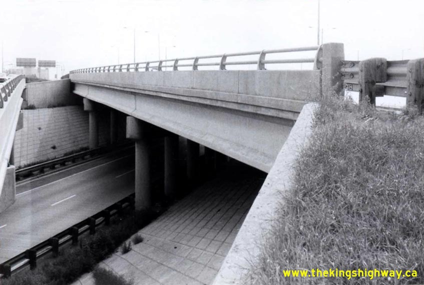

Left - Structure #8 at the Hwy 404 & Don Valley Parkway Interchange on Hwy 401 in Toronto (September 11, 1977) (Photo courtesy of Ontario Ministry of Transportation - © King's Printer for Ontario, 2013) Right - Facing north across Structure #6 at the Hwy 404 & Don Valley Parkway Interchange on Hwy 401 in Toronto. This structure carries traffic from the Northbound Don Valley Parkway to the Eastbound Hwy 401 Express and Collector Lanes. See an Enlarged Photo Here. Photo taken on September 11, 1977. (Photo courtesy of Ontario Ministry of Transportation - © King's Printer for Ontario, 2013) 
Above - Facing north along Hwy 404 towards the freeway's original northern terminus at Steeles Avenue in Toronto (June 26, 1978) (Photo courtesy of Ontario Ministry of Transportation - © King's Printer for Ontario, 2010) 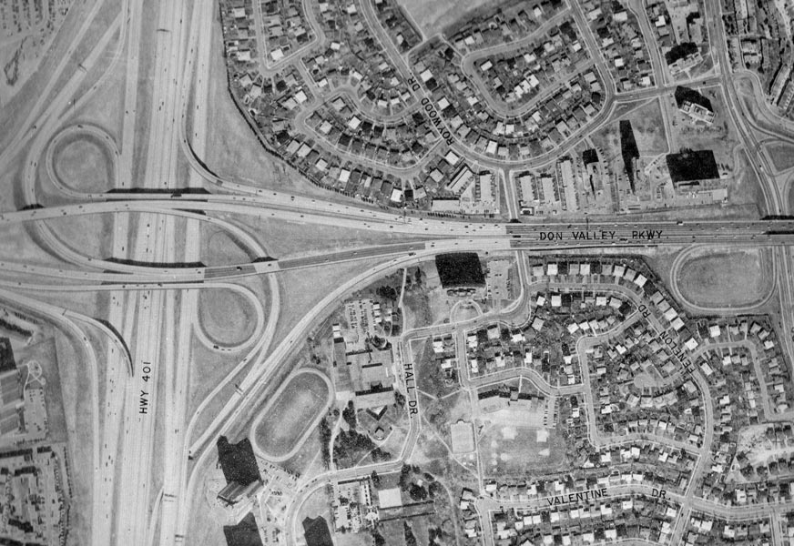
Above - Aerial view of the Hwy 401 & Hwy 404/Don Valley Parkway Interchange in Toronto (1978) (Photo courtesy of Ontario Ministry of Transportation - © King's Printer for Ontario, 2009) 
Above - Aerial view of the Hwy 404 & Sheppard Avenue Interchange in Toronto in 1978. The above photo shows the original interchange layout,
before the ramps on the western side of the highway were reconfigured. At the time this photo was taken, Fairview Mall Drive had its own set of ramps to
and from Southbound Hwy 404. The ramps to Fairview Mall Drive were closed in the 1980s when the ramps to Sheppard Avenue were realigned. The ramp
modifications were carried out in order to provide more direct access between Hwy 404 and Fairview Mall. (Photo courtesy of Ontario Ministry of Transportation - © King's Printer for Ontario, 2009) 
Above - Aerial view of Hwy 404 between Van Horne Avenue and the Finch Avenue Interchange in Toronto (1978) (Photo courtesy of Ontario Ministry of Transportation - © King's Printer for Ontario, 2009) 
Above - Aerial view of the Hwy 404 & Woodbine Avenue Interchange in Toronto in 1978. The above photo shows the original northern terminus of
Hwy 404, before the highway was extended north towards Newmarket. Originally, all northbound traffic was forced to exit the freeway and use Woodbine Avenue
to continue north. Southbound Woodbine Avenue traffic accessed the freeway via a flyover located immediately south of Steeles Avenue. The future Steeles
Avenue Interchange can be seen under construction at left. (Photo courtesy of Ontario Ministry of Transportation - © King's Printer for Ontario, 2009) 
Above - Aerial view of Hwy 404 during the highway's construction between Steeles Avenue and the CN Railway Overpass (1978) (Photo courtesy of Ontario Ministry of Transportation - © King's Printer for Ontario, 2009) 
Above - Aerial view of Hwy 404 during the highway's construction between the CN Railway Overpass and the proposed site of Hwy 407 (1978) (Photo courtesy of Ontario Ministry of Transportation - © King's Printer for Ontario, 2009) 
Above - Aerial view of the Hwy 404 & Hwy 7 Interchange near Richmond Hill in 1978. The above photo shows the interchange while it was still under
construction. This photo is of particular interest, because it shows the rural setting of this interchange before urban sprawl encroached into this area in
the 1980s. Compare this photo with the 1988 photo on the following page that was taken a decade later. (Photo courtesy of Ontario Ministry of Transportation - © King's Printer for Ontario, 2009)
Continue on to King's Highway 404 Historical Photos: 1980-1989
|
|---|
Links to Adjacent King's Highway Photograph Pages:
Back to King's Highway 403 Photos /
King's Highway 404 History /
On to King's Highway 405 Photos
Ontario Highway History - Main Menu / Back to List of Highways Website contents, photos & text © 2002-2026, Cameron
Bevers (Webmaster) - All Rights Reserved / Contact Me
|
|---|