
| 
|  |
|
|
This page contains historical and present day photos of Ontario's King's Highway 41B. All photographs displayed on this page
were taken by the Webmaster (Cameron Bevers), unless specifically noted otherwise. Historical photographs are arranged in approximate chronological order, while
present day photographs (Year 2000 to date) are arranged by location from south to north. Click on any thumbnail to see a larger image!
Please note that all photographs displayed on this
website are protected by copyright. These photographs must not be reproduced, published,
electronically stored or copied, distributed, or posted onto other websites without
my written permission. If you want to use photos from this website, please
email me first for permission. Thank-you!
|
|---|
|
Present Day King's Highway 41B Photographs
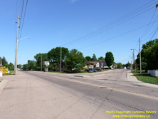
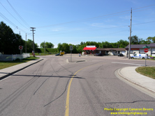
Left - Junction of Former Hwy 41 and Former Hwy 41B at the intersection of Boundary Road and Eganville Road in Pembroke. When Hwy 41 was first extended
northerly to Pembroke in 1957, most highway traffic entered town via Eganville Road at right. Eganville Road and adjacent Christie Street began to be signed as a
Business Route (Hwy 41B) in the early 1960s. See an Enlarged Photo Here. (Photograph taken on June 4, 2010 - © Cameron Bevers) Right - Former southern terminus of Hwy 41B at the intersection of Eganville Road and Boundary Road (Old Hwy 41) in Pembroke. Note the vintage "Keep Right" sign on the traffic island. Today, these signs feature a graphical representation of proper traffic flow direction adjacent to the traffic island, rather than the textual message instructing motorists to "Keep Right". See an Enlarged Photo Here. (Photograph taken on June 4, 2010 - © Cameron Bevers) 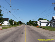
Left - View of Boundary Road (Old Hwy 41) facing north near Eganville Road (Former Hwy 41B) in Pembroke. An old Department of Highways of Ontario (DHO)
luminaire from the early 1960s can be seen attached to the hydro pole at left. Typically, luminaire installations from this era were mercury vapour units rather than
the high-pressure sodium units more commonly used in later decades. While the Hwy 41B spur into Pembroke was designated as a Municipal Connecting Link and was thus
not under provincial jurisdiction, the main route of Hwy 41 via Boundary Road was owned by the province right up until 1987. See an
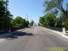
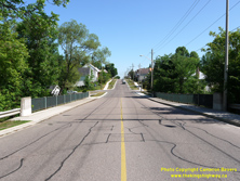
Enlarged Photo Here. (Photograph taken on June 4, 2010 - © Cameron Bevers) Right - Facing south along Christie Street (Former Hwy 41B) in Pembroke at the Indian River Bridge (Site #29-151). See an Enlarged Photo Here. (Photograph taken on June 4, 2010 - © Cameron Bevers) 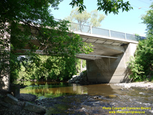
Left - Side view of the Indian River Bridge on Christie Street (Former Hwy 41B). This single-span concrete rigid frame structure was completed in 1957. See an
Enlarged Photo Here. (Photograph taken on June 4, 2010 - © Cameron Bevers) Right - Facing north along Christie Street (Former Hwy 41B) in Pembroke at the Indian River Bridge. See an Enlarged Photo Here. (Photograph taken on June 4, 2010 - © Cameron Bevers) 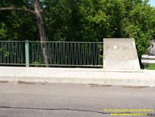
Above - Steel handrail design on the Indian River Bridge on Former Hwy 41B in Pembroke. This handrail design was used on some municipal bridges dating from the
late 1950s, but is not known to exist on any provincial highway bridges. The route of Hwy 41B leading into Pembroke was part of a Municipal Connecting Link route
owned by the Town of Pembroke. See an Enlarged Photo Here. (Photograph taken on June 4, 2010 - © Cameron Bevers)
More King's Highway 41B Photographs Coming Soon!
|
|---|
Links to Adjacent King's Highway Photograph Pages:
Back to King's Highway 41 Photos /
King's Highway 41B History /
On to King's Highway 42 Photos
Ontario Highway History - Main Menu / Back to List of Highways Website contents, photos & text © 2002-2025, Cameron
Bevers (Webmaster) - All Rights Reserved / Contact Me |
|---|