
| 
| |
|
|
This page contains historical and present day photos of Ontario's King's Highway 42. All photographs displayed on this page
were taken by the Webmaster (Cameron Bevers), unless specifically noted otherwise. Historical photographs are arranged in approximate chronological order, while
present day photographs (Year 2000 to date) are arranged by location from west to east. Click on any thumbnail to see a larger image!
Please note that all photographs displayed on this
website are protected by copyright. These photographs must not be reproduced, published,
electronically stored or copied, distributed, or posted onto other websites without
my written permission. If you want to use photos from this website, please
email me first for permission. Thank-you!
|
|---|
|
Historical King's Highway 42 Photographs

Above - Exterior view of the Regent Theatre on King Street (Hwy 2) at Perth Street in Downtown Brockville in 1947. Although the signs are unfortunately facing
the other way, the backs of three King's Highway shields (Hwy 2, Hwy 29 & Hwy 42) mark the former junction of these highways at the intersection of King Street
and Perth Street. Several years after this photo was taken, Hwy 29 & Hwy 42 were both rerouted through Brockville so that these highways passed through Courthouse
Square rather than follow Perth Street north out of the city centre. See an Enlarged Photo Here.
Photo taken in 1947. (Photo © Archives of Ontario - Series RG-56-11, Photo #I-0027263) 
Above - Construction of the Newboro Bridge over the Rideau Canal on Hwy 42. Photo taken on June 25, 1952. (Photo courtesy of Ontario Ministry of Transportation - © King's Printer for Ontario, 1952) 
Above - Circa 1960 postcard view of King Street (Hwy 2) in Downtown Brockville, facing east at Court House Avenue (Hwy 29 & Hwy 42). See an
Enlarged Photo Here. (Photo courtesy of Rideau Air Photos) 
Above - View of the Brockville Bypass (Hwy 401) facing west towards Kingston from the Hwy 29 & Hwy 42 (Stewart Boulevard) Interchange in Brockville in
1960. This photo was taken shortly after the north (westbound) carriageway of Hwy 401 was completed and opened to traffic on September 16, 1960. Previously, both
directions of traffic used the south (eastbound) carriageway. See an Enlarged Photo Here.
Photo taken in 1960. (Photo courtesy of Ontario Ministry of Transportation - © King's Printer for Ontario, 1960) 
Above - Circa 1965 postcard view of King Street (Hwy 2) in Downtown Brockville, facing east towards the Hwy 29 & Hwy 42 Junction. See an
Enlarged Photo Here. Photo taken circa 1965. (Photo courtesy of the Gananoque Reporter) 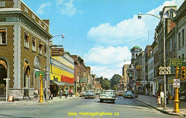
Above - Reconstructed section of Hwy 42 through Delta in 1978. See an
Enlarged Photo Here. (Photo courtesy of Ontario Ministry of Transportation - © King's Printer for Ontario, 1978) |
|---|
|
Present Day King's Highway 42 Photographs


Left - Western terminus of Hwy 42 at the Leeds & Grenville Road 10 Junction in Westport, facing west. (Photograph taken on August 3, 2008 - © Cameron Bevers) Right - Fingerboard sign marking the Leeds & Grenville Road 10 Junction at the end of Hwy 42 in Westport. (Photograph taken on August 3, 2008 - © Cameron Bevers) 

Left - Approaching the western terminus of Hwy 42 on Leeds & Grenville Road 10 (Rideau Street) in Westport. County Road 10 provides a fairly direct
route for traffic between Ottawa and Kingston. As a result, most of the long distance through traffic passing through Westport actually uses County Road 10
as opposed to Hwy 42. County Road 10 traffic turns left at this intersection and follows Hwy 42 for a short distance through Westport, before resuming its
route southwesterly towards Kingston. (Photograph taken on August 3, 2008 - © Cameron Bevers) Right - Fingerboard signs at the junction of Hwy 42 and Leeds & Grenville Road 10 in Westport. From this junction, traffic can also access the county roads leading to Hwy 7 at Maberly and Hwy 38 at Godfrey. (Photograph taken on August 3, 2008 - © Cameron Bevers) 

Left - Facing east along Hwy 42 from the highway's western terminus at the Leeds & Grenville Road 10 Junction in Westport. (Photograph taken on August 3, 2008 - © Cameron Bevers) Right - Rideau Canal Bridge on Hwy 42 at Newboro, facing west towards Westport. Structure completed in 1952. (Photograph taken on August 3, 2008 - © Cameron Bevers) 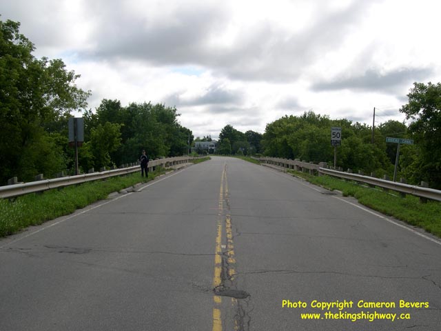

Left - Rideau Canal Bridge on Drummond Street (Hwy 42) at Newboro, facing east towards Crosby. (Photograph taken on August 3, 2008 - © Cameron Bevers) Right - Rideau Canal Bridge on Hwy 42. This style of concrete beam railing was used on many Ontario highway bridges built between 1944 and 1962. (Photograph taken on August 3, 2008 - © Cameron Bevers) 

Left - Rideau Canal as seen from the Drummond Street Bridge at Newboro. The Newboro Bridge on Hwy 42 was completed in 1952. It replaced an old steel
structure which existed a short distance to the north of the current bridge. The concrete abutment of the old structure is still visible at the centre of
this photo. (Photograph taken on August 3, 2008 - © Cameron Bevers) Right - Facing west along Main Street in Newboro. This was the former alignment of Hwy 42 leading to the old Rideau Canal Bridge site. (Photograph taken on August 3, 2008 - © Cameron Bevers) 

Left - This quiet residential street in Newboro was not always this way. Main Street was the former alignment of Hwy 42 approaching the Rideau Canal
Bridge. The superelevated curve in the background was obviously designed to move fast through traffic. Today, it is a dead-end street. (Photograph taken on August 3, 2008 - © Cameron Bevers) Right - Facing east along Hwy 42 in Forfar. A channelized right turn was constructed at this intersection to allow eastbound trucks to make the turn to continue on Hwy 42. (Photograph taken on August 3, 2008 - © Cameron Bevers) 

Left - Signs at the main intersection in Forfar, facing east. While Hwy 42 turns right here, a cut-off route to Hwy 15 is signed along Young's Hill
Road. It is very unusual for traffic between two provincial highways to be directed to use a township road. (Photograph taken on August 3, 2008 - © Cameron Bevers) Right - Approaching the channelized right turn on Hwy 42 in Forfar. Given the amount of land required to develop this right turn channelization within this small community, it is rather surprising that Forfar was not bypassed entirely. (Photograph taken on August 3, 2008 - © Cameron Bevers) 

Left - Oversized Hwy 42 route marker in Forfar, directing eastbound traffic to turn right. (Photograph taken on August 3, 2008 - © Cameron Bevers) Right - Facing west along Hwy 42 towards the main intersection in Forfar. (Photograph taken on August 3, 2008 - © Cameron Bevers) 

Left - Signs at the main intersection in Forfar, facing west. At this intersection, Hwy 42 turns left and proceeds out to Hwy 15 at Crosby. However,
traffic bound for Hwy 15 North will find that the signed cut-off route via Young's Hill Road is several kilometres shorter. (Photograph taken on August 3, 2008 - © Cameron Bevers) Right - View of the channelized right turn on Hwy 42 in Forfar. Before this geometric improvement was made, it would have been nearly impossible for a long truck to turn right at this intersection. (Photograph taken on August 3, 2008 - © Cameron Bevers) 
Above - Green guide sign for Hwy 29 at the end of Hwy 42 at Forthton. See an
Enlarged Photo Here. (Photograph taken on May 21, 2005 - © Cameron Bevers)
More King's Highway 42 Photographs Coming Soon!
|
|---|
Links to Adjacent King's Highway Photograph Pages:
Back to King's Highway 41 Photos /
King's Highway 42 History /
On to King's Highway 43 Photos
Ontario Highway History - Main Menu / Back to List of Highways Website contents, photos & text © 2002-2026, Cameron
Bevers (Webmaster) - All Rights Reserved / Contact Me
|
|---|