
| 
|  |
|
|
This page contains historical and present day photos of Ontario's King's Highway 50. All photographs displayed on this page
were taken by the Webmaster (Cameron Bevers), unless specifically noted otherwise. Historical photographs are arranged in approximate chronological order, while
present day photographs (Year 2000 to date) are arranged by location from south to north. Click on any thumbnail to see a larger image!
Please note that all photographs displayed on this
website are protected by copyright. These photographs must not be reproduced, published,
electronically stored or copied, distributed, or posted onto other websites without
my written permission. If you want to use photos from this website, please
email me first for permission. Thank-you!
|
|---|
|
Historical King's Highway 50 Photographs
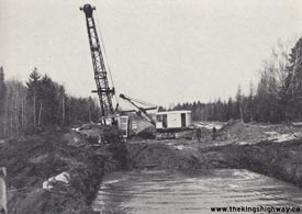
Above - Excavating muskeg along a reconstructed section of Hwy 50 north of Palgrave. Photo taken on March 8, 1949. (Photo courtesy of Ontario Ministry of Transportation - © King's Printer for Ontario, 1949) 

Left - Aerial view of Albion Road (Hwy 50) at the Hwy 27 Junction in 1954, facing southeast. Compare the 1954 photo at left to the 1969 photo at right, showing
the same intersection amidst the rapidly developing area of Rexdale. Photo taken in September, 1954. See an
Enlarged Photo Here. (Photo courtesy of Lockwood Survey Corporation) Right - Aerial view of Albion Road (Hwy 50) at the Hwy 27 Junction in 1969, facing southeast. Photo taken in April, 1969. See an Enlarged Photo Here. (Photo courtesy of Lockwood Survey Corporation) 
Above - New Palgrave Pond Bridge on Hwy 50 north of Palgrave (1962) (Photo courtesy of Ontario Ministry of Transportation - © King's Printer for Ontario, 1962) 
Above - Aerial view of the Hwy 7 & Hwy 50 Junction at Sunset Corners in 1967, facing southeast towards Toronto. This great photo shows the pre-construction
conditions at this major highway junction between Woodbridge and Brampton. Shortly after this photo was taken, Hwy 7 was expanded to four lanes and the intersection
was rebuilt with right-turn channels on all approaches. Most notable here are the four service stations on each corner. A Fina station occupied the northwest corner,
a British-American (B-A) station occupied the northeast corner, an Esso station occupied the southeast corner and a Texaco station occupied the southwest corner. Out
of these four brands of gasoline retailers, only Esso is still in operation in 2016. All four service stations at the highway junction were demolished to make way for
the widened Hwy 7 in 1971. The only surviving landmarks in this photo are the historic buildings of Sunny Maple Farms in the background, whose barn with the rooftop
sign still remains in place to this day. See an Enlarged Photo here. Photo taken in 1967. (Photo courtesy of Ontario Ministry of Transportation - © King's Printer for Ontario, 2016) 
Above - Aerial view of Hwy 7 between the Hwy 50 Junction and Hwy 427 Interchange near Woodbridge in 1991. The Hwy 427 Interchange was still under
construction at the time this photo was taken. During the construction of the Hwy 427 Interchange, Hwy 7 was diverted to the north onto a temporary
alignment until the grade separation was completed. Although the new structure was finished by the time this photo was taken, traces of the temporary
Hwy 7 diversion are still visible in this photo. See an Enlarged Photo here. (Photo courtesy of Ontario Ministry of Transportation - © King's Printer for Ontario, 2009) 
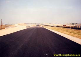
Left - New northbound lanes of Hwy 427 at the Hwy 50 (Albion Road) Underpass in Toronto. See an
Enlarged Photo here. Photo taken on August 27, 1991. (Photo courtesy of Ontario Ministry of Transportation - © King's Printer for Ontario, 2014) Right - Unopened southbound lanes of Hwy 427 at the Hwy 50 (Albion Road) Underpass in Toronto in 1991, facing north towards the Hwy 407 Interchange. The graded but unpaved ramp leading from the completed Hwy 407 West to Hwy 427 South Flyover can be seen at left. See an Enlarged Photo here. Photo taken on August 27, 1991. (Photo courtesy of Ontario Ministry of Transportation - © King's Printer for Ontario, 2014) |
|---|
|
Present Day King's Highway 50 Photographs


Left - Facing north along Hwy 50 towards Old Church Road at Cedar Mills. Although not visible in this photo, the Humber River passes below Hwy 50 twice before
the highway reaches the traffic signals at the bottom of the hill. See an Enlarged Photo here. (Photograph taken on September 25, 2016 - © Cameron Bevers) Right - Western side of the Cedar Mills Culvert over the Humber River on Hwy 50. This concrete barrel arch structure was completed in 1941. See an Enlarged Photo here. (Photograph taken on September 25, 2016 - © Cameron Bevers) 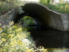
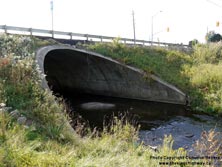
Left - Eastern side of the Cedar Mills Culvert over the Humber River on Hwy 50. The eastern side of the Humber River Culvert was extended slightly in 1965 to
make way for a widened highway across the structure. See an Enlarged Photo here. (Photograph taken on September 25, 2016 - © Cameron Bevers) Right - North Cedar Mills Culvert over the Humber River on Hwy 50. This concrete barrel arch structure was completed in 1965. See an Enlarged Photo here. (Photograph taken on September 25, 2016 - © Cameron Bevers) 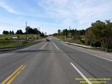

Left - Facing north along Hwy 50 approaching Old Church Road between Bolton and Palgrave. The North Cedar Mills Culvert passes below Hwy 50 at this point. See
an Enlarged Photo here. (Photograph taken on September 25, 2016 - © Cameron Bevers) Right - North Cedar Mills Culvert over the Humber River on Hwy 50, facing east. See an Enlarged Photo here. (Photograph taken on September 25, 2016 - © Cameron Bevers) 

Left - Canadian Pacific (CP) Railway Subway near Palgrave, looking north along Hwy 50. Structure completed in 1965. See an
Enlarged Photo here. (Photograph taken on February 28, 2004 - © Cameron Bevers) Right - Looking south along a former Hwy 50 alignment, south of the Palgrave Subway. This section of Hwy 50 was bypassed in 1949, when a new Hwy 50 alignment was built to eliminate two steep grades and a badly skewed at-grade railway crossing. Although the railway crossing itself remained at-grade until the subway was built in 1965, the revised Hwy 50 alignment was a substantial improvement over the original 1937 highway alignment depicted here. See an Enlarged Photo here. (Photograph taken on February 28, 2004 - © Cameron Bevers) 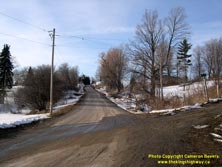
Left - Looking north along a former bypassed alignment of Hwy 50, south of the Palgrave Subway. It may seem hard to believe, but this narrow road carried
Hwy 50 traffic up until 1949, when it was bypassed by a revised alignment on an improved grade. See an
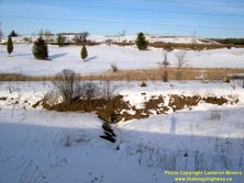
Enlarged Photo here. (Photograph taken on February 28, 2004 - © Cameron Bevers) Right - This embankment and old culvert indicate an abandoned alignment of Hwy 50 near Palgrave. See an Enlarged Photo here. (Photograph taken on February 28, 2004 - © Cameron Bevers) 
Left - Unusual squared concrete bents supporting the Palgrave Pond Bridge on Hwy 50. This three-span continuous concrete slab structure was completed in 1961.
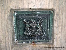
See an Enlarged Photo here. (Photograph taken on February 28, 2004 - © Cameron Bevers) Right - Thoughtful preservation: A bronze Department of Highways of Ontario (DHO) bridge plaque was reinstalled on this rehabilitated highway bridge on Hwy 50 north of Palgrave. Bronze plaques such as this one were set into the handrails of many DHO-built bridges constructed from the late 1930s until the early 1960s. See an Enlarged Photo here. (Photograph taken on February 28, 2004 - © Cameron Bevers) 
Above - Humber River Bridge on Hwy 50 north of Palgrave. Structure completed in 1953. See an
Enlarged Photo here. (Photograph taken on February 28, 2004 - © Cameron Bevers) 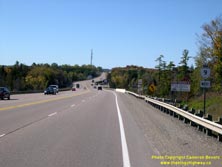

Left - Facing west along Hwy 9 from the Hwy 50 Junction between Schomberg and Orangeville. See an
Enlarged Photo here. (Photograph taken on October 10, 2008 - © Cameron Bevers) Right - Facing west along Hwy 9 towards the Hwy 50 Junction between Schomberg and Orangeville. The Mono Mills Grade can be seen in the distance. See an Enlarged Photo here. (Photograph taken on October 10, 2008 - © Cameron Bevers) 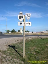
Above - Junction assembly at the Hwy 89 and Simcoe Road 50 (Former Hwy 50) Junction near Alliston. See an
Enlarged Photo here. (Photograph taken on September 8, 2007 - © Cameron Bevers)
More King's Highway 50 Photographs Coming Soon!
|
|---|
Links to Adjacent King's Highway Photograph Pages:
Back to King's Highway 49 Photos /
King's Highway 50 History /
On to King's Highway 51 (#1) Photos
Ontario Highway History - Main Menu / Back to List of Highways Website contents, photos & text © 2002-2026, Cameron
Bevers (Webmaster) - All Rights Reserved / Contact Me
|
|---|