
| 
| |
|
|
This page contains historical and present day photos of Ontario's King's Highway 52. All photographs displayed on this page
were taken by the Webmaster (Cameron Bevers), unless specifically noted otherwise. Historical photographs are arranged in approximate chronological order, while
present day photographs (Year 2000 to date) are arranged by location from south to north. Click on any thumbnail to see a larger image!
Please note that all photographs displayed on this
website are protected by copyright. These photographs must not be reproduced, published,
electronically stored or copied, distributed, or posted onto other websites without
my written permission. If you want to use photos from this website, please
email me first for permission. Thank-you!
|
|---|
|
Historical King's Highway 52 Photographs

Above - Aerial view of Hwy 2 & Hwy 53 at the Hwy 52 Junction west of Ancaster. See an
Enlarged Photo Here. Photo taken in 1974. (Photo courtesy of Ontario Ministry of Transportation - © King's Printer for Ontario, 2016) |
|---|
|
Present Day King's Highway 52 Photographs


Left - Former Hwy 52 alignment south of Copetown, facing north. See an
Enlarged Photo Here. (Photograph taken on September 15, 2005 - © Cameron Bevers) Right - A portion of the former Hwy 52 alignment has been closed to traffic. See an Enlarged Photo Here. (Photograph taken on September 15, 2005 - © Cameron Bevers) 

Left - Another former Hwy 52 alignment south of Copetown. See an
Enlarged Photo Here. (Photograph taken on September 15, 2005 - © Cameron Bevers) Right - This long-abandoned Hwy 52 alignment near Copetown now serves as a private driveway. Note the old curved pavement which leads into the grass. This portion of Hwy 52 was bypassed because of a dangerous level railway crossing nearby which had poor visibility. See an Enlarged Photo Here. (Photograph taken on September 15, 2005 - © Cameron Bevers) 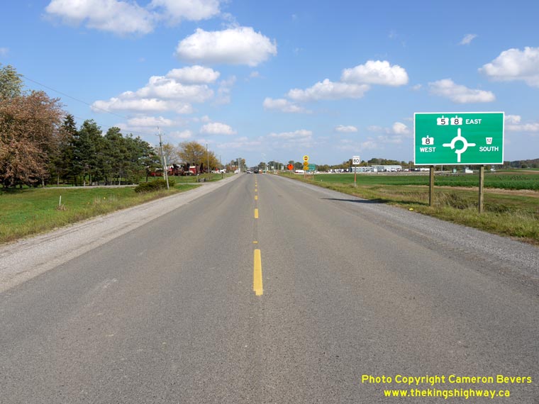

Left - Facing east along Hwy 5 approaching the Peters Corners Roundabout at the Junction of Hwy 8 & Hwy 52 near Dundas. (Photograph taken on October 4, 2012 - © Cameron Bevers) Right - Close-up of the guide sign on Eastbound Hwy 5 at the Peters Corners Roundabout. As a result of the new roundabout and corresponding highway realignments, the route of Hwy 8 was extended easterly for a few hundred metres, concurrently with Hwy 5. This was done to provide continuity in the route of Hwy 8 between Cambridge and the City of Hamilton-owned leg of Hwy 8 East leading to Dundas. (Photograph taken on October 4, 2012 - © Cameron Bevers) 

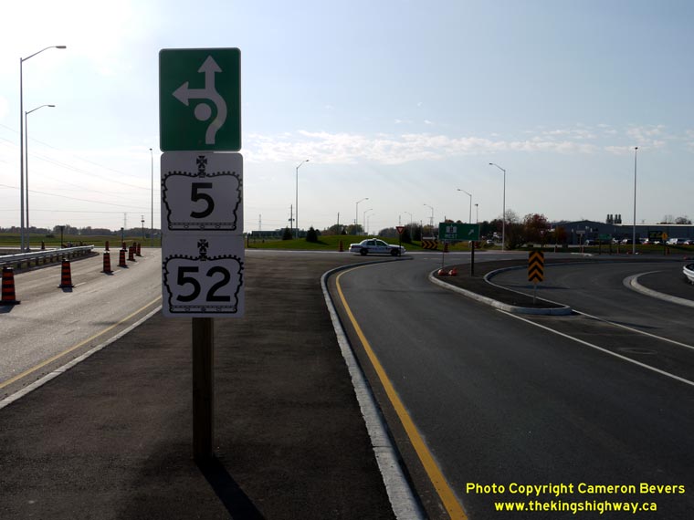
Left - Entering the Peters Corners Roundabout on Eastbound Hwy 5. To follow Hwy 52 South to Copetown, motorists must stay in the right lane, while motorists
wishing to follow Hwy 8 West to Cambridge must stay in the left lane. Motorists heading to Dundas or Waterdown on Hwy 5 East & Hwy 8 East can utilize either
approach lane. Traffic entering the roundabout must first yield to circulating traffic in both lanes of the roundabout before proceeding. (Photograph taken on October 17, 2012 - © Cameron Bevers) Right - Facing west along Hwy 5 towards Paris from the central island of the new Peters Corners Roundabout. The roundabout was officially opened to traffic only minutes before this photo was taken on October 4, 2012. The new Peters Corners Roundabout is actually the Ministry of Transportation's third modern roundabout constructed on a provincial highway, but it is the first one to feature multiple entry lanes. See an Enlarged Photo Here. (Photograph taken on October 4, 2012 - © Cameron Bevers) 

Left - The circulatory roadway at the Peters Corners Roundabout on Hwy 5 at Hwy 8 & Hwy 52 has been striped with two circulating lanes. Some North American
jurisdictions paint circulatory road zone markings within the roundabout, while others do not. (Photograph taken on October 17, 2012 - © Cameron Bevers) Right - Entering the Peters Corners Roundabout on Northbound Hwy 52. To follow Hwy 5 West to Paris, motorists must stay in the left lane, while motorists heading to Dundas or Waterdown on Hwy 5 East & Hwy 8 East must stay in the right lane. Motorists wishing to follow Hwy 8 West to Cambridge can utilize either approach lane. Traffic entering the roundabout must first yield to circulating traffic in both lanes of the roundabout before proceeding. See an Enlarged Photo Here. (Photograph taken on October 4, 2012 - © Cameron Bevers) 
Left - Facing south along Hwy 52 towards Copetown from the central island of the new Peters Corners Roundabout. See an
Enlarged Photo Here. (Photograph taken on October 4, 2012 - © Cameron Bevers) Right - Green-and-white lane guidance sign on Westbound Hwy 5 at the Peters Corners Roundabout. The Ministry of Transportation elected to use green and white signs for lane indications on provincially-owned roundabouts, as they are not considered to be regulatory signs. Note the temporary Hwy 5 & Hwy 52 crown signs installed below the lane guidance sign. These two crown signs are technically not correct installations, but are merely in place temporarily to guide motorists until the permanent roadway identification guide sign is installed. At the time this photo was taken, the guide sign on the Westbound Hwy 5 & Hwy 8 approach had not yet been installed. It will be placed onto a large overhead sign structure. The channelized right turn lane on this approach carries traffic to Hwy 8 West. It is marked with a standard green turn-off guide sign. See an Enlarged Photo Here. (Photograph taken on October 17, 2012 - © Cameron Bevers) 

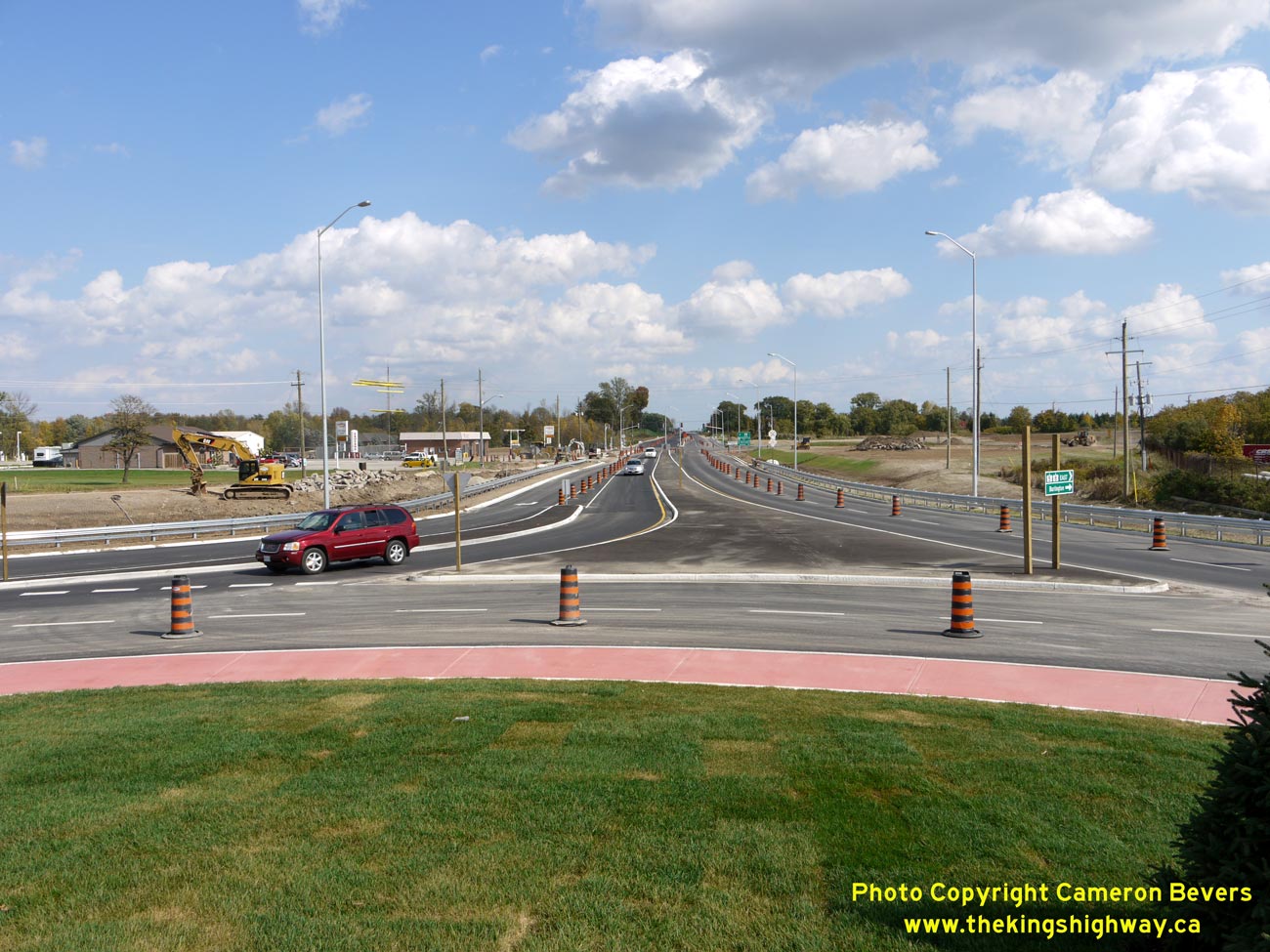
Left - Facing east along Hwy 5 & Hwy 8 towards Waterdown from the central island of the new Peters Corners Roundabout. The concurrent route of Hwy 5
& Hwy 8 ends at the new traffic signal being installed in the background. At this point Former Hwy 8 East turns right towards Dundas, while Hwy 5 continues
east towards Waterdown and Burlington. Prior to the reconstruction of Peters Corners in 2012, Hwy 8 West and Hwy 8 East were one continuous roadway, crossing Hwy 5
at a badly-skewed intersection. Immediately adjacent to that intersection were two other crossroads which experienced frequent right-angle vehicle collisions. The new
Peters Corners Roundabout effectively eliminates the risk of a right-angle collision, in addition to providing much-needed capacity improvements at this busy highway
junction. See an Enlarged Photo Here. (Photograph taken on October 4, 2012 - © Cameron Bevers) Right - Turn-off to Hwy 8 West at the Peters Corners Roundabout. For capacity reasons, the through movement on Westbound Hwy 5 (at left) only required a single lane. (Photograph taken on October 17, 2012 - © Cameron Bevers) 

Left - Facing west along Hwy 8 towards Cambridge from the central island of the new Peters Corners Roundabout. See an
Enlarged Photo Here. (Photograph taken on October 4, 2012 - © Cameron Bevers) Right - Circulating around the Peters Corners Roundabout, approaching the Hwy 5 West departure leg. The red paved area at left is a "truck apron", which was designed so that even oversized loads could be accommodated through the roundabout. Trucks carrying the giant windmill blades will be able to pass through, but will have to pass over the red truck apron in order to circulate around the central island. Truck operators carrying regular 53-foot trailers should not ordinarily have to use this truck apron. (Photograph taken on October 4, 2012 - © Cameron Bevers) 

Left - Entering the Peters Corners Roundabout on Eastbound Hwy 8. To follow Hwy 52 South to Copetown or Hwy 5 West to Paris, motorists must stay in the right
lane. Motorists heading to Dundas or Waterdown on Hwy 5 East & Hwy 8 East can utilize either approach lane. Traffic entering the roundabout must first yield to
circulating traffic inside the roundabout before proceeding. The narrow space between the approach lanes is intended to give trucks more room to manoeuvre. It will
be striped out with diagonal chevron "hatch" markings before the construction contract is completed. (Photograph taken on October 17, 2012 - © Cameron Bevers) Right - Facing north towards Guelph along Wellington Road 35 from the Old Hwy 52 Junction. It is unclear why the Department of Highways did not utilize this road to extend the route of Hwy 52 into Guelph back in the 1930s. See an Enlarged Photo Here. (Photograph taken on September 15, 2005 - © Cameron Bevers) 

Left - The old northern terminus of Hwy 52 was at the Wentworth-Wellington County Boundary. From 1938 until 1986, this quiet rural intersection
marked the end of Hwy 52. It is unclear why the Department of Highways chose this strange location to end the highway, considering that Hwy 97 (an
important east-west route prior to Hwy 401's completion in the 1960s) lies only 2 km to the south. See an
Enlarged Photo Here. (Photograph taken on September 15, 2005 - © Cameron Bevers) Right - Facing east towards Old Hwy 52 and Wellington Road 35 Junction. See an Enlarged Photo Here. (Photograph taken on September 15, 2005 - © Cameron Bevers) 
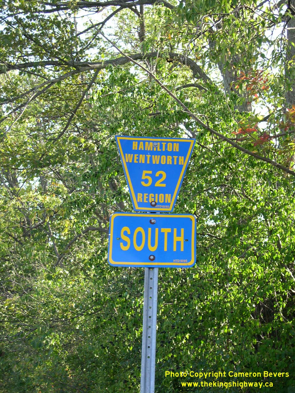
Above - Old Hamilton-Wentworth Road 52 sign. These blue municipal signs replaced the King's Highway 52 signs after the province decommissioned this
northern portion of Hwy 52. Coincidentally, these replacement signs are now obsolete as well, as the Region of Hamilton-Wentworth was amalgamated with the
City of Hamilton in 2001. The new City of Hamilton is in the process of replacing all of the old Regional Road signs with new road signs bearing the
City's new logo. See an Enlarged Photo Here. (Photograph taken on September 15, 2005 - © Cameron Bevers)
More King's Highway 52 Photographs Coming Soon!
|
|---|
Links to Adjacent King's Highway Photograph Pages:
Back to King's Highway 51 (#2) Photos /
King's Highway 52 History /
Back to King's Highway 52B Photos
Ontario Highway History - Main Menu / Back to List of Highways Website contents, photos & text © 2002-2026, Cameron
Bevers (Webmaster) - All Rights Reserved / Contact Me
|
|---|