
| 
| |
|
|
This page contains present day photos (Year 2000 to date) of Ontario's King's Highway 6, arranged by location from Manitowaning
northerly to Little Current. All photographs displayed on this page were taken by the Webmaster (Cameron Bevers), unless specifically noted otherwise. Click
on any thumbnail to see a larger image!
Please note that all photographs displayed on this
website are protected by copyright. These photographs must not be reproduced, published,
electronically stored or copied, distributed, or posted onto other websites without
my written permission. If you want to use photos from this website, please
email me first for permission. Thank-you!
|
|---|
|
Page 16: Present Day King's Highway 6 Photographs (Manitowaning to Little Current)


Left - Facing north along Hwy 6 towards Espanola from the Hwy 540 Junction in Little Current. See an
Enlarged Photo here. (Photograph taken on August 15, 2016 - © Cameron Bevers) Right - Approaching the Hwy 540 Junction in Little Current, facing south along Hwy 6. The route of Hwy 6 turns left at this intersection and continues south towards South Baymouth. Hwy 540 begins at this intersection and continues straight ahead into Little Current. See an Enlarged Photo here. (Photograph taken on August 15, 2016 - © Cameron Bevers) 

Left - Facing north along Hwy 6 towards the Hwy 540 Junction in Little Current. Hwy 6 turns right at the intersection and continues north off of Manitoulin
Island towards Espanola. At left, Hwy 540 heads into Little Current before heading west towards M'Chigeeng (West Bay), Gore Bay and Meldrum Bay. See an
Enlarged Photo here. (Photograph taken on August 15, 2016 - © Cameron Bevers) Right - Facing south along Hwy 6 towards South Baymouth from the Hwy 540 Junction in Little Current. See an Enlarged Photo here. (Photograph taken on August 15, 2016 - © Cameron Bevers) 

Left - Eastern terminus of Hwy 540 at the Hwy 6 Junction in Little Current. From here, traffic can either continue straight ahead off of Manitoulin Island
towards Espanola via Hwy 6 North, or turn right and follow Hwy 6 South towards Manitowaning and South Baymouth. See an
Enlarged Photo here. (Photograph taken on August 15, 2016 - © Cameron Bevers) Right - Facing west along Hwy 540 from the Hwy 6 Junction in Little Current. The Little Current Town Centre lies a short distance north of Hwy 540. See an Enlarged Photo here. (Photograph taken on August 15, 2016 - © Cameron Bevers) 

Left - Hwy 6 & Hwy 540 Junction assembly on northbound Hwy 6 in Little Current. See an
Enlarged Photo here. (Photograph taken on July 2, 2005 - © Cameron Bevers) Right - Junction assembly on eastbound Hwy 540 approaching the Hwy 6 Junction in Little Current. See an Enlarged Photo here. (Photograph taken on August 15, 2016 - © Cameron Bevers) 

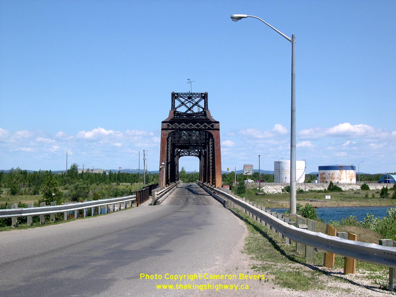
Left - Northern approach to the Little Current Swing Bridge across the North Channel on Hwy 6. See an
Enlarged Photo Here. (Photograph taken on July 2, 2005 - © Cameron Bevers) Right - The Little Current Swing Bridge is one of Ontario's most interesting highway bridges. Oddly, the bridge was never intended to serve highway traffic, as it was originally constructed as a railway bridge. The bridge was later re-decked so that it could be shared by road vehicles as well as trains. Originally, Hwy 6 traffic had to utilize a ferry service which ran across the North Channel. See an Enlarged Photo Here. (Photograph taken on July 2, 2005 - © Cameron Bevers) 

Left - Looking south through the Little Current Swing Bridge. This narrow one-lane structure is the only road access to Ontario's enormous Manitoulin Island,
and its 300 km of provincial highways. See an Enlarged Photo Here. (Photograph taken on July 2, 2005 - © Cameron Bevers) Right - Western side of the Little Current Swing Bridge as seen from Goat Island. The railway bridge was constructed in 1913, but was retrofitted with a new deck in 1945 to allow road traffic. Ferry service to Manitoulin Island was discontinued that same year. The bridge was shared by road and rail traffic until the 1980s when the railway line was abandoned. See an Enlarged Photo Here. (Photograph taken on July 2, 2005 - © Cameron Bevers) 

Left - Little Current Swing Bridge on Hwy 6, as seen from Goat Island, facing southwest. See an
Enlarged Photo Here. (Photograph taken on July 2, 2005 - © Cameron Bevers) Right - The swing bridge is opened every hour to permit the passage of marine traffic on the North Channel. See an Enlarged Photo Here. (Photograph taken on July 2, 2005 - © Cameron Bevers) 

Left - The disused industrial lands beside Hwy 6 on Goat Island on the northeast corner of the bridge provide an excellent vantage point to observe the
interesting operations of this converted railway bridge. See an Enlarged Photo Here. (Photograph taken on July 2, 2005 - © Cameron Bevers) Right - A sailboat passes through the opened Little Current Swing Bridge on Hwy 6. See an Enlarged Photo Here. (Photograph taken on July 2, 2005 - © Cameron Bevers) 

Left - View of the opened Little Current Swing Bridge as seen from Hwy 6. See an
Enlarged Photo Here. (Photograph taken on July 2, 2005 - © Cameron Bevers) Right - Traffic movement across the Little Current Swing Bridge is controlled by traffic signals which allow for alternating northbound and southbound traffic flows. When the bridge is opened, it is also protected by barriers with flashing warning beacons and bells. See an Enlarged Photo Here. (Photograph taken on July 2, 2005 - © Cameron Bevers) 

Left - Southern approach to Little Current Swing Bridge on Hwy 6. See an
Enlarged Photo Here. (Photograph taken on July 2, 2005 - © Cameron Bevers) Right - Looking north through the Little Current Swing Bridge. See an Enlarged Photo Here. (Photograph taken on July 2, 2005 - © Cameron Bevers) 
Above - Western side of Little Current Swing Bridge on Hwy 6 as seen from Manitoulin Island. Due to the bridge's unique history, this interesting structure
was placed on the Ministry of Culture's Heritage Bridge List. See an Enlarged Photo Here. (Photograph taken on July 2, 2005 - © Cameron Bevers)
Continue on to King's Highway 6 Photos: Little Current to Espanola (Hwy 17)
|
|---|
Links to Adjacent King's Highway Photograph Pages:
Back to Hwy 6 - South Baymouth to Manitowaning
Hwy 6 Photo Index
On to Hwy 6 - Little Current to Espanola (Hwy 17)
Back to King's Highway 5 Photos /
King's Highway 6 History /
On to King's Highway 7 Photos
Ontario Highway History - Main Menu / Back to List of Highways Website contents, photos & text © 2002-2026, Cameron
Bevers (Webmaster) - All Rights Reserved / Contact Me
|
|---|