
| 
|  |
|
|
This page contains historical and present day photos of Ontario's King's Highway 73. All photographs displayed on this page
were taken by the Webmaster (Cameron Bevers), unless specifically noted otherwise. Historical photographs are arranged in approximate chronological order, while
present day photographs (Year 2000 to date) are arranged by location from south to north. Click on any thumbnail to see a larger image!
Please note that all photographs displayed on this
website are protected by copyright. These photographs must not be reproduced, published,
electronically stored or copied, distributed, or posted onto other websites without
my written permission. If you want to use photos from this website, please
email me first for permission. Thank-you!
|
|---|
|
Historical King's Highway 73 Photographs

Above - Circa 1940 postcard view of Hwy 3 approaching the Hwy 73 Junction in Aylmer. See an
Enlarged Photo Here. (Photo from Cameron Bevers' historical photograph collection - Original photographer unknown) 
Above - New hot mix asphalt pavement on Hwy 73, 1/2 mile south of Copenhagen. Photo taken on July 4, 1950. (Photo courtesy of Ontario Ministry of Transportation - © King's Printer for Ontario, 1950) 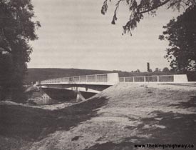
Above - Newly-completed Catfish Creek Bridge on Hwy 73 in Port Bruce (1964) (Photo courtesy of Ontario Ministry of Transportation - © King's Printer for Ontario, 1964) 
Above - Circa 1970 postcard view of Hwy 3 (Talbot Street) in Downtown Aylmer, facing east from the Hwy 73 Junction. See an
Enlarged Photo Here. (Photo courtesy of Eric Green) |
|---|
|
Present Day King's Highway 73 Photographs

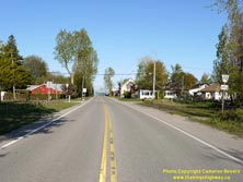
Left - Facing north along Hwy 73 towards Aylmer from the highway's southern terminus in Port Bruce. See an
Enlarged Photo Here. (Photograph taken on May 10, 2012 - © Cameron Bevers) Right - Southern terminus of Hwy 73 in Port Bruce. Since the highway was transferred in the 1990s, the section of Hwy 73 between Port Bruce and Aylmer has been under the jurisdiction of the County of Elgin. The route of Hwy 73 is no longer a King's Highway under the jurisdiction of the province, as the entire highway was transferred to municipalities in 1997-1998. See an Enlarged Photo Here. (Photograph taken on May 10, 2012 - © Cameron Bevers) 
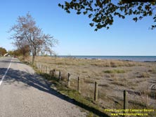
Left - Facing south along Hwy 73 at Port Bruce Provincial Park. Like many of Ontario's Provincial Parks, this roadside park on Hwy 73 was once administered by
the Department of Highways of Ontario for the convenience of motorists. Hundreds of roadside parks such as this one were built along Ontario's Highways between the
1930s and 1960s. See an Enlarged Photo Here. (Photograph taken on May 10, 2012 - © Cameron Bevers) Right - The beach on Hwy 73 in Port Bruce is a popular destination in summertime. See an Enlarged Photo Here. (Photograph taken on May 10, 2012 - © Cameron Bevers) 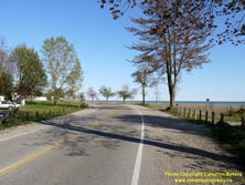

Left - Approaching Port Bruce Beach on Hwy 73, facing south. This highway diversion was constructed across the beach in 1949, in order to provide a more direct
access route to the beach area. Previously, traffic on Hwy 73 had to wind its way through the narrow streets of Port Bruce in order to reach the beach area. See an
Enlarged Photo Here. (Photograph taken on May 10, 2012 - © Cameron Bevers) Right - Western side of the Catfish Creek Bridge on Hwy 73 in Port Bruce. On February 23, 2018, the Catfish Creek Bridge suffered a catastrophic failure and collapsed into the river below. The cause of the failure is not known as this time and is under investigation. Hwy 73 will be closed at this crossing for the foreseeable future. See an Enlarged Photo Here. (Photograph taken on May 10, 2012 - © Cameron Bevers) 

Left - Facing south across the Catfish Creek Bridge on Hwy 73 towards Port Bruce. See an
Enlarged Photo Here. (Photograph taken on May 10, 2012 - © Cameron Bevers) Right - Eastern side of the Hwy 73 Bridge in Port Bruce over Catfish Creek. See an Enlarged Photo Here. (Photograph taken on May 10, 2012 - © Cameron Bevers) 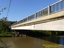

Left - Close-up of the Catfish Creek Bridge on Hwy 73. The structure consisted of two post-tensioned approach spans (each with a length of 37 feet, 3 inches)
along with a 153-foot prestressed concrete girder centre span. As a result of the bridge failure in 2018, Hwy 73 will remain closed at Catfish Creek indefinitely.
Traffic can still access Port Bruce via Dexter Line (Elgin Road 24). See an Enlarged Photo Here. (Photograph taken on May 10, 2012 - © Cameron Bevers) Right - Facing north along Hwy 73 towards Aylmer at the Catfish Creek Bridge. This three-span structure was completed in 1964. It replaced an old narrow through truss bridge located a short distance downstream, which had limited overhead clearance that proved to be very difficult for large trucks to negotiate. See an Enlarged Photo Here. (Photograph taken on May 10, 2012 - © Cameron Bevers) 

Left - Aerial view of the Hwy 73 interchange at Hwy 401 facing north. This former cloverleaf interchange was converted to a diamond interchange
during a Hwy 401 widening project in the early 1990s. Traces of the old cloverleaf loop ramps are still evident when the interchange is viewed from the air. (Photograph taken on April 28, 2006 - © Cameron Bevers) Right - Aerial view of the Hwy 73 and Hwy 401 Interchange, facing northeast. (Photograph taken on April 28, 2006 - © Cameron Bevers)
More King's Highway 73 Photographs Coming Soon!
|
|---|
Links to Adjacent King's Highway Photograph Pages:
Back to King's Highway 72 Photos /
King's Highway 73 History /
On to King's Highway 74 Photos
Ontario Highway History - Main Menu / Back to List of Highways Website contents, photos & text © 2002-2025, Cameron
Bevers (Webmaster) - All Rights Reserved / Contact Me |
|---|