
| 
| |
|
|
This page contains historical and present day photos of Ontario's King's Highway 7A, which ran from Highway 7 &
Highway 12 at Manchester easterly to Peterborough. All photographs displayed on this page were taken by the Webmaster (Cameron Bevers), unless specifically noted
otherwise. Historical photographs are arranged in approximate chronological order, while present day photographs (Year 2000 to date) are arranged by location from
west to east. Click on any thumbnail to see a larger image!
Please note that all photographs displayed on this
website are protected by copyright. These photographs must not be reproduced, published,
electronically stored or copied, distributed, or posted onto other websites without
my written permission. If you want to use photos from this website, please
email me first for permission. Thank-you!
|
|---|
|
Historical King's Highway 7A Photographs

Above - Aerial view of the Hwy 7A Junction on Hwy 115 east of Cavan in 1972. This was one of several at-grade intersections along Hwy 115
that was grade-separated during the twinning of Hwy 115 in the early 1990s. In addition to being widened from two to four lanes, Hwy 115 was also converted into a
fully controlled-access freeway between the Hwy 35 Interchange at Enterprise Hill and the Hwy 28 Interchange southwest of Peterborough. (Photo courtesy of Ontario Ministry of Transportation - © King's Printer for Ontario, 2012) 
Above - Aerial view of the Hwy 28 Interchange on Hwy 115 (historically Hwy 115 & Hwy 7A) southwest of Peterborough in 1972, facing south towards Port Hope. This interesting photo shows the
partially-completed interchange, as it appeared before the extension of Hwy 115 to the Peterborough Bypass in the late 1970s. When Hwy 115 was first opened to
traffic in 1954, the highway terminated at a "T" Junction at Hwy 28. As traffic volumes grew over the years, the number of vehicles turning left onto Hwy 28 at the
end of Hwy 115 started to cause significant congestion at this highway junction. In 1966-1967, a partial interchange was built at Hwy 115 & Hwy 28 as an interim improvement until Hwy 115
was extended easterly from Hwy 28 to the Peterborough Bypass. This interim improvement proved to be very effective, as it successfully accommodated the heavy
left-turn movement from Hwy 115 via a grade separation over Hwy 28. A loop ramp carried Hwy 115 traffic north towards Peterborough uninterrupted. It wasn't until 1978
that Hwy 115 was finally extended easterly from Hwy 28 to the Peterborough Bypass. The Hwy 28 Interchange was reconfigured when this section of Hwy 115 was
twinned in 1985. See an Enlarged Photo Here. (Photo courtesy of Ontario Ministry of Transportation - © King's Printer for Ontario, 2012) |
|---|
|
Present Day King's Highway 7A Photographs


Left - Facing east along Hwy 7A towards Yelverton from Nestleton Station. See an
Enlarged Photo Here. (Photograph taken on September 30, 2007 - © Cameron Bevers) Right - Facing east along Hwy 7A from Yelverton towards the Hwy 35 Junction. See an Enlarged Photo Here. (Photograph taken on September 30, 2007 - © Cameron Bevers) 

Left - Facing east along Hwy 7A at the Pigeon River Bridge near Yelverton. (Photograph taken on September 30, 2007 - © Cameron Bevers) Right - Southern side of the Pigeon River Bridge on Hwy 7A. Structure completed in 1950. (Photograph taken on September 30, 2007 - © Cameron Bevers) 

Left - Facing west along Hwy 7A towards Yelverton at the Pigeon River Bridge. (Photograph taken on September 30, 2007 - © Cameron Bevers) Right - Northern side of the Pigeon River Bridge on Hwy 7A near Yelverton. (Photograph taken on September 30, 2007 - © Cameron Bevers) 

Left - Sign marking the turn-off to Hwy 35 North at the Hwy 7A Junction near Yelverton. (Photograph taken on September 30, 2007 - © Cameron Bevers) Right - Route marker assembly at the Hwy 7A and Hwy 35 Junction near Yelverton. The two highways run concurrently from this point south for 1.5 km, before Hwy 7A turns east again towards Bethany and Peterborough. (Photograph taken on September 30, 2007 - © Cameron Bevers) 

Left - Approaching the Hwy 35 Junction on Hwy 7A near Yelverton. See an
Enlarged Photo Here. (Photograph taken on September 30, 2007 - © Cameron Bevers) Right - Facing north along Hwy 35 towards Lindsay from the Hwy 7A Junction. (Photograph taken on September 30, 2007 - © Cameron Bevers) 
Above - Approaching the Hwy 115 Interchange on Hwy 7A near Cavan, facing east. See an
Enlarged Photo Here. (Photograph taken on August 25, 2012 - © Cameron Bevers) 

Left - Facing west along Hwy 7A towards Cavan from the Hwy 115 Interchange. From Hwy 115,
Hwy 7A continues westerly for almost 50 km to Hwy 7 & Hwy 12 via Cavan, Bethany and Port Perry. The highway was established as an alternate route to Hwy 7 just
prior to World War II. See an Enlarged Photo Here. (Photograph taken on August 25, 2012 - © Cameron Bevers) Right - This square route marker advises eastbound motorists that Hwy 7A ends at the Hwy 115 Interchange. The eastern terminus of Hwy 7A is rather well-signed, as the highway at one time continued easterly towards Peterborough beyond this interchange. Prior to 2003, Hwy 7A continued east from here along a concurrent route with Hwy 115. See an Enlarged Photo Here. (Photograph taken on August 25, 2012 - © Cameron Bevers) 

Left - The southbound Hwy 115 exit ramp to westbound Hwy 7A is almost tangential, due to the skewed crossing of Hwy 7A at Hwy 115. Although Hwy 115 is signed
with north and south cardinal directions, the highway actually trends along a northeast and southwest line between Enterprise Hill and Peterborough. See an
Enlarged Photo Here. (Photograph taken on August 25, 2012 - © Cameron Bevers) Right - Southern side of the Hwy 7A Overpass on Hwy 115 near Cavan. This four-span post-tensioned concrete structure was completed in 1990. Click here to see a Historical 1972 Photo of the Hwy 7A & Hwy 115 Junction, when the intersection was still at-grade. See an Enlarged Photo Here. (Photograph taken on August 25, 2012 - © Cameron Bevers) 

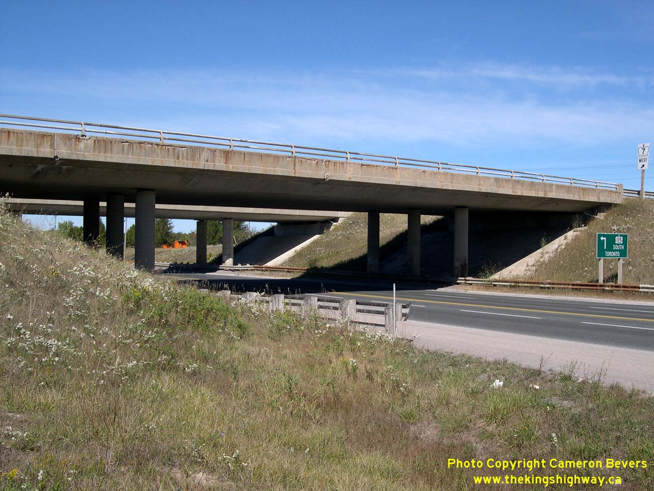
Left - An older green guide sign for Hwy 115 South to Toronto at the Hwy 7A Interchange. See an
Enlarged Photo Here. (Photograph taken on August 25, 2012 - © Cameron Bevers) Right - View of Hwy 115 at the Hwy 7A Interchange, facing north towards Peterborough. Note that both the northbound and southbound lanes of Hwy 115 are surfaced with concrete at this interchange. When this section of Hwy 115 was twinned in 1989-1990, a median crossover existed here. South of the Hwy 7A Interchange, the original two-lane route of Hwy 115 followed the present southbound lanes of the freeway. From this point northerly to the Hwy 28 Interchange, the original highway forms the northbound lanes of the freeway. See an Enlarged Photo Here. (Photograph taken on August 25, 2012 - © Cameron Bevers) 

Left - Date stamp (1990) and structure identification number (Site #21-446) on the Hwy 7A Overpass on Hwy 115 near Cavan. See an
Enlarged Photo Here. (Photograph taken on August 25, 2012 - © Cameron Bevers) Right - Facing east across the Hwy 7A Overpass on Hwy 115 near Cavan. See an Enlarged Photo Here. (Photograph taken on August 25, 2012 - © Cameron Bevers) 

Left - Facing south along Hwy 115 towards Newcastle from the Hwy 7A Overpass near Cavan. See an
Enlarged Photo Here. (Photograph taken on August 25, 2012 - © Cameron Bevers) Right - Hwy 7A Overpass on Hwy 115, facing west towards Cavan. See an Enlarged Photo Here. (Photograph taken on August 25, 2012 - © Cameron Bevers) 

Left - Green guide sign marking the entrance ramp to northbound Hwy 115. A second sign below acts as a trailblazer to Hwy 7, since Hwy 7A no longer connects
directly to Hwy 7 at its eastern end. The overlapped route of Hwy 7A & Hwy 115 east of this interchange was discontinued in 2003, in an effort to simplify route
numbering in the Peterborough area. However, any motorist who enters the freeway at this point will automatically end up on Hwy 7 at the next interchange. See an
Enlarged Photo Here. (Photograph taken on August 25, 2012 - © Cameron Bevers) Right - The entrance ramp from Hwy 7A joins into the northbound lanes of Hwy 115 at left. At one time, the overlapped route of Hwy 7A & Hwy 115 extended easterly for one interchange where Hwy 7A exited the freeway and turned north to Springville. This former overlapped route made the highway signing in this area unnecessarily complicated and is far better in its current configuration, in my personal opinion. See an Enlarged Photo Here. (Photograph taken on August 25, 2012 - © Cameron Bevers) 

Left - Fingerboard guide signs and route marker at the northbound Hwy 115 exit ramp terminal at Hwy 7A. It is unusual to see a King's Highway marked with a
fingerboard guide sign like this. At one time, Moore Drive lying to the east of the Hwy 115 Interchange was also part of Hwy 7A. This eastern section of Hwy 7A via
Moore Drive was bypassed when Hwy 115 first opened to traffic in 1954. See an
Enlarged Photo Here. (Photograph taken on August 25, 2012 - © Cameron Bevers) Right - A second sign advises eastbound motorists that Hwy 7A ends. Between 1938 and 1954, Hwy 7A continued straight ahead towards Hwy 28 via today's Moore Drive. Jurisdiction over this bypassed section of Hwy 7A was transferred from the DHO to the Township of Cavan in November 1954. See an Enlarged Photo Here. (Photograph taken on August 25, 2012 - © Cameron Bevers) 
Left - Facing north towards Fowlers Corners at the Hwy 28 Interchange on Hwy 7 & Hwy 115 at Springville, southwest of Peterborough. Prior to the extension
of Hwy 115 from Springville to Peterborough in 1978, Hwy 115 used to end at this interchange. Until 1984, Hwy 28 used to continue straight through (north) towards
Five Mile Corners, located south of Fowlers Corners. Hwy 28 was rerouted southwest of Peterborough in the 1980s and was signed concurrently with Hwy 115 between 1984
and 2003. Originally, Hwy 7 did not pass through this interchange at all. However, the Hwy 7 designation was applied to the highway through Springville in 2003, in order
to close a gap left over when a section of Hwy 7 (North Monaghan Parkway and Sir Sandford Fleming Drive) was downloaded to the County of Peterborough in 1997. See an
Enlarged Photo Here. (Photograph taken on September 23, 2007 - © Cameron Bevers) Right - Dual underpass structures carry the freeway over Hwy 28. The northbound Hwy 115 structure is much older than the southbound Hwy 115 structure, due to the fact that Hwy 115 was constructed as a staged freeway through this interchange. Hwy 115 was initially built as an undivided two-lane highway, but was later expanded to a four-lane freeway in the mid-1980s. Click here to see a Historical 1972 Photo of the partially-completed Hwy 28 Interchange on Hwy 115, showing the former northern terminus of Hwy 115. See an Enlarged Photo Here. (Photograph taken on September 23, 2007 - © Cameron Bevers) 

Left - Northbound Hwy 115 underpass at the Hwy 28 Interchange near Peterborough. This three-span post-tensioned concrete structure was completed in 1966. See
an Enlarged Photo Here. (Photograph taken on September 23, 2007 - © Cameron Bevers) Right - Structure identification number and date stamp (1966) on the northbound Hwy 115 structure at the Hwy 28 Interchange. See an Enlarged Photo Here. (Photograph taken on September 23, 2007 - © Cameron Bevers) 

Left - Western side of the northbound Hwy 115 structure at the Hwy 28 Interchange at Springville. See an
Enlarged Photo Here. (Photograph taken on September 23, 2007 - © Cameron Bevers) Right - Southbound Hwy 115 structure at the Hwy 28 Interchange. This three-span post-tensioned concrete structure was completed in 1985. See an Enlarged Photo Here. (Photograph taken on September 23, 2007 - © Cameron Bevers) 

Left - Date stamp (1985) on the southbound Hwy 115 structure at the Hwy 28 Interchange. See an
Enlarged Photo Here. (Photograph taken on September 23, 2007 - © Cameron Bevers) Right - Facing north along Hwy 7 & Hwy 115 (Formerly Hwy 28 & Hwy 115) towards Peterborough from the Hwy 28 Interchange near Springville. See an Enlarged Photo Here. (Photograph taken on September 23, 2007 - © Cameron Bevers) 
Above - Hwy 7 & Formerly Hwy 7A route markers near Springville. These route markers have remained on the road ever since the recent renumbering of a
section of Hwy 7A as Hwy 7 through Springville in 2003. This section of highway west of Peterborough has been renumbered more times than any other route in Ontario's
provincial highway history. The highway route number(s) through Springville has changed no fewer than seven times since highway numbering was first introduced in Ontario
in 1925. Initially the highway was known as Hwy 12A (1925-1928), which later changed to Hwy 28 (1928-1938), which then became Hwy 28 & Hwy 7A (1938-1960), then
Hwy 28 (1960-1964), then Hwy 28 & Hwy 115 (1964-1970), then Hwy 28 (1970-1984), then Hwy 7A (1984-2003), and then finally Hwy 7 (2003-Present). Anyone lost yet? (Photograph taken on July 9, 2006 - © Cameron Bevers) 
Above - Hwy 7 (Former Hwy 7A) descends this steep grade at Springville, just west of Peterborough. The Hwy 115 Interchange lies about 3 km ahead. See an
Enlarged Photo Here. (Photograph taken on July 9, 2006 - © Cameron Bevers)
More King's Highway 7A Photographs Coming Soon!
|
|---|
Links to Adjacent King's Highway Photograph Pages:
Back to King's Highway 7 Photos /
King's Highway 7A History /
On to King's Highway 8 Photos
Ontario Highway History - Main Menu / Back to List of Highways Website contents, photos & text © 2002-2026, Cameron
Bevers (Webmaster) - All Rights Reserved / Contact Me
|
|---|