| 
|  |
|
|
This page contains historical and present day photos of Ontario's King's Highway 7B (Madoc Business Route). All photographs
displayed on this page were taken by the Webmaster (Cameron Bevers), unless specifically noted otherwise. Historical photographs are arranged in approximate
chronological order, while present day photographs (Year 2000 to date) are arranged by location from west to east. Click on any thumbnail to see a larger image!
Please note that all photographs displayed on this
website are protected by copyright. These photographs must not be reproduced, published,
electronically stored or copied, distributed, or posted onto other websites without
my written permission. If you want to use photos from this website, please
email me first for permission. Thank-you!
|
|---|
|
Present Day King's Highway 7B (Madoc) Photographs


Left - Junction sign assembly at the western end of St. Lawrence Street (Former Hwy 7B) at the Madoc Bypass (Hwy 7). The nearby route of Hwy 62 is signed using
a green-and-white trailblazer route marker from this intersection via Hwy 7 East. The Madoc Bypass was constructed in the 1960s in order to carry through traffic on
Hwy 7 around the village centre. An improved junction between Hwy 7 and Hwy 62 was also constructed as part of the Madoc Bypass. See an
Enlarged Photo Here. (Photograph taken on August 26, 2012 - © Cameron Bevers) Right - Facing west along Hwy 7 towards Marmora from the Former Hwy 7B Junction (St. Lawrence Street) west of Madoc. See an Enlarged Photo Here. (Photograph taken on August 26, 2012 - © Cameron Bevers) 

Left - Facing east along Hwy 7 at the start of the Madoc Bypass approaching the Former Hwy 7B Junction. Prior to the completion of the Madoc Bypass in the
1960s, Hwy 7 traffic entered into Madoc via St. Lawrence Street. To the right of the green guide sign, a rock cut marks the old location of Hwy 7 approaching Madoc.
As part of the construction of the Madoc Bypass, this short section of Hwy 7 west of Madoc was abandoned entirely. St. Lawrence Street (Former Hwy 7B) was realigned
so that it intersected with the Madoc Bypass closer to a right angle. See an Enlarged Photo Here. (Photograph taken on August 26, 2012 - © Cameron Bevers) Right - Old rock cut on a former alignment of Hwy 7 approaching Madoc. This section of Hwy 7 was abandoned as a result of the construction of the Madoc Bypass. See an Enlarged Photo Here. (Photograph taken on August 26, 2012 - © Cameron Bevers) 

Left - Abandoned section of Hwy 7 at the western end of the Madoc Bypass. This old highway pavement last carried through traffic back in 1967. See an
Enlarged Photo Here. (Photograph taken on August 26, 2012 - © Cameron Bevers) Right - Junction of Hwy 7 and Former Hwy 7B (St. Lawrence Street) at the western entrance to Madoc. As was typical for bypassed sections of highway during that era, the old route of Hwy 7 via St. Lawrence Street was signed as Hwy 7B for a short period after the Madoc Bypass opened to traffic. See an Enlarged Photo Here. (Photograph taken on August 26, 2012 - © Cameron Bevers) 

Left - Facing east along St. Lawrence Street (Former Hwy 7B) from the Madoc Bypass. St. Lawrence Street served as the route of Hwy 7 from the mid-1930s up
until the late 1960s, when it was replaced by the new Madoc Bypass. The former route of Hwy 7 through Madoc was briefly signed as Hwy 7B during the late 1960s.
Jurisdiction over Hwy 7B was transferred from the province to the County of Hastings in July 1969. For many years, Old Hwy 7B was part of Hastings County Road 23. See
an Enlarged Photo Here. (Photograph taken on August 26, 2012 - © Cameron Bevers) Right - View of Hwy 7 at the Former Hwy 7B Junction (St. Lawrence Street) west of Madoc, facing west towards Marmora. See an Enlarged Photo Here. (Photograph taken on August 26, 2012 - © Cameron Bevers) 
Above - Facing east along the Madoc Bypass (Hwy 7) from the Former Hwy 7B Junction (St. Lawrence Street). Construction of the 4.5 km Madoc Bypass commenced in
1965, with final paving and tie-ins with Old Hwy 7 constructed under Contract #1966-167. The Madoc Bypass was opened to traffic on September 18, 1967. See an
Enlarged Photo Here. (Photograph taken on August 26, 2012 - © Cameron Bevers) 

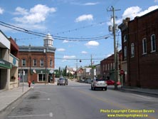
Left - Deer Creek Bridge on Old Hwy 7 (now Hwy 62) in Madoc. Structure completed in 1949. (Photograph taken on July 24, 2005 - © Cameron Bevers) Right - Junction of Old Hwy 7 and Hwy 62 at St. Lawrence Street and Durham Street in Downtown Madoc, facing east. Originally, Hwy 7 continued straight through at this intersection on its route towards Ottawa. After the Madoc Bypass was completed in 1967, the old route of Hwy 7 became Hwy 7B. Although Hwy 7B was decommissioned many years ago, this intersection still serves a King's Highway. At this intersection, Hwy 62 turns right and proceeds south towards Belleville. See an Enlarged Photo Here. (Photograph taken on July 24, 2005 - © Cameron Bevers) 

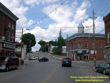
Left - Facing north along Hwy 62 (Durham Street) towards the Old Hwy 7 Junction (St. Lawrence Street) in Downtown Madoc. To continue north on Hwy 62,
northbound traffic must turn left at this intersection. For a brief period during the 1960s, Hwy 7 and Hwy 62 shared a short concurrent route through Madoc,
but it was discontinued after the Madoc Bypass was completed and opened to traffic in 1967. St. Lawrence Street was briefly signed as Hwy 7B, until the
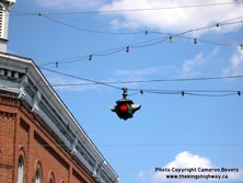
business route was decommissioned in 1970. (Photograph taken on July 24, 2005 - © Cameron Bevers) Right - This overhead flashing beacon at Old Hwy 7 and Hwy 62 in Downtown Madoc likely dates from the 1950s. (Photograph taken on July 24, 2005 - © Cameron Bevers) 
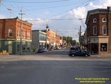
Above - Facing south along Hwy 62 from St. Lawrence Street (Old Hwy 7) in Downtown Madoc. See an
Enlarged Photo Here. (Photograph taken on August 17, 2008 - © Cameron Bevers)
More King's Highway 7B Photographs Coming Soon!
|
|---|
Links to Adjacent King's Highway Photograph Pages:
Back to King's Highway 7 Photos /
King's Highway 7B (Madoc) History /
On to King's Highway 8 Photos
Ontario Highway History - Main Menu / Back to List of Highways Website contents, photos & text © 2002-2025, Cameron
Bevers (Webmaster) - All Rights Reserved / Contact Me |
|---|