
| 
| |
|
|
This page contains historical and present day photos of Ontario's King's Highway 7B (Peterborough Business Route). All
photographs displayed on this page were taken by the Webmaster (Cameron Bevers), unless specifically noted otherwise. Historical photographs are arranged in
approximate chronological order, while present day photographs (Year 2000 to date) are arranged by location from west to east. Click on any thumbnail to see a larger
image!
Please note that all photographs displayed on this
website are protected by copyright. These photographs must not be reproduced, published,
electronically stored or copied, distributed, or posted onto other websites without
my written permission. If you want to use photos from this website, please
email me first for permission. Thank-you!
|
|---|
|
Historical King's Highway 7B (Peterborough) Photographs
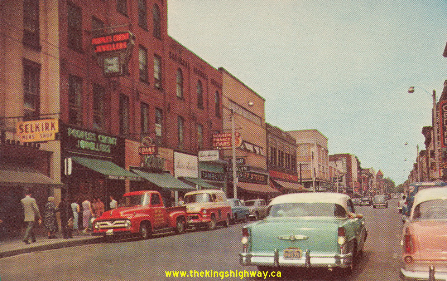
Above - Postcard view of Hwy 7 (George Street) in Downtown Peterborough in 1956, facing north from the Hwy 28 Junction at Charlotte Street. This interesting
photo shows George Street just before the one-way street system was introduced through Downtown Peterborough in the late 1950s. Today, George Street carries
southbound traffic only, while northbound traffic follows adjacent Water Street through the city centre. See an
Enlarged Photo Here. Photo taken in 1956. (Photo courtesy of Royal Specialty Sales, Toronto) |
|---|
|
Present Day King's Highway 7B (Peterborough) Photographs


Left - Facing west along Peterborough Road 1 (Former Hwy 7B) about 6 km east of Fowlers Corners. Up until 1960, this route was part of Hwy 7. At a result of
the completion of the West Peterborough Bypass, the old route of Hwy 7 leading into Downtown Peterborough from Fowlers Corners was renumbered as Hwy 7B. Unlike most
of Ontario's "B" Business Routes, Peterborough's Hwy 7B had an unusually long rural section north of the city, in addition to the more typical urbanized portions of
the business route through Downtown. Peterborough's Hwy 7B was nearly 20 km in length. See an
Enlarged Photo Here. (Photograph taken on July 9, 2006 - © Cameron Bevers) Right - Green guide sign approaching the Peterborough Road 1 (Former Hwy 7B) Junction at Chemong Corners. Up until 1997, Hwy 7B turned left at Chemong Corners on its route west between Peterborough and Fowlers Corners. Note that the old Hwy 7B provincial highway crown on the sign has been covered over by a county road "flowerpot" marker. See an Enlarged Photo Here. (Photograph taken on July 9, 2006 - © Cameron Bevers) 

Left - Facing north along Peterborough Road 18 (Former Hwy 7B) about 4 km north of Peterborough. Prior to 1997, Hwy 7B turned left towards Fowlers Corners at
the traffic signals at Chemong Corners in the background. See an Enlarged Photo Here. (Photograph taken on July 9, 2006 - © Cameron Bevers) Right - Peterborough Road 18 (Former Hwy 7B) about 2 km north of Peterborough, facing north towards Chemong Corners. See an Enlarged Photo Here. (Photograph taken on July 9, 2006 - © Cameron Bevers) 

Left - Facing east along Charlotte Street (Former Hwy 28 & Hwy 115) at Monaghan Road (Former Hwy 7B). Prior to 1997, Hwy 28 turned left at this
intersection and headed north along Monaghan Road concurrently with Hwy 7B. The route of Hwy 115 reached its pre-1997 northern terminus at this junction. The route of
Hwy 7B also continued south from here along Monaghan Road to Lansdowne Street, where the route of Hwy 7B turned easterly towards the Peterborough Bypass and Ottawa.
As a result of the downloading of various highways and revocation of municipal connecting links in the Peterborough area in 1997-1998, there are no longer any
provincial highways which pass through the urbanized sections of Peterborough. See an
Enlarged Photo Here. (Photograph taken on July 9, 2006 - © Cameron Bevers) Right - Ground-mounted freeway guide sign for Hwy 7 East at the end of the Peterborough Bypass. Although Hwy 7 continues east from Peterborough towards Norwood, Madoc and eventually Ottawa, Hwy 115 reaches its northern terminus at the traffic signals just ahead. See an Enlarged Photo Here. (Photograph taken on September 23, 2007 - © Cameron Bevers) 

Left - Eastern end of the Peterborough Bypass (Hwy 7 & Hwy 115) approaching Lansdowne Street. At one time, Lansdowne Street west of this intersection was a
signed business route (Hwy 7B) which passed through Peterborough. After a rather circuitous loop, Peterborough's Hwy 7B connected back to Hwy 7 west of the city at
Fowlers Corners. See an Enlarged Photo Here. (Photograph taken on September 23, 2007 - © Cameron Bevers) Right - Green guide signs on westbound Hwy 7 approaching the Peterborough Bypass and Lansdowne Street (Former Hwy 7B). See an Enlarged Photo Here. (Photograph taken on September 23, 2007 - © Cameron Bevers) 

Left - Ground-mounted guide sign marking the former route of Hwy 7B into Peterborough via Lansdowne Street. The route of Hwy 7B was decommissioned as a King's
Highway in 1997, although the green patch placed over the old Hwy 7B crown is still quite obvious. This sign was replaced shortly after this photo was taken in 2007.
See an Enlarged Photo Here. (Photograph taken on September 23, 2007 - © Cameron Bevers) Right - Facing west along Hwy 7 approaching the Peterborough Bypass Junction. At the traffic signals, Hwy 7 turns left and begins a concurrent overlapped route with Hwy 115. Up until 1997, motorists could also follow the Hwy 7B Business Route through Peterborough. Although much longer that the route offered by Hwy 7, Peterborough's Hwy 7B did form a complete loop. It eventually reconnected back to Hwy 7 at Fowlers Corners. The ramp seen joining in at left carries traffic from the Peterborough Bypass to eastbound Hwy 7. See an Enlarged Photo Here. (Photograph taken on September 23, 2007 - © Cameron Bevers) 

Left - View of the eastern terminus of the Peterborough Bypass (Hwy 7 & Hwy 115), facing west from Lansdowne Street. See an
Enlarged Photo Here. (Photograph taken on September 23, 2007 - © Cameron Bevers) Right - Green guide signs on eastbound Lansdowne Street (Formerly Hwy 7B) approaching the Peterborough Bypass. Although it isn't indicated on these signs, traffic heading straight through at this intersection will join Hwy 7 East to Ottawa. See an Enlarged Photo Here. (Photograph taken on September 23, 2007 - © Cameron Bevers) 
Above - Facing east along Hwy 7 towards Norwood from the Hwy 115 and Former Hwy 7B Junction in Peterborough. See an
Enlarged Photo Here. (Photograph taken on September 23, 2007 - © Cameron Bevers)
More King's Highway 7B Photographs Coming Soon!
|
|---|
Links to Adjacent King's Highway Photograph Pages:
Back to King's Highway 7 Photos /
King's Highway 7B (Peterborough) History /
On to King's Highway 8 Photos
Ontario Highway History - Main Menu / Back to List of Highways Website contents, photos & text © 2002-2026, Cameron
Bevers (Webmaster) - All Rights Reserved / Contact Me
|
|---|