| 
| |
|
|
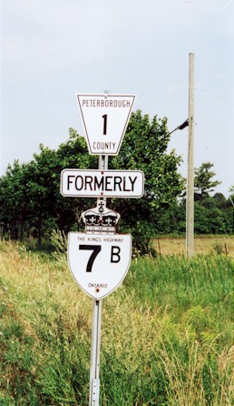
History of King's Highway 7B (Peterborough):
Peterborough's Highway 7B was the second-longest business route to ever exist in Ontario. It was also the longest of the numerous Highway 7B routes which were
established throughout the province during the 1950s, 1960s and 1970s. The route of Highway 7B through Peterborough was first established in 1960, when Highway 7 was
relocated onto a new route between Peterborough and Fowlers Corners. The old route of Highway 133 from
Fowlers Corners to Five Mile Corners west of Peterborough was re-designated as Highway 7. Highway 7 was then routed along Lansdowne Street from Five Mile Corners
easterly into Peterborough. The original route of Highway 7 via Lindsay Highway, Chemong Road, Reid Street, McDonnel Street, Sherbrooke Street, George Street and
Water Street was re-designated as Highway 7B (See Map). Parts of
Highway 7B ran concurrently with Peterborough's other Business Route, Highway 28B. The route of Highway 7B began at Fowlers Corners located northwest of Peterborough
and ended initially at the intersection of George Street and Lansdowne Street in Peterborough. Numerous routes of Highway 7B were utilized over the years. When the Peterborough Bypass was completed and opened to traffic in October, 1961, Highway 7 was relocated onto the new bypass. As a result, Highway 7B assumed the balance of the old route of Highway 7 via Lansdowne Street, Otonabee Street and Downer Street between the intersection of George Street and the eastern end of the Peterborough Bypass (See Map). The route of Highway 28B was decommissioned in 1964, triggering a relocation of Highway 7B onto a new route through Peterborough. The new route of Highway 7B was routed concurrently with Highway 28. The two highways ran along Park Hill Road from Chemong Road to Monaghan Road. At Monaghan Road, Highway 7B turned south, and ran southerly to Lansdowne Street. At Lansdowne Street, Highway 7B turned east and ended at its previous terminus at the eastern end of the Peterborough Bypass (See Map). In 1970, Highway 7B was apparently restored to its original 1960-1964 route through Downtown Peterborough, via Reid Street, McDonnel Street, Sherbrooke Street, George Street and Water Street (See Map). In 1974, the route of Highway 7B was restored to its 1964-1970 route, via Park Hill Road and Monaghan Road. The route via Park Hill Road and Monaghan Road remained in place right up until the 1990s (See Map). In the late 1990s, the entire route of Highway 7B was decommissioned. The rural section of Highway 7B from the Highway 7 Junction at Fowlers Corners to the City of Peterborough Limits on Chemong Road near Milroy Drive was transferred to the County of Peterborough, effective March 31, 1997. The remainder of the route of Highway 7B through the City of Peterborough was not assumed by the province, and thus those portions of the highway were already under the jurisdiction of the City of Peterborough. Route markers for Highway 7B within the City of Peterborough were removed in the late 1990s, erasing any evidence that this business route ever existed. The route of Highway 7B from Fowlers Corners to Chemong Road via Lindsay Highway is now known as Peterborough County Road 1. The route of Highway 7B via Chemong Road is now known as Peterborough County Road 18. Within Peterborough, the former route of Highway 7B is known as Chemong Road, Park Hill Road, Monaghan Road and Lansdowne Street. 
 |
|---|
Links to Adjacent King's Highway Pages: 


Website contents, photos & text © 2002-2025, Cameron
Bevers (Webmaster) - All Rights Reserved / Contact Me |
|---|