
| 
| |
|
|
This page contains historical photos of Ontario's King's Highway 89 dating from 1937 to 1999. All photographs displayed on
this page were taken by the Ontario Ministry of Transportation, unless specifically noted otherwise. Historical photographs are arranged in approximate chronological
order. Click on any thumbnail to see a larger image!
Please note that all photographs displayed on this
website are protected by copyright. These photographs must not be reproduced, published,
electronically stored or copied, distributed, or posted onto other websites without
my written permission. If you want to use photos from this website, please
email me first for permission. Thank-you!
|
|---|
|
Page 1: Historical King's Highway 89 Photographs

Above - Circa 1938 postcard view of Victoria Street (Hwy 89) in Downtown Alliston. See an
Enlarged Photo Here. (Photo courtesy of the Photogelatine Engraving Company Ltd, Ottawa) 
Above - Facing east along Hwy 89 at Violet Hill in 1957, about 3 miles east of the Hwy 10 & Hwy 24 Junction at Primrose. Under Contract #1956-14, Hwy 89
was reconstructed on an improved alignment from 1 mile east of Rosemount to the Hwy 10 & Hwy 24 Junction at Primrose. In the background, a new highway diversion
carries Hwy 89 traffic around the small community of Violet Hill. See an Enlarged Photo Here.
Photo taken on July 18, 1957. (Photo courtesy of Ontario Ministry of Transportation - © King's Printer for Ontario, 1957) 

Left - Grading on Development Road 384 (now Hwy 89) west of Shelburne in 1958. This road was designated as an extension of Hwy 89 in 1963. See an
Enlarged Photo Here. Photo taken in 1958. (Photo courtesy of Ontario Ministry of Transportation - © King's Printer for Ontario, 1958) Right - Facing east along Hwy 89 between Violet Hill and Airport Road, 4 miles east of Primrose. See an Enlarged Photo Here. Photo taken in 1958. (Photo courtesy of Ontario Ministry of Transportation - © King's Printer for Ontario, 1958) 

Left - Swamp excavation on Development Road 384 (now Hwy 89) west of Shelburne. See an
Enlarged Photo Here. Photo taken in 1959. (Photo courtesy of Ontario Ministry of Transportation - © King's Printer for Ontario, 1959) Right - Grading on Development Road 384 (now Hwy 89) on the Dufferin-Grey County Boundary west of Shelburne. See an Enlarged Photo Here. Photo taken in 1959. (Photo courtesy of Ontario Ministry of Transportation - © King's Printer for Ontario, 1959) 

Left - Facing west across the Cookstown Road (today's Hwy 89) Overpass in Innisfil Township. Photo taken in May 1962. (Photo courtesy of Ontario Ministry of Transportation - © King's Printer for Ontario, 2010) Right - Cookstown Road (today's Hwy 89) Overpass on Hwy 400 in Innisfil Township in 1962, facing northwest. The Cookstown Service Centre, with its original British-American (B-A) Station sign, is visible on the far side of the interchange. The Cookstown Service Centre sold B-A gasoline products from its opening in 1954 until 1968, when the station was taken over by Gulf Canada. The station was acquired by Petro-Canada in 1985 and has operated under that company's name ever since. As part of Ontario's recent Service Centre modernization program, the Cookstown Service Centre was closed permanently in February 2013. The historic Hwy 89 Overpass was demolished on October 1, 2022, as part of a multi-year interchange reconstruction project. Photo taken in May 1962. (Photo courtesy of Ontario Ministry of Transportation - © King's Printer for Ontario, 2010) 

Left - Hwy 89 at the Nottawasaga River Bridge at Nicolston in 1963, facing west towards Alliston. See an
Enlarged Photo Here. Photo taken in September 1963. (Photo courtesy of Ontario Ministry of Transportation - © King's Printer for Ontario, 2013) Right - New Nottawasaga River Bridge on Hwy 89 at Nicolston. This three-span steel girder structure was completed and officially opened to traffic in October 1961. See an Enlarged Photo Here. Photo taken in September 1963. (Photo courtesy of Ontario Ministry of Transportation - © King's Printer for Ontario, 2013) 

Left - Hwy 89 at Innisfil Creek (Glass' Bridge) in 1963, facing west towards Cookstown. This interesting photo shows what Hwy 89 looked like mere months after
the Cookstown Road was designated as a provincial highway. From 1937 until 1963, Hwy 89 ended at the Hwy 27 Junction in Cookstown. The completion of Hwy 400 in 1952
changed traffic patterns in the area, resulting in more through traffic using the Cookstown Road to access Hwy 400. In fact, the Cookstown Road became such as
strategic link to Hwy 400 that the provincial government eventually assumed the Cookstown Road as a provincial highway. The Cookstown Road from the Hwy 27 Junction
to the Hwy 400 Interchange was designated as a King's Highway, effective April 25, 1963. See an
Enlarged Photo Here. Photo taken in September 1963. (Photo courtesy of Ontario Ministry of Transportation - © King's Printer for Ontario, 2013) Right - Glass' Bridge on Hwy 89 at Innisfil Creek, between Cookstown and the Hwy 400 Interchange. Photo taken in September 1963. (Photo courtesy of Ontario Ministry of Transportation - © King's Printer for Ontario, 2013) 

Left - Hwy 89 at Innisfil Creek (Glass' Bridge) in 1967, facing east towards the Hwy 400 Interchange. Note how close the roadside trees come to the edge of
the highway - the highway is partially enveloped by the trees. Modern roadside safety standards have resulted in trees being cut far back from the shoulders of
Ontario's Highways, in an effort to reduce the risk of vehicle collisions. See an
Enlarged Photo Here. Photo taken in August 1967. (Photo courtesy of Ontario Ministry of Transportation - © King's Printer for Ontario, 2013) Right - Innisfil Creek Bridge on Hwy 89 (Glass' Bridge) near Cookstown. Photo taken in August 1967. (Photo courtesy of Ontario Ministry of Transportation - © King's Printer for Ontario, 2013) 
Above - Reconstruction of Hwy 89 (known today as Hwy 23) between Palmerston and Harriston, Contract #1968-126. See an
Enlarged Photo Here. Photo taken in 1969. (Photo courtesy of Ontario Ministry of Transportation - © King's Printer for Ontario, 1969) 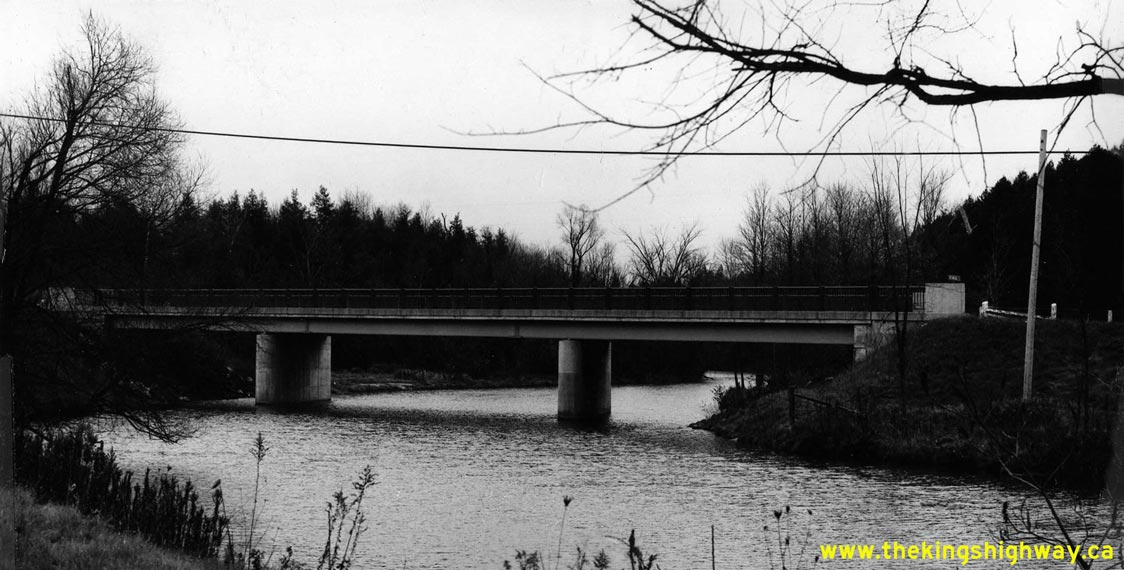
Above - Nottawasaga River Bridge on Hwy 89 at Nicolston, between Cookstown and Alliston. Photo taken in November 1970. (Photo courtesy of Ontario Ministry of Transportation - © King's Printer for Ontario, 2013) 
Above - Glass' Bridge over Innisfil Creek on Hwy 89 east of Cookstown. Photo taken in November 1970. (Photo courtesy of Ontario Ministry of Transportation - © King's Printer for Ontario, 2013) 

Left - Facing east along Hwy 89 towards the Hwy 400 Interchange at Glass' Bridge over Innisfil Creek in 1978. See an
Enlarged Photo Here. Photo taken on July 24, 1978. (Photo courtesy of Ontario Ministry of Transportation - © King's Printer for Ontario, 2013) Right - View of the reconstructed Hwy 89 and County Road 14 Junction at Conn, located between Mount Forest and Shelburne, Contract #1978-75. See an Enlarged Photo Here. Photo taken in 1979. (Photo courtesy of Ontario Ministry of Transportation - © King's Printer for Ontario, 1979) 
Above - Circa 1980 postcard view of the Hwy 87 & Hwy 89 Junction on Elora Street (Hwy 9) in Harriston. See an
Enlarged Photo Here. (Photograph courtesy of Barry Schneider) 

Left - Facing west along Hwy 89 at the Nottawasaga River Bridge at Nicolston in 1983. See an
Enlarged Photo Here. Photo taken on October 13, 1983. (Photo courtesy of Ontario Ministry of Transportation - © King's Printer for Ontario, 2013) Right - Embossed plaque in the northeast concrete barrier wall, commemorating the 1961 opening of the Nottawasaga River Bridge on Hwy 89 at Nicolston. See an Enlarged Photo Here. Photo taken on October 13, 1983. (Photo courtesy of Ontario Ministry of Transportation - © King's Printer for Ontario, 2013) 

Left - Southern side of the Nottawasaga River Bridge on Hwy 89 at Nicolston. Photo taken on October 13, 1983. (Photo courtesy of Ontario Ministry of Transportation - © King's Printer for Ontario, 2013) Right - Northern side of the Nottawasaga River Bridge on Hwy 89 at Nicolston. Photo taken on October 13, 1983. (Photo courtesy of Ontario Ministry of Transportation - © King's Printer for Ontario, 2013) 
Above - Cookstown Ministry of Transportation & Communications Patrol Yard on Hwy 89 west of the Hwy 400 Interchange at Glass' Bridge in 1986. See an
Enlarged Photo Here. Photo taken on July 21, 1986. (Photo courtesy of Ontario Ministry of Transportation - © King's Printer for Ontario, 2013) 

Left - Rehabilitation of the Hwy 89 Overpass on Hwy 400 east of Cookstown, Contract #1988-78. During the rehabilitation, the original steel handrail panels
were removed and replaced with galvanized steel panels which did not require painting. See an
Enlarged Photo Here. Photo taken in April 1989. (Photo courtesy of Ontario Ministry of Transportation - © King's Printer for Ontario, 2010) Right - During the rehabilitation of the Hwy 89 Overpass, the decorative Ontario coat-of-arms were removed from the bridge. See an Enlarged Photo Here. Photo taken in April 1989. (Photo courtesy of Ontario Ministry of Transportation - © King's Printer for Ontario, 2010) 

Left - Construction workers doing concrete removals during the rehabilitation of the Hwy 89 Overpass on Hwy 400 east of Cookstown. See an
Enlarged Photo Here. Photo taken in April 1989. (Photo courtesy of Ontario Ministry of Transportation - © King's Printer for Ontario, 2010) Right - The rehabilitation of the Hwy 89 Overpass under Contract #1988-78 was one of several bridge rehabilitation projects carried out on Hwy 400 in the 1980s and early 1990s. See an Enlarged Photo Here. Photo taken in April 1989. (Photo courtesy of Ontario Ministry of Transportation - © King's Printer for Ontario, 2010)
Continue on to King's Highway 89 Present Day Photos: Palmerston to Mount Forest
|
|---|
Links to Adjacent King's Highway Photograph Pages:
Back to King's Highway 88 Photos /
King's Highway 89 History /
On to King's Highway 90 Photos
Ontario Highway History - Main Menu / Back to List of Highways Website contents, photos & text © 2002-2026, Cameron
Bevers (Webmaster) - All Rights Reserved / Contact Me
|
|---|