
| 
| |
|
|
This page contains present day photos (Year 2000 to date) of Ontario's King's Highway 9, arranged by location from Walkerton
westerly to Kincardine. All photographs displayed on this page were taken by the Webmaster (Cameron Bevers), unless specifically noted otherwise. Click on any
thumbnail to see a larger image!
Please note that all photographs displayed on this
website are protected by copyright. These photographs must not be reproduced, published,
electronically stored or copied, distributed, or posted onto other websites without
my written permission. If you want to use photos from this website, please
email me first for permission. Thank-you!
|
|---|
|
Page 6: Present Day King's Highway 9 Photographs (Walkerton to Kincardine)


Left - Approaching the Yonge Street Junction on Hwy 9 (Formerly Hwy 4 & Hwy 9) in Walkerton, facing east. Until the late 1990s, Hwy 4 & Hwy 9 shared a
brief concurrent route west of Walkerton. All provincially-owned sections of Hwy 4 lying north of Clinton were downloaded to various municipal governments in 1998.
The concurrent route of Hwy 4 & Hwy 9 was discontinued at that time, when the highway leading west from Walkerton was simply renumbered as
Hwy 9. The overlapped route of Hwy 4 & Hwy 9 west of Walkerton had existed since 1930, when Hwy 4 was initially extended north to Walkerton as part of an
ambitious highway construction campaign in Southern Ontario. Prior to its removal, this was one of the longest-standing overlapped highway routes in the province,
lasting just under 68 years. Bruce County now maintains the rural sections of Hwy 4 in the Walkerton area, while the Ministry of Transportation continues to retain
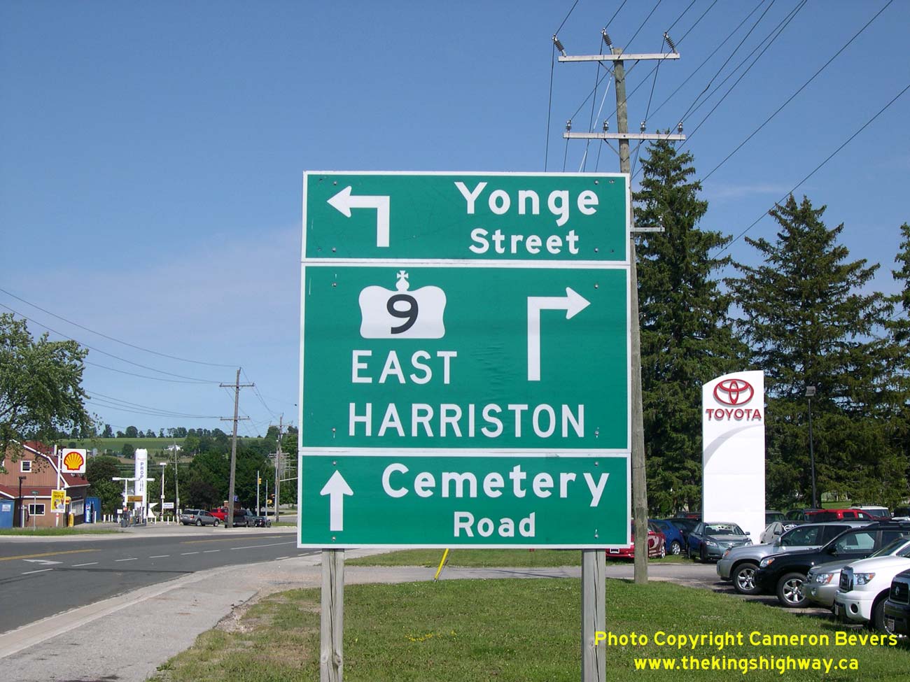
provincial jurisdiction over Hwy 9 through Bruce County. See an Enlarged Photo Here. (Photograph taken on July 1, 2008 - © Cameron Bevers) Right - Guide signs marking the upcoming junction of Hwy 9 and Yonge Street in Walkerton. From this junction, Hwy 9 turns right and continues east towards Harriston. See an Enlarged Photo Here. (Photograph taken on July 1, 2008 - © Cameron Bevers) 

Left - Facing east along Hwy 9 (Formerly Hwy 4 & Hwy 9) at the Yonge Street Junction in Walkerton. At this intersection, Hwy 9 turns right and continues
east towards Harriston, as it has since the route was first established as a provincial highway in 1920. Prior to 1998, this intersection marked the eastern terminus
of the overlapped routing of Hwy 4 & Hwy 9. Until the northern section of Hwy 4 was downloaded in the late 1990s, Hwy 4 turned left at this intersection and
briefly headed north into Downtown Walkerton via Yonge Street and Jackson Street. At the intersection of Durham Street in Downtown Walkerton, Hwy 4 turned right and
resumed its route easterly towards Hanover and Flesherton. The route of Hwy 4 ultimately ended 81 km to the east at the Hwy 24 Junction in Singhampton. See an
Enlarged Photo Here. (Photograph taken on July 1, 2008 - © Cameron Bevers) Right - Historically, the Hwy 4 & Hwy 9 Junction in Walkerton used to be a directional "Y" junction. When approaching Walkerton on Eastbound Hwy 4 & Hwy 9 from Kincardine, one leg of the "Y" turned south towards Harriston while the other leg turned north towards Downtown Walkerton. During the 1960s, intersection improvements were carried out at the Hwy 4 & Hwy 9 Junction. As a result of these improvements, the junction was redesigned so that Eastbound Hwy 4 & Hwy 9 entering Walkerton from Kincardine joined Yonge Street at a right angle. These improvements obliterated the south leg of the "Y", heading to Harriston. However, the north leg of the "Y" heading to Downtown Walkerton was bypassed, and became a municipal street known as Circle Drive. Remnants of the original "Y" (Circle Drive) can be seen curving away from the main highway at left. See an Enlarged Photo Here. (Photograph taken on July 1, 2008 - © Cameron Bevers) 

Left - Facing east along Circle Drive in Walkerton. Note the long superelevated curve joining Hwy 9 and Yonge Street (Formerly Hwy 4) together. This curve was
clearly designed to move fast, long-distance highway traffic. Today, Circle Drive is a quiet back street. Directional "Y" intersections such as this one used to be
very common on Ontario's King's Highways. However, they were all removed or bypassed over the years, as was the case here. See an
Enlarged Photo Here. (Photograph taken on July 1, 2008 - © Cameron Bevers) Right - Facing west along Circle Drive in Walkerton. This road once formed one half of a directional "Y" intersection at the Hwy 4 & Hwy 9 Junction. See an Enlarged Photo Here. (Photograph taken on July 1, 2008 - © Cameron Bevers) 

Left - Guide signs at the junction of Hwy 9 and Yonge Street in Walkerton, facing east. Prior to the extensive provincial highway downloading of 1997-1998,
Hwy 4 turned left onto Yonge Street at this intersection and headed into Downtown Walkerton. Today, the former route of Hwy 4 through Walkerton is just known by its
municipal street names (Yonge Street, Jackson Street and Durham Street). It is no longer a provincial highway. See an
Enlarged Photo Here. (Photograph taken on October 12, 2012 - © Cameron Bevers) Right - Facing west along Hwy 9 towards the Yonge Street (Formerly Hwy 4 East) Junction in Walkerton. See an Enlarged Photo Here. (Photograph taken on October 12, 2012 - © Cameron Bevers) 

Left - Distance guide sign on Eastbound Hwy 9, facing east from the Yonge Street (Formerly Hwy 4 East) Junction in Walkerton. See an
Enlarged Photo Here. (Photograph taken on October 12, 2012 - © Cameron Bevers) Right - Guide sign on Westbound Hwy 9, facing west towards the Yonge Street Junction in Walkerton. At this intersection, Hwy 9 turns left and continues on its route west towards Kincardine, where it ends at Hwy 21. Before the time of the mass provincial highway downloading in 1997-1998, Hwy 4 also used to pass through this intersection. Up until 1998, Hwy 4 East continued straight ahead via Yonge Street. Hwy 4 West was signed concurrently with Hwy 9 for 13 km from this junction to another highway junction north of Teeswater, where Hwy 4 parted ways with Hwy 9 and turned south towards Wingham. See an Enlarged Photo Here. (Photograph taken on October 12, 2012 - © Cameron Bevers) 

Left - Junction of Hwy 9 & Yonge Street, facing north towards Downtown Walkerton. At this intersection, Hwy 9 turns left and continues west towards
Kincardine. See an Enlarged Photo Here. (Photograph taken on October 12, 2012 - © Cameron Bevers) Right - Facing west along Hwy 9 (Formerly Hwy 4 & Hwy 9) towards Kincardine from the Yonge Street Junction in Walkerton. Although it isn't clear in the photo, the restaurant at right is known as "Mel's 4 & 9 Diner" - an obvious reference to the long-standing junction of these two important highways. See an Enlarged Photo Here. (Photograph taken on October 12, 2012 - © Cameron Bevers) 

Left - Guide sign marking the Hwy 9 West turn-off to Kincardine. Walkerton's Yonge Street (Former Hwy 4 East) lies directly ahead. See an
Enlarged Photo Here. (Photograph taken on October 12, 2012 - © Cameron Bevers) Right - Junction route marker crown signs approaching the Hwy 9 Junction on Southbound Yonge Street (Hwy 4) in Walkerton. Up until 1998, Hwy 4 turned right at this intersection, where it began its short concurrent route along Hwy 9. The two highways parted ways again 13 km to the west, where Hwy 4 turned south towards Teeswater and Wingham, while Hwy 9 continued west towards Kincardine. The tiny yellow "CL" sign at right marks the end of the provincially-owned leg of this intersection. The Ministry of Transportation (MTO) normally controls all legs of the approaches to a signalized intersection located on a provincial highway. See an Enlarged Photo Here. (Photograph taken on October 12, 2012 - © Cameron Bevers) 

Left - Facing south along Yonge Street (Hwy 4) towards the Hwy 9 Junction in Walkerton. See an
Enlarged Photo Here. (Photograph taken on October 12, 2012 - © Cameron Bevers) Right - Facing north along Yonge Street (Hwy 4) towards Downtown Walkerton from the Hwy 9 Junction. See an Enlarged Photo Here. (Photograph taken on October 12, 2012 - © Cameron Bevers) 

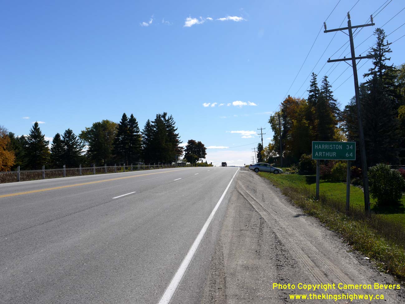
Left - Distance guide sign on eastbound Hwy 9 departing from Kincardine. See an
Enlarged Photo Here. (Photograph taken on September 27, 2018 - © Cameron Bevers) Right - Junction sign assembly facing northbound traffic on the Hwy 21 Bypass approaching the Hwy 9 Junction in Kincardine. See an Enlarged Photo Here. (Photograph taken on September 27, 2018 - © Cameron Bevers) 

Left - Facing north along the Hwy 21 Bypass towards the Hwy 9 Junction in Kincardine. The Kincardine Bypass temporarily ended at this intersection between the
completion of the first phase of the bypass in 1979 and the completion of the second phase in 1981. Although Broadway Street (Old Hwy 9) continues west from Hwy 21
into Kincardine, Kincardine itself is not signed as a destination on the destination guide sign beside the highway at right. This is because northbound traffic on
Hwy 21 has already been advised to turn into town further south via Old Hwy 21 (Kincardine Avenue). See an
Enlarged Photo Here. (Photograph taken on September 27, 2018 - © Cameron Bevers) Right - View of the Kincardine Bypass (Hwy 21), facing south from the Hwy 9 Junction. Completed and opened to traffic in 1979, the south leg of the Kincardine Bypass is now quite built-up, with numerous commercial developments lining both sides of the Hwy 21 Bypass. See an Enlarged Photo Here. (Photograph taken on September 27, 2018 - © Cameron Bevers) 

Left - Facing east along Hwy 9 towards Walkerton from the Hwy 21 Bypass Junction in Kincardine. See an
Enlarged Photo Here. (Photograph taken on September 27, 2018 - © Cameron Bevers) Right - Green guide signs on westbound Hwy 9 approaching the Hwy 21 Bypass Junction. See an Enlarged Photo Here. (Photograph taken on September 27, 2018 - © Cameron Bevers) 

Left - Western terminus of Hwy 9 at the Hwy 21 Junction (Kincardine Bypass). Traffic continuing through this intersection will enter Kincardine on Broadway
Street. Prior to 1982, Hwy 9 continued further west into Kincardine via Broadway Street. See an
Enlarged Photo Here. (Photograph taken on September 27, 2018 - © Cameron Bevers) Right - Junction sign assembly marking the western terminus of Hwy 9 in Kincardine. Interestingly, this is the exact same point where provincial jurisdiction over Hwy 9 ended more than a century ago, when the Kincardine to Walkerton Road was assumed as a provincial highway on July 8, 1920. Provincial jurisdiction over Hwy 9 was extended westerly into Kincardine when the DHO constructed a new bridge over the nearby North Penetangore River in 1931. See an Enlarged Photo Here. (Photograph taken on September 27, 2018 - © Cameron Bevers) 

Left - Fingerboard guide signs and junction sign assembly facing eastbound traffic, marking the Hwy 9 & Hwy 21 Junction in Kincardine. See an
Enlarged Photo Here. (Photograph taken on September 27, 2018 - © Cameron Bevers) Right - Junction sign assembly facing northbound traffic on the Kincardine Bypass (Hwy 21). Between 1979 and 1981, northbound traffic on Hwy 21 had to temporarily turn left and follow Hwy 9 (Broadway Street) while the north leg of the Kincardine Bypass was being completed. Following the completion of the second phase of the Kincardine Bypass in 1981, the old route of Hwy 9 & Hwy 21 leading into Kincardine was transferred to municipal jurisdiction. See an Enlarged Photo Here. (Photograph taken on September 27, 2018 - © Cameron Bevers) 

Left - Facing north along the Kincardine Bypass (Hwy 21) from the Hwy 9 Junction. Although scarcely 800 metres in length, the north leg of the Kincardine
Bypass provided a far more efficient and direct route for through traffic on Hwy 21. The old route of Hwy 21 at Kincardine's northeast entrance was quite awkward and
did not favour traffic heading anywhere but the Kincardine town centre. Overall, the Hwy 21 Bypass around Kincardine shortened the distance via Hwy 21 between
Goderich and Owen Sound by almost 3 km. See an Enlarged Photo Here. (Photograph taken on September 27, 2018 - © Cameron Bevers) Right - Junction of Hwy 9 and the Hwy 21 Bypass, facing south. Prior to 1981, this was a three-leg T-intersection. The section of the Kincardine Bypass lying to the south of Hwy 9 was an existing municipal road assumed by the Ministry of Transportation and upgraded to a King's Highway during the late 1970s. However, the north leg of the Kincardine Bypass lying north of Hwy 9 was entirely new construction under Contract #1980-46, where no road previously existed. See an Enlarged Photo Here. (Photograph taken on September 27, 2018 - © Cameron Bevers) 

Left - This interesting municipal street name sign at the Hwy 9 & Hwy 21 Junction indicates that Hwy 9 is a "Heritage Highway", indicated by the wagon wheel
logo. Prior to the 1990s, certain provincial highways were signs as tourist routes. The Heritage Highway wagon wheel logo was used on several highways in Ontario, but
I was not aware that Hwy 9 was among them. The section of Hwy 9 from Kincardine to Walkerton does follow the historical route of the Durham Road - a 19th Century
wagon road built to open up this part of Ontario to settlement and farming. See an
Enlarged Photo Here. (Photograph taken on September 27, 2018 - © Cameron Bevers) Right - Hwy 9 Ends sign and Hwy 21 junction sign assembly at the Hwy 9 & Hwy 21 Junction in Kincardine. See an Enlarged Photo Here. (Photograph taken on September 27, 2018 - © Cameron Bevers) 

Left - Approaching the Hwy 21 Bypass Junction on Broadway Street (Old Hwy 9), facing east. See an
Enlarged Photo Here. (Photograph taken on September 27, 2018 - © Cameron Bevers) Right - Facing west along Old Hwy 9 (Broadway Street) from the Kincardine Bypass (Hwy 21). Prior to a jurisdictional transfer in 1982, this section of Broadway Street was a part of Hwy 9. The street is now maintained by the Municipality of Kincardine. At left, a long row of 1960s-era DHO luminaires provide plenty of evidence that this was once a King's Highway. See an Enlarged Photo Here. (Photograph taken on September 27, 2018 - © Cameron Bevers) 

Left - Manufacturer's plaque on the old DHO luminaires along Old Hwy 9 (Broadway Street), which indicates that they were manufactured and installed in 1964.
See an Enlarged Photo Here. (Photograph taken on September 27, 2018 - © Cameron Bevers) Right - Junction sign assembly facing eastbound traffic of Old Hwy 9 (Broadway Street) approaching the Hwy 21 Bypass Junction. See an Enlarged Photo Here. (Photograph taken on September 27, 2018 - © Cameron Bevers) 

Left - At Broadway Street, Old Hwy 21 turned right from Queen Street and began to head northeasterly out of town. Today, a pair of "TO 9" & "TO 21"
green-and-white trailblazer route markers direct traffic along Broadway Street and out to the Hwy 21 Bypass and Hwy 9. At one time, both Hwy 9 & Hwy 21 were
signed as a concurrent overlapped route at the northeast entrance to Kincardine, but the overlapped route was discontinued in 1962. See an
Enlarged Photo Here. (Photograph taken on September 27, 2018 - © Cameron Bevers) Right - Facing south along Queen Street (Old Hwy 21) from Broadway Street. See an Enlarged Photo Here. (Photograph taken on September 27, 2018 - © Cameron Bevers) 

Left - Facing east along Broadway Street (Old Hwy 21) from Queen Street in Kincardine. Ultimately, Broadway Street becomes Hwy 9 east of the Kincardine Bypass.
See an Enlarged Photo Here. (Photograph taken on September 27, 2018 - © Cameron Bevers) Right - View of Broadway Street approaching Downtown Kincardine, facing west from William Street. Prior to the completion of the first phase of the Kincardine Bypass in 1979, Hwy 21 turned left onto Queen Street at the traffic signals in the background. See an Enlarged Photo Here. (Photograph taken on September 27, 2018 - © Cameron Bevers) 

Left - Facing west along Broadway Street (Old Hwy 21) from Charles Street in Kincardine. At one time, provincial jurisdiction over Hwy 21 resumed at this
intersection as it was historically the end of Kincardine's urbanized area. Kincardine's urbanized limits today extend all the way out to, and even beyond, the
Kincardine Bypass (Hwy 21 New). See an Enlarged Photo Here. (Photograph taken on September 27, 2018 - © Cameron Bevers) Right - View of Broadway Street (Old Hwy 21) facing east from Charles Street towards the historical junction of Hwy 9 & Hwy 21 at the northeast entrance to Kincardine. See an Enlarged Photo Here. (Photograph taken on September 27, 2018 - © Cameron Bevers) 

Left - Facing west along Old Hwy 21 (Broadway Street) from Old Hwy 9. A horse-drawn carriage travelling westbound along Broadway Street is anachronistically
juxtaposed in front of two patrons shopping at a car dealership. There are several large Old Order Mennonite and Amish communities in Southwestern Ontario who quite
happily choose to live without modern innovations and lifestyles. Even today, horse-drawn carriages are frequently seen on roads in the Kincardine area. See an
Enlarged Photo Here. (Photograph taken on September 27, 2018 - © Cameron Bevers) Right - Approaching the Old Hwy 9 Junction on Old Hwy 21, facing north along Sutton Street. Until the early 1980s, Hwy 9 forked to the right and continued east towards Walkerton via Broadway Street, while Hwy 21 continued straight ahead towards Port Elgin via Sutton Street. Although northbound motorists can still access the Hwy 21 Bypass by continuing straight ahead on Sutton Street, the route trailblazed to Hwy 9 & Hwy 21 is via the channelized ramp departing at right. See an Enlarged Photo Here. (Photograph taken on September 27, 2018 - © Cameron Bevers) 

Left - Former junction of Hwy 9 & Hwy 21 at the northeastern entrance to Kincardine. The junction of these two highways has actually existed in three
different locations since this section of Hwy 21 was first established in 1935. The original junction of Hwy 9 & Hwy 21 was situated between the junction seen
here and the present-day junction of Hwy 9 and the Hwy 21 Bypass. See an Enlarged Photo Here. (Photograph taken on September 27, 2018 - © Cameron Bevers) Right - Approaching the old western terminus of Hwy 9 at the intersection of Broadway Street and Sutton Street. Prior to 1962, Hwy 9 turned left and continued west along Broadway Street into Downtown Kincardine concurrently with Hwy 21. The overlapped route of Hwy 9 & Hwy 21 into Downtown Kincardine was discontinued in 1962. Accordingly, the route of Hwy 9 ended at this intersection from 1962 until 1982, when provincial jurisdiction over Hwy 9 was truncated at the Hwy 21 Bypass. See an Enlarged Photo Here. (Photograph taken on September 27, 2018 - © Cameron Bevers) 

Left - Facing east along Old Hwy 9 (Broadway Street) from Sutton Street (Old Hwy 21). Broadway Street connects to the Hwy 21 Bypass about 1 km ahead. For a
brief period of time in the late 1970s and early 1980s, Hwy 21 was temporarily signed alongside Hwy 9 on this section of Broadway Street. This was a temporary
stopgap measure which was put in place until the second phase of the Kincardine Bypass north of the Hwy 9 Junction was completed and opened to traffic in 1981. See an
Enlarged Photo Here. (Photograph taken on September 27, 2018 - © Cameron Bevers) Right - Intersection of Sutton Street (Old Hwy 21) and Broadway Street (Old Hwy 9 & Old Hwy 21), facing south towards Downtown Kincardine. Provincial jurisdiction over the Kincardine northeast entrance highways ceased in 1982, when ownership of Old Hwy 9 & Old Hwy 21 was transferred to the Town of Kincardine. See an Enlarged Photo Here. (Photograph taken on September 27, 2018 - © Cameron Bevers) 
Above - This pair of "TO 9" and "TO 21" green-and-white trailblazer route markers have likely stood since the Hwy 21 Bypass was completed in the early 1980s.
See an Enlarged Photo Here. (Photograph taken on September 27, 2018 - © Cameron Bevers) 

Left - Facing north along Old Hwy 21 (Sutton Street) from Broadway Street (Old Hwy 9). This long, empty left-turn lane along Sutton Street is likely a remnant
from Kincardine's pre-bypass days, when southbound Hwy 21 traffic would have to turn left here in order to head east on Hwy 9 towards Walkerton. See an
Enlarged Photo Here. (Photograph taken on September 27, 2018 - © Cameron Bevers) Right - Penetangore River Bridge on Old Hwy 9 in Kincardine. Structure completed in 1931. See an Enlarged Photo Here. (Photograph taken on June 19, 2005 - © Cameron Bevers) 

Left - As established in 1935, Hwy 21 followed North Street to the intersection of Broadway Street (Old Hwy 9), seen here. The route of Hwy 21 then turned
right onto Broadway Street and ran concurrently with Hwy 9 into Kincardine. This old route of Hwy 21 was bypassed by an improved highway alignment in the late 1930s.
Jurisdiction over the old route of Hwy 21 via North Street reverted to municipal control several years later, in 1953. See an
Enlarged Photo Here. (Photograph taken on September 27, 2018 - © Cameron Bevers) Right - Facing east along Broadway Street (Old Hwy 9) approaching North Street (the original 1935 route of Hwy 21). Early motorists on Hwy 21 had to turn left here to continue north along Hwy 21 towards Port Elgin. Through traffic continued east via Hwy 9 towards Walkerton. See an Enlarged Photo Here. (Photograph taken on September 27, 2018 - © Cameron Bevers) 

Left - With its vintage 1960s DHO luminaires still in place, Broadway Street (Old Hwy 9) still looks very much like an old King's Highway. Jurisdiction over
this section of Hwy 9 was transferred from the province to the Town of Kincardine in 1982, following the completion of the Hwy 21 Bypass. At right, the original 1935
route of Hwy 21 via North Street can be seen joining into Broadway Street. See an
Enlarged Photo Here. (Photograph taken on September 27, 2018 - © Cameron Bevers) Right - Facing west along Broadway Street (Old Hwy 9) approaching Sutton Street (Old Hwy 21). It is interesting to note that there have been two times where Hwy 9 & Hwy 21 were briefly signed concurrently along this section of Broadway Street - once from 1935 until 1939 and again between 1979 and 1981. See an Enlarged Photo Here. (Photograph taken on September 27, 2018 - © Cameron Bevers)
More King's Highway 9 Photographs Coming Soon!
|
|---|
Links to Adjacent King's Highway Photograph Pages:
Back to King's Highway 8 Photos /
King's Highway 9 History /
On to King's Highway 10 Photos
Ontario Highway History - Main Menu / Back to List of Highways Website contents, photos & text © 2002-2026, Cameron
Bevers (Webmaster) - All Rights Reserved / Contact Me
|
|---|