| 
|  |
|
|
This page contains photographs of British Columbia's Highway 3 (Crowsnest Highway), arranged by location from Elko westerly to
the Fort Steele Interchange east of Cranbrook. All photographs displayed on this page were taken by the Webmaster (Cameron Bevers). To view photos of other British
Columbia Highways, please select a highway number listed on the
British Columbia Photograph Index Page. Click on any thumbnail to see a larger image!
Please note that all photographs displayed on this website are protected by copyright. These photographs must not be
reproduced, published, electronically stored or copied, distributed, or posted onto other websites without my written permission. If you want to use photos from this
website, please email me first for permission. Thank-you!
|
|---|
|
Page 1: BC Highway 3 (Crowsnest Highway) Photographs: Elko to the Fort Steele Interchange


Left - Facing west along Hwy 3 & Hwy 93 about 2 km east of the Fort Steele Interchange. A bright red promotional billboard sign beside the highway
advertises the nearby ski resort town of Kimberley, which can be accessed via Hwy 95A north of Cranbrook. See an
Enlarged Photo Here. (Photograph taken on June 7, 2017 - © Cameron Bevers) Right - Distance guide sign on eastbound Hwy 3 & Hwy 93 east of the Fort Steele Interchange. Lethbridge is located in the neighbouring province of Alberta. See an Enlarged Photo Here. (Photograph taken on June 7, 2017 - © Cameron Bevers) 

Left - Distance guide sign on westbound Hwy 3 & Hwy 93 east of the Fort Steele Interchange. See an
Enlarged Photo Here. (Photograph taken on June 7, 2017 - © Cameron Bevers) Right - Advance green guide sign on westbound Hwy 3 & Hwy 93 approaching the Fort Steele Interchange (Junction of Hwy 3, Hwy 93 & Hwy 95). This important interchange is a key decision point for motorists entering British Columbia via the Crowsnest Pass from neighbouring Alberta. Motorists can turn north here via the Kootenay Highway (Hwy 93 & Hwy 95) to Radium Hot Springs and Golden, where they can join the Trans-Canada Highway (Hwy 1). Motorists who continue west via the Crowsnest Highway will reach Cranbrook, Castlegar and the Okanagan Valley. The Crowsnest Highway also connects back to Hwy 1 in Hope, located about 150 km east of Vancouver. See an Enlarged Photo Here. (Photograph taken on June 7, 2017 - © Cameron Bevers) 

Left - Old guide sign at the Fort Steele Interchange showing the British Columbia highway routes of the Cranbrook area. See an
Enlarged Photo Here. (Photograph taken on June 7, 2017 - © Cameron Bevers) Right - Dual Hwy 3 & Hwy 93 route markers near the Fort Steele Interchange. These two highways share an overlapped concurrent route for a distance of approximately 55 km between the Cranbrook area and Elko. From the Hwy 3 & Hwy 93 Junction near Elko, Hwy 3 continues east and heads across the Crowsnest Pass into Alberta, while Hwy 93 turns south towards the U.S. Boundary, where it enters Montana at the Roosville Border Crossing Point. See an Enlarged Photo Here. (Photograph taken on June 7, 2017 - © Cameron Bevers) 

Left - Facing east along Hwy 3 & Hwy 93 towards Elko from the Fort Steele Interchange. See an
Enlarged Photo Here. (Photograph taken on June 7, 2017 - © Cameron Bevers) Right - Green guide sign on westbound Hwy 3 & Hwy 93 at the Fort Steele Interchange. At this point, Hwy 93 exits from the Crowsnest Highway (Hwy 3) and heads north towards Radium Hot Springs concurrently with Hwy 95. Interestingly, all three approaches to the Fort Steele Interchange are overlapped highway routes. Hwy 3 & Hwy 95 approach the interchange from the west, Hwy 3 & Hwy 93 approach from the southeast, while Hwy 93 & Hwy 95 approach from the north. See an Enlarged Photo Here. (Photograph taken on June 7, 2017 - © Cameron Bevers) 

Left - Facing north along the Kootenay Highway (Hwy 93 & Hwy 95) towards Radium Hot Springs from the Fort Steele Interchange. The small community of Fort
Steele actually lies about 6 km north of the highway interchange. The hazy peaks of the Purcell Mountains can be seen in the distance. See an
Enlarged Photo Here. (Photograph taken on June 6, 2017 - © Cameron Bevers) Right - Grade separation at the Fort Steele Interchange. The Crowsnest Highway (Hwy 3) is carried over the ramp connection to Hwy 93 & Hwy 95. See an Enlarged Photo Here. (Photograph taken on June 6, 2017 - © Cameron Bevers) 

Left - Dual Hwy 93 & Hwy 95 route markers on the westbound-to-northbound ramp at the Fort Steele Interchange. See an
Enlarged Photo Here. (Photograph taken on June 7, 2017 - © Cameron Bevers) Right - Guide sign on southbound Hwy 93 & Hwy 95 at the Fort Steele Interchange. After travelling along an overlapped concurrent route since Radium Hot Springs, Hwy 93 & Hwy 95 part ways at the Fort Steele Interchange. Hwy 93 joins Hwy 3 East and heads southeasterly to Elko, while Hwy 93 joins Hwy 3 West and heads westerly to Cranbrook. See an Enlarged Photo Here. (Photograph taken on June 7, 2017 - © Cameron Bevers) 

Left - Dual Hwy 3 & Hwy 93 route markers on the southbound-to-eastbound ramp at the Fort Steele Interchange. With so many overlapped routes approaching the
interchange, each ramp is well-signed with reassurance route markers. See an
Enlarged Photo Here. (Photograph taken on June 6, 2017 - © Cameron Bevers) Right - Dual Hwy 3 & Hwy 95 route markers on the southbound-to-westbound ramp at the Fort Steele Interchange. See an Enlarged Photo Here. (Photograph taken on June 6, 2017 - © Cameron Bevers) 

Left - Overhead guide sign marking the exit ramp to Cranbrook (Hwy 3 West & Hwy 95 South) at the Fort Steele Interchange. See an
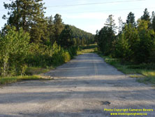
Enlarged Photo Here. (Photograph taken on June 6, 2017 - © Cameron Bevers) Right - Abandoned Hwy 3 & Hwy 93 Junction near the Fort Steele Interchange. Originally, these two highways met at a "Y" junction. The former highway junction now lies abandoned in the forest a short distance northeast of the current highway interchange. See an Enlarged Photo Here. (Photograph taken on June 7, 2017 - © Cameron Bevers) 

Left - An abandoned former alignment of the Crowsnest Highway lies a short distance north of the Fort Steele Interchange. See an
Enlarged Photo Here. (Photograph taken on June 6, 2017 - © Cameron Bevers) Right - A small roadside turnout on Hwy 93 & Hwy 95 at the Fort Steele Interchange allows motorists to observe a particularly dramatic range of the Rocky Mountains known as "The Steeples". See an Enlarged Photo Here. (Photograph taken on June 6, 2017 - © Cameron Bevers) 

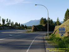
Left - Motorists are greeted with an unforgettable vista of the Rocky Mountains as the Crowsnest Highway (Hwy 3), curves through the Fort Steele Interchange.
See an Enlarged Photo Here. (Photograph taken on June 6, 2017 - © Cameron Bevers) Right - Dual Hwy 3 & Hwy 93 route markers on the eastbound Crowsnest Highway at the Fort Steele Interchange. See an Enlarged Photo Here. (Photograph taken on June 6, 2017 - © Cameron Bevers) 

Left - Dual Hwy 93 & Hwy 95 route markers on the eastbound-to-northbound ramp at the Fort Steele Interchange. See an
Enlarged Photo Here. (Photograph taken on June 6, 2017 - © Cameron Bevers) Right - Green guide signs on eastbound Hwy 3 & Hwy 95 marking the upcoming Fort Steele Interchange. At this point, Hwy 95 exits from the Crowsnest Highway and heads north towards Radium Hot Springs concurrently with Hwy 93 North. Motorists who continue east along the Crowsnest Highway through the interchange will also connect to Hwy 93 South. See an Enlarged Photo Here. (Photograph taken on June 6, 2017 - © Cameron Bevers) 

Left - Advance green guide sign on eastbound Hwy 3 & Hwy 95 approaching the Fort Steele Interchange located east of Cranbrook. See an
Enlarged Photo Here. (Photograph taken on June 6, 2017 - © Cameron Bevers) Right - Facing west along Hwy 3 & Hwy 95 towards Cranbrook from the Fort Steele Interchange. See an Enlarged Photo Here. (Photograph taken on June 7, 2017 - © Cameron Bevers)
Continue west along BC Highway 3 from Fort Steele Interchange to Curzon Junction |
|---|
Links to Adjacent BC Highway Photograph Pages:
Back to BC Highway 1 Photos /
British Columbia Highways Photo Index /
On to BC Highway 3A Photos
Ontario Highway History - Home / Vacation Highway Photos - Home Website contents, photos & text © 2002-2024, Cameron
Bevers (Webmaster) - All Rights Reserved / Contact Me |
|---|