History of Secondary Highway 564:
Secondary Highway 564 is a local highway in the District of Timiskaming that provides access from Highway 112 to the small community of Boston Creek, located south
of Kirkland Lake. Highway 564 was first designated by an Order-in-Council dated May 9, 1956. The route was first depicted on a Preliminary Route Plan prepared by the
Department of Highways of Ontario (DHO) in June 1956. The new highway was originally 8.2 miles (13.2 km) in length. The route remained more or less the same up until
1969, when a section of Highway 564 was legally re-designated as a Tertiary Highway. On October 16, 1969, the easternmost section of Highway 564 was renumbered as
Highway 809. As a result of this renumbering, the length of Highway 564 was reduced to 10.6 km. In the mid-1980s, the Ministry of Transportation and Communications
(MTC) relinquished jurisdiction and control over Highway 809 through Pacaud Township, as well as a 3.6 km section of Highway 564 lying east of Boston Creek. An
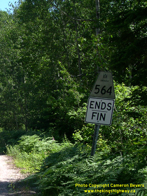
Order-in-Council was passed on November 1, 1984, which formally removed the provincial highway designation along the section of the route lying east of Boston Creek.
Since 1984, Highway 564 has ended at Boston Creek, 7 km east of the Highway 112 Junction. The entire route of Highway 564 is still gravel-surfaced today. Unless
posted otherwise, the speed limit on Highway 564 is 80 km/h (50 mph). There are no services available on this highway.
|