
| 
| |
|
|
This page contains present day photos (Year 2000 to date) of Ontario's King's Highway 17, arranged by location from Marathon
northerly to Terrace Bay. All photographs displayed on this page were taken by the Webmaster (Cameron Bevers), unless specifically noted otherwise. Click on any
thumbnail to see a larger image!
Please note that all photographs displayed on this
website are protected by copyright. These photographs must not be reproduced, published,
electronically stored or copied, distributed, or posted onto other websites without
my written permission. If you want to use photos from this website, please
email me first for permission. Thank-you!
|
|---|
|
Page 31: Present Day King's Highway 17 Photographs (Marathon to Terrace Bay)


Left - Hwy 17 winds up through the rugged Seeley Mountains north of Marathon. See an Enlarged Photo here. (Photograph taken on August 30, 2003 - © Cameron Bevers) Right - Facing south along Hwy 17 in the Seeley Mountains north of Marathon. (Photograph taken on August 29, 2006 - © Cameron Bevers) 

Left - The north shore of Lake Superior features some of Ontario's most rugged terrain. Building Hwy 17 through this terrain was a tremendous
engineering feat, one which cannot possibly be captured through my photography. The only way to get a true feel of the difficult, inhospitable terrain that
the highway builders encountered along the north shore is to drive the highway in person. (Photograph taken on August 30, 2003 - © Cameron Bevers) Right - Facing north along Hwy 17 as it passes beneath the Seeley Mountains north of Marathon. (Photograph taken on August 30, 2003 - © Cameron Bevers) 

Left - Hwy 17 at Wolf Camp Lake north of Marathon. (Photograph taken on August 30, 2003 - © Cameron Bevers) Right - A fine mist enshrouds Hwy 17 north of Marathon. The north shore of Lake Superior is famous for its unpredictable maritime-like weather and chronic fog. (Photograph taken on September 4, 2004 - © Cameron Bevers) 

Left - Concrete barrel arch culvert at Mink Creek north of Marathon. Structure completed in 1951. (Photograph taken on September 4, 2004 - © Cameron Bevers) Right - Excessive erosion has caused a partial failure of the Mink Creek Culvert. The culvert has been retrofitted with steel braces to retain its arched shape. This structure will likely be replaced during a Hwy 17 reconstruction project scheduled for 2007. (Photograph taken on September 4, 2004 - © Cameron Bevers) 

Left - View of Hwy 17 between Neys Provincial Park and the Little Pic River Bridge, facing south towards Marathon. See an
Enlarged Photo here. (Photograph taken on August 29, 2006 - © Cameron Bevers) Right - View from the Little Pic River Lookout on Hwy 17 between Marathon and Terrace Bay. The massive Little Pic River Bridge can be seen in the background. Note the transport truck on the bridge for scale. (Photograph taken on August 29, 2006 - © Cameron Bevers) 

Left - Facing north along Hwy 17 between Neys Provincial Park and the Little Pic River Bridge. The near vertical walls of the Little Pic River
Canyon are visible in the distance. Crossing the Little Pic River was one of the greatest engineering challenges encountered while building the Lake
Superior section of the Trans-Canada Highway. This crossing was especially complicated, since the north side of the canyon is significantly higher and
steeper than the south side of the canyon. Invariably, a steep grade had to be accommodated into the design of the crossing. (Photograph taken on August 29, 2006 - © Cameron Bevers) Right - Approaching the Little Pic River Bridge on Hwy 17 between Marathon and Terrace Bay, facing north. (Photograph taken on August 29, 2006 - © Cameron Bevers) 

Left - A former alignment of Hwy 17 branches off of the existing highway just south of the Little Pic River Bridge. The old highway leads to the
site of a Bailey Bridge, which existed for a few years during the 1950s while Hwy 17 was being pushed southwards through the remote forests between Terrace
Bay and Marathon. The old Bailey Bridge once stood a short distance upstream from the current highway bridge's location. (Photograph taken on August 29, 2006 - © Cameron Bevers) Right - The pavement was removed on the first section of the abandoned Hwy 17 alignment, but the rest of the old highway is paved down to the former Bailey Bridge site. (Photograph taken on August 29, 2006 - © Cameron Bevers) 

Left - Abandoned section of Hwy 17 leading to the old Little Pic River Bailey Bridge. This temporary crossing was used by all traffic on Hwy 17
from 1953 until the permanent bridge was completed over the Little Pic River in 1958. (Photograph taken on August 29, 2006 - © Cameron Bevers) Right - Dusk sets in over the Little Pic River at the site of the former Bailey Bridge. The current Hwy 17 Bridge can be seen in the distance. (Photograph taken on August 29, 2006 - © Cameron Bevers) 

Left - Facing south along Hwy 17 from the Little Pic River Bridge. A curve was realigned slightly here to improve the highway's geometry. (Photograph taken on August 29, 2006 - © Cameron Bevers) Right - Facing north along Hwy 17 towards Terrace Bay at the Little Pic River Bridge. The highway ascends a steep uphill grade across the structure. (Photograph taken on August 29, 2006 - © Cameron Bevers) 

Left - Little Pic River Bridge on Hwy 17, facing south towards Marathon. Two oversized curve warning signs with an 80 km/h advisory speed were
placed on the approach to the curve at the south end of the structure. See an Enlarged Photo here. (Photograph taken on August 29, 2006 - © Cameron Bevers) Right - View of the Little Pic River Bridge on Hwy 17. Constructing the highway through this area was one of the greatest challenges of building the Trans-Canada Highway around Lake Superior. The near-vertical walls of the Little Pic River Canyon forced highway engineers to select this exact location for Hwy 17 to cross the river, where the canyon walls were not quite as severe. However, in order to fit the highway into this crossing location, it had to be designed with a comparatively sharp curve at the bottom of a long downhill grade. Note the logarithmic transverse white lines on the southbound lane, which were placed in an effort to get motorists to slow down as they approach the curve. (Photograph taken on August 29, 2006 - © Cameron Bevers) 
Above - Western side of the Little Pic River Bridge on Hwy 17 between Marathon and Terrace Bay. This massive structure is 685 feet in length (209
metres) and rises 130 feet (40 metres) above the Little Pic River. At a cost of over $2 million (in 1958 dollars), this was the most expensive bridge built
on the Lake Superior section of the Trans-Canada Highway. See an Enlarged Photo here. (Photograph taken on August 29, 2006 - © Cameron Bevers) 

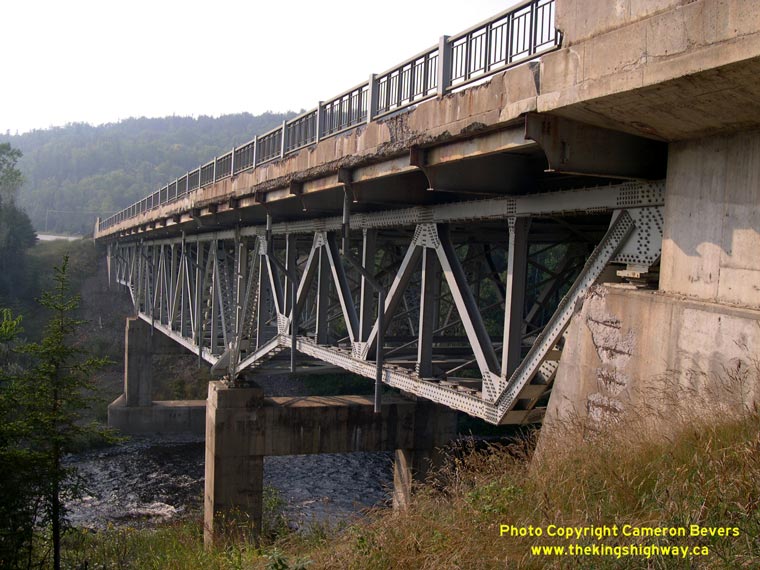
Left - Eastern side of the Little Pic River Bridge on Hwy 17. The Little Pic River Bridge is a Warren-type deck truss structure. (Photograph taken on August 29, 2006 - © Cameron Bevers) Right - Below-deck view of the Little Pic River Bridge truss superstructure. (Photograph taken on August 29, 2006 - © Cameron Bevers) 

Left - An abandoned section of Hwy 17 lies on the western side of the Little Pic River Bridge. Prior to the completion of the permanent bridge over
the Little Pic River, this former highway alignment turned 90 degrees and led precariously down the side of the canyon to reach the former Bailey Bridge site. (Photograph taken on August 29, 2006 - © Cameron Bevers) Right - The former alignment of Hwy 17 on the eastern side of the Little Pic River Bridge is now so overgrown that it is barely noticeable. It may seem hard to believe, but this tiny gap in the trees was once Hwy 17. The old highway has been closed to traffic since the permanent Little Pic River Bridge was opened to traffic in December, 1958. (Photograph taken on August 29, 2006 - © Cameron Bevers) 

Left - Concrete barrel arch culvert at Dead Horse Creek between Coldwell and Jackfish. Structure completed in 1953. (Photograph taken on September 4, 2004 - © Cameron Bevers) Right - Western side of the Steel River Bridge on Hwy 17 south of Terrace Bay. Structure completed in 1958. See an Enlarged Photo here. (Photograph taken on September 4, 2004 - © Cameron Bevers) 
Left - The design of the parapet walls on the Steel River Bridge are very unusual. I do not know of any other bridges in Ontario built with these
parapets. The unusual parapets do give the bridge a distinctively streamlined appearance, quite unlike most bridges built in Ontario during the 1950s. Also
note the concrete deck surface, which was never overlaid with asphalt. (Photograph taken on September 4, 2004 - © Cameron Bevers) Right - The Steel River Bridge is a Warren-type deck truss, and is one of the most interesting bridges on Hwy 17. Sadly, this magnificent structure has been scheduled for demolition and replacement in 2008. See an Enlarged Photo here. (Photograph taken on September 4, 2004 - © Cameron Bevers) 

Left - Facing north along Hwy 17 towards Terrace Bay at the Steel River Bridge. (Photograph taken on September 4, 2004 - © Cameron Bevers) Right - Facing south along Hwy 17 towards Marathon at the Steel River Bridge. (Photograph taken on September 4, 2004 - © Cameron Bevers) 

Left - Eastern side of the Steel River Bridge on Hwy 17 south of Terrace Bay. (Photograph taken on September 4, 2004 - © Cameron Bevers) Right - Below-deck view of the Steel River Bridge truss superstructure. (Photograph taken on August 29, 2006 - © Cameron Bevers) 

Left - Facing north along Hwy 17 towards Jackfish Lake from the Santoy Mountains near Terrace Bay. See an
Enlarged Photo here. (Photograph taken on August 30, 2003 - © Cameron Bevers) Right - Facing south along Hwy 17 towards the Santoy Mountains from Jackfish Lake east of Terrace Bay. See an Enlarged Photo here. (Photograph taken on August 30, 2003 - © Cameron Bevers) 
Above - Reverse curve on Hwy 17 at Canoe Lake east of Terrace Bay. See an
Enlarged Photo here. (Photograph taken on August 29, 2006 - © Cameron Bevers)
Continue on to King's Highway 17 Photos: Terrace Bay to Selim Hill
|
|---|
Links to Adjacent King's Highway Photograph Pages:
Back to Hwy 17 - White River to Marathon
Hwy 17 Photo Index
On to Hwy 17 - Terrace Bay to Selim Hill
Back to King's Highway 16 Photos /
King's Highway 17 History /
On to King's Highway 18 Photos
Ontario Highway History - Main Menu / Back to List of Highways Website contents, photos & text © 2002-2026, Cameron
Bevers (Webmaster) - All Rights Reserved / Contact Me
|
|---|