
| 
| |
|
|
This page contains historical photos of Ontario's King's Highway 17 dating from 1960 to 1964. All photographs displayed on
this page were taken by the Ontario Ministry of Transportation, unless specifically noted otherwise. Historical photographs are arranged in approximate chronological
order. Click on any thumbnail to see a larger image!
Please note that all photographs displayed on this
website are protected by copyright. These photographs must not be reproduced, published,
electronically stored or copied, distributed, or posted onto other websites without
my written permission. If you want to use photos from this website, please
email me first for permission. Thank-you!
|
|---|
|
Page 6: Historical King's Highway 17 Photographs (1960 to 1964)


Left - Postcard showing the massive Little Pic River Bridge on Hwy 17 near Marathon (ca. 1960). See an
Enlarged Photo Here. (Photo courtesy of H.R. Oakman) Right - Circa 1960 postcard view of the Great River Road Monument at the Hwy 17 & Hwy 71 Junction at Longbow Corners east of Kenora. See an Enlarged Photo Here. (Photo courtesy of Alex Wilson Publications Ltd.) 

Left - Postcard view of the Keewatin Channel Bridge on Hwy 17 west of Kenora (ca. 1960) (Photo courtesy of Western Smallware & Stationery Co.) Right - Autumn view of Duchesnay Falls on the Hwy 17 Bypass west of North Bay (1960) (Photo courtesy of William Forder) 
Above - Postcard view of Cumberland Street (Hwy 11 & Hwy 17) in Downtown Port Arthur in 1960, facing north towards the Hwy 11A & Hwy 17A Junction. This
wonderful photo shows a busy downtown street scene at Cumberland Street and Arthur Street (today's Red River Road). Prior to the construction of the Lakehead
Expressway (today's Thunder Bay Expressway) in the late 1960s, all east-west through traffic had to pass through Port Arthur on either Hwy 11 & Hwy 17 or the
signed alternate route via Hwy 11A & Hwy 17A. This 1960 photo was taken shortly after the Hwy 11 designation was extended westerly from the route's former
terminus at Nipigon. Note the newly-installed dual Hwy 11 & Hwy 17 route markers on the green pole at left. It is also interesting to note that The Camera Shop,
whose staff photographers captured some of the most important highway construction achievements in Northwestern Ontario's history, is located across the street behind
the red city bus. From the 1930s up until about 1960, The Camera Shop published hundreds of photographs of Northwestern Ontario's highways as souvenir postcards for
tourists, some of which are featured on my website. Today, these souvenir postcards offer historians a unique historical perspective into the development of the
area's highway network. See an Enlarged Photo here. (Photo courtesy of Alex Wilson Publications Ltd.) 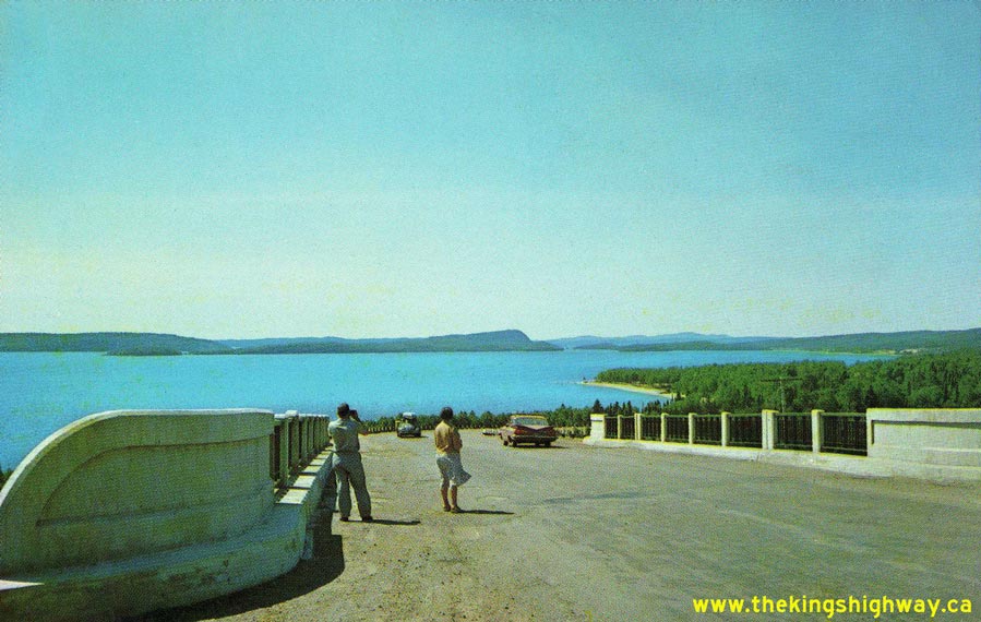

Left - Motorists enjoying the view of Lake Superior from Selim Hill on Hwy 17 near Schreiber in 1960. The completion of Hwy 17 around Lake Superior in
September, 1960 opened up this beautiful region of Ontario to tourism. Prior to that time, this vast area was essentially known only to local residents. See an
Enlarged Photo Here. (Photo courtesy of Dan Gibson) Right - Circa 1960 postcard view of the directional sign for Fort William at Hwy 17 and King Street at the entrance to Dryden. The Lakehead Cities of Port Arthur and Fort William, along with the former municipalities of Neebing and McIntyre were amalgamated into the new City of Thunder Bay in 1970. See an Enlarged Photo Here. (Photo courtesy of Alex Wilson Publishing, Dryden) 


Left - Paving operations on Hwy 17 through Lake Superior Provincial Park (1960) (Photo courtesy of Ontario Ministry of Transportation - © King's Printer for Ontario, 1960) Centre - View of the Montreal River from Hwy 17 north of Sault Ste. Marie (1960) (Photo courtesy of Ontario Ministry of Transportation - © King's Printer for Ontario, 1960) Right - West White River Bridge on Hwy 17 near White River (1960) (Photo courtesy of Ontario Ministry of Transportation - © King's Printer for Ontario, 1960) 

Left - Aerial view of the Michipicoten River Bridge on Hwy 17 south of Wawa. This photograph was taken only a few days after the highway was opened
to traffic in September 1960. The completion of the Trans-Canada Highway at Wawa marked the end of one of the largest highway construction projects in
Ontario's history. See an Enlarged Photo Here. (Photo courtesy of Ontario Ministry of Transportation - © King's Printer for Ontario, 1960) Right - Motorists standing beside a Hwy 17 and Lake Superior Route Trans-Canada Highway route marker sign near Marathon (ca. 1960) (Photo from Cameron Bevers' historical photograph collection - Original photographer unknown) 

Left - North Bay Bypass (Hwy 17) approaching Duchesnay Creek, facing east towards North Bay (July 2, 1960) (Photo © Archives of Ontario - Series RG-14-162-5-166, Photo #453) Right - Newly-completed Cobden Railway Overhead on Hwy 17 between Pembroke and Cobden (June 14, 1961) (Photo © Archives of Ontario - Series RG-14-162-5-166, Photo #1381-6) 

Left - Facing south along Hwy 17 towards Cigar Lake, between Marathon and White River (1961) (Photo courtesy of Ontario Ministry of Transportation - © King's Printer for Ontario, 1961) Right - New rock cut on Hwy 17 at Kama Hill, facing north towards Nipigon (1961) (Photo courtesy of Ontario Ministry of Transportation - © King's Printer for Ontario, 1961) 

Left - Newly-completed section of Hwy 17 approaching Agawa Bay, north of Sault Ste. Marie (1961) (Photo courtesy of Ontario Ministry of Transportation - © King's Printer for Ontario, 1961) Right - Rock drilling operations to widen a rock cut on Hwy 17 near Cobden (1961) (Photo courtesy of Ontario Ministry of Transportation - © King's Printer for Ontario, 1961) 
Above - Paving operations on Hwy 17 west of Deep River (1961) (Photo courtesy of Ontario Ministry of Transportation - © King's Printer for Ontario, 1961) 
Above - Postcard view of the new Cavers Hill Rock Cut on Hwy 17, between Nipigon and Rossport in 1961. See an
Enlarged Photo Here. (Photo courtesy of Dan Gibson) 
Above - Completed Cavers Hill Rock Cut on Hwy 17 north of Rossport (1961) (Photo courtesy of Ontario Ministry of Transportation - © King's Printer for Ontario, 1961) 
Above - Circa 1963 postcard view of the Hwy 17 & Hwy 533 Junction in Downtown Mattawa. Note the old provincial park sign situated just beyond the junction
sign assembly, pointing the way to Antoine Provincial Park. This small provincial park was once located on the Ottawa River about 4 miles north of Mattawa. The park
ceased operation back in the 1980s. See an Enlarged Photo Here. (Photo courtesy of Len Leiffer) 
Above - New Wabigoon River Bridge nearing completion on Hwy 17 west of Dryden (1963) (Photo courtesy of Ontario Ministry of Transportation - © King's Printer for Ontario, 1963) 

Left - Reconstruction of Hwy 17, south of the Hwy 563 Junction at Batchawana Bay (1963) (Photo courtesy of Ontario Ministry of Transportation - © King's Printer for Ontario, 1963) Right - Reconstructed section of Hwy 17 New (Formerly Hwy 44) near Carp (1964) (Photo courtesy of Ontario Ministry of Transportation - © King's Printer for Ontario, 1964) 

Left - Paving crew on Hwy 17 between Rutherglen and the Hwy 531 Junction (1964) (Photo courtesy of Ontario Ministry of Transportation - © King's Printer for Ontario, 1964) Right - Laying granular base on Hwy 17 between Eau Claire Sideroad (Hwy 630) and Rutherglen (1964) (Photo courtesy of Ontario Ministry of Transportation - © King's Printer for Ontario, 1964)
Continue on to King's Highway 17 Photos: Historical Photos: 1965-1969
|
|---|
Links to Adjacent King's Highway Photograph Pages:
Back to Hwy 17 - Historical Photos (1957-1959)
Hwy 17 Photo Index
On to Hwy 17 - Historical Photos (1965-1969)
Back to King's Highway 16 Photos /
King's Highway 17 History /
On to King's Highway 18 Photos
Ontario Highway History - Main Menu / Back to List of Highways Website contents, photos & text © 2002-2026, Cameron
Bevers (Webmaster) - All Rights Reserved / Contact Me
|
|---|