
| 
| |
|
|
This page contains present day photos (Year 2000 to date) of Ontario's King's Highway 21, arranged by location from
Bayfield northerly to Amberley. All photographs displayed on this page were taken by the Webmaster (Cameron Bevers), unless specifically noted
otherwise. Click on any thumbnail to see a larger image!
Please note that all photographs displayed on this
website are protected by copyright. These photographs must not be reproduced, published,
electronically stored or copied, distributed, or posted onto other websites without
my written permission. If you want to use photos from this website, please
email me first for permission. Thank-you!
|
|---|
|
Page 4: Present Day King's Highway 21 Photographs (Bayfield to Amberley)


Left - Facing south towards Bayfield along Hwy 21 at the Gully Bridge. See an
Enlarged Photo Here. (Photograph taken on June 26, 2005 - © Cameron Bevers) Right - Western side of the Gully Bridge. This concrete arch bridge was completed in 1941. See an Enlarged Photo Here. (Photograph taken on June 26, 2005 - © Cameron Bevers) 

Left - Facing north towards Goderich along Hwy 21 at the Gully Bridge. See an
Enlarged Photo Here. (Photograph taken on June 26, 2005 - © Cameron Bevers) Right - Overgrown eastern side of the Gully Bridge on Hwy 21 south of Goderich. See an Enlarged Photo Here. (Photograph taken on June 26, 2005 - © Cameron Bevers) 

Left - Close-up of the western side of the Gully Bridge on Hwy 21. See an
Enlarged Photo Here. (Photograph taken on June 26, 2005 - © Cameron Bevers) Right - Replacement of a 1930s concrete culvert on Hwy 21 north of Bayfield. See an Enlarged Photo Here. (Photograph taken on June 26, 2005 - © Cameron Bevers) 

Left - Facing south along Hwy 21 towards Goderich at the Boundary Creek Culvert. See an
Enlarged Photo Here. (Photograph taken on June 25, 2005 - © Cameron Bevers) Right - Trees and undergrowth mask the entrance to the Boundary Creek Culvert. See an Enlarged Photo Here. (Photograph taken on June 25, 2005 - © Cameron Bevers) 

Left - The Boundary Creek Culvert on Hwy 21 was completed in 1937. See an
Enlarged Photo Here. (Photograph taken on June 25, 2005 - © Cameron Bevers) Right - Boundary Creek drops in elevation underneath Hwy 21, resulting in a sloped culvert floor. See an Enlarged Photo Here. (Photograph taken on June 25, 2005 - © Cameron Bevers) 

Left - Abandoned Hwy 21 alignment south of the Hwy 86 Junction at Amberley. See an
Enlarged Photo Here. (Photograph taken on June 26, 2005 - © Cameron Bevers) Right - Culvert date stamp (1925) on an abandoned Hwy 21 alignment south of Amberley. This culvert was built by Huron County, long before the Bluewater Highway was assumed as King's Highway 21 in the 1930s. See an Enlarged Photo Here. (Photograph taken on June 26, 2005 - © Cameron Bevers) 

Left - Facing south along Hwy 21 towards Goderich from the Hwy 86 Junction in Amberley. See an
Enlarged Photo here. (Photograph taken on April 7, 2012 - © Cameron Bevers) Right - Approaching Amberley on northbound Hwy 21. In the background, the route of Hwy 86 can be seen intersecting with Hwy 21. These two highways have met at this junction ever since Hwy 86 was first established as a King's Highway in 1937. As a result of the mass provincial highway downloading of 1997-1998, Hwy 86 is no longer a provincially-owned highway between Amberley and Waterloo. See an Enlarged Photo here. (Photograph taken on April 7, 2012 - © Cameron Bevers) 

Left - Guide signs on northbound Hwy 21 at the Hwy 86 Junction in Amberley. The right-turn movements from northbound Hwy 21 to eastbound Hwy 86 and from
westbound Hwy 86 to northbound Hwy 21 are channelized. See an Enlarged Photo here. (Photograph taken on April 7, 2012 - © Cameron Bevers) Right - Approaching the western terminus of Hwy 86 at the Hwy 21 Junction in Amberley. The eastern terminus of Hwy 86 is in Kitchener-Waterloo, which lies approximately 120 km southeast of Amberley. The majority of Hwy 86 was transferred from the province to local municipalities as a cost-cutting measure in 1997-1998. The remaining provincially-controlled section of Hwy 86 in Kitchener-Waterloo was renumbered as Hwy 85 in 2003. See an Enlarged Photo here. (Photograph taken on April 7, 2012 - © Cameron Bevers) 

Left - Route and destination guide signs for the upcoming Hwy 21 Junction, approaching the western terminus of Hwy 86 in Amberley. See an
Enlarged Photo here. (Photograph taken on April 7, 2012 - © Cameron Bevers) Right - Start of Hwy 86 at the Hwy 21 Junction at Amberley, facing east towards Wingham. See an Enlarged Photo here. (Photograph taken on April 7, 2012 - © Cameron Bevers) 

Left - Facing south along Hwy 21 in Amberley approaching the Hwy 86 Junction. See an
Enlarged Photo here. (Photograph taken on April 7, 2012 - © Cameron Bevers) Right - Facing north along Hwy 21 towards Kincardine from the Hwy 86 Junction in Amberley. See an Enlarged Photo here. (Photograph taken on April 7, 2012 - © Cameron Bevers) 

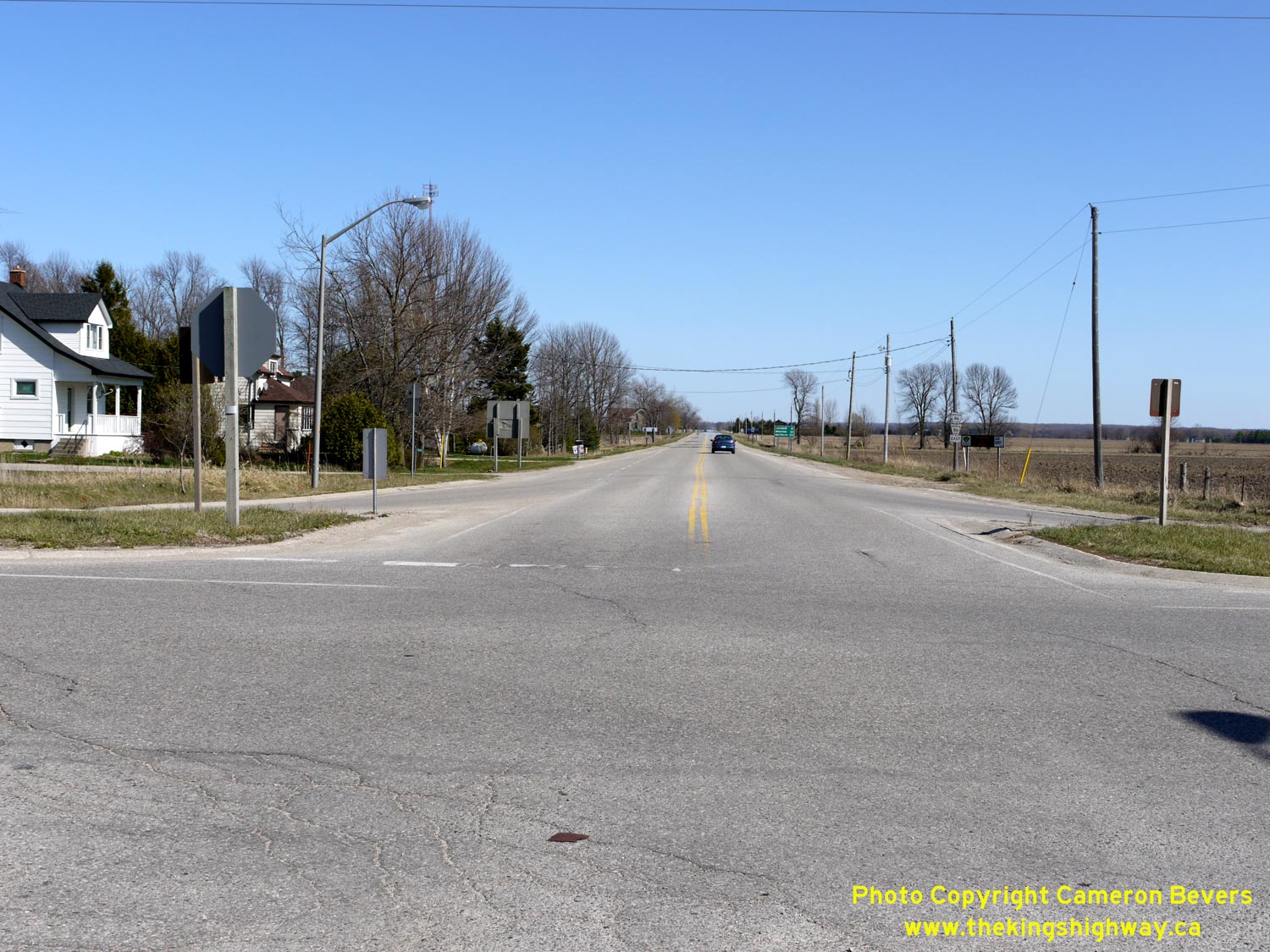
Left - Facing north along Hwy 21 towards Kincardine from Amberley. See an
Enlarged Photo here. (Photograph taken on April 7, 2012 - © Cameron Bevers) Right - Distance guide sign on northbound Hwy 21 departing Amberley. See an Enlarged Photo here. (Photograph taken on April 7, 2012 - © Cameron Bevers)
Continue on to King's Highway 21 Photos: Amberley to Kincardine
|
|---|
Links to Adjacent King's Highway Photograph Pages:
Back to King's Highway 20 Photos /
King's Highway 21 History /
On to King's Highway 22 Photos
Ontario Highway History - Main Menu / Back to List of Highways Website contents, photos & text © 2002-2026, Cameron
Bevers (Webmaster) - All Rights Reserved / Contact Me
|
|---|